10405 Best Sights in USA

Background Illustration for Sights

We've compiled the best of the best in USA - browse our top choices for the top things to see or do during your stay.

Casino Point Dive Park

The crystal clear waters of the Casino Point Dive Park are home to protected marine life. This is where moray eels, bat rays, spiny lobsters, harbor seals, and brilliant orange garibaldi (California's state marine fish) cruise around kelp forests and along the sandy bottom. It's a terrific site for scuba diving, with some shallow areas suitable for snorkeling. Equipment can be rented on-site next to the world-famous Catalina Casino. Water temperature ranges in the mid-60s to low 70s during the summer, with September to mid-October being the warmest.

Gulf Hagas

Part of the Appalachian Trail Corridor, this National Natural Landmark has chasms, cliffs, four major waterfalls, smaller drops, pools, exotic flora, and intriguing rock formations like The Jaws, where outcroppings almost form a land bridge along the gulf or gorge. The West Branch of the Pleasant River drops a few hundred feet as it flows through 3-mile, slate-walled Gulf Hagas east of Greenville. Managed by Maine North Woods and open for public recreation, but not staffed like a park, this remote forest is accessible by gravel logging roads (always yield to logging trucks; roads aren't plowed in winter). A per-person fee is charged during the warm season at entry checkpoints or gates (cash or check only), where you can get trail maps and hiking information.

The difficult Rim Trail and the less challenging Pleasant River Tote Road are approximately 8 to 9 miles, depending on where you start; connector trails create shorter loops. Because of the rim trail's slippery rocks and rugged terrain, hikers are urged to wear sturdy footwear, not sneakers or sandals. Not up for such a rigorous trek? From either parking area you can hike to a premier waterfall on a route that only briefly includes the rim trail. These are good choices for families with young children and anyone lacking the preparation, experience, skill, and time the rim trail demands. From the Gulf Hagas (Lower Gulf) parking area, where most hikers start, it's a 3½–mile round-trip trek to spectacular Screw Auger Falls on the gulf's eastern end. After fording the Pleasant River—usually easily done in summer but dangerous in high water—you'll pass through The Hermitage, a stand of old-growth white pine. Near the falls, there's a stream crossing. From the Head of Gulf (Upper Gulf) parking area, the hike to Stair Falls at the gulf's western end is 3.4 miles round-trip. There's a bridge over the river—no fording required.

La Brea Tar Pits Museum

Miracle Mile

Show your kids where Ice Age fossils come from by taking them to this fascinating outdoor park and indoor museum. Oil rises and bubbles to the earth's surface, as it is collected in shallow pools, and coagulated into asphalt. In the early 20th century, geologists discovered that all that goo contained the largest collection of Pleistocene (Ice Age) fossils ever found at one location. There are more than 600 fossils of species of birds, mammals, plants, reptiles, and insects. Roughly 100 tons of fossil bones have been removed in excavations during the last 100 years, making this one of the world's most famous fossil sites. You can see most of the pits through chain-link fences, and the Excavator Tour gets you as close as possible to the action.

Recommended Fodor's Video

Lake Sammamish State Park

Two sandy beaches anchor this 531-acre park, with plenty of picnic tables (bring your own basket or hit the concession stands), a playground, and seasonal kayak and paddleboard rentals. There are a few shady walking trails, which offer good bird-watching and wildlife viewing. If you head east, you can connect to the Sammamish River Trail and walk or bike all the way to Marymoor Park.

Landscape Arch Trail

This natural rock opening, which measures 306 feet from base to base and looks like a delicate ribbon of rock bending over the horizon, is the longest geologic span in North America. In 1991, a slab of rock about 60 feet long, 11 feet wide, and 4 feet thick fell from the underside, leaving it even thinner. You reach it via a rolling, gravel, 1.8-mile-long trail. Easy.

Los Altos

Arguably best known for its remaining apricot orchards, Mountain View's neighbor, Los Altos, is one of the most charming, Main Street USA–evoking downtowns in the Bay Area—well worth a stroll and a lunch break. Anchored by a grand clock at the intersection of its two main streets, the small business area is split between Main and State Streets, where both run for roughly five blocks. Linden Tree Books ( 265 State St.) is the signature boutique in town, and families drive from many miles away to browse the children's book selection and attend the book talks and other events a few days each month.

Popular breakfast and lunch spots along Main Street include Red Berry Coffee ( 145 Main St.), Manresa Bread ( 271 State St.), Tal Palo ( 149 Main St.) and The American Italian Delicatessen ( 139 Main St.). In the evening, crowds descend upon the contemporary farm-to-table cooking at Roja ( 242 State St.) and Cetrella ( 160 State St.), contemporary Indian cuisine at Aurum ( 132 State St.), yakitori specialist Sumika ( 236 Plaza Central), and craft cocktails at Amandine Lounge ( 235 1st St.). A five-minute drive from downtown takes you to Chef Chu’s ( 1067 N. San Antonio Rd., Suite 1300), an institution for excellent Chinese cooking (its legendary proprietor Larry Chu is also the father of the renowned Hollywood film director Jon M. Chu).

The Museum of Flight

West Seattle

Boeing, the world's largest builder of aircraft, was founded in Seattle in 1916. This facility at Boeing Field, between Downtown and Sea-Tac airport, houses one of the city's best museums, and it's especially fun for kids, who can climb in many of the aircraft and pretend to fly, make flight-related crafts, or attend special programs. The Red Barn, Boeing's original airplane factory, houses an exhibit on the history of flight. The Great Gallery, a dramatic structure designed by Ibsen Nelson, contains more than three dozen vintage airplanes. The Personal Courage Wing showcases World War I and World War II fighter planes, and the Charles Simonyi Space Gallery is home to the NASA Full Fuselage Space Shuttle Trainer.

National Atomic Testing Museum

East Side

Christopher Nolan's film Oppenheimer has renewed interest in that Cold War era of Las Vegas, when visitors could occasionally see a roiling mushroom cloud in the distance at the nearby Nevada Test Site. Located on the corner of the UNLV campus and operated in association with the Smithsonian, the museum is filled with film footage and artifacts from the Test Site, including bomb-testing machinery and the bombs themselves: a decommissioned B-53 "bunker buster" is 12-feet long and weighs 8,850 pounds. Some exhibits are pay homage to the sometimes frightening, sometimes comical treatment of "the bomb" in pop culture. There's a mini-theater that gives you the sensory jolt of an atomic explosion. Two galleries for rotating exhibits augment the permanent exhibition. Early 2025 brought the new "Atomic Odyssey" exhibit, a colorful, interactive, and kid-friendly introduction to the structure of the atom and how to tell nuclear fission from fusion.

The museum also offers virtual tours of the 1,375-square-mile Nevada National Security Site (larger than the state of Rhode Island) and is the starting point for occasional in-person group tours of the test site, which is still operational 65 miles northwest of Downtown. These tours book as much as a year ahead, with museum donors getting first chance.

NoHo Arts District

North Hollywood

In only a few years, North Hollywood's performance arts hub has grown from the residential home of aspiring actors who frequent a few fringe theaters and several chain restaurants to a completely revitalized one square-mile district that boasts a vibrant collection of stages, galleries, dance studios, coffee shops, restaurants, bars, and colorful street art.

Oakland Zoo

One of the West Coast's leading zoos resides in the rolling hills of southeast Oakland. More than 850 animals from near and far live here, often putting on quite a show for the human visitors. The children's zoo and the California Trail are notable areas, with the latter featuring two of the most iconic animals in the Golden State: California condors and grizzly bears. The zoo has a handful of entertaining rides, but the main non-animal highlight for most guests is the Sky Ride gondola that offers incredible Bay Area views.

Rockridge

Rockridge

One of the East Bay's most desirable places to live is this fashionable, upscale neighborhood. Explore the tree-lined streets that radiate out from College Avenue, just north and south of the Rockridge BART station for a look at California Craftsman bungalows at their finest. By day, College Avenue between Broadway and Alcatraz Avenue is crowded with shoppers buying fresh flowers, used books, and clothing; by night, the same folks are back for satisfying meals filled with fresh local ingredients, artisanal wines, and locally brewed ales. There's even a cider bar, one of the few in the Bay Area (Redfield Cider Bar & Bottle Shop 5815 College Ave.). With its specialty food shops and quick bites to go, Market Hall, an airy European-style marketplace at Shafter Avenue, is a hub of culinary activity, including the wonderful Californian-Mediterranean cooking of the attached Acre Kitchen & Bar ( 5655 College Ave.).

Smith Tower

Pioneer Square

When this iconic landmark opened in 1914, it was the tallest office building outside New York City and the fourth-tallest building in the world. (It remained the tallest building west of the Mississippi for nearly 50 years.) The Smith Tower Observatory on the 35th floor is an open-air wraparound deck providing panoramic views of the surrounding historic neighborhood, ball fields, the city skyline, and the mountains on clear days. It's also a superb spot to take in a sunset. The top floor includes the speakeasy-themed Observatory Bar, which features striking original architectural details and a cocktail and nibbles menu that pays homage to the Prohibition era. Smith Tower's ground-floor retail shop packed with locally made goods is also worth a visit.

Stinson Beach

When the fog hasn't rolled in, this expansive stretch of sand is about as close as you can get in Marin to the stereotypical feel of a Southern California beach. There are several clothing-optional areas, among them a section south of Stinson Beach called Red Rock Beach. Pets are not allowed on the national park section of the beach.

Swimming at Stinson Beach can be dangerous; the undertow is strong, and shark sightings, though infrequent, have occurred. Lifeguards are on duty in the summer months.

On any hot summer weekend, roads to Stinson are packed and the parking lot fills, so factor this into your plans. The town itself—population 600, give or take—has a nonchalant surfer vibe, with a few good eating options and pleasant hippie-craftsy browsing. Amenities: food and drink; lifeguards (summer); parking (no fee); showers; toilets. Best for: nudists; sunset; surfing; swimming; walking, windsurfing.

Sunset Boulevard

West Hollywood

Sunset Boulevard is a sexy and seductive drive with bigger than life celebrity billboards, architecturally unique hotels, a variety of casual to upscale restaurants, and fashionable boutiques. The cocktail bars charge a premium, but the iconic Hollywood sign and Los Angeles views justify the price.

Tilden Regional Park

Stunning bay views, a kid's steam train, and a botanical garden with a comprehensive collection of California plant life are the hallmarks of this 2,077-acre park in the hills just east of the UC Berkeley campus. The garden's visitor center offers weekend lectures about its plants and information about Tilden's other attractions, including its picnic spots, Lake Anza swimming site, golf course, and hiking trails (the paved Nimitz Way, at Inspiration Point, is a popular hike with wonderful sunset views). Children love Tilden's interactive Little Farm and vintage carousel.

University Avenue

Downtown Palo Alto’s main street is a continuation of Stanford’s Palm Drive after the university stretch reaches the Caltrain station. Shops, restaurants, and an always-popular Apple Store (it’s no different than other stores but considered special since Steve Jobs lived nearby) line the blocks of the street until it becomes residential.

The crown jewel is the Stanford Theatre ( 221 University Ave.), a magnificent ode to classic Hollywood. Across the street is Lytton Plaza, a spacious, eclectic gathering place where surely somebody will be putting on an impromptu concert or protest. Toward the eastern end of the downtown area is what previously was another Hollywood Golden Age cinema, the Varsity Theatre. Its classic Colonial Spanish and Mission Revival–influenced architecture is still stunning and, in typical 2025 fashion, has a Blue Bottle Coffee café ( 456 University Ave.).

There are dining highlights up and down University Avenue, led by contemporary Vietnamese stalwart Tamarine ( 546 University Ave.) and the silky hummus specialty at Oren’s Hummus ( 261 University Ave.). The quieter side streets off University Avenue also feature several standout restaurants including Ramen Nagi ( 541 Bryant St.), the Georgian cooking of Bevri ( 530 Bryant St.), craft cocktails with excellent French bistro fare at Zola and BarZola ( 565 and 585 Bryant St.), outstanding seasonal contemporary cooking and a unique martini rendition at Ethel's Fancy ( 550 Waverley St.), contemporary Indian cuisine in lavish surroundings at Ettan ( 518 Bryant St.), and Taverna’s ( 800 Emerson St.) excellent modern and rustic Greek dishes.

University Ave., Palo Alto, CA, 94301, USA

Something incorrect in this review?

University of California, Berkeley

Known simply as "Cal," the founding campus of California's university system is one of the leading intellectual centers in the United States and a major site for scientific research. Chartered in 1868, the university sits on 178 oak-covered acres split by Strawberry Creek. Campus highlights include bustling and historic Sproul Plaza ( Bancroft Way and Sather Rd.), the 307-foot-tall and 61-bell carillon of Sather Tower ( Campanile Esplanade), hands-on Lawrence Hall of Science ( 1 Centennial Dr.), the vibrant 34-acre Botanical Gardens ( 200 Centennial Dr.), and the historic Hearst Greek Theatre ( 2001 Gayley Rd.), the classic outdoor amphitheater designed by John Galen Howard (who also designed Sather Tower).

Wrigley Memorial and Botanic Garden

Walk 2 miles south of the bay up to Wrigley Memorial and Botanic Garden, home to many plants native only to Southern California and the Channel Islands. Today there are five different sections where you can see Catalina ironwood, wild tomato, and rare Catalina mahogany. The Wrigley family commissioned the garden as well as the monument, which has a grand staircase and a Spanish-style mausoleum inlaid with colorful Catalina tile. You'll find great views at the top.

16th Street Mall

LoDo Fodor's Choice
DENVER - JUNE 25. View of 16th Street Pedestrial Mall of red-and-grey Granite that Runs Through the Center of Downtown. Free Shuttle Buses Cruise the mile-long Mall. Denver, Co, June 25, 2013
Albert Pego / Shutterstock

Outdoor cafés and tempting shops line this pedestrian-only 18-block, 1¼-mile thoroughfare, shaded by red-oak and locust trees. The mall's businesses run the entire socioeconomic range. There are popular meeting spots for business types at places like the Yard House in the Sheraton Hotel; a front-row view of the many street performers and goings-on from restaurants' sidewalk patios; and plenty of fast-food chains. Although some Denverites swear by the higher-end Cherry Creek Shopping District, the 16th Street Mall covers every retail area and is a more affordable, diverse experience. You can find Denver's best people-watching here. Catch one of the free shuttle buses at any corner that run the length of downtown. Pay attention when you're wandering across the street, as the walking area and bus lanes are the same color and are hard to distinguish.

875 N. Michigan Avenue (formerly the John Hancock Center) and 360 Chicago

Near North Side Fodor's Choice
Chicago skyline view from John Hancock Observatory
(c) Sidneyboot | Dreamstime.com

Designed by Skidmore, Owings & Merrill, this multipurpose skyscraper is distinguished by its tapering shape and enormous X braces, which help stabilize its 100 stories. Soon after it went up in 1970, it earned the nickname "Big John." No wonder: it's 1,127 feet tall (the taller east tower is 1,506 feet counting its antennae). Packed with retail space, parking, offices, a restaurant, and residences, it has been likened to a city within a city. Like the Willis Tower, which was designed by the same architectural team, this skyscraper offers views of four states on clear days. To see them, ascend to the 94th-floor observatory—now dubbed 360 Chicago ($30). While there, visitors can grab a cocktail, beer, wine, hot drink or nonalcoholic beverage at Bar 94, which can only be accessed with a General Admission ticket. Thrill seekers can pay an additional fee to take advantage of the tower's most exciting feature, The Tilt ($8), which has eight windows that tilt downward to a 30-degree angle, giving you a unique perspective on the city below. Those with vertigo might prefer a seat in the bar of the 96th-floor Signature Lounge; the tab will be steep, but you don't pay the observatory fee and you'll be steady on your feet.

9/11 Memorial & Museum

Financial District Fodor's Choice
NEW YORK - MAY 27: NYC's 9/11 Memorial at World Trade Center Ground Zero seen on May 27, 2013. The memorial is located at the World Trade Center site, on the former location of the Twin Towers
(c) Marcorubino | Dreamstime.com

Opened in 2011 to mark the 10th anniversary of the September 11, 2001, terrorist attacks, the somber 9/11 Memorial is an open-access, free public plaza occupying much of the 16-acre World Trade Center site. It comprises two giant, recessed square footprints lined with 30-foot-tall waterfalls marking where the Twin Towers once stood. Edging the memorial pools are bronze panels inscribed with the names of the nearly 3,000 people who were killed in the 1993 and 2001 terrorist attacks. Around the plaza are benches, grassy strips, and more than 400 swamp white oak trees harvested from within a 500-mile radius of the site, as well as from Pennsylvania and the Washington, D.C., area. Be sure to stop at the remarkable Callery pear "Survivor Tree" that, rather miraculously, withstood the 2001 attacks and was nurtured back to health.

Along Liberty Street on the south side of the site is the elevated Liberty Park, home to Fritz Koenig's The Sphere, which for three decades stood on the plaza at the World Trade Center as a symbol of peace. Damaged in the 2001 attacks, the sculpture was installed in the park in 2017. On the park's east end stands St. Nicholas Greek Orthodox Church and National Shrine ( stnicholaswtc.org), erected to replace the church that was destroyed on 9/11. Unlike an average church, this house of worship cost $85 million, took 21 years to design and construct, and among its splendid features, was built with white marble sourced from the same Greek quarry as the Parthenon's stone. Visitors are welcome daily (except Tuesday), 10–3.

Beside the twin pools that form the 9/11 Memorial Plaza is the glass pavilion of the 9/11 Memorial Museum. The museum descends some seven stories down to the Twin Towers' original bedrock foundations, and the vast space displays a poignant, powerful collection of artifacts, memorabilia, photographs, and multimedia exhibits, as well as a gallery that takes visitors through the history of events surrounding both the 1993 and 2001 attacks. You might appreciate the tissue boxes around the museum when beholding the memorial wall with portraits and personal stories of those who perished. There's a panoramic media installation about the site's "rebirth," as well as World Trade Center–related art and history exhibits that change throughout the year. Giant pieces of the towers' structural steel and foundations are displayed, along with the partially destroyed Ladder Company 3 fire truck. You can also see the remnants of the Survivors Stairs, which allowed hundreds of people to escape the buildings that fateful September day. (Check the website for current ticket packages and other discounts.)

180 Greenwich St., New York, NY, 10007, USA
212-266–5211-general information
Sight Details
Memorial is free; museum admission $36

Something incorrect in this review?

Adler Planetarium and Astronomy Museum

South Loop Fodor's Choice
Adler Planetarium, located in downtown Chicago.
Henryk Sadura / Shutterstock

Taking you on a journey through the stars to unlock the mysteries of our galaxy and beyond, the Adler tells amazing stories of space exploration through high-tech exhibits and immersive theater experiences. Artifacts and interactive elements bring these fascinating tales of space and its pioneers down to earth. The Grainger Sky Theater gives an up-close view of stunning space phenomena, and the magnificent imagery is so realistic that it might only be surpassed by actual space travel. The newest permanent exhibit is The Universe: A Walk Through Space and Time. A spectacular projection showcases the enormity of the universe, and touch screens let you investigate diverse and beautiful objects from deep space.

Akaka Falls State Park

Fodor's Choice
Akaka Falls State Park, Big Island, Hawaii
© Peter Guttman/PeterGuttman.com

A paved, 10-minute loop trail (approximately ½ mile) takes you to the best spots to see the spectacular cascades of Akaka, including the majestic upper Akaka Falls, which drops more than 442 feet. It tumbles far below into a pool drained by Kolekole Stream amid a profusion of fragrant white, yellow, and red torch ginger and other tropical foliage. Another 400-foot falls is on the lower end of the trail. Restroom facilities are available but no drinking water. The park is 4 miles inland, and vehicle parking closes at 6. Visitors are encouraged to reserve parking online in advance at this popular spot. A series of steps along parts of the trail may prove challenging for some visitors, and they are not wheelchair accessible.

875 Akaka Falls Rd., Honomu, HI, 96728, USA
808-974–6200
Sight Details
$5 per vehicle; parking $10

Something incorrect in this review?

Ala Moana Regional Park

Ala Moana Fodor's Choice
A view of Ala Moana from the park-lands point, situated on the island of Oahu, Hawaii.
(c) Dubphoto | Dreamstime.com

A protective reef makes Ala Moana essentially a ½-mile-wide saltwater swimming pool. Very smooth sand and no waves create a haven for families and stand-up paddleboarders. After Waikiki, this is the most popular beach among visitors, and the free parking area can fill up quickly on sunny weekends. On the Waikiki side is a peninsula called Magic Island, with shady trees and paved sidewalks ideal for jogging. Ala Moana Regional Park also has playing fields, tennis courts, and a couple of small ponds for sailing toy boats. The beach is for everyone, but only in the daytime; after dark, it's a high-crime area, with many unhoused people. Amenities: food and drink; lifeguards; parking (free); showers; toilets. Best for: swimming; walking.

Alki Point and Beach

West Seattle Fodor's Choice
Lighthouse on Alki, Seattle, WA
HansUntch / iStockphoto

In summer, this is as close to California as Seattle gets—and some hardy residents even swim in the cold, salty waters of Puget Sound here (water temperature ranges from 45ºF to 60ºF). This 2½-mile stretch of sand has views of the Seattle skyline and the Olympic Mountains, and the beachfront promenade is especially popular with skaters, joggers, strollers, and cyclists. Year-round, Seattleites come to build sand castles, beachcomb, play volleyball, fly kites, enjoy the views, and people watch; in winter, storm-watchers come to see the crashing waves. Facilities include drinking water, grills, picnic tables, and restrooms; restaurants line the street across from the beach. 

Alki Point is the place where David Denny, John Low, and Lee Terry arrived in September 1851, ready to found a city. The Alki Point Lighthouse dates from 1913. One of 195 Lady Liberty replicas found around the country, Miss Liberty (or Little Liberty) lives near the 2700 block of Alki Avenue SW and is a popular meeting point for beachfront picnics and dates.

To get to the beach from Downtown, take either Interstate 5 south or Highway 99 south to the West Seattle Bridge (keep an eye out, as this exit is easy to miss) and exit onto Harbor Avenue SW, turning right at the stoplight. After Harbor Ave. SW curves south to become Alki Ave. SW, watch for the Alki Flower Houses on the left at 1400 Alki Ave. SW. The pair of 1914 houses, tucked between two high-rise condominium buildings, overflow with vibrant blossoms, inspired by owner Randie Stone's Hawaiian upbringing and nurturing the property's status as a wildlife habitat, while making it a photo-worthy gem. Alki Beach is a three-minute drive south from here.

American Museum of Natural History

Upper West Side Fodor's Choice
The famous American Museum for National History holds a large collection of prehistoric and human exhibits from all over the world.  Open for public at July 8,2010, New York,  USA.
Jorg Hackemann / Shutterstock

With more than 40 exhibition halls and 34 million artifacts and specimens, the world's largest and most important museum of natural history can easily keep you occupied for more than a day. The dioramas might seem a bit dated but are still fun; dinosaur fossils and exhibits, including a massive T. rex, are highlights for many people, especially kids. A 94-foot model of a blue whale, another museum icon, is suspended from the ceiling in the Milstein Hall of Ocean Life. Attached to the museum is the Rose Center for Earth and Space featuring various exhibits, the Hayden Planetarium, a giant-screen theater, and the Worlds Beyond Earth space show, which takes you on a cosmic journey to the inner reaches of our solar system. Do your bling thing at the dazzling Mignone Halls of Gems and Minerals, displaying giant geodes, diamonds, and sapphires, and explore the revitalized Northwest Coast Hall, where you will find exhibits on the history and creativity of the cultures of the Pacific Northwest. The latest addition to this ever-changing museum is the Richard Gilder Center for Science, Innovation, and Education, which opened in mid-2023 adding an organic, canyonlike atrium with large skylights to create a welcoming new space for discovery; new galleries dedicated to insects; a permanent butterfly vivarium; classrooms; a research library; and a state-of-the-art theater-in-the-round. 

Many family-friendly events, including storytelling and dance performances, are included with admission. Purchase timed entry tickets in advance, and check the website for special programs, including sleepovers for kids.

200 Central Park W, New York, NY, 10024, USA
212-769–5100
Sight Details
$30 includes admission to Rose Center for Earth and Space; $36 includes one ticketed exhibition, giant-screen film, or space show

Something incorrect in this review?

Anaehoomalu Bay

Fodor's Choice
Young woman sits on the lava rocks of Anaehoomalu Bay on the Kohala Coast of the Big Island of Hawaii.  She is watching a green sea turtle that is basking in the sunlight and resting.
Bonita R. Cheshier / Shutterstock

This gorgeous, expansive stretch of white sand, fringed with coconut palms, fronts the Waikoloa Beach Marriott and is a perfect spot for swimming, windsurfing, snorkeling, and diving. Unlike some Kohala Coast beaches near hotel properties, this one is very accessible to the public and offers plenty of free parking. The bay is well protected, so even when the surf is rough or the trade winds are blasting, it's fairly calm here. (Mornings are calmest.) Snorkel gear, kayaks, and body boards are available for rent at the north end.

 Locals will appreciate your efforts to use the proper name (pronounced ā'-nāe-ho'o-mā'lu) rather than simply its nickname, "A-Bay."

Behind the beach are two ancient Hawaiian fishponds, Kuualii and Kahapapa, that once served ancient Hawaiian royalty. A walking trail follows the coastline to the Hilton Waikoloa Village next door, passing by tide pools, ponds, and a turtle sanctuary where sea turtles can often be spotted sunbathing on the sand. Footwear is recommended for the trail. Amenities: food and drink; parking (no fee); showers; toilets; water sports. Best for: snorkeling; sunset; swimming; walking.

69-275 Waikoloa Beach Dr., Waikoloa, HI, 96738, USA
Sight Details
Free

Something incorrect in this review?

Anna Ranch Heritage Center

Fodor's Choice
Anna Ranch, Kamuela, Hawaii 189/365. A historic landmark with beautiful gardens.
Anna Ranch, Kamuela, Hawaii 189/365 by Jen R

On the National and State Registers of Historic Places, this stunning heritage property belonged to the "first lady" of Hawaii ranching, Anna Lindsey Perry-Fiske, and now provides a rare opportunity to see a fully restored cattle ranch compound and learn about the life of this fascinating woman. She rounded up and butchered cattle by day and threw lavish parties by night. Wander the picturesque grounds and gardens on a self-guided walk, watch a master saddlemaker and an ironsmith in action, and take a guided tour (by appointment only) of the historic house, where Anna's furniture, gowns, and elaborate pau (parade riding) costumes are on display. The knowledgeable staff shares anecdotes about Anna's life. (Some staff and visitors have even reported strange goings-on in the main house, suggesting that Anna may still be "hanging around.")

65-1480 Kawaihae Rd., Waimea (Hawaii County), HI, 96743, USA
808-885–4426
Sight Details
Grounds and Discovery Trail free, historic home tours $10
Closed Sat.–Mon.

Something incorrect in this review?

Anza-Borrego Desert State Park

Fodor's Choice
Wildflower blooming in Anza Borrego Desert State Park, California.
sumikophoto / Shutterstock

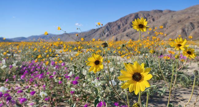
One of the richest living natural-history museums in the nation, this state park is a vast, nearly uninhabited wilderness where you can step through a field of wildflowers, cool off in a palm-shaded oasis, count zillions of stars in the black night sky, and listen to coyotes howl at dusk. The landscape, largely undisturbed by humans, reveals a rich natural history. There's evidence of a vast inland sea in the piles of oyster beds near Split Mountain and of the power of natural forces such as earthquakes and flash floods. In addition, recent scientific work has confirmed that the Borrego Badlands, with more than 6,000 meters of exposed fossil-bearing sediments, is likely the richest such deposit in North America, telling the story of 7 million years of climate change, upheaval, and prehistoric animals. Evidence has been unearthed of saber-toothed cats, flamingos, zebras, and the largest flying bird in the northern hemisphere beneath the now-parched sand. Today the desert's most treasured inhabitants are the herds of elusive and endangered native bighorn sheep, or borrego, for which the park is named. Among the strange desert plants you may observe are the gnarly elephant trees. As these are endangered, rangers don't encourage visitors to seek out the secluded grove at Fish Creek, but there are a few examples at the visitor center garden. After a wet winter you can see a short-lived but stunning display of cacti, succulents, and desert wildflowers in bloom.

The park is unusually accessible to visitors. Admission to the park is free, and few areas are off-limits. There are two developed campgrounds, but you can camp anywhere; just follow the trails and pitch a tent wherever you like. There are more than 500 miles of dirt roads, two huge wilderness areas, and 110 miles of riding and hiking trails. Many sites can be seen from paved roads, but some require driving on dirt roads, for which rangers recommend you use a four-wheel-drive vehicle. When you do leave the pavement, carry the appropriate supplies: a cell phone (which may be unreliable in some areas), a shovel and other tools, flares, blankets, and plenty of water. The canyons are susceptible to flash flooding, so inquire about weather conditions (even on sunny days) before entering.

Borrego resorts, restaurants, and the state park have Wi-Fi, but the service is spotty at best. If you need to talk to someone in the area, it's best to find a phone with a landline.

Stop by the visitor center to get oriented, to pick up a park map, and to learn about weather, road, and wildlife conditions. Designed to keep cool during the desert's blazing-hot summers, the center is built underground, beneath a demonstration desert garden containing examples of most of the native flora and a little pupfish pond. Displays inside the center illustrate the natural history of the area. Picnic tables are scattered throughout, making this a good place to linger and enjoy the view.

The sites and hikes listed below are arranged by region of the park and distance from the visitor center: in the valley and hills surrounding Borrego Springs, near Tamarisk Campground, along Highway S2, south of Scissors Crossing, and south of Ocotillo Wells.

A 1½-mile trail leads to Borrego Palm Canyon, one of the few native palm groves in North America. The canyon, about 1 mile west of the visitor center, holds a grove of more than 1,000 native fan palms, a stream, and a waterfall. Wildlife is abundant along this route. This moderate hike is the most popular in the park.

With a year-round stream and lush plant life, Coyote Canyon, approximately 4½ miles north of Borrego Springs, is one of the best places to see and photograph spring wildflowers. Portions of the canyon road follow a section of the old Anza Trail. This area is closed between June 15 and September 15 to allow native bighorn sheep undisturbed use of the water. The dirt road that gives access to the canyon may be sandy enough to require a four-wheel-drive vehicle.

The late-afternoon vista of the Borrego badlands from Font's Point, 13 miles east of Borrego Springs, is one of the most breathtaking views in the desert, especially when the setting sun casts a golden glow in high relief on the eroded mountain slopes. The road from the Font's Point turnoff can be rough enough to make using a four-wheel-drive vehicle advisable; inquire about road conditions at the visitor center before starting out. Even if you can't make it out on the paved road, you can see some of the view from the highway.

East of Tamarisk Grove campground (13 miles south of Borrego Springs), the Narrows Earth Trail is a short walk off the road. Along the way you can see evidence of the many geologic processes involved in forming the canyons of the desert, such as a contact zone between two earthquake faults, and sedimentary layers of metamorphic and igneous rock.

The 1.6-mile round-trip Yaqui Well Nature Trail takes you along a path to a desert water hole where birds and wildlife are abundant. It's also a good place to look for wildflowers in spring. At the trailhead across from Tamarisk Campground you can pick up a brochure describing what can be seen along the trail.

Traversing a boulder-strewn trail is the easy, mostly flat Pictograph/Smuggler's Canyon Trail. At the end is a collection of rocks covered with muted red and yellow pictographs painted within the last hundred years or so by Native Americans. Walk about ½ mile beyond the pictures to reach Smuggler's Canyon, where an overlook provides views of the Vallecito Valley. The hike, from 2 to 3 miles round-trip, begins in Blair Valley, 6 miles southeast of Highway 78, off Highway S2, at the Scissors Crossing intersection.

Just a few steps off the paved road, Carrizo Badlands Overlook offers a view of eroded and twisted sedimentary rock that obscures the fossils of the mastodons, saber-tooths, zebras, and camels that roamed this region a million years ago. The route to the overlook through Earthquake Valley and Blair Valley parallels the Southern Emigrant Trail. It's off Highway S2, 40 miles south of Scissors Crossing.

Geology students from all over the world visit the Fish Creek area of Anza-Borrego to explore the canyon through Split Mountain. The narrow gorge with 600-foot walls was formed by an ancient stream. Fossils in this area indicate that a sea once covered the desert floor. From Highway 78 at Ocotillo Wells, take Split Mountain Road south 9 miles.

200 Palm Canyon Dr., Borrego Springs, CA, 92004, USA
760-767–4205
Sight Details
Free; day-use parking in campground areas $10
Park daily dawn–dusk. Visitor Center Oct.–May 1, daily 9–5
Make a campground reservation at: reservecalifornia.com

Something incorrect in this review?

Aquinnah Cliffs

Aquinnah Fodor's Choice
Aquinnah Cliffs at Martha's Vineyard
(c) Mwaits | Dreamstime.com

A National Historic Landmark, the spectacular Aquinnah Cliffs are part of the Wampanoag Reservation land. These dramatically striated walls of red clay are the island's major attraction, as evidenced by the tour bus–filled parking lot. Native American crafts and food shops line the short approach to the overlook. Gaze toward the Elizabeth Islands to the northeast across Vineyard Sound and Nomans Land Island, a wildlife preserve, 3 miles off the Vineyard's southern coast.

State Rd., Martha's Vineyard, MA, 02535, USA

Something incorrect in this review?