425 Best Sights in USA

Background Illustration for Sights

We've compiled the best of the best in USA - browse our top choices for the top things to see or do during your stay.

Height of Land

Fodor's Choice

Height of Land is the highlight of—and the highest point along—Rangeley Lakes National Scenic Byway, with unforgettable views of mountains and lakes. One of Maine's and even New England's best overlooks, it hugs Route 17 atop Spruce Mountain several miles south of Rangeley's Oquossoc village. It's a twisty drive up on forest-lined roads whether you're coming that way or from the south, but however you get here you'll be amply rewarded. Mooselookmeguntic and Upper Richardson lakes sprawl amid the forestland below. On a clear day, you can look west to the White Mountains on the Maine–New Hampshire border. There's off-road parking, interpretive panels, and stone seating. Hit the Appalachian Trail for a day hike—it crosses Height of Land. Rangeley Lake unfolds at a nearby overlook on the opposite side of the road, north of here toward Oquossoc.

Los Altos

Arguably best known for its remaining apricot orchards, Mountain View's neighbor, Los Altos, is one of the most charming, Main Street USA–evoking downtowns in the Bay Area—well worth a stroll and a lunch break. Anchored by a grand clock at the intersection of its two main streets, the small business area is split between Main and State Streets, where both run for roughly five blocks. Linden Tree Books ( 265 State St.) is the signature boutique in town, and families drive from many miles away to browse the children's book selection and attend the book talks and other events a few days each month.

Popular breakfast and lunch spots along Main Street include Red Berry Coffee ( 145 Main St.), Manresa Bread ( 271 State St.), Tal Palo ( 149 Main St.) and The American Italian Delicatessen ( 139 Main St.). In the evening, crowds descend upon the contemporary farm-to-table cooking at Roja ( 242 State St.) and Cetrella ( 160 State St.), contemporary Indian cuisine at Aurum ( 132 State St.), yakitori specialist Sumika ( 236 Plaza Central), and craft cocktails at Amandine Lounge ( 235 1st St.). A five-minute drive from downtown takes you to Chef Chu’s ( 1067 N. San Antonio Rd., Suite 1300), an institution for excellent Chinese cooking (its legendary proprietor Larry Chu is also the father of the renowned Hollywood film director Jon M. Chu).

Central Park

Upper West Side Fodor's Choice
Central Park aerial view, Manhattan, New York; Park is surrounded by skyscraper.
T photography / Shutterstock

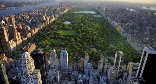
Central Park's creators, landscape architects Frederick Law Olmsted and Calvert Vaux, had a simple goal when they submitted their plan in 1858: to design a place where city dwellers could go to forget the city. Even though New York eventually grew far taller than the trees planted to hide it, the park has always been an urbanized Eden that gives residents and visitors alike a bite of the apple. Indeed, without Central Park's 843 acres of meandering paths, tranquil lakes, ponds, and open meadows, New Yorkers (especially Manhattanites) might be a lot less sane. Olmsted and Vaux also designed Brooklyn's Prospect Park and the grounds of the White House.

The busy southern section of Central Park, from 59th to 72nd Street, is where most people get their first impression. But no matter how many people congregate around here, you can always find a spot to picnic, ponder, or just take in the foliage, even on a sunny weekend day. In the southern corner is the Hallett Nature Sanctuary, one of the park's lesser-known areas. The nature sanctuary is a 4-acre patch of wilderness—one of the park’s three woodlands—and is home to native flora and fauna and rustic trails that lead to quiet overlooks; it's also a popular birding spot. Playgrounds, lawns, jogging and biking paths, and striking buildings populate the midsection of the park, from 72nd Street to the reservoir. You can soak up the sun, take in the public art, take pictures at Bethesda Fountain, visit the penguins at the Central Park Zoo, or join the runners huffing counterclockwise on the dirt track that surrounds the reservoir. North of the reservoir and up to 110th Street, Central Park is less crowded and feels more rugged. In 2025, the Central Park Conservancy completed a revitalization of the area around the Harlem Meer (a man-made lake) at the north end of the park to add a full-scale ice rink, an additional new skating experience on the meer, a larger-than-Olympic-size pool, and revamp the parkland around it. The new facility is called the Davis Center at the Harlem Meer (formerly the Lasker Rink and Pool site). To find out about park events and year-round walking tours, check the website of the Central Park Conservancy ( www.centralparknyc.org).

If you're taking the subway to the park's southernmost parts, the stops at either Columbus Circle (southwest corner) or 5th Avenue–59th Street (southeast corner) are handy. If headed for points north, the A, B, C, and D subway lines travel along Central Park West (beware of local versus express stops); the 4, 5, and 6 lines travel along Lexington Avenue, three blocks east of 5th Avenue and the park.

There are many paved pedestrian entrances into the park from 5th Avenue, Central Park North (110th Street), Central Park West, and Central Park South (59th Street). Four roads, or transverses, for cars and city buses cut through the park from east to west—66th, 79th, 86th, and 96th Streets. The East and West drives are both along the north–south axis; Center Drive enters the south edge of the park at 6th Avenue and connects with East Drive around 66th Street. Cars are no longer allowed on the drives, which are exclusively for pedestrians, cyclists, and horse-drawn carriages. Along the main loop, lampposts are marked with location codes that include a letter—always "E" (for east) or "W" (for west)—followed by numbers, the first two of which tell you the nearest cross street. For example, E7803 means you're near 78th Street; above 99, the initial "1" is omitted, so W0401 is near West 104th Street. Download the Central Park Conservancy's free app for a GPS-enabled map to help you navigate the park. The app also includes an audio guide, self-guided tours, and current events in the park, as well as a new interactive Cherry Blossom Tracker Map to help visitors and locals track when and where the flowers will peak in the park in spring.

If you haven't packed a picnic and you want a snack, you can usually find one of those rather tired-looking food carts selling hot dogs, pretzels, and ice-cream sandwiches. Specialty food carts are often around, too, mostly in the park's southern half, especially when there are concerts or other major events—your taste buds will thank you. Other reliable options include the café next to the Boathouse Restaurant (midpark at 74th Street), or a branch of Le Pain Quotidien (midpark at 69th Street). Both serve sandwiches, soups, pastries, and other satisfying on-the-go grub (and Le Pain also has free Wi-Fi). For something a little more elegant, you can stop for brunch, lunch, or dinner at the Tavern on the Green.

As part of a park-wide restoration project named Plan for Play, all 21 playgrounds have undergone (or are still scheduled to receive) updates. Most have seen renovations to play structures, plus other improvements that will ensure each one's structural stability and ongoing maintenance for years to come.

Recommended Fodor's Video

City Park

Mid-City Fodor's Choice
The Parthenon is the most recognizable peice of architecture in New Orlean's City Park. It sits across a placid lake and is flanked by majestic oaks and ornamental palms.
(c) Mishelmccumber | Dreamstime.com

Founded in 1854, this 1,300-acre expanse of moss-draped oaks and 11 miles of gentle lagoons is only 2 miles from the French Quarter, but feels like it could be a world apart. With the largest collection of live oaks in the world, including old grove trees that are more than 600 years old, City Park offers a certain natural majesty that's difficult to find in most other urban areas. The Art Deco benches, fountains, bridges, and ironwork are remnants of a 1930s Works Progress Administration (WPA) refurbishment and add to the dreamy scenery that visitors enjoy boating and bicycling through. Within the park are the New Orleans Museum of Art, the Louisiana Children's Museum, the Sydney and Walda Besthoff Sculpture Garden, the New Orleans Botanical Garden, the kid-friendly Carousel Gardens Amusement Park, as well as a golf course, equestrian stable, sports facilities, and picnic areas. Check the park's website for seasonal activities and special events, such as music festivals, the annual Easter egg hunt, and the eye-popping wonderland that is Celebration in the Oaks between Thanksgiving and New Year's Day. The Café du Monde coffee stand, behind the Sculpture Garden, serves hot beignets and café au lait 24/7. Most of the park's offerings are free, but several of the venues inside City Park charge separate admission fees.

Open seasonally on the weekends, the 18-ride Carousel Gardens Amusement Park ( 504/483–9402  $25 admission, unlimited rides) has a New Orleans treasure as its centerpiece: a 1906 carousel (one of only 100 antique wooden carousels left in the country) listed on the National Register of Historic Places. In addition to the cherished "flying horses," the park has rides like the Musik Express, Rockin' Tug, Coney Tower, Ferris Wheel, Bumper Cars, Monkey Jump, Red Baron miniplane, Scrambler, and Tilt-a-Whirl. The rides here are mostly geared to children, not hard-core thrill seekers, but adults and kids alike enjoy the miniature train that takes passengers on a gentle sightseeing tour through City Park. There are also two 18-hole miniature golf courses, one with a New Orleans theme and one with a Louisiana theme.

The New Orleans Botanical Garden ( 504/483–9402  $12), opened in 1936 as a Depression-era project of the WPA, is one of the few remaining examples of public garden design from the Art-Deco period. The garden's collections contain more than 2,000 varieties of plants from all over the world, complemented by sites such as the Conservatory, the Pavilion of the Two Sisters, and the Yakumo Nihon Teien Japanese Garden, as well as theme gardens containing aquatics, roses, native plants, ornamental trees, and shrubs and perennials. The garden showcases three notable talents: New Orleans architect Richard Koch, landscape architect William Wiedorn, and artist Enrique Alférez. Adding a touch of fun, the Historic Train Garden, open on weekends and included in Botanical Garden admission, offers visitors the chance to enjoy baguette-size cars rolling through a miniature version of New Orleans.

Featuring figures and settings from classic children's literature, the whimsical Storyland ( 504/483–9402  $6), adjacent to the amusement park, has been a favorite romping ground for generations of New Orleans kids. Youngsters can climb aboard Captain Hook's pirate ship, visit the old lady who lived in a shoe, and journey with Pinocchio into the mouth of a whale. In all, there are 18 larger-than-life storybook exhibits to explore.

Forsyth Park

Fodor's Choice
Forsyth Park Fountain in Savannah Georgia.; Shutterstock ID 1711880; Project/Title: Fodors; Downloader: Melanie Marin
David Davis / Shutterstock

The heart of the city's outdoor life, Forsyth Park hosts a number of popular cultural events, including film screenings, sports matches, and the annual Savannah Jazz Festival. Built in 1840 and expanded in 1851, the park was part of General Oglethorpe's original city plan and made possible by the donation of land from Georgia governor John Forsyth. A glorious white fountain dating to 1858, Confederate and Spanish-American War memorials, a fragrant garden, multiple playgrounds, tennis and basketball courts, and an old fort (which houses the gorgeous Collins Quarter Forsyth Café, with indoor/outdoor seating) are spread across this grand, green space. Be sure to stop by the south end on Saturday mornings for the bustling farmers' market. The park's 1-mile perimeter is among the prettiest walks in the city and takes you past many beautifully restored historic homes.

Mission Dolores Park

Fodor's Choice
Dolores Park in San Francisco, looking northeast toward downtown.
(c) Rahurlburt | Dreamstime.com

A two-square-block microcosm of life in the district, Mission Dolores Park is one of San Francisco's liveliest green spaces: dog lovers and their pampered pups congregate, kids play at the extravagant playground, and hipsters hold court, drinking beer and rosé cans on sunny days. (Fair warning: if it's over 70°F, the place can get packed like traffic at rush hour for picnic-blanket space.) During the summer, Dolores Park hosts movie nights, performances by the San Francisco Mime Troupe, and pop-up events and impromptu parties. Spend a warm day here—maybe sitting at the top of the park with a view of the city and the Bay Bridge—surrounded by locals and that laid-back, still-abundant San Francisco energy, and you may well find yourself plotting your move to the city. The best views are in the southwest corner, near the historic Golden Fire Hydrant that saved the neighborhood after the 1906 earthquake.

Monument Valley Navajo Tribal Park

Fodor's Choice
View of buttes and mesas of Monument Valley Navajo Tribal Park
Guoqiang Xue / Shutterstock

For the most breathtaking (and recognizable) views of the iconic West, this is the place. The soaring red buttes, eroded mesas, deep canyons, and naturally sculpted rock formations found here are an easy 21-mile drive south of Mexican Hat on U.S. 163 across Navajo land. Monument Valley is a small part of the more-than-7-million acre Navajo Reservation and is sacred to the Navajo Nation, or Diné (pronounced din-eh, which means "the people"), as they refer to themselves. For generations, the Navajo have grown crops and herded sheep in Monument Valley, considered to be one of the most scenic and mesmerizing destinations in the Navajo Nation. Director John Ford made this fantasy land of buttes, towering rock formations, and mesas popular when he filmed Stagecoach here in 1938.

The 90,000-acre Monument Valley Navajo Tribal Park lies within Monument Valley. A 17-mile self-guided driving tour on a dirt road (there's only one road, so you can't get lost) passes the memorable Mittens and Totem Pole formations, among others. Drive slowly, and be sure to walk (15 minutes round-trip) from North Window around the end of Cly Butte for the views. Call ahead for road conditions in winter. The Monument Valley visitor center has a small crafts shop and exhibits devoted to ancient and modern Native American history. Most of the independent guided tours here use enclosed vans and you will usually be approached in the parking lot; you can find about a dozen approved Navajo Native American guides in the center. They will escort you to places you are not allowed to visit on your own. This surreal landscape constantly changes with the rising and setting sun.

Olympic Sculpture Park

Belltown Fodor's Choice
Olympic Sculpture Park is a public park in Seattle, Washington. "Wake" by Richard Serra
Mariusz S. Jurgielewicz / Shutterstock

An outdoor branch of the Seattle Art Museum is a favorite destination for picnics, strolls, and quiet contemplation. Nestled at the edge of Belltown with views of Elliott Bay, the gently sloping green space features native plants, chairs overlooking the water, and walking paths that wind past larger-than-life public artwork. On sunny days, the park frames an astounding panorama of the Olympic Mountains, but even the grayest afternoon casts a favorable light on the site's sculptures. The grounds are home to works by such artists as Richard Serra, Louise Bourgeois, and Alexander Calder, whose bright-red steel Eagle sculpture is a local favorite (and a nod to the bald eagles that sometimes soar above). Echo, a 46-foot-tall elongated girl’s face by Spanish artist Jaume Plensa, is a beautiful and bold presence on the waterfront.

Prospect Park

Prospect Park Fodor's Choice
Soldiers' and Sailors' Arch at Grand Army Plaza in Brooklyn, dedicated on October 21, 1892 with an inscription that reads "To the Defenders of the Union, 1861-1865."
gregobagel/iStockphoto

Brooklyn residents are passionate about Prospect Park, and with good reason: lush green spaces, gently curved walkways, summer concerts, vivid foliage in autumn, and an all-season skating rink make it a year-round getaway. In 1859, the New York Legislature decided to develop plans for a park in the fast-growing city of Brooklyn. After landscape architects Frederick Law Olmsted and Calvert Vaux completed the park in the late 1880s, Olmsted remarked that he was prouder of it than any of his other works—including Manhattan's Central Park—and many critics agree. On weekends, those not jogging the 3.35-mile loop gravitate to the rolling hills of the Long Meadow to picnic, fly kites, or play cricket, flag football, or Frisbee. On summer Sundays, foodies flock to Breeze Hill, site of outdoor food market Smorgasburg's second Brooklyn location. The park's north entrance is at Grand Army Plaza, where the Soldiers' and Sailors' Memorial Arch (patterned on the Arc de Triomphe in Paris) honors Civil War veterans. On Saturday, year-round, a greenmarket at the plaza throngs with shoppers.

\n

A good way to experience the park is to walk the Long Meadow—venue for the occasional free yoga class—and then head to the eastern side and south towards the lake. Along the way, you'll encounter attractions including a few waterfalls, the Prospect Park Zoo, and the Lefferts Historic House. Nearby, the Prospect Park Carousel, built in 1912, still thrills the kids. The Boathouse, dating from 1905, is a stunning example of Beaux-Arts architecture, and houses a cafe and the Prospect Park Audubon Center. The annual Celebrate Brooklyn! Festival takes place at the Prospect Park Bandshell from early June through mid-August.

Union Square Park and Greenmarket

Fodor's Choice
NEW YORK CITY - APR. 20: Woman selects produce at Union Square Greenmarket in NYC on Apr 20, 2012. This world famous farmers' market began in 1976 and has grown to 140 farmers during peak season.; Shutterstock ID 100566316; Project/Title: Weekend Getaways;
littleny/Shutterstock

A park, farmers' market, meeting place, and the site of rallies and demonstrations, this pocket of green space and surrounding public square sit in the center of a bustling residential and commercial neighborhood. The name "Union" originally signified that two main roads—Broadway and 4th Avenue—crossed here. It took on a different meaning in the late 19th and early 20th centuries, when the square became a rallying spot for labor protests; many unions, as well as fringe political parties, moved their headquarters nearby.

Union Square is at its best on Monday, Wednesday, Friday, and Saturday (8–6), when the largest of the city's greenmarkets draws farmers and food purveyors from the tristate area selling fruit and vegetables, plants, fresh-baked pies and breads, cheeses, cider, fish, and meat. Between Thanksgiving and Christmas, artisans sell gift items and food at the large Union Square Holiday Market ( www.usqholiday.nyc).

New York University dormitories, theaters, and cavernous commercial spaces occupy the restored 19th-century commercial buildings that surround the park, along with some chain stores and restaurants. Statues in the park include those of George Washington, Abraham Lincoln, Mahatma Gandhi (often wreathed in flowers), and the Marquis de Lafayette (sculpted by Frédéric-Auguste Bartholdi, designer of the Statue of Liberty).

Aesthete Winery & Farm

Fodor's Choice

Aesthete may well be the best place in Sonoma County to sample wines this serious for such a modest fee. Adorable rescue animals it’s okay to feed, a cherished creekside sipping area, and the staff's earnest hospitality provide additional incentives to drop by. But the celebrated winemaker, Jesse Katz, constructs the Sauvignon Blancs, Pinot Noirs, and Bordeaux reds with such elegance that all distractions fade away during tastings. The estate Drystack Vineyard in the Bennett Valley AVA flies under the radar, but maybe not for long: a recent barrel-aged Sauvignon Blanc from the site scored a 97 from a top reviewer, high for a California wine from this grape. The Pinot Noirs are more full-bodied than many of their Sonoma County peers yet still refined.

Alta Plaza Park

Pacific Heights Fodor's Choice

Golden Gate Park's longtime superintendent, John McLaren, designed this 12-acre park in the early 1900s, modeling its steep south-facing terracing on that of the Grand Casino in Monte Carlo. At any time of day, you're guaranteed to find San Francisco's exercise warriors running up the park's south steps. From the top of those steps, you can see Marin to the north, downtown to the east, Twin Peaks to the south, and Golden Gate Park to the west.  Kids love the many play structures at the large, enclosed playground at the top; dogs love the off-leash area in the park's southeast corner.

Ann and Roy Butler Hike-and-Bike Trail and Boardwalk

Downtown Fodor's Choice

Join the thousands of Austinites who frequent downtown's beloved hike-and-bike trail, which makes a sweeping 10-mile loop around the beautiful Lady Bird Lake. The trails are open to all ages and speeds, welcoming walkers, runners, cyclists, and people-watchers alike. This lush, urban path has recently expanded with a new boardwalk extension, allowing the full circuit to wind through some of the city's best sights, including lakeside parks, art installations, and downtown restaurants and coffee shops with walk-up windows.

Arnold Arboretum of Harvard University

Jamaica Plain Fodor's Choice

This 281-acre living laboratory contains more than 4,000 kinds of woody plants, most from the hardy north temperate zone. The rhododendrons, azaleas, lilacs, magnolias, and fruit trees are eye-popping when in bloom, and something is always in season from April through September. The Larz Anderson bonsai collection contains individual specimens imported from Japan. In the visitor center there is a 40-to-1 scale model of the arboretum (with 4,000 tiny trees). If you visit during May, Lilac Sunday (usually held on Mother's Day) is a celebration of blooming trees, and is the only day picnicking is allowed in the arboretum.

Arroyo Burro Beach

Fodor's Choice

The beach's usually gentle surf makes it ideal for families with young children. It's a local favorite because you can walk for miles in both directions when tides are low. Leashed dogs are allowed on the main stretch of beach and westward; they are allowed to romp off-leash east of the slough at the beach entrance. The parking lots fill early on weekends and throughout the summer, but the park is relatively quiet at other times. Walk along the beach just a few hundreds yards away from the main steps at the entrance to escape crowds on warm-weather days. Surfers, swimmers, stand-up paddlers, and boogie boarders regularly ply the waves, and photographers come often to catch the vivid sunsets. Amenities: food and drink; lifeguard (in summer); parking; showers; toilets. Best for: sunset; surfing; swimming; walking.

Ashes & Diamonds

Fodor's Choice

Barbara Bestor's sleek white design for record producer Kashy Khaledi's glass-and-metal tasting space evokes mid-century modern architecture and the era and wine-making style predating the Napa Valley's rise to prominence. Bordeaux grapes are the focus in wines that include a Sauvignon Blanc and Sémillon blend, Cabernet Franc (also a rosé of the same), and Cabernet Sauvignon. With a label designer also responsible for a Jay-Z album cover and interiors recalling the Mad Men Palm Springs story arc, the pitch seems unabashedly to millennials, but the wines, low in alcohol and with high acidity (helpful with aging), enchant connoisseurs of all stripes.   A pairing with cheeses and a family-style lunch with a seasonally changing menu demonstrate how food-friendly the A&D wines are.

4130 Howard La., Napa, CA, 94558, USA
707-666–4777
Sight Details
Tastings from $60 (late-afternoon 3-wine “teaser” flights sometimes offered)

Something incorrect in this review?

Back Cove Trail

Back Cove Fodor's Choice

One of the city's most relaxing outdoor spaces, Back Cove Trail is a 3.6-mile paved loop with gorgeous views of the Cove, harbor, and downtown. It's a favorite route for walking, running, biking, and dog walking. Several benches and seasonal water fountains can be found along the trail.

Bald Head Island

Fodor's Choice

Reached by ferry from Southport, this beautiful 12,000-acre island resort is a self-contained, car-free community, complete with a grocery store, restaurants (Jules' Salty Grub, on the harbor, and AQUA, at the Shoals Club, are highlights), a marina, two B&Bs, two club complexes with restaurants and pools, and the gorgeous 18-hole George Cobb golf course. There are scores of rental properties, from shingled cottages to luxury homes. You can explore the semitropical island's maritime forest preserve and its 12 miles of deserted beaches on foot, by bicycle, or in a golf cart. Climb to the top of the quaint "Old Baldy" lighthouse, visit the Smith Island Museum to learn about the island's maritime history, watch the loggerhead turtles nest on the beach, or take a guided ghost walk. Walk out onto Cape Fear, the southern tip of the island where the infamous Frying Pan Shoals extend for 30 miles into the ocean, and you'll feel like you're standing on the edge of the continent—you are—and it becomes clear why so many shipwrecks have occurred in these shallow, shifting sands.  The 20-minute ferry ride costs $23 per person round-trip; for most of the year, it leaves Southport's Deep Point Marina on the hour and Bald Head Island on the half hour. Advance reservations are necessary for the ferry and resort. 

Bale Breaker Brewing Company

Fodor's Choice

It's appropriate that one of Yakima Valley's top breweries is surrounded by hop fields. First planted in 1932 by the great-grandparents of the three siblings who now own it, the fields supply fresh hops to the beloved Topcutter IPA, Bottomcutter double IPA, and several other classic and seasonal brews. The "Dealer's Choice" sampler is a great reasonably priced way to sample a range of beers, either in the taproom, the heated glass-walled sunroom (it’s dog-friendly), or out on the patio and grassy lawn, complete with games and rotating food trucks doling short-order comfort fare.

Barton Creek Greenbelt

West Austin/Zilker Park Fodor's Choice

This 12-mile series of hike-and-bike trails follows the contour of Barton Creek and the canyon it created west along an 8-mile-long area from Zilker Park to west of Loop 360. The popular Greenbelt features even more sought-after swimming holes when the creek is full (very rain-dependent, it's usually in spring and fall). Several access points will get you on the riverside trails, including at Zilker Park, Loop 360, Twin Falls, Scottish Woods Trail Falls (near the intersection of MoPac and Loop 360), and Scottish Woods Trail (at the trail's northern border, off Loop 360).

Bass Harbor Head Light Station

Fodor's Choice

Built in 1858 and one of Maine’s most photographed lighthouses, it's been a part of Acadia National Park since 2020. Now automated, it marks the entrance to Bass Harbor and Blue Hill Bay at the island’s southernmost point below the village of Bass Harbor. You can't go inside the lighthouse or the keeper's house, but a walkway brings you to a seaside viewing area with placards about its history. The small parking lot typically fills for sunset viewing in high season, and parking isn’t allowed on the entrance road or on Route 102A. The free Island Explorer bus doesn’t serve the lighthouse. A portion of Route 102A (Seawall Road) was temporarily closed after 2024's winter storms. While repairs should be complete, if the loop road is closed, access it from its southern terminus with Route 102 in Bass Harbor, not its northern terminus in Manset. Watch for signs.

The Battery

Fodor's Choice

During the Civil War, the Confederate army mounted cannons in the Battery, at the southernmost point of Charleston's peninsula, to fortify the city against Union attack. Cannons and piles of cannonballs still line the oak-shaded park known as White Point Garden—kids can't resist climbing them. Where pirates once hung from the gallows, walkers now take in the serene setting from Charleston benches (small wood-slat benches with cast-iron sides). Stroll the waterside promenades along East Battery and Murray Boulevard to enjoy views of Charleston Harbor, the Ravenel Bridge, and Fort Sumter on one side, with some of the city's most photographed mansions on the other. You'll find locals dangling their fishing lines, waiting for a bite. There are no public bathrooms within a 10-minute walk of the Battery, so plan accordingly. A bicycle is a great way to tour South of Broad, and it allows for a quick exit to the commercial part of town.

Bears Ears National Monument

Fodor's Choice

Named for its striking pair of massive buttes, Bears Ears National Monument stretches across more than a million acres of land sacred to several Native American tribes. Countless archaeological sites and artifacts dot this remote landscape, including cliff dwellings, petroglyphs, pictographs, and a prehistoric road system. The scenery is awe-inspiring, too, with remote canyons, vast grasslands, and the kind of towering red-rock formations southern Utah is famous for. Opportunities abound here to hike, rock climb, river raft, and embark on scenic drives, and visitor information is available at both the U.S. Bureau of Land Management and U.S. Forest Service offices in Monticello. Because of the long history that surrounds you in Bears Ears, being especially respectful of your surroundings is a must. In Bluff, the Bears Ears Education Center offers further guidance on how to explore such a culturally important area. 

While entering the monument is free, permits and passes are required in the Shash Jáa Special Recreation Management Area and the Cedar Mesa Special Recreation Management Area. Depending on the time of year, these can be purchased at trailheads or at  www.recreation.gov. The hike to Moon House, an Ancestral Puebloan dwelling, is so popular that only 20 hikers are allowed per day and a separate permit is required.

Bellagio Conservatory & Botanical Gardens

Center Strip Fodor's Choice

The flowers, trees, and other plants in Bellagio's soaring atrium are fresh and alive, many of them grown in a 5-acre greenhouse. The artistic floral arrangements and ornamental landscaping here is breathtaking and in some cases monumental in scale. Displays change each season, and the holiday displays in December (for Christmas) and January (for Chinese New Year) are particularly dramatic.

Boardwalk Trail

Fodor's Choice

Most visitors to Congaree come to walk this easy 2.6-mile loop. The elevated boardwalk lets you experience perennially flooded areas of the forest that are otherwise difficult to access. Bring binoculars to spy on woodpeckers, and look out for otters at the Weston Lake overlook. Benches built into the handrails offer idyllic spots to stop for a picnic along your walk. Easy.

Bok Tower Gardens

Fodor's Choice

This appealing sanctuary of plants, flowers, trees, and wildlife has been something of a local secret for years. Shady paths meander through pine forests with silvery moats, mockingbirds and swans, blooming thickets, and hidden sundials. The majestic, 200-foot Bok Tower is constructed of coquina—from seashells—and pink, white, and gray marble. The tower houses a carillon with 60 bronze bells that ring out each day at 1 and 3 pm during 30-minute recitals that might include early American folk songs, Appalachian tunes, Irish ballads, or Latin hymns. The bells are also featured in recordings every half hour after 10 am; sometimes there are even moonlight recitals. The Blue Palmetto Cafe offers salads, soups, and sandwiches, as well as beer and wine.

The landscape was designed in 1928 by Frederick Law Olmsted Jr., son of the planner of New York's Central Park. The grounds include the 20-room, Mediterranean-style El Retiro Estate, built in 1930 and open for self-guided touring. From January through April, guides lead 60-minute tours of the gardens (included in the admission price); tours of the inside of the tower are a benefit of membership.

Boston Common

Beacon Hill Fodor's Choice

Nothing is more central to the city than Boston Common, the oldest public park in the United States and undoubtedly the largest and most famous of the town commons around which New England settlements were traditionally arranged. Dating from 1634, the Common started as 50 acres for grazing cattle until 1830 when cows were banned. Don't confuse the Common with its sister park, the Public Garden, where the Swan Boats glide and flowers bloom three seasons of the year.

Take a break and enjoy lunch at one of the food trucks parked at the Brewer Fountain Plaza from spring through fall. A few steps away, the Freedom Trail starts in front of the Boston Visitor Information Center. The new MLK memorial sculpture, The Embrace, is close by and worth a visit.

The Common's highest point, near the Parkman Bandstand, was once called Flagstaff Hill and is now surmounted by the Soldiers and Sailors Monument, honoring Civil War troops. The Common's only body of water is the Frog Pond, a tame and frog-free concrete depression used as a wading pool and spray fountain during summer and for ice-skating in winter.

Central Burying Ground lends the park an eerie vibe at its site on Boylston Street; in fact, the Common boasts a fair amount of haunted history. Across from the State House, on the Beacon Street side, sits the splendidly restored Robert Gould Shaw 54th Regiment Memorial, executed in deep-relief bronze by Augustus Saint-Gaudens in 1897.  This is Freedom Trail stop 1.

Boston Harborwalk

Seaport Fodor's Choice

Stretching for 43 continuous miles, Boston Harborwalk is a walking trail that skirts the twists and turns of the coast from Charlestown down to the city of Quincy. In the Seaport District specifically, the Harborwalk journeys along Fort Point Channel, around Fan Pier, up Seaport Boulevard, and out and around the Black Falcon Cruise Terminal. Along the way, pedestrians can see art exhibits, stationary viewfinders, open green spaces, and incredible Boston Harbor views. Marked signs point the way, and maps can be found online.

Brooklyn Bridge Park

DUMBO Fodor's Choice

This sprawling, 85-acre industrial-turned-recreational riverside park stretches from the Manhattan Bridge in DUMBO, under the Brooklyn Bridge, and all the way south to Pier 6 at the end of Atlantic Avenue. It's a gathering spot for tourists and Brooklynites alike, who come to picnic or watch movies on the lawn in the summer, play various sports on its many courts and playing fields, or simply stroll the promenade and gawk at the most postcard perfect view of the downtown Manhattan skyline—especially at sunset. The DUMBO section has a playground and a small pebble beach, plus the wonderfully restored Jane’s Carousel ( janescarousel.com).

The Bushwick Collective

Bushwick Fodor's Choice

Bushwick is well known for its street art, as the Brooklyn graffiti scene endures with colorful, larger-than-life murals. It's all encouraged, supported, and curated by this urban art collective, under the helm of Joseph Ficalora. The outdoor street art gallery is omnipresent as you walk Troutman Street and the adjacent blocks of St. Nicholas Avenue and Wyckoff Avenue, the area's main drag. Fans of global street art will recognize featured artists, including Sam Lao, Robert Vargas, and Case Maclaim. Every summer, the Collective throws a block party that's a mix of DJs, hip-hop performances, food trucks, and local vendors. Check their social media for details.