


- ⁄
- Travel News
- ⁄
- Outdoors
Your Peloton’s got nothing on these bike trails across the country that feature majestic mountains, tropical beaches, fall foliage, and most importantly, freedom from the four walls you’ve been staring at for months.
Americans are getting back in the saddle—the bike saddle, that is. They’re retrieving mountain bikes and beach cruisers from the garage, folding numbers and fixies from the closet, and vintage 10-speeds from their parents’ house to take part in the pedal-powered pastime, one of a few that can be done socially and safely in every state while still following government quarantine guidelines. And if they didn’t have a set of wheels already, they’re buying them. According to the market research company, The NPD Group, U.S. cycling sales topped $1 billion for the first time in April 2020 and were up 63 percent in June compared to the same time last year.
Alex Strickland, the spokesman for Adventure Cycling Association, credits the surge in the sport to an overwhelming need to feel free in isolated and anxious times. “We’re all looking for that feeling of self-determined travel and need to remember that the world is wide open and wonderful,” he says. “Cycling isn’t a cure for COVID-19, but it’s an antidote to so many of the challenges related to it. It’s socially distant, healthy, and a way to safely expand the bubbles we’re living in.”
Simply put, bike rides are good for the soul (cycle), especially pretty ones. Because even in a pandemic, we’ve got standards and ain’t nobody got time to waste on mediocre scenery. Instead brake for the bucolic splendor, animal crossings, and history lessons found on the following 15 U.S. bike trails.
The Presidio
WHERE: San Francisco
The Golden State is lousy with purpose-built paths—seriously we’re talking in the triple digits—and annoyingly moderate-to-outstanding weather. You could ride twice a week for a year without ever repeating a route and see frolicking dolphins, fruiting vineyards, Yosemite’s Half Dome, or swaying palms and Venice street performers without ever leaving the saddle. It makes it hard to pick just one to recommend, but this Northern California military base turned national park makes a bulletproof case for itself with 25 paved or hard-packed miles with sightlines to the bay, coastal cliffs, beaches, forests, Alcatraz, the city skyline, the largest public collection of Andy Goldsworthy art installations in North America, and, of course, the Golden Gate Bridge. It’s a quintessential San Francisco treat to watch Karl the Fog, when he isn’t busy running his Insta account, make his almost daily dramatic entrance enveloping the red icon.
INSIDER TIPBiking across the landmark is also a must. Get to it from the Presidio Promenade or Crissy Field. Once on the other side, explore the Marin Headlands or grab a cocktail and local oysters at Cavallo Point Lodge.
George S. Mickelson Trail
WHERE: Black Hills, South Dakota
The Big Mick, the state’s first rail-to-trail project, converted the Burlington Northern Line from Edgemont to Deadwood in 1998 and made good use of 100 abandoned bridges and four rock tunnels. Although the Black Hills beauty earned its superlative sobriquet due to its 109-mile length and not its level of difficulty as most of it doesn’t exceed a four-percent grade, the 19-mile-long incline and 1,411-foot elevation gain between the bullion boomtown of HBO series fame and Dumont is strenuous enough to leave the less prepared doing their best Al Swearengen impression. With 15 entry points, that part’s easily skipped without sacrificing seeing the Crazy Horse Memorial, meandering streams, or spruce and ponderosa pine forests.
Recommended Fodor’s Video
Hugh S. Branyon Backcountry Trail
WHERE: Gulf Shores, Alabama
Sweet roam Alabama! The 28-mile path in Gulf State Park takes riders through nine different ecosystems including coastal dunes; freshwater lakes and marshes; and maritime forests peppered with longleaf pines, palmettos, and moody oaks dripping in Spanish moss; over boardwalk bridges to a white sand beach; and past Lefty the resident alligator’s usual hangout and the nests of two mating pairs of bald eagles. There are plenty of great places to stop and rest including a butterfly garden, a pavilion with porch swings, a rock climbing and ropes playground, a wildlife rescue center, a tall wooden overlook with an ocean view, or the three elevated canvas tents of The Outpost. (The primitive campsites are bike-in/walk-in only. There are also more lux campgrounds, rentable cabins, and RV sites.)
INSIDER TIPDidn’t bring your bike? No problem thanks to the free bike-share initiative. Download the Bloom app and use it to unlock bikes stationed around the park’s 6,150 acres.
Banks-Vernonia State Trail
WHERE: Vernonia, Oregon
Portland is a cyclist-friendly city with fantastic urban bike paths, but nature calls and you should answer. About 30 minutes from downtown a century-old railroad line, once a fundamental tool of the Beaver State’s lumber industry has been reforested into a 21-mile-long trail. No matter which of the six points (Banks, Vernonia, Manning, Buxton, Tophill, and Beaver Creek) you enter from, you’ll be treated to tall trees, chirping birds, babbling creeks crossings, fresh air, and old-fashioned curvy wooden train trestles. (There are 13 total.) Depending on the time of year, your ride might also include post-rain smell, wildflowers, or a light dusting of snow.
Down East Sunrise Trail
WHERE: Ellsworth to Ayers Junction, Maine
At 87 miles, it’s the longest continuous off-road segment of the East Coast Greenway, a 3,000-mile collection of multi-use paths linking 15 states and 450 cities from Maine to Florida. With its quaint seaside villages, blueberry thickets, cranberry bogs, salmon-filled rivers, glassy ponds that reflect blue skies and puffy clouds, and dense woods that explode in fiery shades in autumn, the former Calais Branch Railroad Corridor is surely one of the prettiest portions as well. The name is a clue for the optimal start time because it’s even more breathtaking in the morning light. You’re also more likely to spot moose, beavers, wild turkeys, and deer and less likely to run into allowed ATVs or snowmobiles in the a.m. The Eastport mermaid bronze and the harbor make a fantastic backdrop for social posts gloating about your training triumph.
Rio Grande Trail
WHERE: Aspen to Glenwood Springs, Colorado
It’s impossible not to experience Rocky Mountain highs when wheels down on this 42-mile alpine-adjacent artery spanning the length of the Roaring Fork Valley. It’s a visual feast of snow-capped cathedral mountains, silver clouds, seasonal cascades, whitewater swirls dancing around glacial rivers, hills rusted red with iron deposits, super blooms of fireweed and bluebells, Aspen groves that gave the ski community its name, and rustic ranches straight out of a Ralph Lauren campaign. The grade is often slight but constant and the air thin. Don’t let the altitude (5,721-7,890 feet) sneak up on you by stopping to smell the sage patches, resting against lichen-spotted fences, building a cairn with river rocks, or treating yourself to tamales and blue agave margaritas at the rowdy Woody Creek Tavern.
Just off the trail in Aspen, pay your respects to the musician/environmental activist who coined the aforementioned phrase that captures the post nature euphoria Colorado supplies in spades at the John Denver Sanctuary. There’s also a similar memorial—lyrics etched in rocks—near his 1997 plane crash site in Pacific Grove, Calif. Coincidentally, it too is near a popular bike path, the Monterey Bay Coastal Recreation Trail.
Ke Ala Hele Makālae
WHERE: East Coast of Kauai
When translated, the name, “The Path That Goes by the Coast,” however apt, doesn’t do the Garden Isle route justice. Let me assure you, it, like almost any other location in Hawaii, is tropical paradise found. At every palm-dotted bend, with every crashing wave, and on every sandy spit where you sit for a spell trying to spot whales or enjoy a pinkish-orange sunrise, you’ll be filled with awe-loha. (If you aren’t, you might be dead inside.) How long the route is seems to depend on who you ask—but most agree that its end goal is 17. Two dozen signs further illuminate riders on native names for streams, canals, and beaches, resident flora and fauna, historical happenings, and culturally significant sites and legends. Lydgate Park and Lihi Park are found along the way and their amenities make them natural pit stops.
Clayton River Walk
WHERE: Clayton, North Carolina
While the state’s own century ride from Morganton to Asheville (Fonta Flora Trail) is still in the planning phase, put tar heels to pedals on this wide track in Johnston County (JoCo in local vernacular) instead. It travels for four miles along the Neuse River’s edge until crossing over it. It’s free of motorized vehicles except for occasional patrol aboard ATVs, but you’ll have to share the road with dogs and butterflies. The trail connects to the Neuse River Greenway, which can extend the journey 27.5 miles more. It ends at the Falls Lake Dam in Raleigh and boasts floodplain forests, lush pastures, picnic areas, prime canoeing, and boardwalks through wetlands.
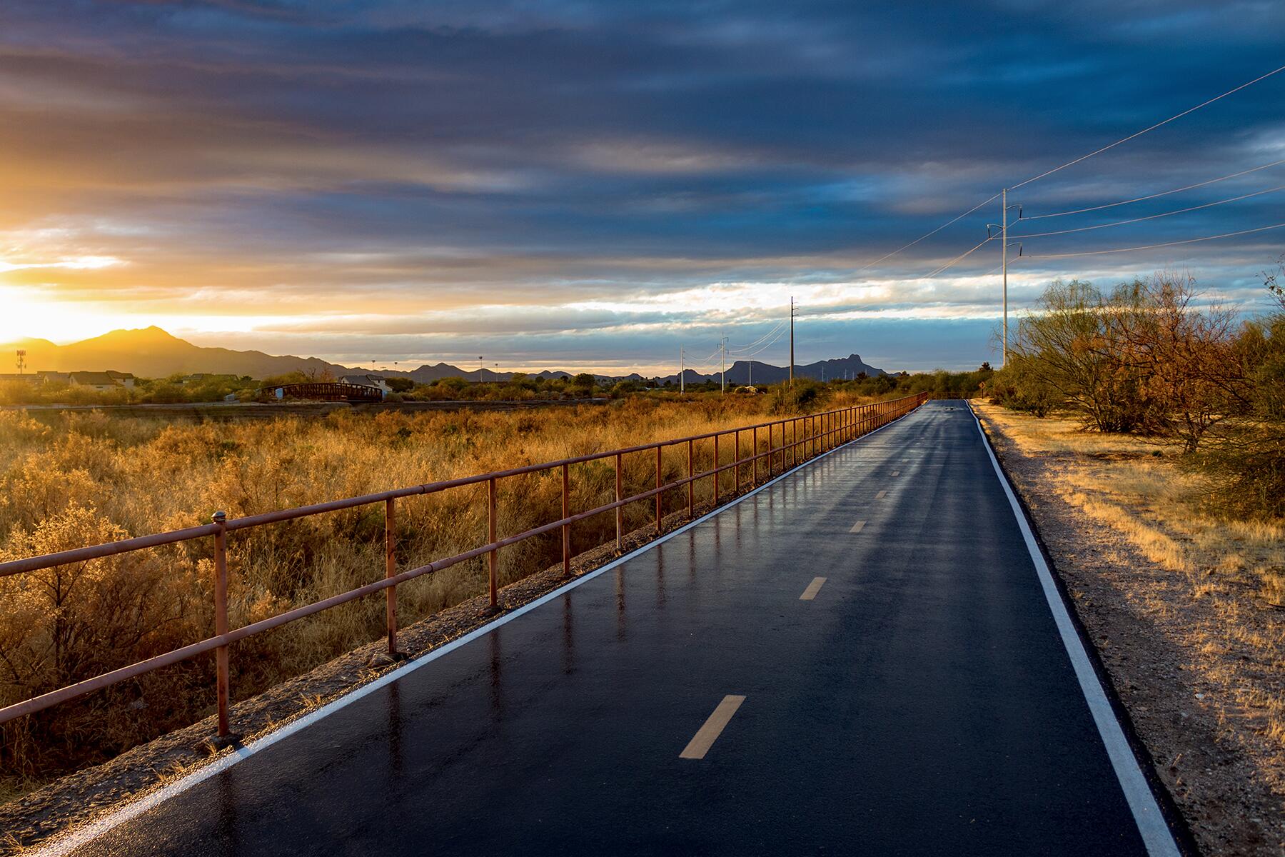
Chuck Huckelberry Loop
WHERE: Tucson, Arizona
What now seems like a masterfully planned 131-mile tour de Tucson open to all people-powered forms of transportation was actually born out of disaster. In 1983, heavy seasonal rains caused calamitous flooding in three typically dry riverbeds. Along the Rillito, Pantano, and Santa Cruz rivers, dirt walls were shored up and maintenance roads were built. Eventually, they opened to recreational use. The city continued to add concrete conduits, bridges, and underpasses. By 2018, they had themselves one massive network of trails connecting 30 public parks, hotels, attractions like the Pima Air and Space Museum (some exhibits live outside), retail, restaurants, BMX tracks, sports fields, farmer’s markets, suburbs, and Saguaro National Park. The east section is urban; the west decorated with art; the north greener and hillier with views of the Catalina range. But the south is what you come for as it’s chock full of cacti, javelinas, and other Sonoran desert delights.
Shark Valley Tram Road
WHERE: Everglades National Park, Florida
Despite the name, it isn’t Jaws you should be worried about bumping into when rolling around this 15.8-mile loop in the Sunshine State’s signature swamp/slow-moving river. They don’t call the region “Alligator Alley” for nothing. You’ll also possibly come across various other beasts of the southern wild like gopher tortoises, a bevy of turtle species, muskrats, centipedes, golden silk orb-weavers, millennial pink roseate spoonbills, nine-banded armadillos, or endangered panthers. Chances of spotting the residents from the road bikers share with hikers and trams increases during the dry season (November through April) when animals are forced to gather at fewer and shrinking watering holes.
INSIDER TIPRangers lead free full-moon bike tours throughout winter months. If you can’t score a slot on the very popular experience, you aren’t entirely out of luck. Although lots close at 6 p.m., the national park itself is technically open 24 hours a day. Leave your car just out of N.P.S. bounds and ride the trail in the pale moonlight solo…if you dare.
Walkway Over the Hudson
WHERE: Poughkeepsie to Highland, New York
Take your hobby to new heights on the world’s longest elevated pedestrian bridge. Perched 212 feet above the Hudson, this linear park and engineering marvel was refashioned in 2009 from the neglected remains of what was once the longest bridge on Earth. About 500,000 visitors stream across it annually to take in the pristine panorama that encompasses the Catskills, historic architecture, Paleozoic escapements, rowers, sailboats, manicured bank parks, and hot air balloons. The short, flat channel is ideal for families and first-timers, but pros can easily keep pedaling. From the Highland side, hook up with the Hudson Valley Rail Trail, which ferries cyclists through a corridor of rock cuts cooled by a leafy canopy past the marshy critter magnet known as Black Creek Preserve all the way to the college town of New Paltz. Or head in the other direction to take a tour of rural radiance as exemplified by the old-timey barns, pastoral countryside, and a memorial mile dedicated to veterans that line the Dutchess Trail. It ends at Hopewell Depot, now a small museum and photo gallery. If you prefer hops to history, look into craft brews-and-bikes programs like the one offered by
Great Allegheny Passage & C&O Canal Towpath
WHERE: Pennsylvania, Maryland, D.C.
Combining these two history-laden bicycle byways allows long haulers to chart a 334-miles course from Pittsburgh to the nation’s capital and in the process they’ll glimpse the Cumberland Narrows, cross the Mason-Dixon Line and the Eastern Continental Divide, navigate several state parks including Ohiopyle, bob along three rivers and the C&O Canal (also a national historical park), top the 101-foot-high Salisbury Viaduct, brave the pitch-black Paw Paw Tunnel (don’t forget a flashlight!), and admire Georgetown’s lovely brick townhouses. The GAP was the first inductee into Rails-to-Trails Conservancy’s Hall of Fame. Cottage industries of feeding and lodging GAP goers have sprung up in the many Industrial Age enclaves that used to be at the heart of coal and steel industries. Go in October to capitalize on prime leaf-peeping opportunities.
National Mall and Memorial Parks
WHERE: Washington, D.C.
Speaking of the federal city, the National Mall, surrounding parklands, the serene Potomac, and assorted, lately controversial, memorials make for a ride, especially when done in March or April during peak cherry blossom bloom, that can only be described as monumental. (We know, groan. We hate ourselves, too.) But dad joke notwithstanding, the praise is far from hyperbolic. Spend an hour in America’s Front Yard and you can log several miles of exercise, critique Rodin and Yayoi Kusama in the sculpture garden of the Hirshhorn, honor fallen heroes, soak up some sun, smell the stinky corpse flowers at the United State Botanic Garden, see where bills are passed and the president lives, and enmesh yourself in the philosophies and triumphs of founding fathers, civil rights activists, deep thinkers, and prestigious leaders. Capital Bike Share has numerous rental stations around the basin.
Trail of the Coeur d’ Alenes
WHERE: Plummer to Mullan, Idaho
Florida isn’t the only state with a panhandle that knows how to party. Idahoans, however, prefer the natural high that can be procured by quality time spent on this 73-mile paved panhandle path that zigzags through the photogenic Silver Valley along Lake Couer d’ Alene and the same-named river all while surrounded by expansive smog-free skies and starter mountains bestrewn with trees. It can be broken up into easily digestible chunks thanks to 20 trailheads and 20 well-kept waysides with picnic tables, parking lots, outhouses, informative kiosks, and benches make rides and rests more comfortable.
Luckily, the fun doesn’t have to stop when winter arrives as segments of the path are groomed for use with fat-tire bikes or snowmobiles.
Katy Trail
WHERE: Machens to Clinton, Missouri
If “go big or go home” is your battle cry, immediately add the Katy, the longest developed rail trail in the country at 240 miles, to your bucket list. A good portion of the Show-Me State stretch, which practically spans the width of the 24th member of the U.S., follows in the footsteps of Lewis & Clark’s 1800s expedition as it winds along the mighty Missouri from Machens to Boonville before shooting south and ending near the shores of another of Missouri’s best water features, Lake of the Ozarks. Some geography—grassy fields, wooded groves, tall limestone cliffs, undeveloped riverbanks—would sill be familiar to the explorers. Stone tunnels and historic bridges aren’t the only reminders of the K-T’s past life in locomotion (the Missouri-Kansas-Texas Railroad, which was nicknamed K-T, or Katy). Restored depots, crossing signals, and other equipment remnants, and even the occasional passenger car pop up here and there.
When the clock strikes wine o’clock, be sure to be near Augusta or Hermann, a hamlet steeped in German-American heritage that can be reached using a three-mile connector bike path, as they make up a bulk of the developing Midwestern wine country. If you prefer antiques to vintages, drop by Rocheport.
Remember when we visit George S. Mickelson Trail, we road from custer to hill city. 16mile one way. this trail is beautiful! we had some great fall views & you can see crazy horse from the trail. the ride back from hill city is slightly more difficult due to the long hill back to crazy horse.