


Mammoth air quality right now??
 Aug 21st, 2020 | 10:35 AM
#1
Original Poster
Joined: Jan 2020
Posts: 30
Likes: 0
Mammoth air quality right now??
We are supposed to drive from the Bay Area to Mammoth tomorrow for a 3 day trip. Our kids were planning on going to the bike park both Sunday and Monday. I'm looking at several websites about the current and projected air quality readings because of all of the fires, but the readings are very different - some indicate it looks safe, and others show unhealthy air quality. Is anyone there right now who can tell me what it's actually like, and can let me know air quality forecast for the next 3-4 days? Driving from the San Francisco Bay Area (Walnut Creek). Thanks in advance.
 Aug 21st, 2020 | 11:49 AM
#2

Joined: Jan 2012
Posts: 12,846
Likes: 26
Air quality shifts with the wind direction. I currently check the forecast, then look out my window, then stick my head out & do a sniff test before deciding when to water the tomatoes. Maybe not the best time for planning outdoor activities with all the ongoing uncertainty. And I wouldn't count on anyone's predictions.
 Aug 21st, 2020 | 12:39 PM
#3


Joined: Jan 2003
Posts: 26,491
Likes: 4
There's a dense smoke advisory right now until mid-day tomorrow. Fairly good chance of rain and thunderstorms on Sunday and Monday.
https://forecast.weather.gov/MapClic...9#.X0AwIMhKg2w
https://forecast.weather.gov/MapClic...9#.X0AwIMhKg2w
Aug 21st, 2020 | 01:37 PM
#4
Joined: Jan 2012
Posts: 12,846
Likes: 26
Or lightening & no rain. And with the lightening the chance of many more fires, which is what started the dozens still uncontained around N. CA now from last weekend, including in places that have never had fires until now, including the Bay Area.
https://readynevadacounty.org/CivicAlerts.aspx?AID=3207
https://readynevadacounty.org/CivicAlerts.aspx?AID=3207
Aug 22nd, 2020 | 08:41 AM
#5
Joined: Jan 2005
Posts: 25,597
Likes: 0
There is no Air Quallty station in Mammoth. Reno is pretty far away and more likely to be impacted by the fires in the Sacramento Delta, etc.. I would look at the Mammoth Mountain cams on their web page.
https://www.mammothmountain.com/
https://www.mammothmountain.com/
Aug 22nd, 2020 | 09:20 AM
#6
Joined: Jul 2004
Posts: 6,339
Likes: 8
This site shows a sensor at Mammoth:
https://fire.airnow.gov/
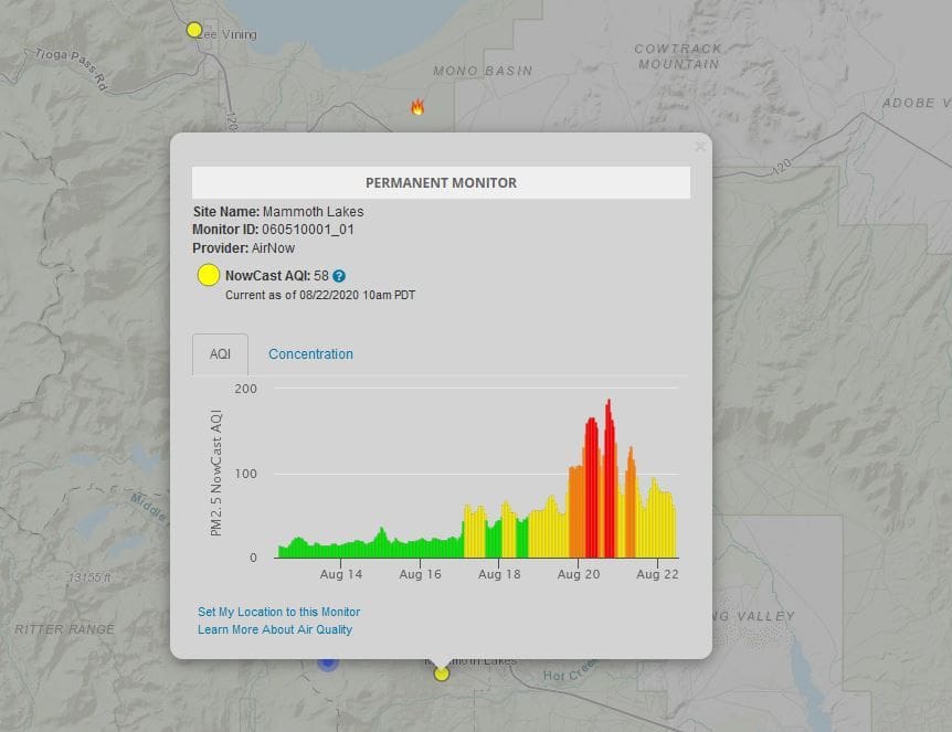
Zooming out to see the western US is a bummer.
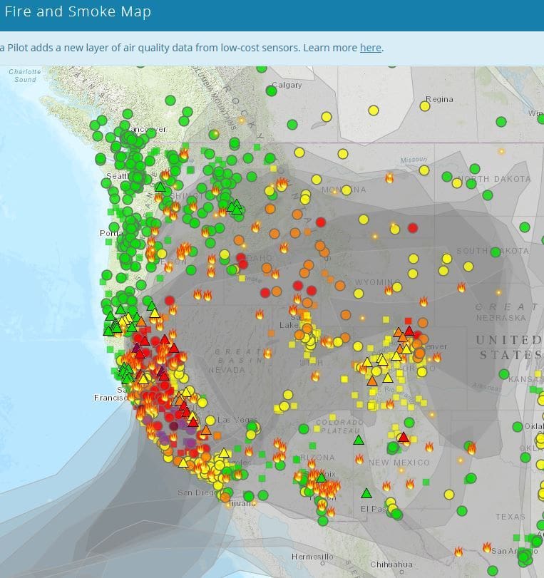
https://fire.airnow.gov/
Zooming out to see the western US is a bummer.
Aug 22nd, 2020 | 09:59 AM
#7
Joined: Jan 2012
Posts: 12,846
Likes: 26
Thanks, Nelson, very interesting! I'll be checking during the day to see what happens to our now red/purple readings. Where my family was & has now evacuated is top of the scale maroon, but where they've gone, not very far away, is green. All depends on the wind, very graphically displayed.
Trending Topics
Aug 22nd, 2020 | 11:54 AM
#9
Joined: Jul 2004
Posts: 6,339
Likes: 8
It's a really useful site, I was alerted to it a few weeks ago.
I'm in Colorado. Two days ago I was talking to a friend about 50 miles away from me. He was enveloped in smoke but it was clear by me. I pulled up the site and that was exactly what it showed, a plume of smoke streaming over his town.
Good luck MmePerdu and CA folks. It looks awful there.
I'm in Colorado. Two days ago I was talking to a friend about 50 miles away from me. He was enveloped in smoke but it was clear by me. I pulled up the site and that was exactly what it showed, a plume of smoke streaming over his town.
Good luck MmePerdu and CA folks. It looks awful there.
Aug 22nd, 2020 | 12:44 PM
#10

Joined: Oct 2005
Posts: 75,007
Likes: 50
Thanks Nelson - that's a brilliant site. One of the permanent monitors is about 5 miles from my home . . . and red it is (at least its not purple). Seems to be a teensy bit better today even though the fires are pretty much uncontrolled.
Aug 26th, 2020 | 06:35 AM
#11
Joined: Nov 2010
Posts: 11,752
Likes: 17
Air quality shifts with the wind direction. I currently check the forecast, then look out my window, then stick my head out & do a sniff test before deciding when to water the tomatoes. Maybe not the best time for planning outdoor activities with all the ongoing uncertainty. And I wouldn't count on anyone's predictions.
Aug 26th, 2020 | 07:22 AM
#13
Joined: Nov 2010
Posts: 11,752
Likes: 17
You can't do the sniff test with a camera. When the smoke got bad this week, I could smell and taste it. So far the USFS trusts my judgement over a camera for detecting and reporting fires. There are a lot less fire lookouts than there were 30+ years ago. Lookouts are fighting the trend of putting cameras on lookout towers and having someone monitor 4 or more screens in a comfy office.
Aug 26th, 2020 | 08:09 AM
#14
Joined: Jan 2003
Posts: 26,491
Likes: 4
In watching the fire.airnow.gov link provided by Nelson (which I'm now doing every day), I was amazed at how many "fires" were detected by satellite. If you really zoom in on the map and hover over the little bull's eye icon, the spread and shape of some events (not all that are perhaps too small) appears. If you double click on the icon, the exact location by latitude/longitude is shown.

Thread
Original Poster
Forum
Replies
Last Post
Fra_Diavolo
United States
9
Nov 14th, 2011 04:35 PM
Sammy
United States
8
Jan 23rd, 2002 03:18 PM
Victor
Europe
6
Feb 9th, 2000 04:40 AM


