


Trip Report: Outback Adventure
 Oct 5th, 2025 | 08:23 PM
#41
Original Poster

Joined: Apr 2004
Posts: 1,147
Likes: 0
Alice Springs, the MacDonnell Ranges and Ormiston Gorge
I'm back! Thanks for the nice comments everyone. I enjoyed your report Peter - our itineraries intersected at a few places like Bourke and Mt Isa. I had been to Longreach, Winton and Barcaldine on a previous trip, a trip that piqued my interest in going further west.
Continuing with our day in and around Alice.....
We ate breakfast the next morning at Fawlty�s in the nearby Todd Mall. Service was friendly and the food was good, but the mall itself was rather generic and outdated. Unlike our hotel, which had Wi-Fi issues, the mall had Wi-Fi, so we were able to catch up with correspondence and plan the day ahead. Among the many to-do options available, we decided to hike Ormiston Gorge in the West MacDonnell Ranges, 135 km (84 mi) west of the city.From Alice, we followed the Larapinta and Namatjira Drives to the gorge turnoff.
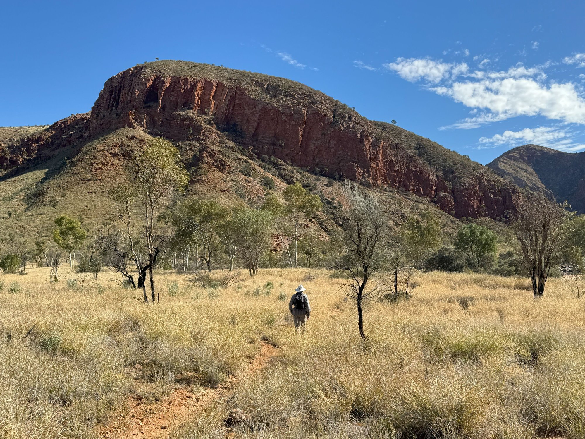
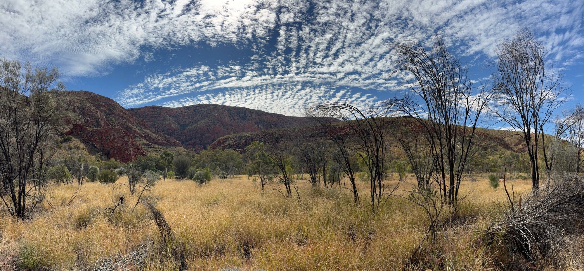
I�d been to the area twice before but had forgotten just how beautiful the route is as it passes between the sandstone escarpments of the West MacDonnells. Given the fine weather and the time of year, Ormiston was a popular spot that day for hikers and campers. Fortunately for us, most people stuck to the easy, short walks that head straight into the gorge or climb to a nearby overlook. We did the 9.5 (5.9 mi) Ormiston Pound Walk, encountering only about dozen other hikers. The walk must be one of the best day hikes in Australia. It is absolutely stunning: gorgeous views into the pound (a ring of escarpments), wildflowers, ghost gums clinging to rock faces, peaceful scenes along a semi-dry river (Ormiston Creek) leading into the steep gorge strewn with pink boulders and shallow pools. Part of the walk follows a section of the famed Larapinta Trail that extends 231 km (144 mi) west from Alice through the MacDonnell Ranges to Mt. Sonder. The Pound Walk is rated moderate in difficulty � a modest climb for the first few k�s, a decent to the river and scrambling among boulders and wading through shallow water towards the end.
It was late afternoon as we negotiated our way out of the gorge, its walls glowing red in the waning sunlight. In preparation for the next day�s long drive to south to Coober Pedy, we fueled up in Alice � diesel at a petrol station, beer and wine at a �grog shop� near our hotel. The security at the liquor store was surprising � police outside checking lDs that were re-checked in the store. The same was true at the bar (Bojangles Saloon and Restaurant) where we ate a hearty steak dinner. Sadly, it appeared that most of the people being turned away outside the bar were Aboriginals, I presume (or hope) due to public drunkenness rather than racial profiling.
It had been about 25 years since I last visited Alice Springs. Memories of the city then are vague, but I couldn�t help thinking it has gone downhill during that time. I�m guessing that construction of Yulara and the expansion of the airport at Uluru (Ayers Rock) hasn�t helped: international visitors to Australia, especially those doing the Sydney-Reef-Rock circuit, can now conveniently give Alice a pass. It�s a shame really, because The Red Center has so much to offer, not only the gorges we visited - Ormiston and Trephina � but several other beautiful gorges, Simpson�s Gap, Standley Chasm, Palm Valley, Kings Canyon and Gosse�s Bluff, the latter being the crater remnant of an ancient meteorite impact.
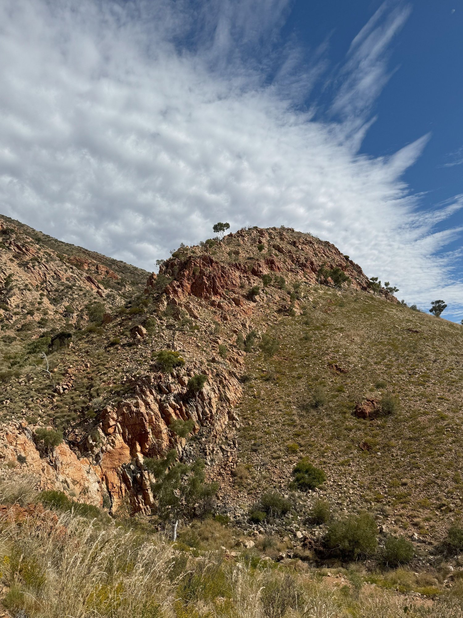
From the car park we climbed to the top of this ridge for a view into the Pound
Nearing the top of the ridge

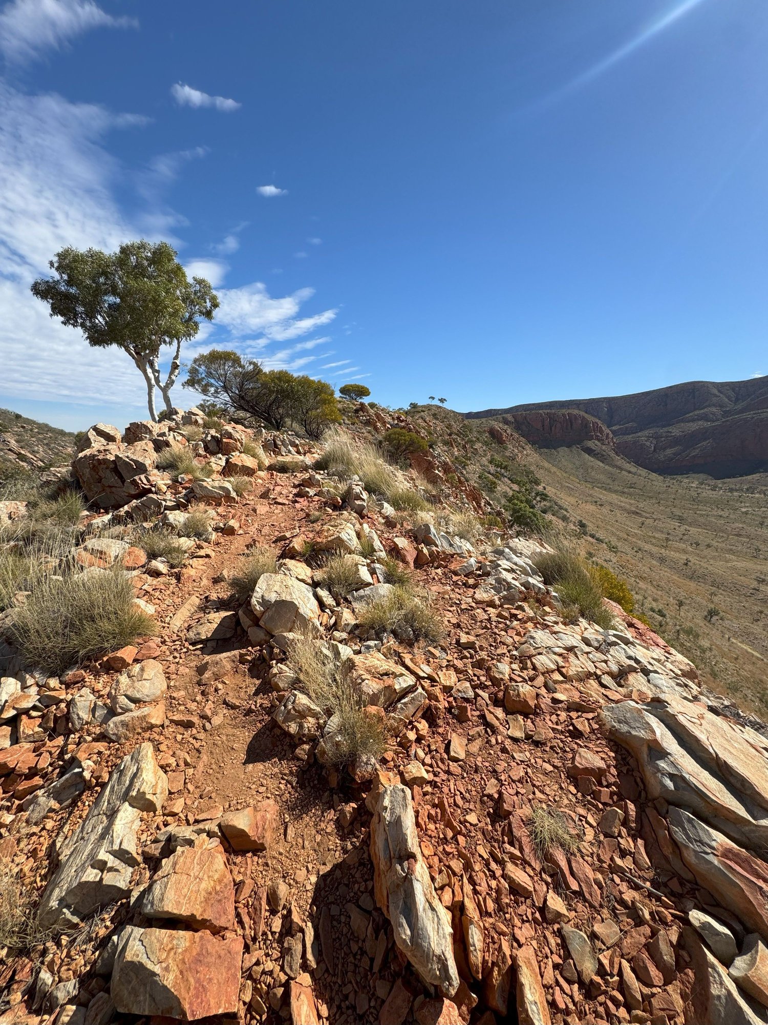
Looking back down the ridge into the Pound
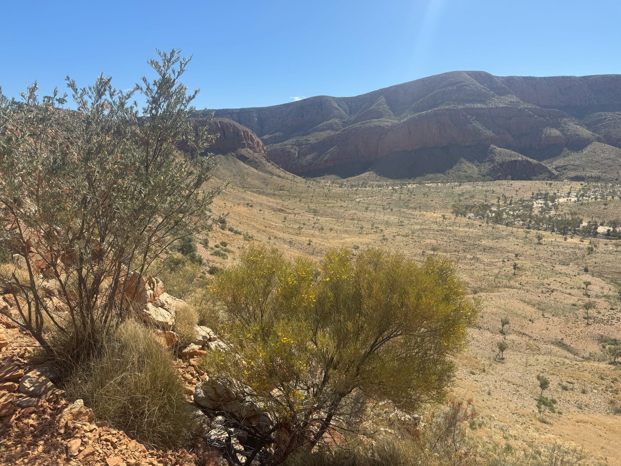
Looking down at the Ormiston Creek that winds its way into the gorge on the left
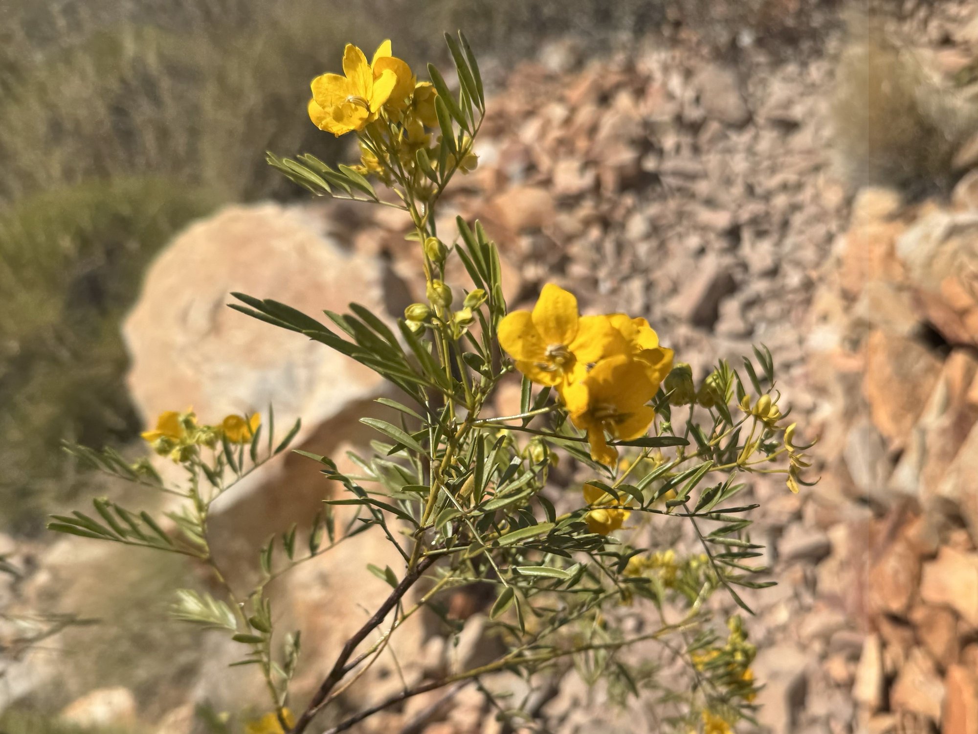
Lots of wildflowers of different kinds along the way

Ralph descending to the floor of the Pound

Approaching the creek

Ormiston Creek
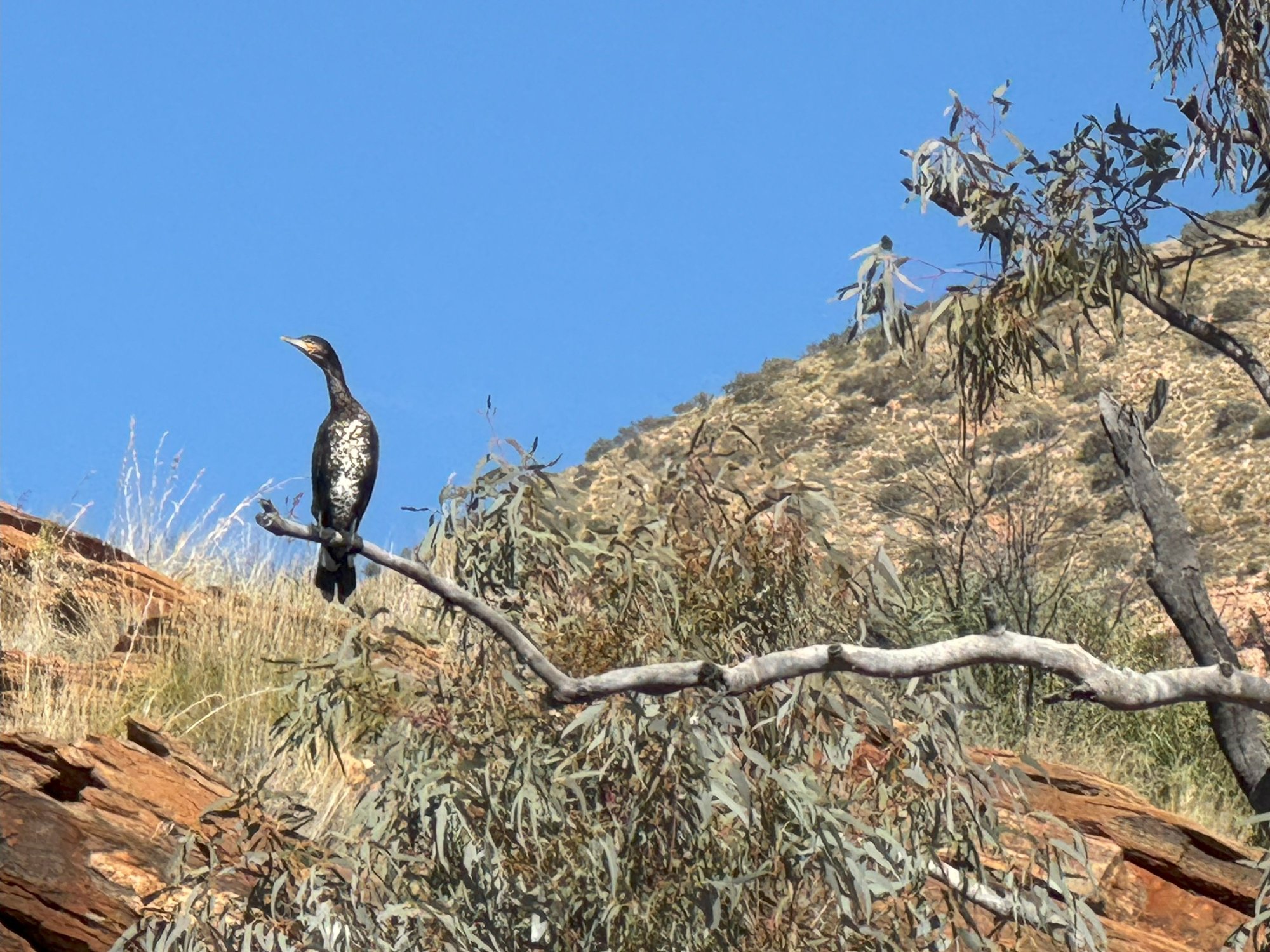
Cormorant surveying the creek
A lonely Dave leading the way
Beautiful clouds!

As chemists, these flowers reminded us of test tube cleaners

Getting closer to the gorge

Getting real close!

Stunning reflections

The gorge walls looked as if they'd been made by giant bricks
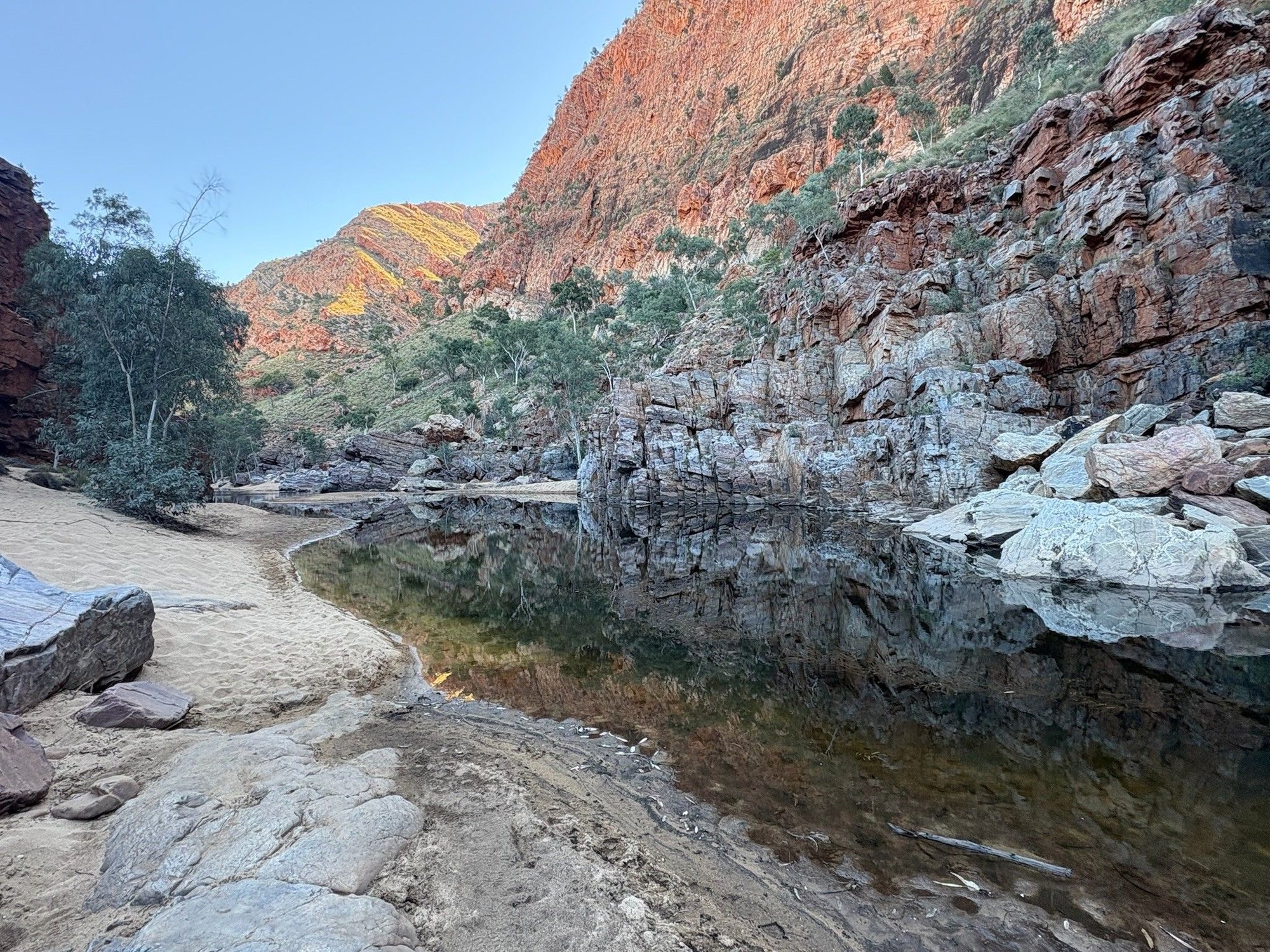
More reflections

We had to wade in a couple of places. Fortunately we didn't have to get our clothes wet.
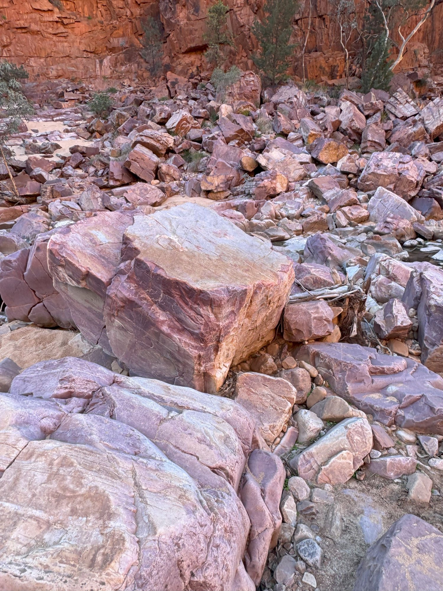
Pink boulders for the last 1 km or so.

Looking up the gorge at the end. What a fantastic hike!!!
Continuing with our day in and around Alice.....
We ate breakfast the next morning at Fawlty�s in the nearby Todd Mall. Service was friendly and the food was good, but the mall itself was rather generic and outdated. Unlike our hotel, which had Wi-Fi issues, the mall had Wi-Fi, so we were able to catch up with correspondence and plan the day ahead. Among the many to-do options available, we decided to hike Ormiston Gorge in the West MacDonnell Ranges, 135 km (84 mi) west of the city.From Alice, we followed the Larapinta and Namatjira Drives to the gorge turnoff.
I�d been to the area twice before but had forgotten just how beautiful the route is as it passes between the sandstone escarpments of the West MacDonnells. Given the fine weather and the time of year, Ormiston was a popular spot that day for hikers and campers. Fortunately for us, most people stuck to the easy, short walks that head straight into the gorge or climb to a nearby overlook. We did the 9.5 (5.9 mi) Ormiston Pound Walk, encountering only about dozen other hikers. The walk must be one of the best day hikes in Australia. It is absolutely stunning: gorgeous views into the pound (a ring of escarpments), wildflowers, ghost gums clinging to rock faces, peaceful scenes along a semi-dry river (Ormiston Creek) leading into the steep gorge strewn with pink boulders and shallow pools. Part of the walk follows a section of the famed Larapinta Trail that extends 231 km (144 mi) west from Alice through the MacDonnell Ranges to Mt. Sonder. The Pound Walk is rated moderate in difficulty � a modest climb for the first few k�s, a decent to the river and scrambling among boulders and wading through shallow water towards the end.
It was late afternoon as we negotiated our way out of the gorge, its walls glowing red in the waning sunlight. In preparation for the next day�s long drive to south to Coober Pedy, we fueled up in Alice � diesel at a petrol station, beer and wine at a �grog shop� near our hotel. The security at the liquor store was surprising � police outside checking lDs that were re-checked in the store. The same was true at the bar (Bojangles Saloon and Restaurant) where we ate a hearty steak dinner. Sadly, it appeared that most of the people being turned away outside the bar were Aboriginals, I presume (or hope) due to public drunkenness rather than racial profiling.
It had been about 25 years since I last visited Alice Springs. Memories of the city then are vague, but I couldn�t help thinking it has gone downhill during that time. I�m guessing that construction of Yulara and the expansion of the airport at Uluru (Ayers Rock) hasn�t helped: international visitors to Australia, especially those doing the Sydney-Reef-Rock circuit, can now conveniently give Alice a pass. It�s a shame really, because The Red Center has so much to offer, not only the gorges we visited - Ormiston and Trephina � but several other beautiful gorges, Simpson�s Gap, Standley Chasm, Palm Valley, Kings Canyon and Gosse�s Bluff, the latter being the crater remnant of an ancient meteorite impact.
From the car park we climbed to the top of this ridge for a view into the Pound
Nearing the top of the ridge
Looking back down the ridge into the Pound
Looking down at the Ormiston Creek that winds its way into the gorge on the left
Lots of wildflowers of different kinds along the way
Ralph descending to the floor of the Pound
Approaching the creek
Ormiston Creek
Cormorant surveying the creek
A lonely Dave leading the way
Beautiful clouds!
As chemists, these flowers reminded us of test tube cleaners
Getting closer to the gorge
Getting real close!
Stunning reflections
The gorge walls looked as if they'd been made by giant bricks
More reflections
We had to wade in a couple of places. Fortunately we didn't have to get our clothes wet.
Pink boulders for the last 1 km or so.
Looking up the gorge at the end. What a fantastic hike!!!
Last edited by RalphR; Oct 5th, 2025 at 08:39 PM.

 Oct 9th, 2025 | 02:22 PM
#45
Joined: Oct 2007
Posts: 16,515
Likes: 4
Hi Ralph,
Some of your photos sprung off my screen like Albert Namatjira paintings. You may know about this wonderful Aboriginal artist but if not, here's a link that I think might just pique your interest.
https://en.wikipedia.org/wiki/Albert_Namatjira
There's some more colourful & interesting links but I couldn't get rid of the ads - worth a look on Google to see what you can find.
Oct 24th, 2025 | 08:31 AM
#46
Original Poster
Joined: Apr 2004
Posts: 1,147
Likes: 0
Hi Bokhara - Thanks! Yes, I am quite familiar with Namatjira and the style of landscape painting he pioneered. Saw a few of his originals at the Art Museum of South Australia when we were in Adelaide. Beautiful work!
Ralph
Ralph
Oct 26th, 2025 | 09:15 AM
#47
Original Poster
Joined: Apr 2004
Posts: 1,147
Likes: 0
Alice Springs to Coober Pedy
After two nights in Alice Springs, we headed south on the Stuart Hwy toward the famous opal mining town of Coober Pedy (CP). This was the longest stretch we drove in one day � about 700 kms (430 miles), almost all bitumen except for the sightseeing detour me made near the end. The terrain was similar terrain to what we had seen the previous few days: generally flat with red soil, scattered shrubs, occasional hills and rock outcroppings. Nearer CP the landscape slowly became more lunar, or better, more Martian in appearance: seemingly drier with less green vegetation. Interestingly, roadkill was minimal, unlike the kangaroo slaughter we had seen in Queensland and saw later driving across New South Wales.
We passed the turn off to Uluru and Kata Tjuta on the Lasseter Hwy. It was tempting to make the turn to visit again, but keeping to the plan, we continued straight, crossing the border into the state of South Australia within about three hours of leaving Alice. Lunch was chili and hot dogs heated up at a rest stop part way. A road train parked there had windows reflectively shaded and engine running � naptime, I guess. About 20 kms north of CP we made a left turn on an unsealed road to a viewpoint overlooking the Breakaways, wind-carved sedimentary formations on the desert edge. Our timing late in the day was perfect for enjoying the view. I didn�t realize at the time that the Breakaways were the backdrop for one of the Outback scenes in Priscilla Queen of the Desert, an Australian movie I had seen years ago and rewatched after returning to the States.
Continuing the detour, we stopped for a close-up look at the Dog Fence, purportedly the world�s longest fence, which winds across South Australia, New South Wales and Queensland for some 5600 km (3500 mi). Fascinating, since I remembered seeing a part of the same fence while visiting a friend�s property in Queensland, far to the east, back in the 90�s. Its purpose is to keep dingoes out of the more fertile sheep country to the south.
It was nearly dark by the time we reached our night�s accommodation at the Opal Inn Hotel Motel in CP. This motel was above ground, not excavated into a hill like the more upscale Desert Cave Hotel and other overnight options. Since Coober Pedy is a cultural melting pot with sizeable Italian, Serbian, Greek and other European immigrant communities, it was not surprising there was an Italian Club just up the road. We had hoped for some lasagna and some live music, but it was film night with limited menu options. Nonetheless, we sat down for a beer before heading back to eat at the motel. Dinner there turned out great � surprisingly good chili shrimp, spaghetti and a complimentary schooner of beer. The friendly waitress was yet another European working her 88 days in the Outback to earn a visa extension.
In the morning, we ate a nice granola breakfast with flat white coffees at the nearby Desert Cave Hotel, the place my wife and I stayed while visiting CP in 2006. There, we engaged in a pleasant conversation with a table of Sydneysiders, one of which was only a couple of years behind my wife at Randwick High School in Sydney. Dave and I then explored the hotel and its excellent subterranean exhibition of historical photographs and graphics explaining the processes of opal mining.
Before fueling up for the next sector, we drove up to the Central Lookout for an expansive view over the town: houses (�dugouts�) and businesses dug into the sides of hills to avoid the summer heat, large piles of white-ish rock (mullock heaps) strewn across the landscape looking like anthills from afar. We also stopped at the welcome sign at the south end of town featuring above it a blower truck used in the opal extraction process.
Then it was eastward on the unsealed William Creek Road heading toward the Oodnadatta Track and the town of Maree.
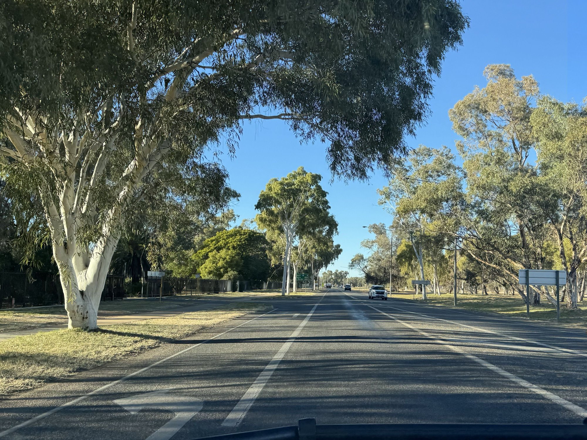
Pretty boulevard leaving Alice, heading south

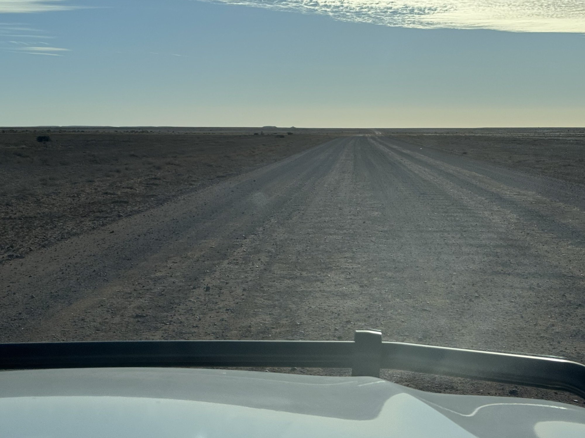
Pretty much the view for 400 miles!
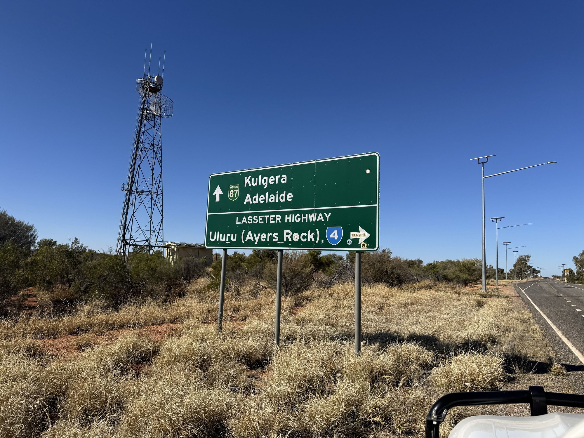
Most tourists would be turning right here. It was tempting, but we'd been before.
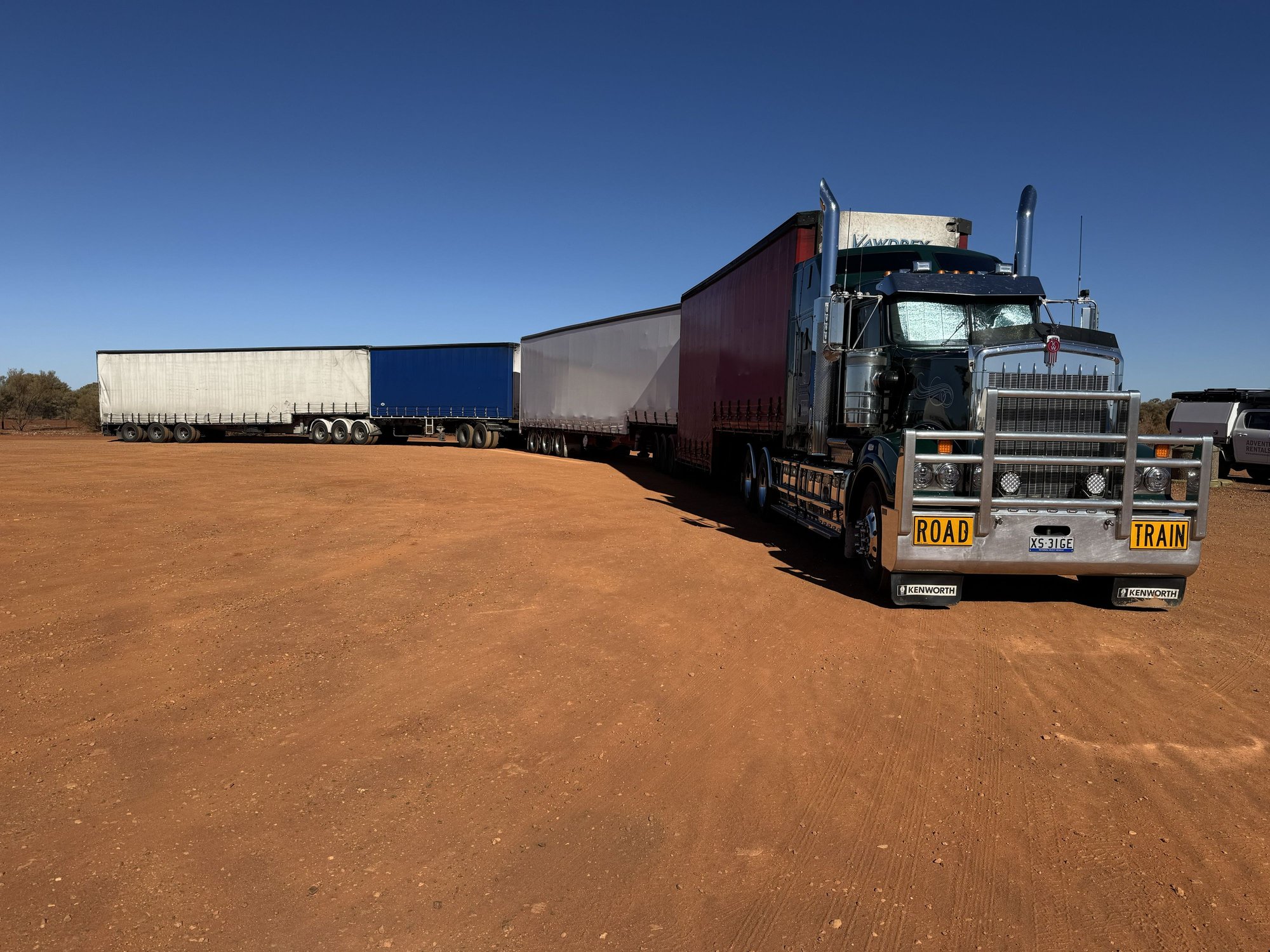
Road train rest stop. Engine was running and the windows were shaded so would assume the driver was having a nap

The Breakaways, outside Coober Pedy

More Breakaways: "Salt and Pepper"

Martian landscape

The 3500 mile-long Dog Fence

Coober Pedy sign with �blower" - basically a vacuum cleaner used to pull opal-bering rocks and dirt out of opal mines

Entering Coober Pedy

Coober Pedy from the Central Lookout

Zillions of these mullock piles around the town, each one adjacent to an opal mine hole

The exhibition at the Desert Sands Hotel. My wife and I stayed there in 2006 - darkest room we've ever slept in!

A "dugout" - one of many houses and businesses in Coober Pedy excavated to escape the extreme desert heat
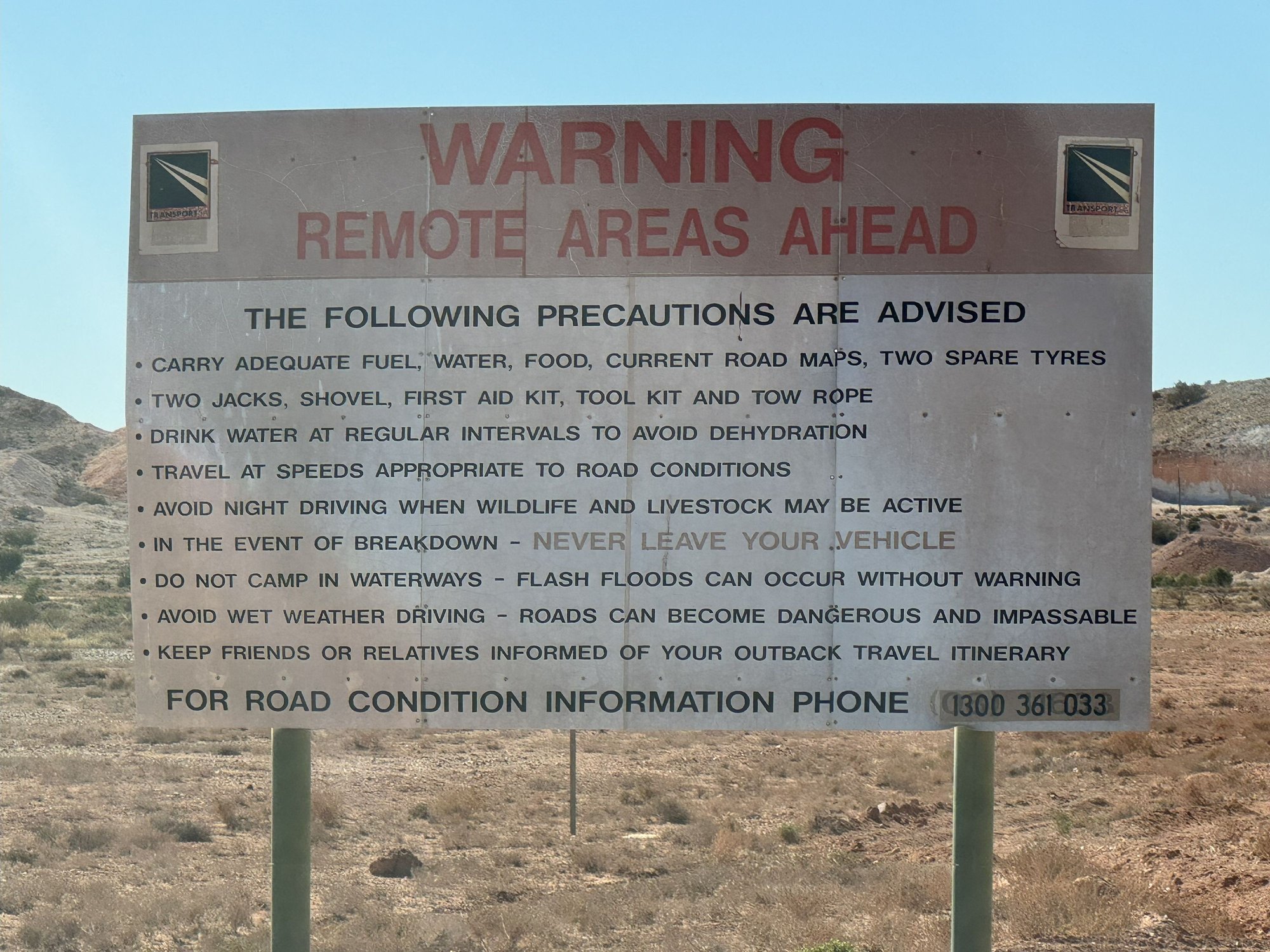
Leaving Coober Pedy: warning on the William Creek Road. We were prepared!
We passed the turn off to Uluru and Kata Tjuta on the Lasseter Hwy. It was tempting to make the turn to visit again, but keeping to the plan, we continued straight, crossing the border into the state of South Australia within about three hours of leaving Alice. Lunch was chili and hot dogs heated up at a rest stop part way. A road train parked there had windows reflectively shaded and engine running � naptime, I guess. About 20 kms north of CP we made a left turn on an unsealed road to a viewpoint overlooking the Breakaways, wind-carved sedimentary formations on the desert edge. Our timing late in the day was perfect for enjoying the view. I didn�t realize at the time that the Breakaways were the backdrop for one of the Outback scenes in Priscilla Queen of the Desert, an Australian movie I had seen years ago and rewatched after returning to the States.
Continuing the detour, we stopped for a close-up look at the Dog Fence, purportedly the world�s longest fence, which winds across South Australia, New South Wales and Queensland for some 5600 km (3500 mi). Fascinating, since I remembered seeing a part of the same fence while visiting a friend�s property in Queensland, far to the east, back in the 90�s. Its purpose is to keep dingoes out of the more fertile sheep country to the south.
It was nearly dark by the time we reached our night�s accommodation at the Opal Inn Hotel Motel in CP. This motel was above ground, not excavated into a hill like the more upscale Desert Cave Hotel and other overnight options. Since Coober Pedy is a cultural melting pot with sizeable Italian, Serbian, Greek and other European immigrant communities, it was not surprising there was an Italian Club just up the road. We had hoped for some lasagna and some live music, but it was film night with limited menu options. Nonetheless, we sat down for a beer before heading back to eat at the motel. Dinner there turned out great � surprisingly good chili shrimp, spaghetti and a complimentary schooner of beer. The friendly waitress was yet another European working her 88 days in the Outback to earn a visa extension.
In the morning, we ate a nice granola breakfast with flat white coffees at the nearby Desert Cave Hotel, the place my wife and I stayed while visiting CP in 2006. There, we engaged in a pleasant conversation with a table of Sydneysiders, one of which was only a couple of years behind my wife at Randwick High School in Sydney. Dave and I then explored the hotel and its excellent subterranean exhibition of historical photographs and graphics explaining the processes of opal mining.
Before fueling up for the next sector, we drove up to the Central Lookout for an expansive view over the town: houses (�dugouts�) and businesses dug into the sides of hills to avoid the summer heat, large piles of white-ish rock (mullock heaps) strewn across the landscape looking like anthills from afar. We also stopped at the welcome sign at the south end of town featuring above it a blower truck used in the opal extraction process.
Then it was eastward on the unsealed William Creek Road heading toward the Oodnadatta Track and the town of Maree.
Pretty boulevard leaving Alice, heading south
Pretty much the view for 400 miles!
Most tourists would be turning right here. It was tempting, but we'd been before.
Road train rest stop. Engine was running and the windows were shaded so would assume the driver was having a nap
The Breakaways, outside Coober Pedy
More Breakaways: "Salt and Pepper"
Martian landscape
The 3500 mile-long Dog Fence
Coober Pedy sign with �blower" - basically a vacuum cleaner used to pull opal-bering rocks and dirt out of opal mines
Entering Coober Pedy
Coober Pedy from the Central Lookout
Zillions of these mullock piles around the town, each one adjacent to an opal mine hole
The exhibition at the Desert Sands Hotel. My wife and I stayed there in 2006 - darkest room we've ever slept in!
A "dugout" - one of many houses and businesses in Coober Pedy excavated to escape the extreme desert heat
Leaving Coober Pedy: warning on the William Creek Road. We were prepared!
Last edited by RalphR; Oct 26th, 2025 at 10:00 AM.
Nov 2nd, 2025 | 05:22 AM
#49

Joined: Jan 2003
Posts: 21,148
Likes: 83
Ralph, just now catching up with your report as we've been traveling as well.
We really enjoyed our trip to Coober Pedy several years ago and you've brought back some fond memories. We still talk about how surprised we were to find good Greek food in Coober Pedy! It remains one of the most unique places we've visited on a rather long list of unique places.
We really enjoyed our trip to Coober Pedy several years ago and you've brought back some fond memories. We still talk about how surprised we were to find good Greek food in Coober Pedy! It remains one of the most unique places we've visited on a rather long list of unique places.
 Nov 3rd, 2025 | 07:18 AM
#50
Joined: Mar 2003
Posts: 6,205
Likes: 0
What Northie said, Wow!!! Your report and photos are spectacular! You visited so many interesting places, and I appreciate seeing these places through your eyes. Coober Pedy is definitely unique and one of a kind. I admit, though, that I am a scaredy cat, and I probably would have turned around and headed back to civilization once I saw the warning sign.
Dec 16th, 2025 | 01:27 PM
#51
Original Poster
Joined: Apr 2004
Posts: 1,147
Likes: 0
Coober Pedy to Marree, South Australia
(Thanks Karen, Mel, northie for your nice comments. I'd better get going with this report since there's still two weeks to go!)
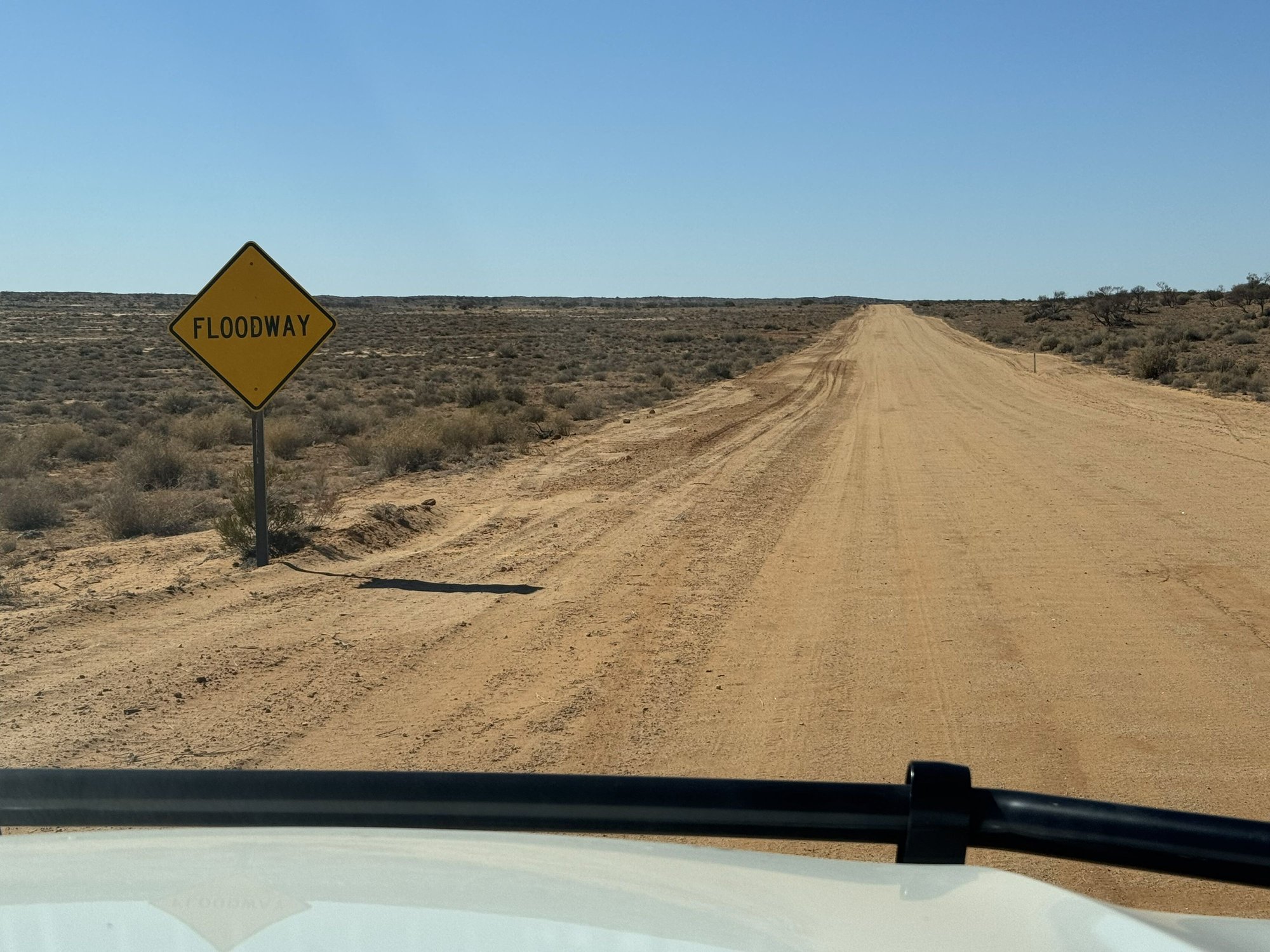
The William Creek Road would have been a bad place to run out gas, not just for its arid treeless moonscape but for the fact we didn’t see another vehicle the whole one hundred miles until its junction with the likewise unpaved Oodnadatta Track. We took a right at the junction to head southeast and shortly passed through the tiny town of William Creek, population about 20. Of course it had a pub, but it also had a golf course – dead flat, four par three holes, with dirt “greens” sprayed that color for effect. No one was playing even though it was free. Obviously, it was put there for a laugh, and that we did.
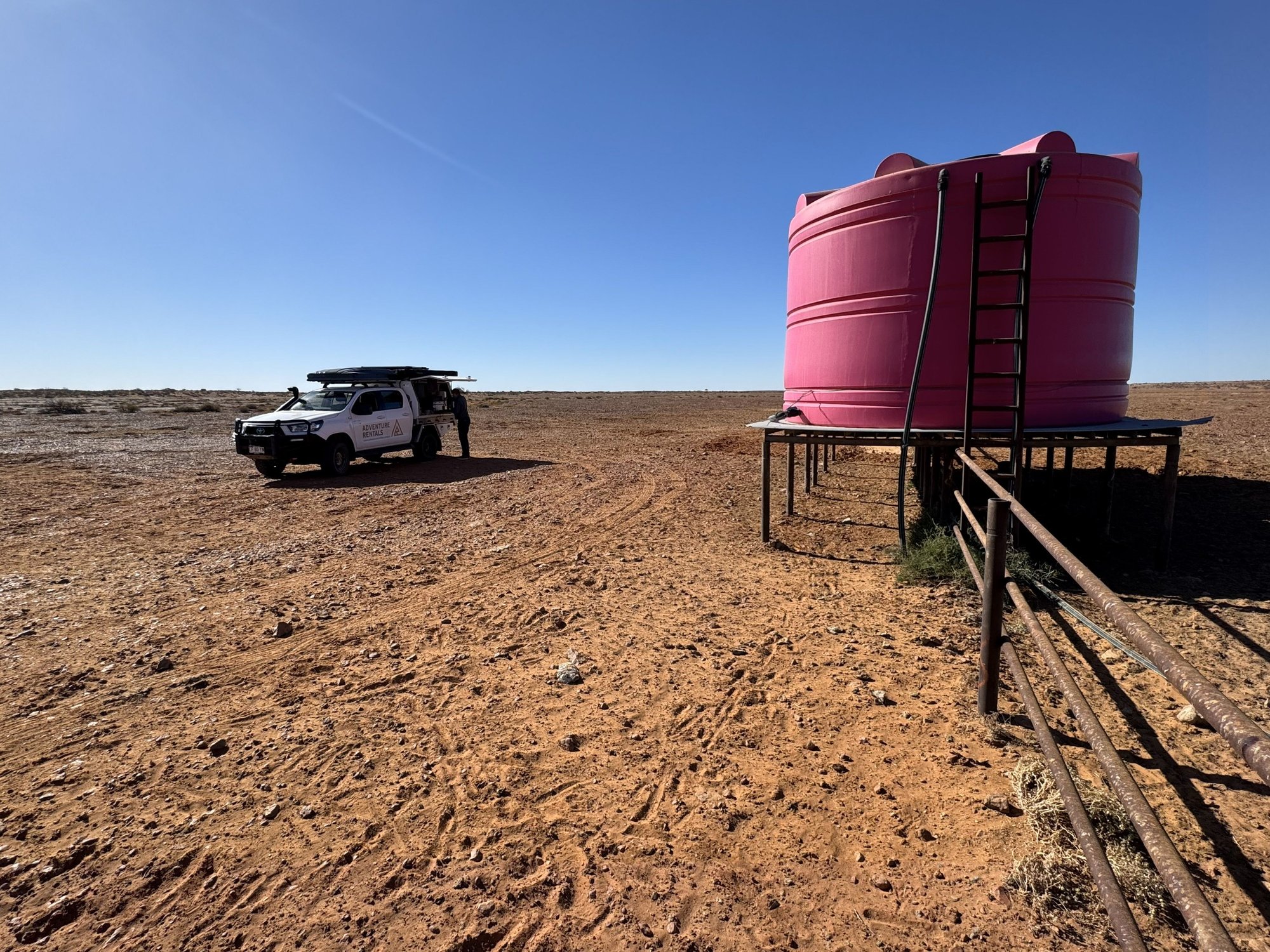
At some point on the Track we pulled over for lunch next to two enormous plastic water tanks that fed water into a cattle trough. I presume they were for cattle because we didn’t see any, and besides it didn’t look like there was anything for them to eat as this was undoubtedly the most desolate place on the planet I think we’d ever been to, let alone had stopped for lunch.
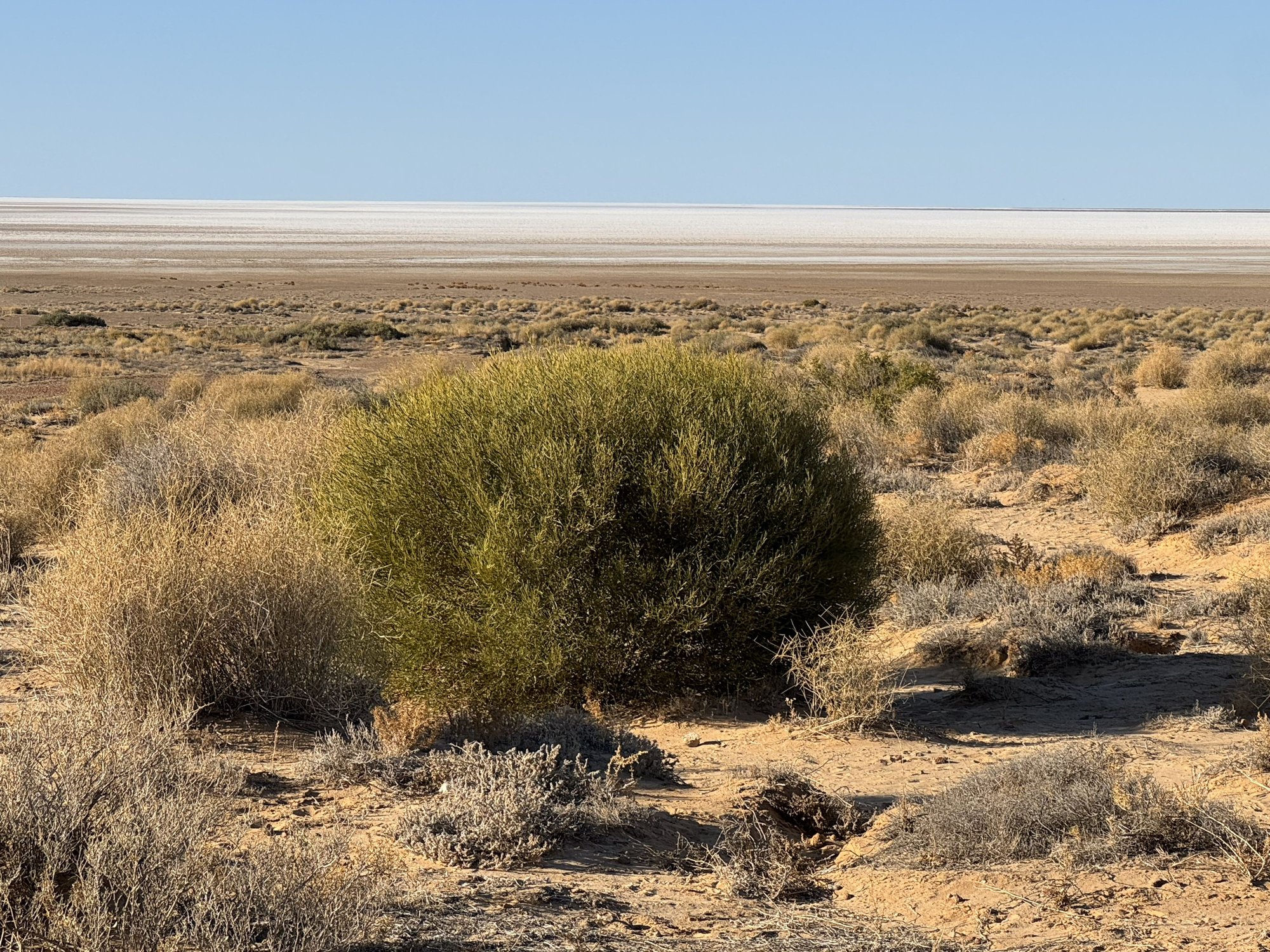
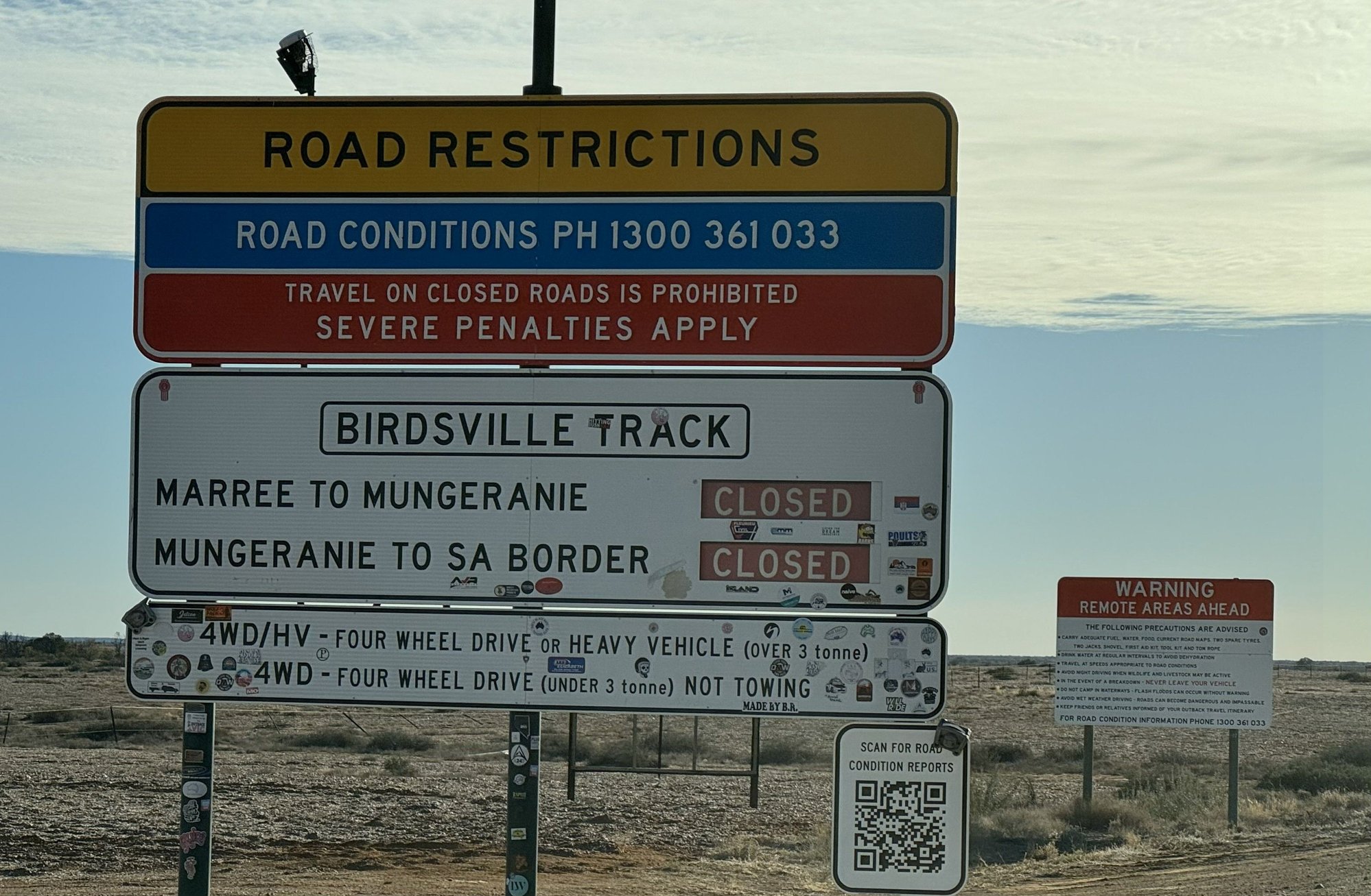
Further along reaching the top of a rise, we encountered a lookout to the north with a view to the distant south shore of Lake Eyre South. At this time, as it is most of the time, the lake was dry, just a thin line of salty white along the horizon. However, we later learned the lake was expected to fill up in a few weeks, thanks to the floodwater deposited in Queensland a few months earlier – the same water that had filled Lake Eyre North and flooded the Birdsville Track forcing us to make last minute itinerary changes.
We didn’t realize it at the time (that is until we took a sightseeing flight over Lake Eyre the next day), that the section of the Oodnadata Track we were on follows the path of the old Ghan Railway that once connected Alice Springs to Port Augusta on Australia’s south coast. That explained the handful of seemingly odd elevated black rectangular tanks and abandoned brick buildings we saw on the right-hand side along way. Even stranger was a sculpture park (now I appreciate being the Mutonia Sculpture Park) featuring, among other weird creations, a pair of white aircraft sticking from the desert nose-up, wing-to-wing.
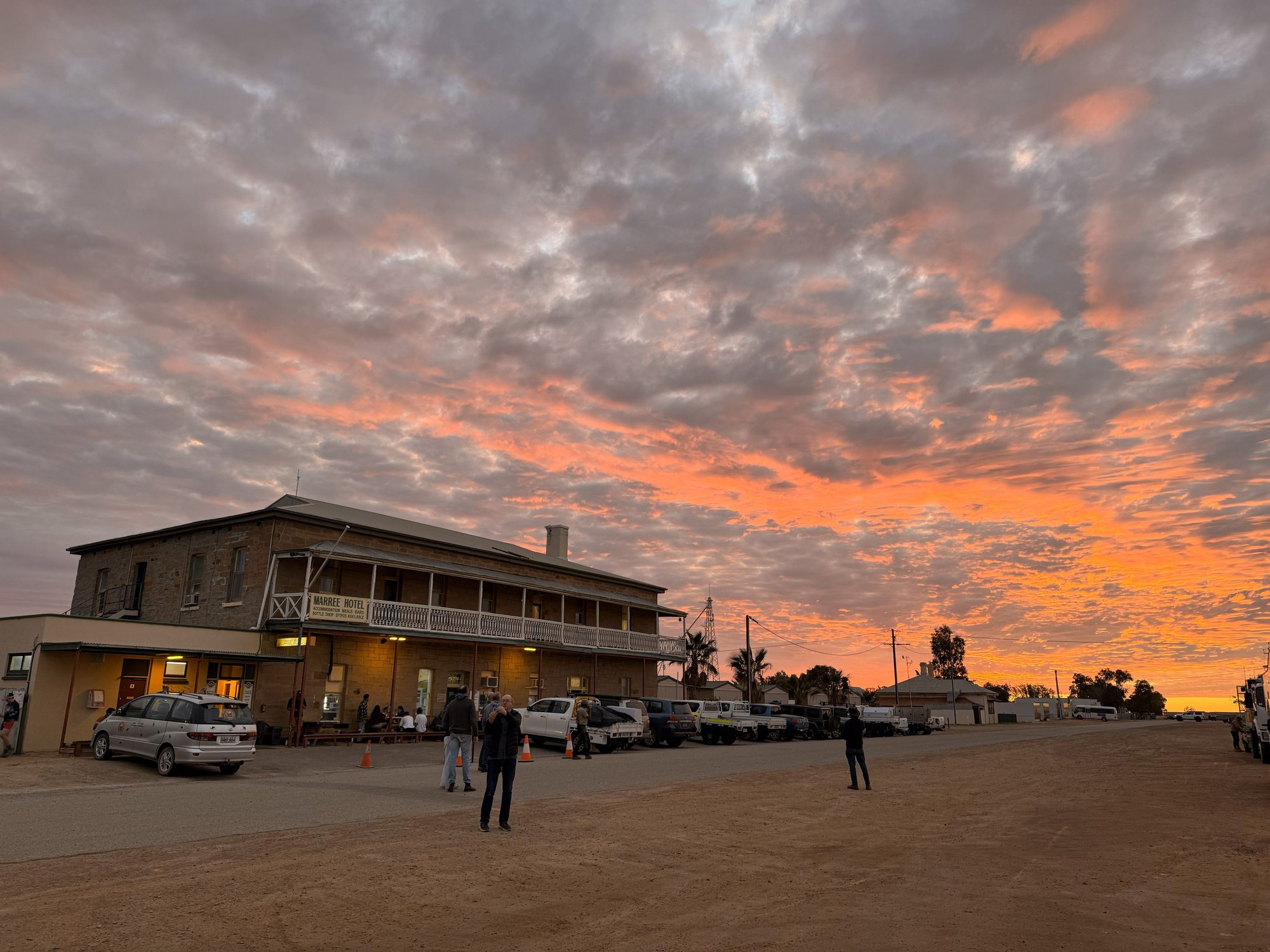
We arrived in Marree shortly before sunset. One of the first buildings we passed warranted a stop for a photo – The Lake Eyre Yacht Club. Like the William Creek golf course and the “MacDonalds: only 721 km” sign we’d seen the week before on the Urandangi Road, we surmised this to be another mischievously ironic monument to the isolation and dryness of the Outback. But, as we soon learned, it really was a yacht club, albeit one that sprung to life once a decade or so when Lake Eyre actually has water in it - as it had when we were there.
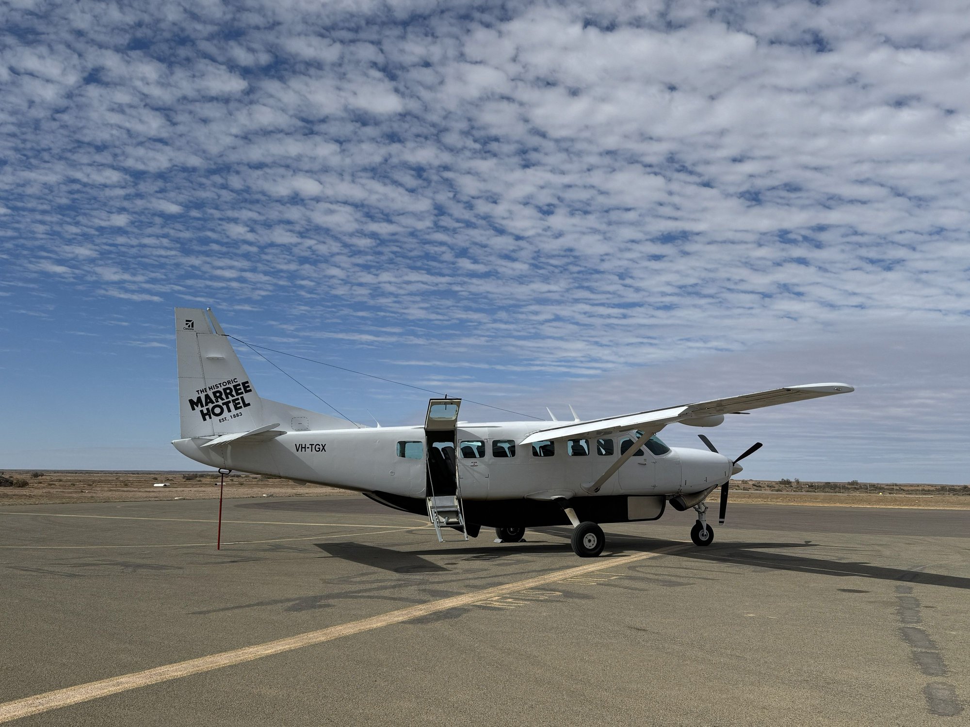
In Marree, we stayed at the charming, historic Marree Hotel. I’m not sure there was any other choice, but even though we were put up in the overflow accommodation (essentially a shipping container with two beds and a bathroom), we were still quite comfortable and loved our experience there – eating, drinking and socializing – over the next two nights. The hotel was doing a roaring trade with a wave of outsiders like us in town to see Lake Eyre in rare flood on scenic flights from the nearby airfield on Arid Air.
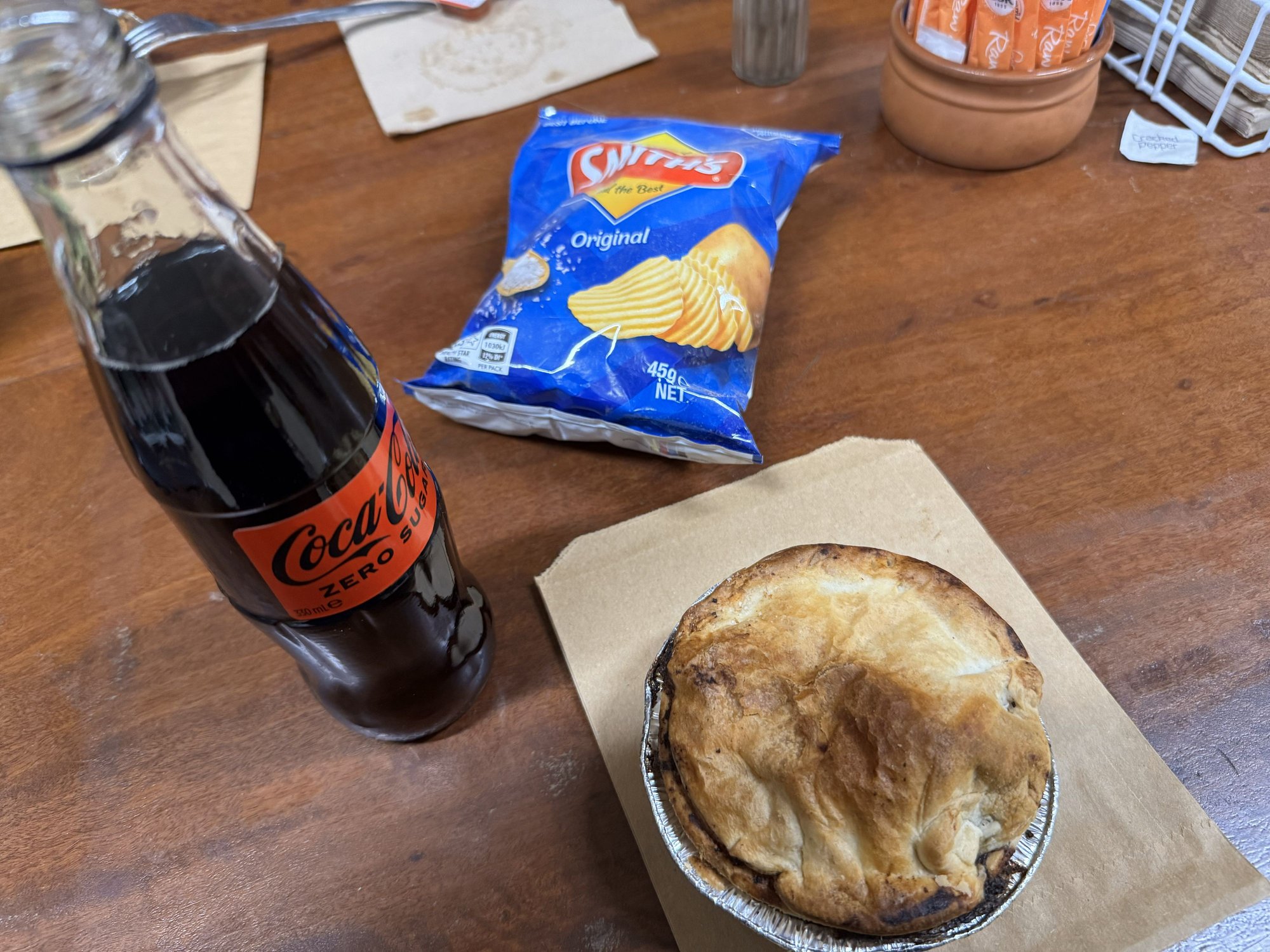
The meals at the Marree Hotel were great – for me that was goat curry and, of course a few beers...and then a few more beers outside standing chatting with other travelers and hotel staff around a large barrel-cum-fire pit that, besides the bar, was a popular gathering spot. Considering it was a busy time of year even without the attraction of a flooded Lake Eyre, the hotel management had hired a sizeable staff, many being young foreigners doing their 88 day visa extension stint. We partied with some of them quite late, even dancing, I think. It’s all a blur to me now!
William Creek Road. Water - here???? Really?
Lunch on the Oodnadatta Track
Lake Eyre South from the Oodnadatta Track
We didnt realize it at the time but these were water tanks that used to service the (Old) Ghan Railway, now ripped up and abandoned.

Weird airplane sculpture adjacent to the Old Ghan Railway

Thought this was a joke at first. But in the very occassional instances when Lake Eyre fills, they actually sail on it, or at least they used to.
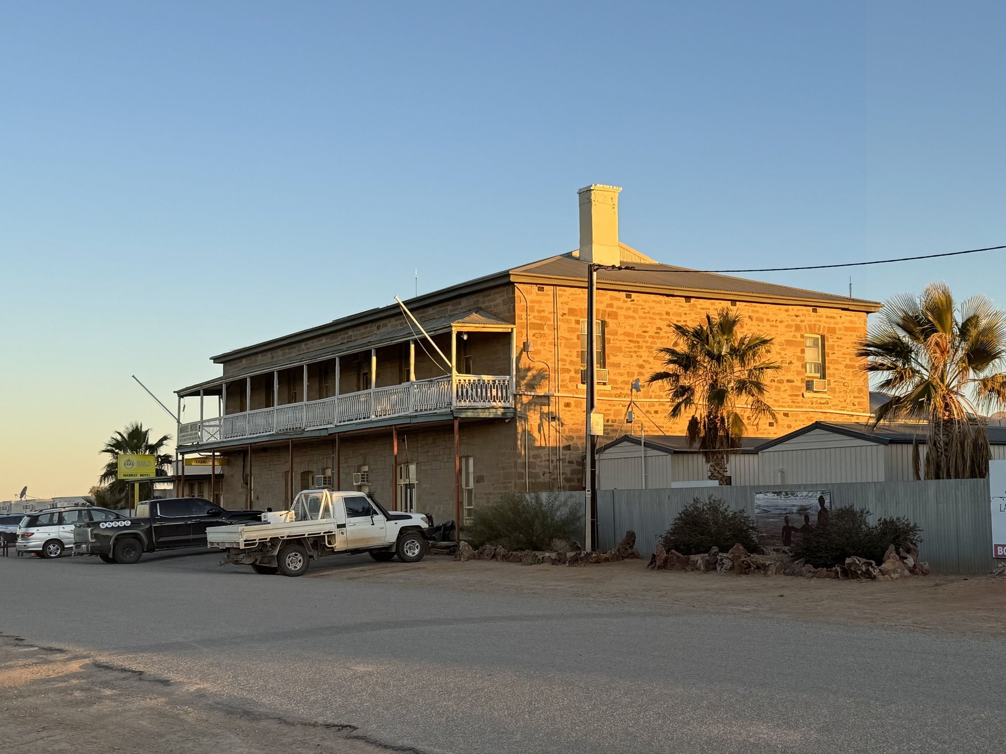
The Marree Hotel. Two fun nights here!
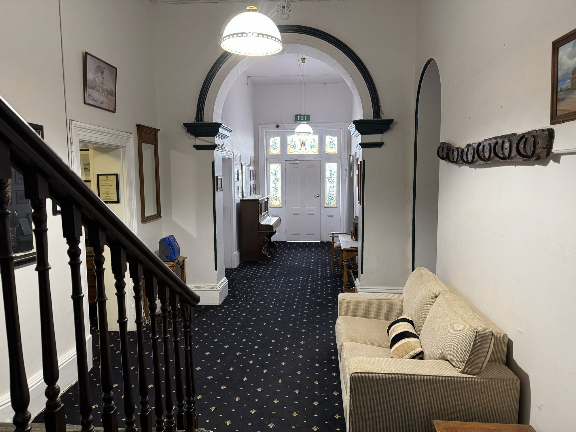
The lovely Victorian foyer. Unfortunately we ended up in the overflow accommodation next door.

The overflow. Not fancy but quite comfortable.

Drinking and mingling around the firepit. We met a number of fun and interesting people here.
The William Creek Road would have been a bad place to run out gas, not just for its arid treeless moonscape but for the fact we didn’t see another vehicle the whole one hundred miles until its junction with the likewise unpaved Oodnadatta Track. We took a right at the junction to head southeast and shortly passed through the tiny town of William Creek, population about 20. Of course it had a pub, but it also had a golf course – dead flat, four par three holes, with dirt “greens” sprayed that color for effect. No one was playing even though it was free. Obviously, it was put there for a laugh, and that we did.
At some point on the Track we pulled over for lunch next to two enormous plastic water tanks that fed water into a cattle trough. I presume they were for cattle because we didn’t see any, and besides it didn’t look like there was anything for them to eat as this was undoubtedly the most desolate place on the planet I think we’d ever been to, let alone had stopped for lunch.
Further along reaching the top of a rise, we encountered a lookout to the north with a view to the distant south shore of Lake Eyre South. At this time, as it is most of the time, the lake was dry, just a thin line of salty white along the horizon. However, we later learned the lake was expected to fill up in a few weeks, thanks to the floodwater deposited in Queensland a few months earlier – the same water that had filled Lake Eyre North and flooded the Birdsville Track forcing us to make last minute itinerary changes.
We didn’t realize it at the time (that is until we took a sightseeing flight over Lake Eyre the next day), that the section of the Oodnadata Track we were on follows the path of the old Ghan Railway that once connected Alice Springs to Port Augusta on Australia’s south coast. That explained the handful of seemingly odd elevated black rectangular tanks and abandoned brick buildings we saw on the right-hand side along way. Even stranger was a sculpture park (now I appreciate being the Mutonia Sculpture Park) featuring, among other weird creations, a pair of white aircraft sticking from the desert nose-up, wing-to-wing.
We arrived in Marree shortly before sunset. One of the first buildings we passed warranted a stop for a photo – The Lake Eyre Yacht Club. Like the William Creek golf course and the “MacDonalds: only 721 km” sign we’d seen the week before on the Urandangi Road, we surmised this to be another mischievously ironic monument to the isolation and dryness of the Outback. But, as we soon learned, it really was a yacht club, albeit one that sprung to life once a decade or so when Lake Eyre actually has water in it - as it had when we were there.
In Marree, we stayed at the charming, historic Marree Hotel. I’m not sure there was any other choice, but even though we were put up in the overflow accommodation (essentially a shipping container with two beds and a bathroom), we were still quite comfortable and loved our experience there – eating, drinking and socializing – over the next two nights. The hotel was doing a roaring trade with a wave of outsiders like us in town to see Lake Eyre in rare flood on scenic flights from the nearby airfield on Arid Air.
The meals at the Marree Hotel were great – for me that was goat curry and, of course a few beers...and then a few more beers outside standing chatting with other travelers and hotel staff around a large barrel-cum-fire pit that, besides the bar, was a popular gathering spot. Considering it was a busy time of year even without the attraction of a flooded Lake Eyre, the hotel management had hired a sizeable staff, many being young foreigners doing their 88 day visa extension stint. We partied with some of them quite late, even dancing, I think. It’s all a blur to me now!
William Creek Road. Water - here???? Really?
Lunch on the Oodnadatta Track
Lake Eyre South from the Oodnadatta Track
We didnt realize it at the time but these were water tanks that used to service the (Old) Ghan Railway, now ripped up and abandoned.
Weird airplane sculpture adjacent to the Old Ghan Railway
Thought this was a joke at first. But in the very occassional instances when Lake Eyre fills, they actually sail on it, or at least they used to.
The Marree Hotel. Two fun nights here!
The lovely Victorian foyer. Unfortunately we ended up in the overflow accommodation next door.
The overflow. Not fancy but quite comfortable.
Drinking and mingling around the firepit. We met a number of fun and interesting people here.
Last edited by RalphR; Dec 16th, 2025 at 01:33 PM. Reason: fix typos
Dec 16th, 2025 | 02:15 PM
#52
Joined: Oct 2007
Posts: 16,515
Likes: 4
Wow, Ralph - I'm enjoying your trip enormously, thanks so much for your super TR and photos.
I did a 3 day charter flight with a small group over Lake Eyre when it was in flood some years ago. We did a loop out of Brisbane, stopped at Quilpie to refuel & see the then newish Art Gallery, had lunch on a cattle station out of Windorah and stayed 2 nights in Birdsville. It really was the "Bird's eye view" flying low & slow across the Channel Country, looking like an Emily Kam Kngwarray painting spread out below.
Those photos of the wide open road, flat for further than the eye can see, make my little old country girl's heart go pitty-pat. Thanks again & I'm looking forward to your next chapters.
Dec 17th, 2025 | 07:34 AM
#53
Original Poster
Joined: Apr 2004
Posts: 1,147
Likes: 0
Hi Bokhara - Thank you! I would love to do an outback charter flight like that sometime. Would be a blast! I mIght have to do such a charter trip because I learned you have be 70 or younger to rent an adventure vehicle from the company we used. And since I'm 69, I don't have much time if I want to do another such 4WD trip like exploring WA, which I have my eyes on right now.
Arid Air offers day trip flights to Birdsville from Marree, but unfortunately for us, they were booked out on the dates we were there. I'd always want to go to Birdville and our original itinerary had us there en route but the flooding screwed things up. One of these days!!!!
Ralph
Arid Air offers day trip flights to Birdsville from Marree, but unfortunately for us, they were booked out on the dates we were there. I'd always want to go to Birdville and our original itinerary had us there en route but the flooding screwed things up. One of these days!!!!
Ralph
Last edited by RalphR; Dec 17th, 2025 at 07:35 AM. Reason: typo
Dec 17th, 2025 | 10:29 AM
#54
Joined: Jan 2008
Posts: 9,768
Likes: 0
Ralph, I am enjoying your fine TR. It takes us all to places rarely shown on most travel forums.
When I was by Lk. Eyre back in '89 en route to Birdsville, our troupe was asked to be on the lookout for a missing group of canoeists. If memory serves, they were all professors from a nearby University (Adelaide maybe?) who'd gone incommunicado during their river journey. They eventually showed up safe and sound.
It was either at the Birdsville hotel-pub (or the Marree equivalent that you've shown) where I waited in line to use the hallway pay phone for an unrelated matter and stewed while the ABC reporter hogging that phone explained to his impatient editor-boss how his helicopter searches had still not sighted the canoeists.
Where to next?
I am done. the outback
Dec 21st, 2025 | 12:08 PM
#56
Original Poster
Joined: Apr 2004
Posts: 1,147
Likes: 0
Marree, Lake Eyre etc.
We had a full day in Marree, planned around a scenic flight over Lake Eyre. Since our flight was booked for early afternoon, we had a morning to kill. We were set to drive northwest to the Muloorina Station to see the edge of the lake until someone suggested we drive up the Birdsville Track (Marree being at its southern terminus) to see the flooded Coopers Creek crossing that was responsible for our huge detour west through Alice and Coober Pedy. We knew the track was closed but were assured it was okay to drive it provided we didn�t try anything fancy like a water crossing. So, after a nice �brekkie� in the hotel, we set off heading north on the famous track. Now I�ve mentioned lunar landscapes before, but this route really took the cake. That�s not to say it wasn�t starkly beautiful in the early morning light of a mostly clear day with high wispy clouds and distant hills breaking up the flat horizon. We even saw a few kangaroos, which had seemingly been avoiding us in the Red Center.
Not wanting risk having to deal with a flat tire on the rough track, we stuck to around 80 k�s or about 50 mph. But it didn�t take long to figure out that at that speed, we were going to run out of time if we wanted to get lunch and make our flight. So, at the entrance to a property called Dulkaninna, about 100 km (61 miles) out of Marree, we turned around and traced our steps back to town. As it had been outbound, there was almost no traffic and� no law enforcement hidden away (which would have been impossible) to arrest us for driving on a closed road. And we could now say we�d done the Birdsville Track - well, part of it anyway.
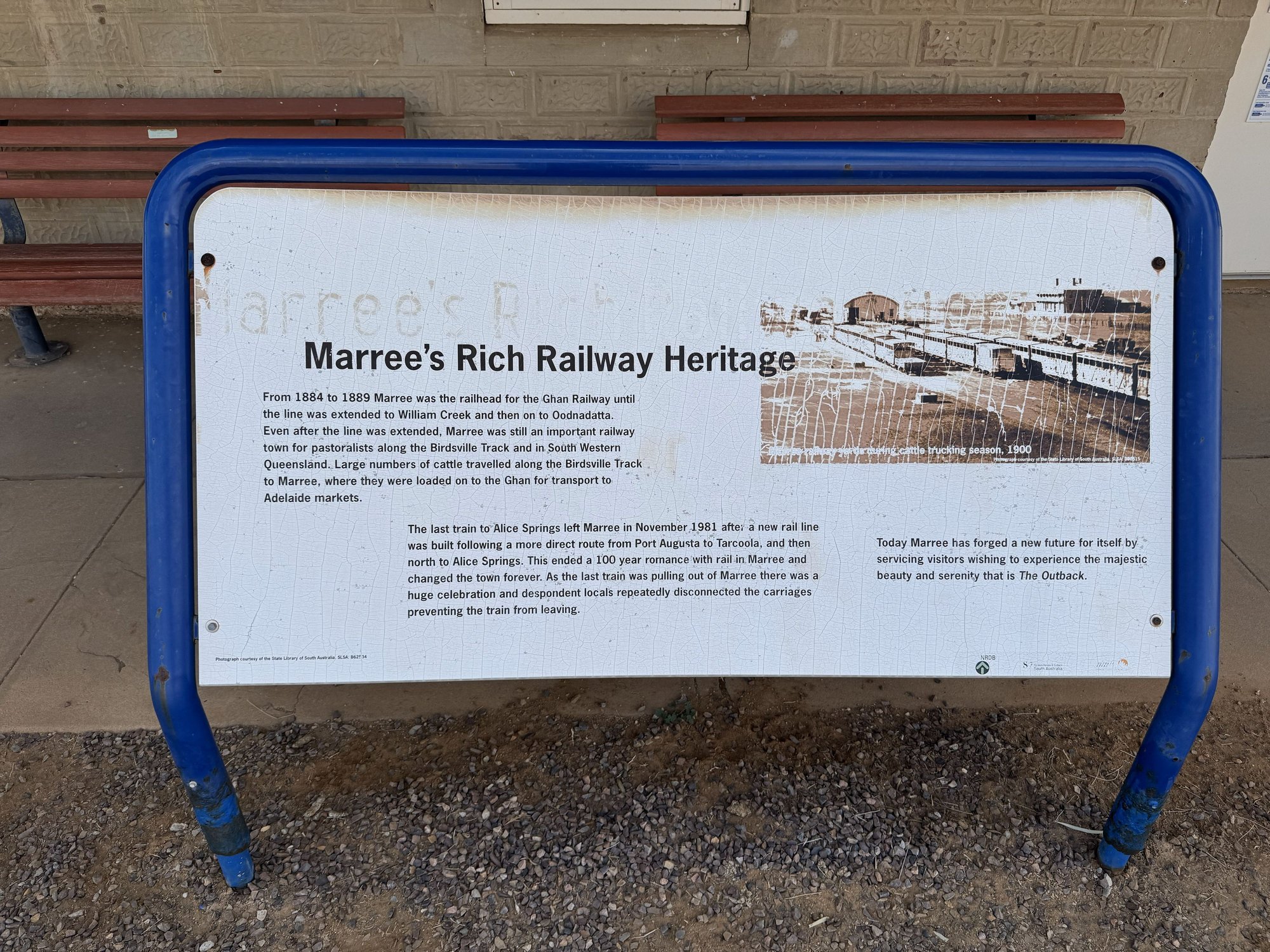
From our hotel we walked across town (maybe 300 meters) to the Marree Outback Roadhouse and Oasis Cafe that reportedly served excellent homemade meat pies and other food. On the way we took in some of Marree�s history � the old railway siding and a rusting narrow-gauge locomotive that once plied the Ghan Railway before it was rerouted further west and converted to standard gauge. Several panels described Marree�s pastoral history and its role as a railhead for shipping cattle southward to Port Augusta, animals that had been driven all the way from Queensland and the Northern Territory down the Birdsville Track. A mechanical-looking sculpture of a camel paid tribute to the role the animals played in exploring interior Australia and the men (Afghans and others from the Middle East) who drove them. (With the advent of modern transport, camels were released into the wild where they thrived and are now considered feral pests that compete with stock and wildlife for food. I was really surprised we did not see any on our travels.)
The meat pies at the Roadhouse were delicious - nothing better than a proper Aussie meat pie! And the staff were very friendly, again mostly young people from overseas, in this case Chile and France. The Lake Eyre Yacht Club was just down the road so we had a quick look inside � lots of photos, trophies, sailing paraphernalia, etc. An older guy was minding the place and expressed his frustration with the South Australian government�s decision to ban sailing on the like due to environmental concerns.
We drove to the airport, a short distance east of the town. The operator, Arid Air, was busy � we waited our turn as a couple of other sightseeing flights each carrying a dozen or so people took off ahead of us. We had booked a two-hour flight after having had the disappointment of learning the daytrip to Birdsville for lunch had been booked out.
Once in the air, we got a great aerial view of the town, just a speck amongst the endless brown terrain of Outback South Australia. Close by was the Marree Racecourse, home to the Marree Camel Cup each June and one of several camel racing venues in the Outback. The buzz of the engine made it difficult to understand the pilot�s commentary, exacerbated by his rather strong Australian accent. But I did catch a few things he pointed out along the way like the occasional bore tapping into the Great Artesian Basin, the primary source of water for much of the Outback.
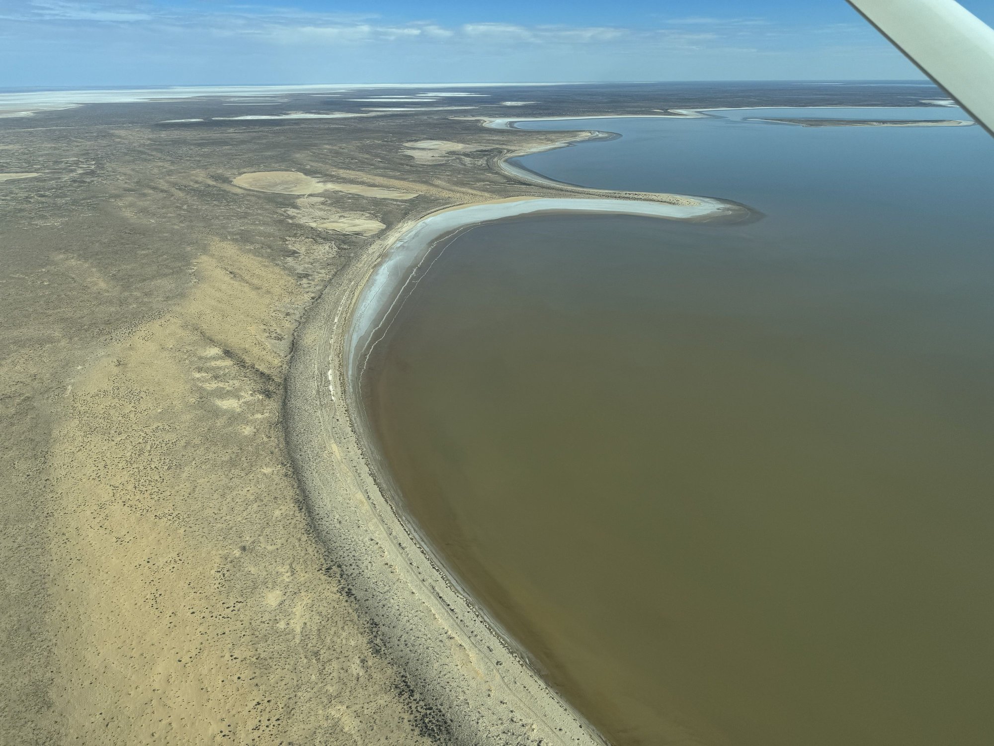
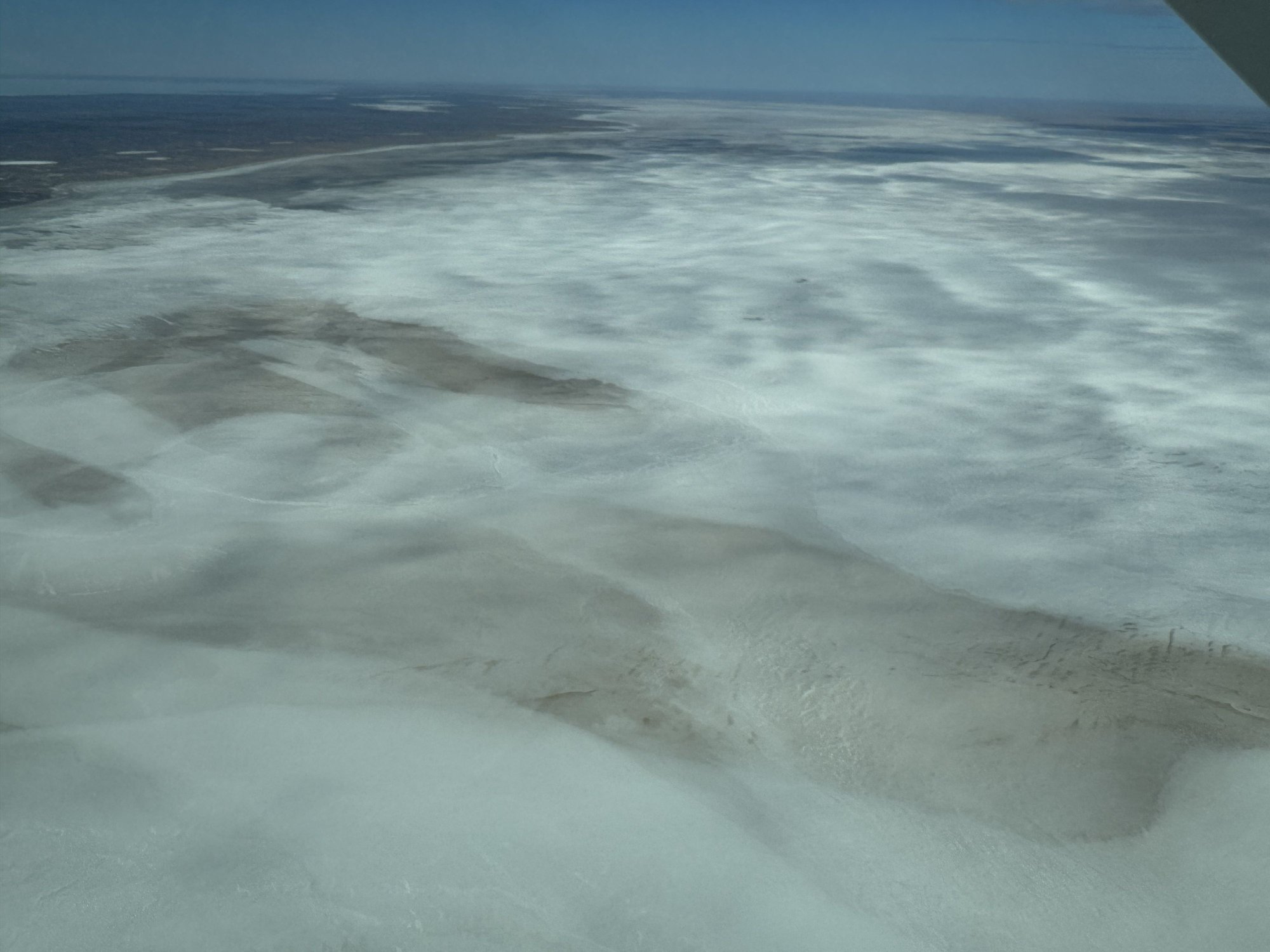
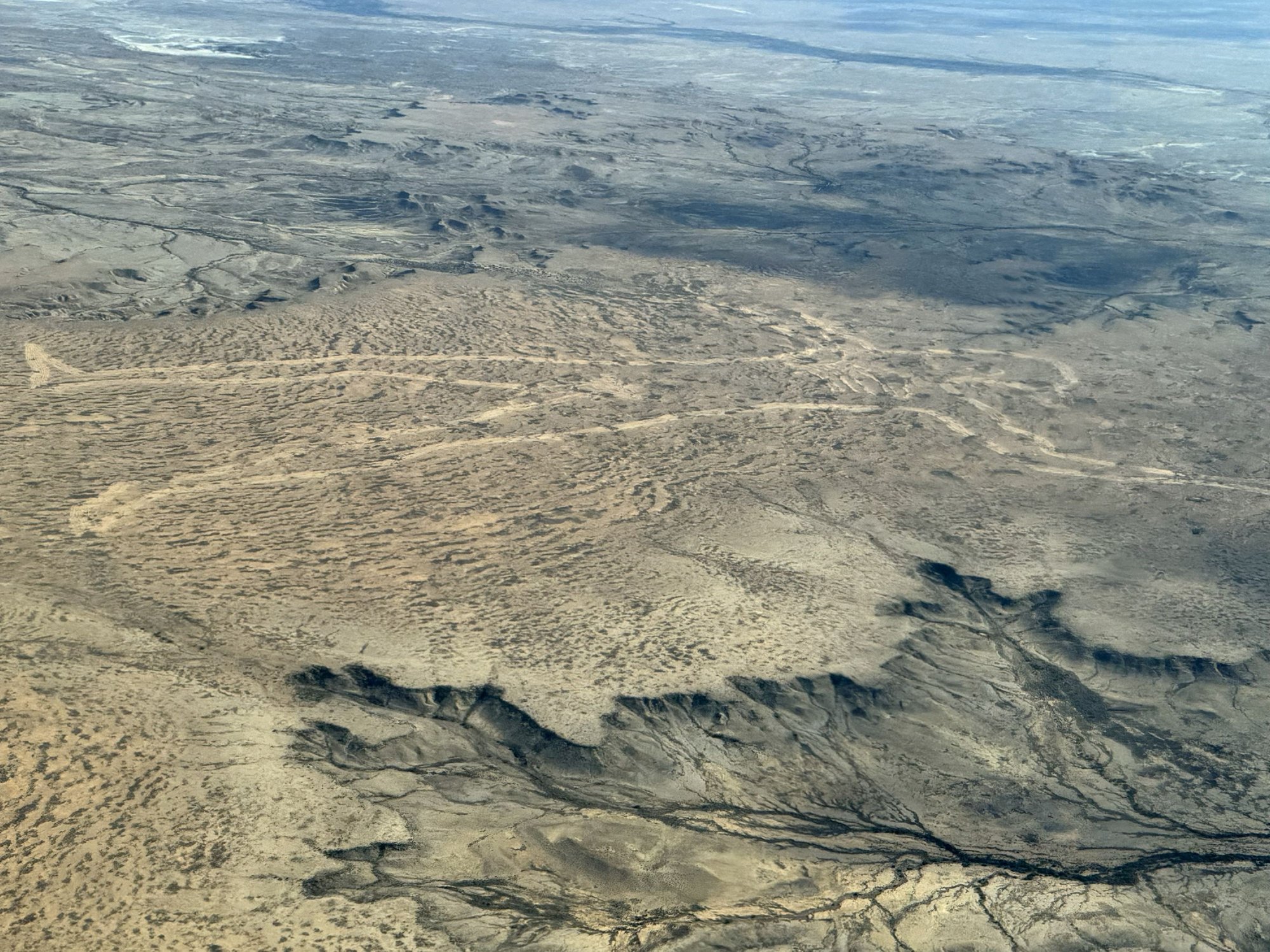
Soon we were over the greenish blue waters of the lake and could appreciate and its odd shape and its large size, roughly 145 km (90 miles) by 80 km (50 miles). Then there was a large expanse of wispy white, which I assume was the dry salt pan of South Lake Eyre, which we had seen from the ground the day before. �Marree Man� was the next highlight, one of the world�s largest geoglyphs, created by unknown �artists� sometime in the 90�s. Flying south over the Oodnadatta Track and the Old Ghan Railway, the terrain changed dramatically to the beautifully complicated sandstone escarpments of the northern Flinders Ranges, South Australia�s largest mountain range.
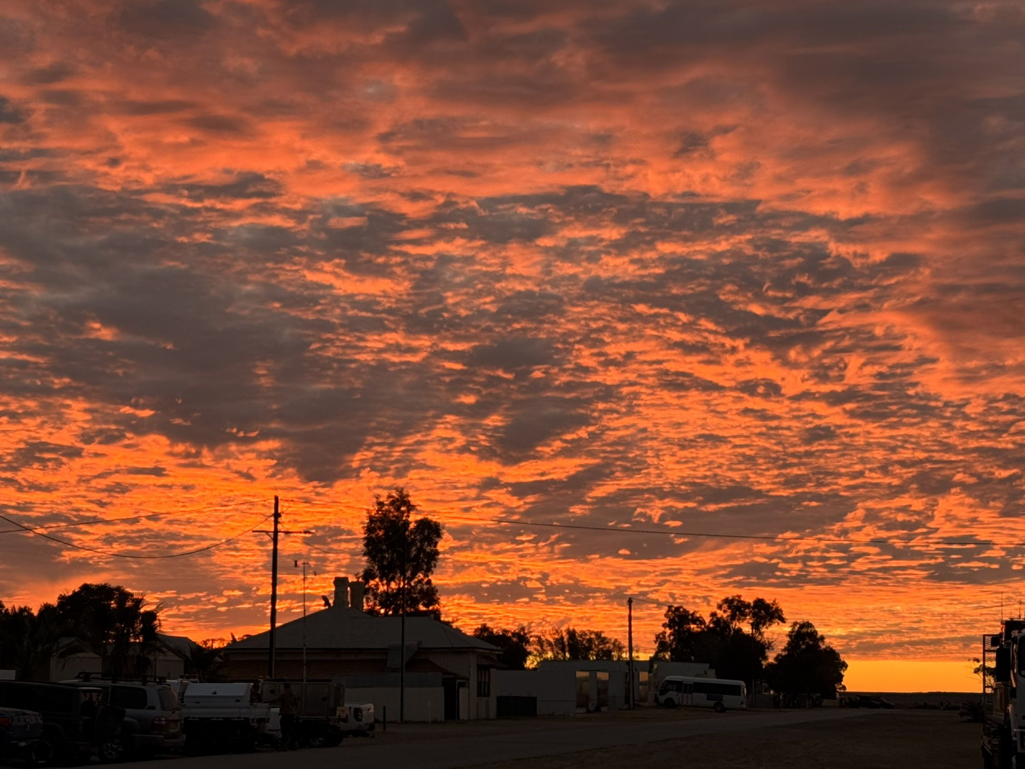
Before dinner at the hotel, we gathered with other guests outside around the fire pit while an amazing sunset developed over the road heading west. We struck up a lively conversation with a couple of funny guys, not too much younger than us, who were returning to Melbourne after a multi-day hike along the spine of the West MacDonnell Ranges in the NT. We ended up getting a table at dinner with them. The barramundi Dave and I had was very good. We might have had another drink or two, but after a big day, and after tying one on the night before, it was a relatively early bedtime.
Damn!
But we did it anyway!
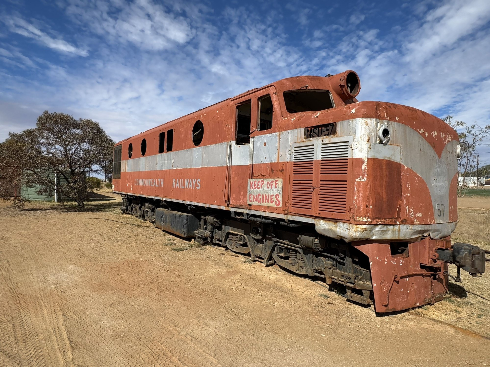
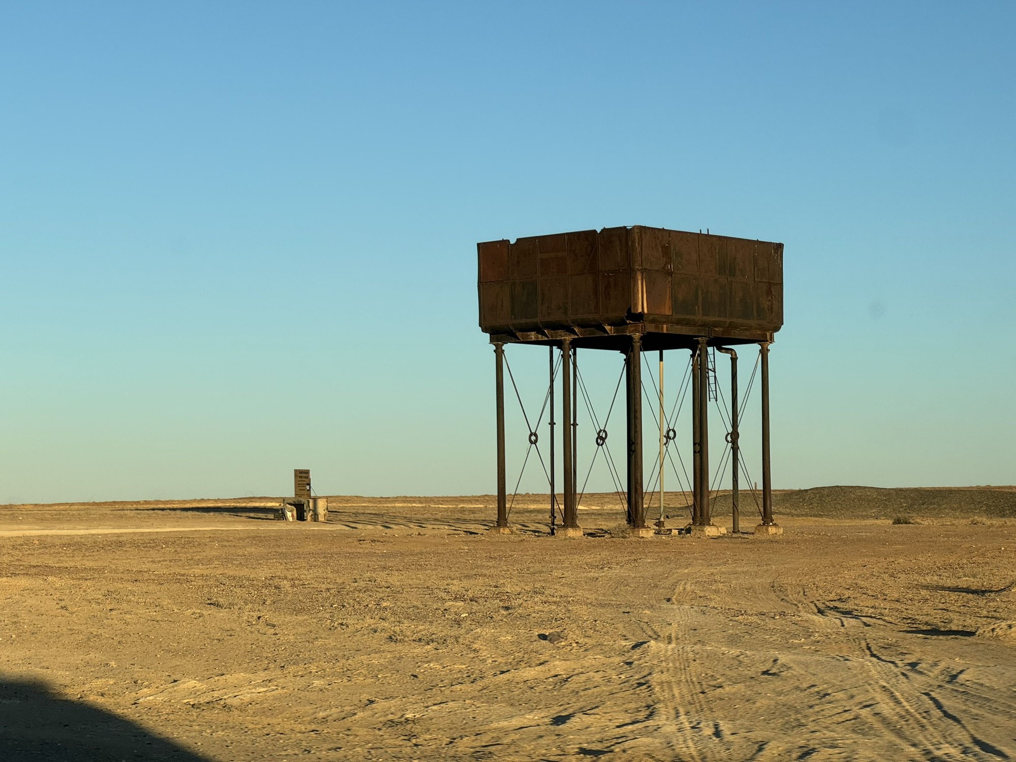
Old Ghan narrow gauge locomotive
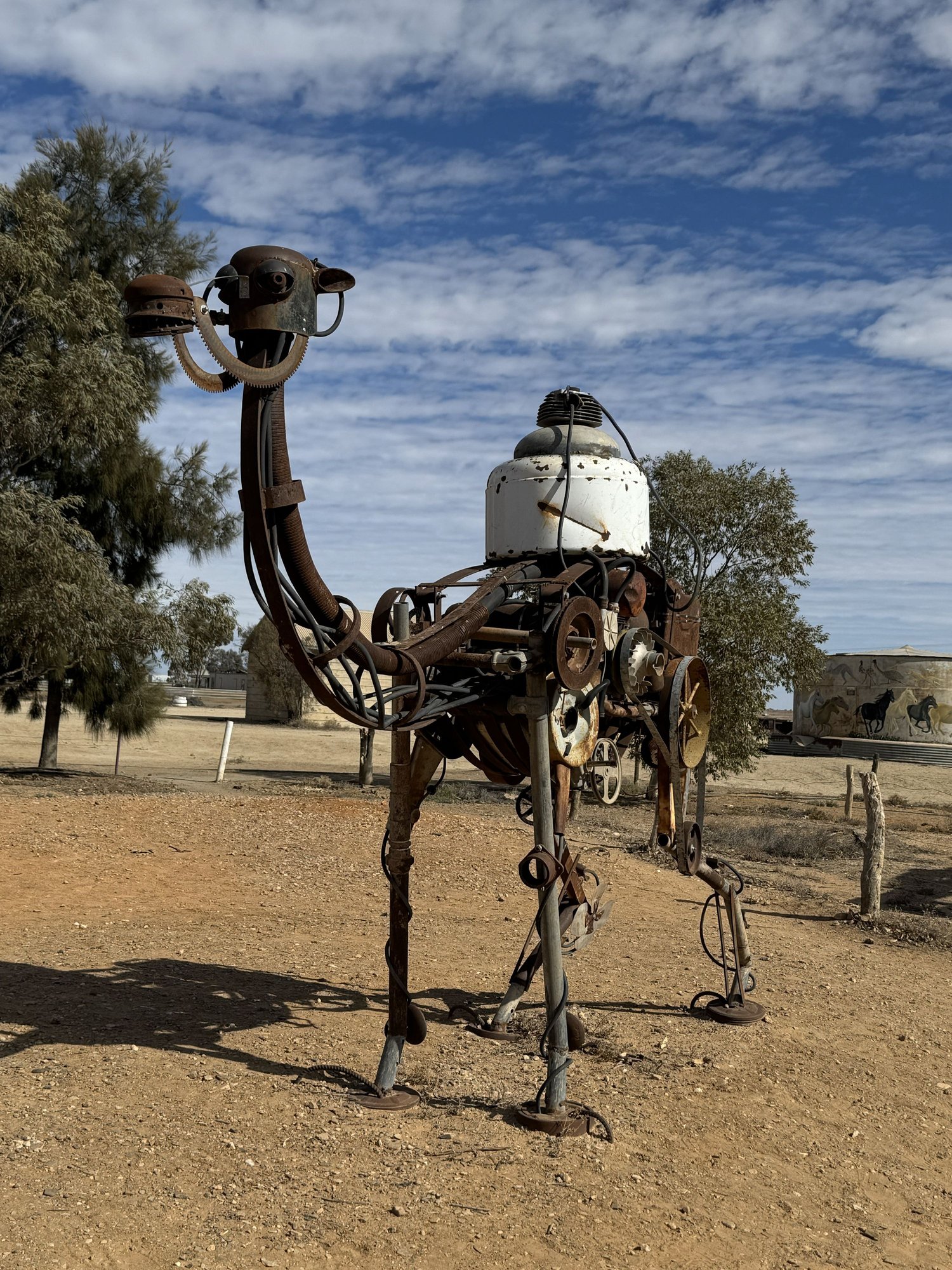
Camels played a large role in early exploration and development of Australia - they're major feral pests now.
Nothing like a fresh home-cooked Aussie pie for lunch!
About to depart for Lake Eyre
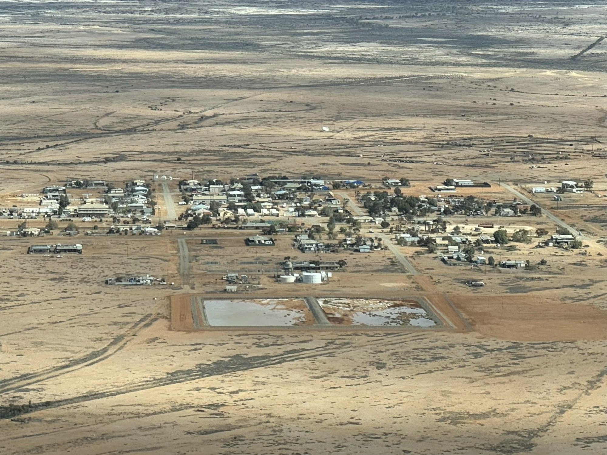
The megalopolis of Marree, South Australia from the air
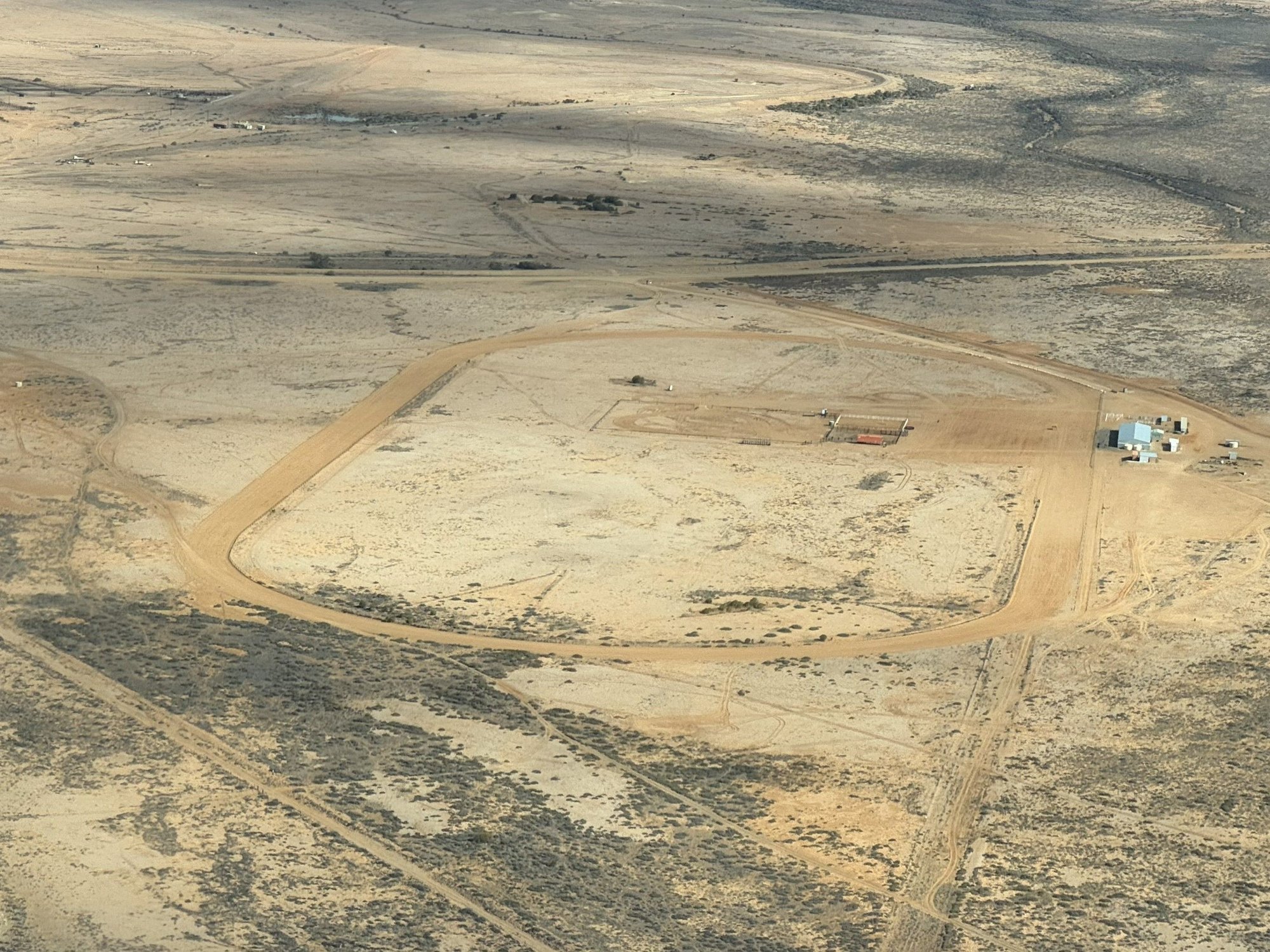
The Marree Racecource - a camel racing venue
A bore supplying water from the Great Artesian Basin
Lake Eyre - filled with water for the first time in years
South Lake Eyre - a dry salt pan, at least it was then.
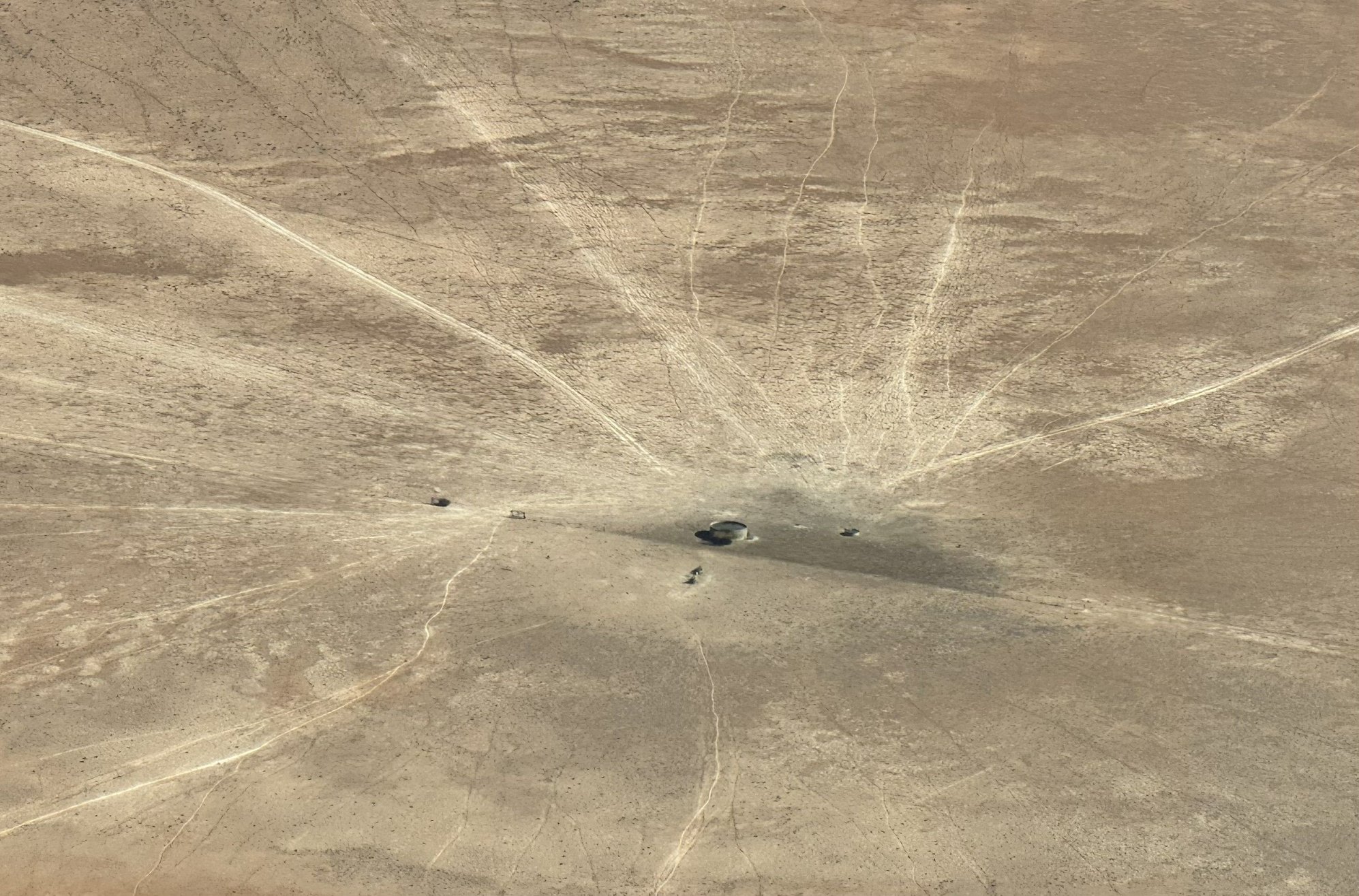
The mysterious Marree Man geoglyph - 2.7 km (1.7 miles) long

Northern Flinders Ranges near Marree
Sunset over the Marree Hotel
Intense!
Not wanting risk having to deal with a flat tire on the rough track, we stuck to around 80 k�s or about 50 mph. But it didn�t take long to figure out that at that speed, we were going to run out of time if we wanted to get lunch and make our flight. So, at the entrance to a property called Dulkaninna, about 100 km (61 miles) out of Marree, we turned around and traced our steps back to town. As it had been outbound, there was almost no traffic and� no law enforcement hidden away (which would have been impossible) to arrest us for driving on a closed road. And we could now say we�d done the Birdsville Track - well, part of it anyway.
From our hotel we walked across town (maybe 300 meters) to the Marree Outback Roadhouse and Oasis Cafe that reportedly served excellent homemade meat pies and other food. On the way we took in some of Marree�s history � the old railway siding and a rusting narrow-gauge locomotive that once plied the Ghan Railway before it was rerouted further west and converted to standard gauge. Several panels described Marree�s pastoral history and its role as a railhead for shipping cattle southward to Port Augusta, animals that had been driven all the way from Queensland and the Northern Territory down the Birdsville Track. A mechanical-looking sculpture of a camel paid tribute to the role the animals played in exploring interior Australia and the men (Afghans and others from the Middle East) who drove them. (With the advent of modern transport, camels were released into the wild where they thrived and are now considered feral pests that compete with stock and wildlife for food. I was really surprised we did not see any on our travels.)
The meat pies at the Roadhouse were delicious - nothing better than a proper Aussie meat pie! And the staff were very friendly, again mostly young people from overseas, in this case Chile and France. The Lake Eyre Yacht Club was just down the road so we had a quick look inside � lots of photos, trophies, sailing paraphernalia, etc. An older guy was minding the place and expressed his frustration with the South Australian government�s decision to ban sailing on the like due to environmental concerns.
We drove to the airport, a short distance east of the town. The operator, Arid Air, was busy � we waited our turn as a couple of other sightseeing flights each carrying a dozen or so people took off ahead of us. We had booked a two-hour flight after having had the disappointment of learning the daytrip to Birdsville for lunch had been booked out.
Once in the air, we got a great aerial view of the town, just a speck amongst the endless brown terrain of Outback South Australia. Close by was the Marree Racecourse, home to the Marree Camel Cup each June and one of several camel racing venues in the Outback. The buzz of the engine made it difficult to understand the pilot�s commentary, exacerbated by his rather strong Australian accent. But I did catch a few things he pointed out along the way like the occasional bore tapping into the Great Artesian Basin, the primary source of water for much of the Outback.
Soon we were over the greenish blue waters of the lake and could appreciate and its odd shape and its large size, roughly 145 km (90 miles) by 80 km (50 miles). Then there was a large expanse of wispy white, which I assume was the dry salt pan of South Lake Eyre, which we had seen from the ground the day before. �Marree Man� was the next highlight, one of the world�s largest geoglyphs, created by unknown �artists� sometime in the 90�s. Flying south over the Oodnadatta Track and the Old Ghan Railway, the terrain changed dramatically to the beautifully complicated sandstone escarpments of the northern Flinders Ranges, South Australia�s largest mountain range.
Before dinner at the hotel, we gathered with other guests outside around the fire pit while an amazing sunset developed over the road heading west. We struck up a lively conversation with a couple of funny guys, not too much younger than us, who were returning to Melbourne after a multi-day hike along the spine of the West MacDonnell Ranges in the NT. We ended up getting a table at dinner with them. The barramundi Dave and I had was very good. We might have had another drink or two, but after a big day, and after tying one on the night before, it was a relatively early bedtime.
Damn!
But we did it anyway!
Old Ghan narrow gauge locomotive
Camels played a large role in early exploration and development of Australia - they're major feral pests now.
Nothing like a fresh home-cooked Aussie pie for lunch!
About to depart for Lake Eyre
The megalopolis of Marree, South Australia from the air
The Marree Racecource - a camel racing venue
A bore supplying water from the Great Artesian Basin
Lake Eyre - filled with water for the first time in years
South Lake Eyre - a dry salt pan, at least it was then.
The mysterious Marree Man geoglyph - 2.7 km (1.7 miles) long
Northern Flinders Ranges near Marree
Sunset over the Marree Hotel
Intense!
Last edited by RalphR; Dec 21st, 2025 at 12:40 PM. Reason: add more photos
Apr 25th, 2026 | 01:43 PM
#57
Joined: Mar 2023
Posts: 4
Likes: 0
Marree to Arkaroola Wildlife Sanctuary (South Australia)
(Finally settled at home for a while and determined to finish this trip report before the trip anniversary happens in July!)
Tuesday July 15, 2025: Up to this morning, we had awoken during each of the last couple of weeks to a brilliant blue sky. But this day started out as it ended - dull and grey with occasional light rain. Marree is not only the terminus for the unsealed Oodnadatta and Birdsville Tracks but was also (for us) the beginning of the paved Outback Hwy, which we took, heading south towards Adelaide. Not far out of Marree we started seeing more wildlife about, particularly emus and the odd �roo.
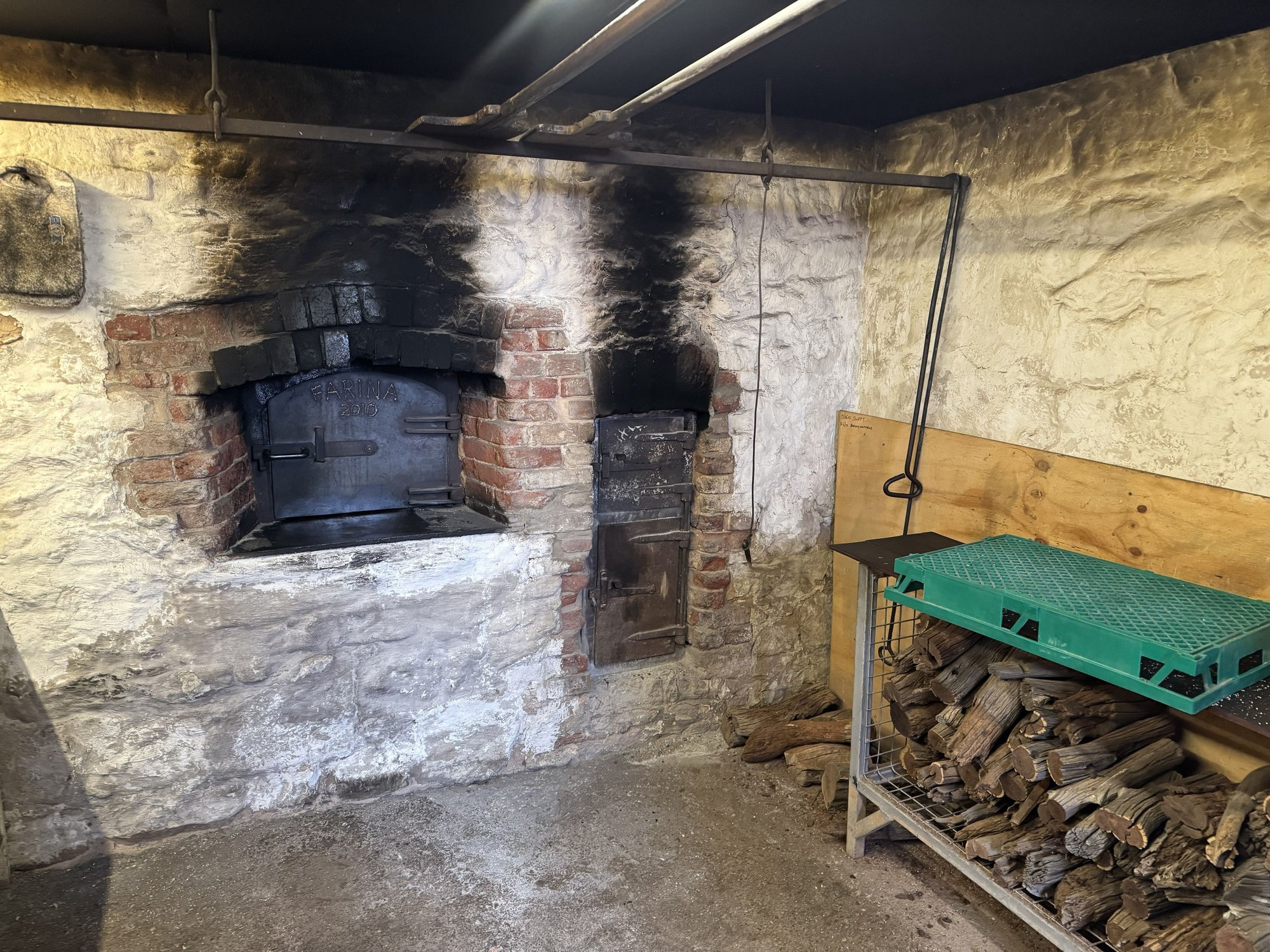
About 50 km (30 miles) down the road, we stopped in Farina, another town on the old Ghan Railway that suffered the rerouting of the tracks. Farina was abandoned altogether, and while there are no permanent residences and the buildings are stone ruins, a volunteer restoration group now operates the original underground Scotch oven supplying a modern bakery selling delicious meat pies, pastries, tea and coffee during the cooler tourist months. We walked through the ruins taking in some of the panels on Farina�s history and former inhabitants. Of course, we couldn�t resist having pastry and taking away meat pies for lunch. Despite its remoteness, the bakery business was booming that morning � we even ran into our new friends we had met at the Marree pub the previous evening.
Continuing south, it looked as if the weather was improving � large patches of blue, but once we left the paved road near Leigh Creek toward Arkaroola, our destination to the east, the weather soured once again. Not far out of Leigh Creek we were passed by a couple of dirt bikes, which stayed annoyingly close to us for some distance throwing up dust in our faces. We didn�t realize it at the time, but this was a sign more motorcycle-related fun to come. Further on, we somehow lost the motorcycles, but the rain started again and now the red dust was sticking to our vehicle - what was once white was now red. I shouldn�t complain about the weather that day since we had been so lucky up that time, but we were then in what looked to be a very scenic area as the road wound its way through the Gammon Ranges National Park. Before the final stretch, we enjoyed our Farina meat pies at high viewpoint on the west of a park overlooking a flat plain to the east.
Arkaroola is a well-known wildlife sanctuary in South Australia�s northern Flinders Ranges. We arrived in the late afternoon to soon find out that we were practically the only people arriving on four wheels � the place had been virtually taken over by an organized dirt bike association touring South Australia�s outback. We booked into the motel-style accommodation then headed to the bar feeling a bit out of place amongst cliquey groups of dirt bike enthusiasts. Even though there was a nice fire to sit around, it wasn�t the atmosphere of the Marree pub, where everyone was on their own looking to strike up a conversation. Then the worst part � they shut the bar at 5:00 PM and sent everyone around the back to the outside bar for a BBQ dinner. Apparently, no one on the staff stopped to consider that it could be quite cold (which it was) and that it could be wet (which it was). We asked if we could be let back inside to sit around the fire but were told we�d have to make do with the outdoor firepit. So, we grabbed some BBQ and a beer and sat on a picnic table under the cover of an open pavilion with tin roof. If it was 25 C and dry, that would have been just fine. But it wasn�t.
Things looked much better as we stepped out to a beautiful cloudless sky after a good night�s sleep. The continental breakfast included in our package was limited, although a cooked breakfast was available at extra cost. The resort offered several options for things to do including minibus tours and hiking the trails that wind up and around the ranges surrounding the property. We chose to hike the Acacia Ridge Trail that began just outside. This turned out to be a wonderful hike with fantastic views extending east to the salt flats around Lake Frome. We encountered lots of emus along the way as well as some interesting vegetation such as grass trees, weird plants that could well have been inspired by Dr. Suess. We had seen road signs warning drivers of quolls and were expecting to see a few, but that was not to be the case. Since the Acacia Ridge Trail was not a loop, once we reached the road, we began to make our way back to the lodge on the tarmac. Then, to our delight, one of the Arkaroola tour busses stopped and offered us a ride, which we gladly accepted. The driver was very friendly � we were feeling a lot better about Arkaroola by this time.
After lunch we explored the resort taking a walk up to the small observatory perched on a low hill behind the property and visiting
the excellent mineral collection housed in a separate building on site. Late in the afternoon we set out to climb Griselda Hill, a prominent conical peak overlooking the resort. At first the track was graded and easy to follow, but further up we entered a boulder field with no markers showing the way to the top. As we probed routes to scale the final section we came upon a mob of rare, yellow footed rock wallabies who were easily able to keep their distance from us using their far superior rock hopping skills. Nonetheless I was able to get a few good pictures of the adorable creatures.
Supper that night was much more enjoyable � an indoor one of schnitzel, gravy and fries.
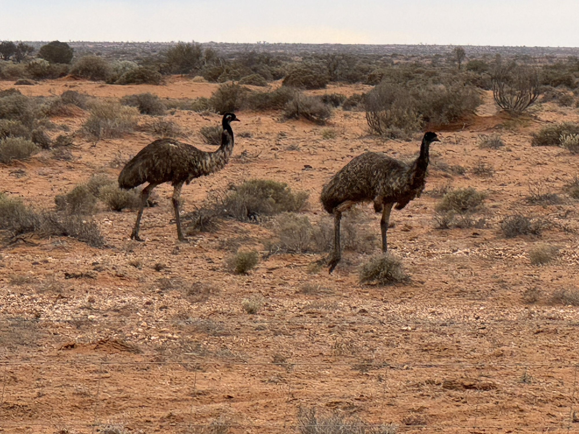
The first of many emus we saw that day...
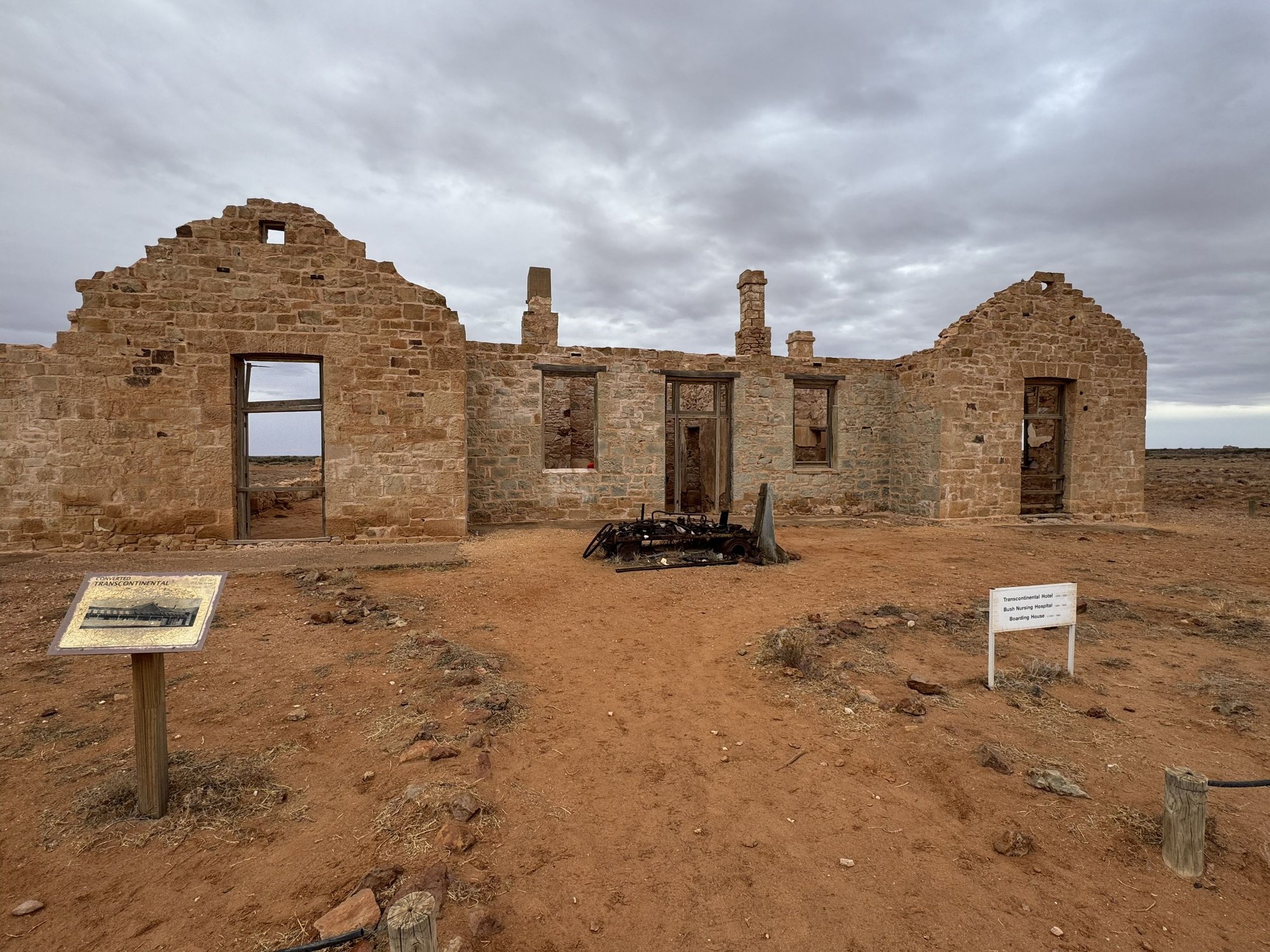
The ruins of the Transcontinental Hotel, Farina
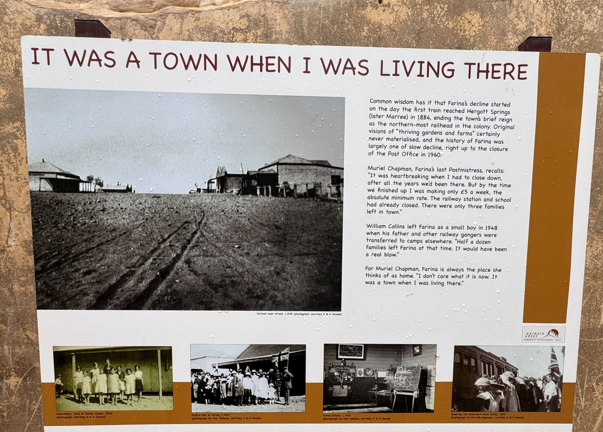
The sad, slow decline to become a ghost town
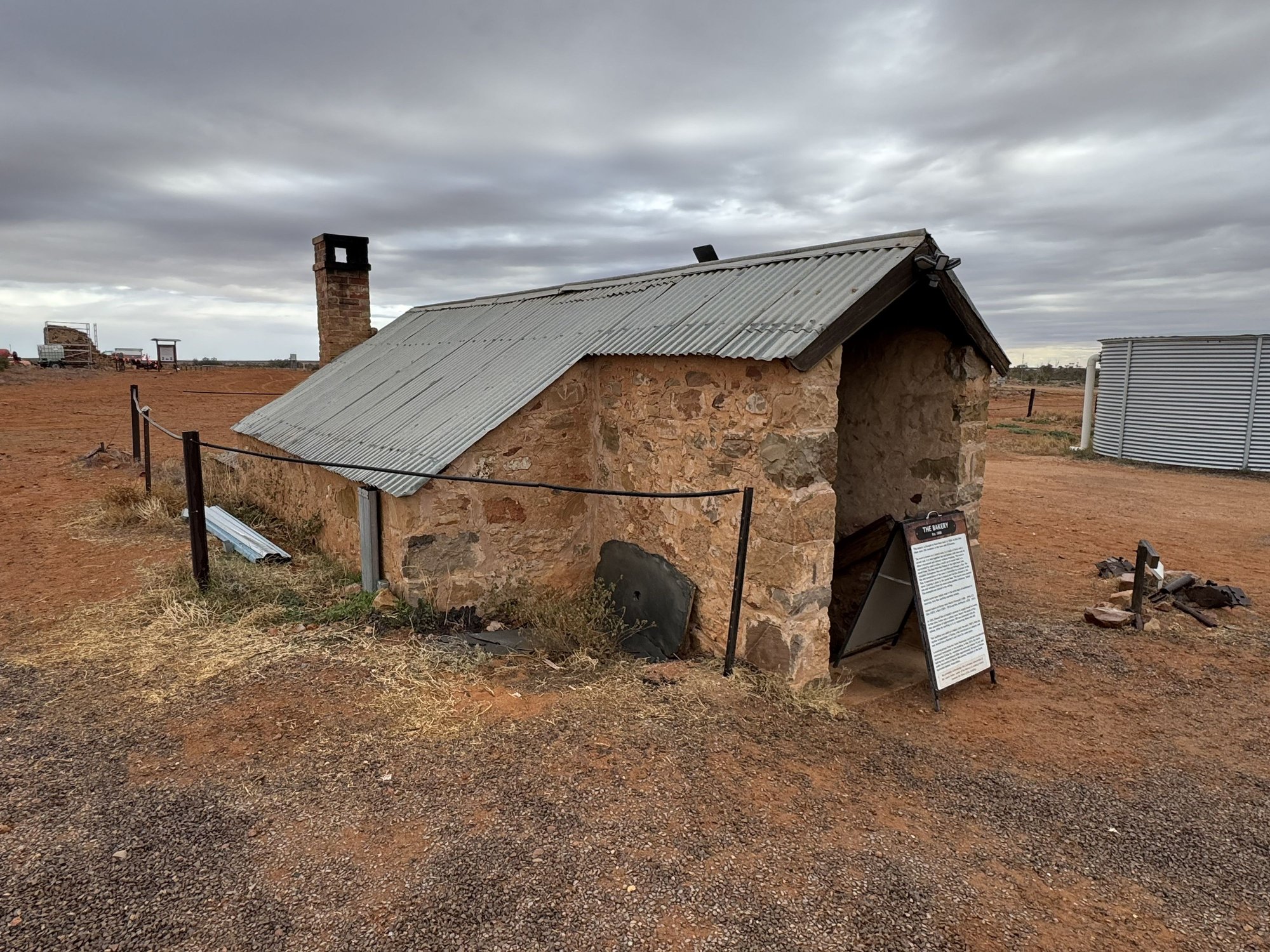
The Farina Scotch oven - now back in use!

Our new friends from Victoria Mike and Paul (left) at the modern, bustling Farina Bakery

Crappy weather as we traversed the scenic Gammon Ranges Nat'l Park

Unfortunately they were avoiding us! No sightings.
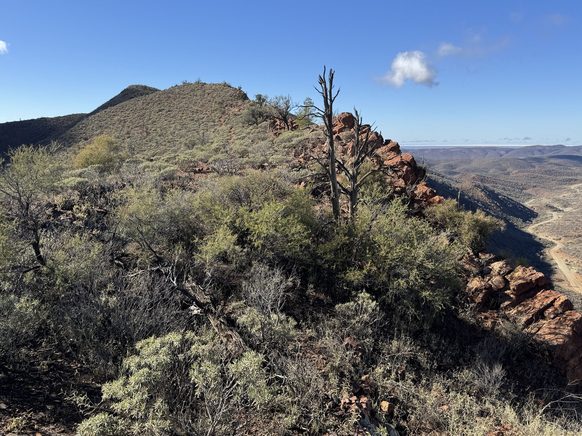
The Acacia Ridge, a great hike in the Arkaroola Wildlife Sanctuary. The road into the lodge is on the far right.
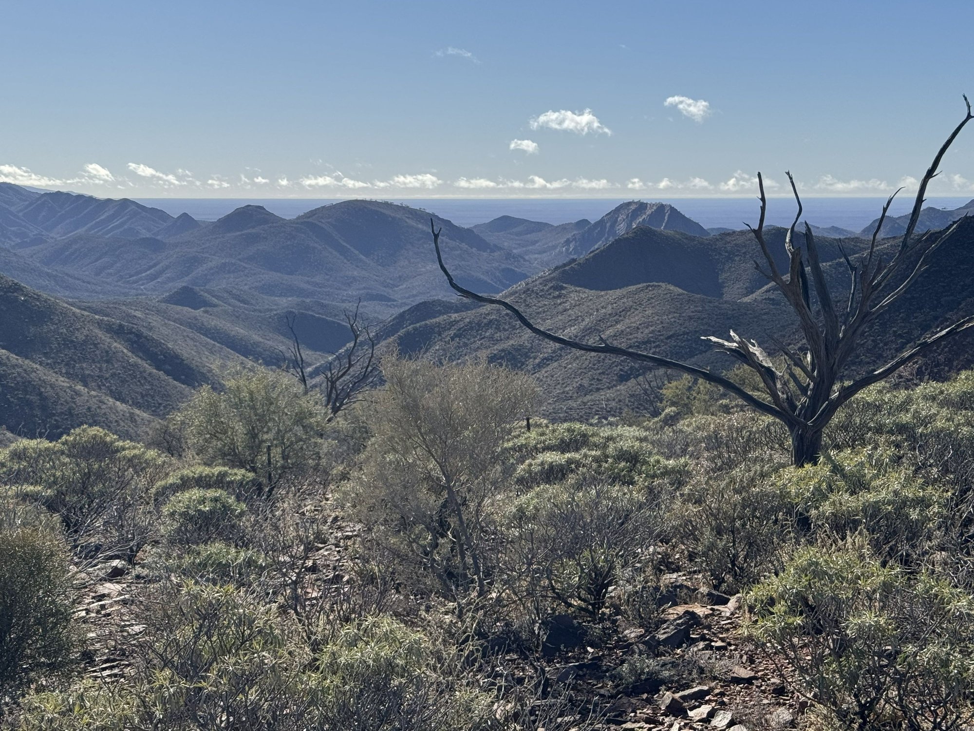
Great views from the ridge - Lake Frome (a dry salt lake) is a thin white line on the horizon
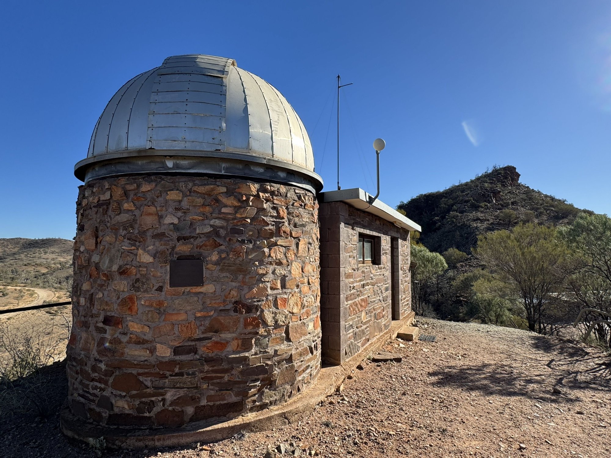
Arkaroola Observatory. A great place for stargazing, with clear dry skies and practically no light pollution.
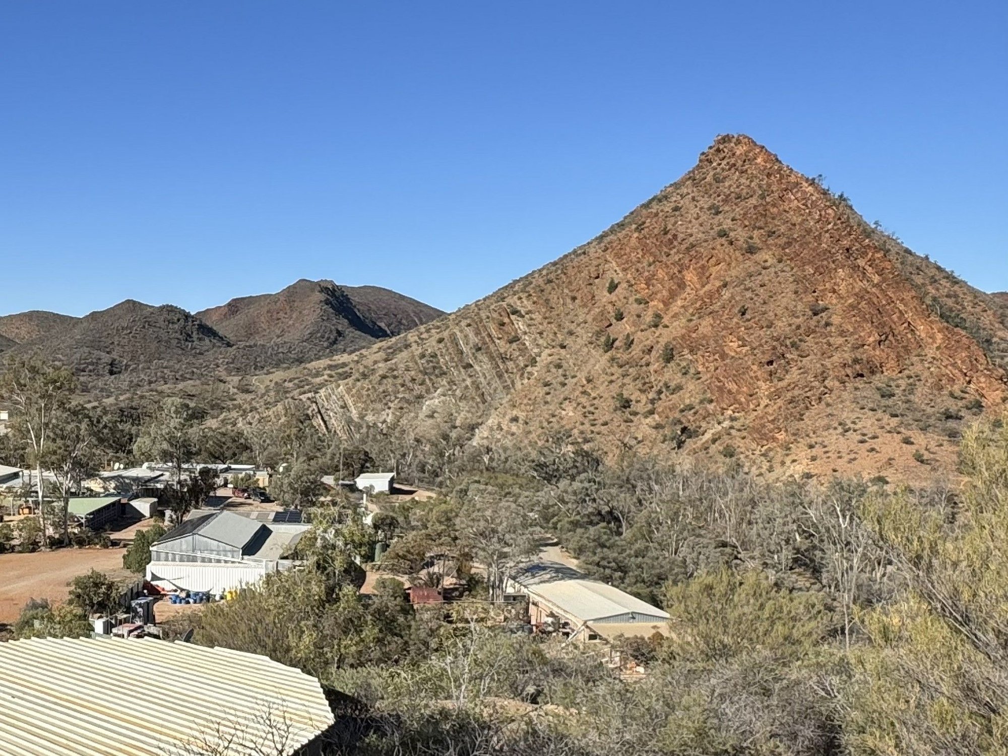
Griselda Hill from the observatory, the resort below.
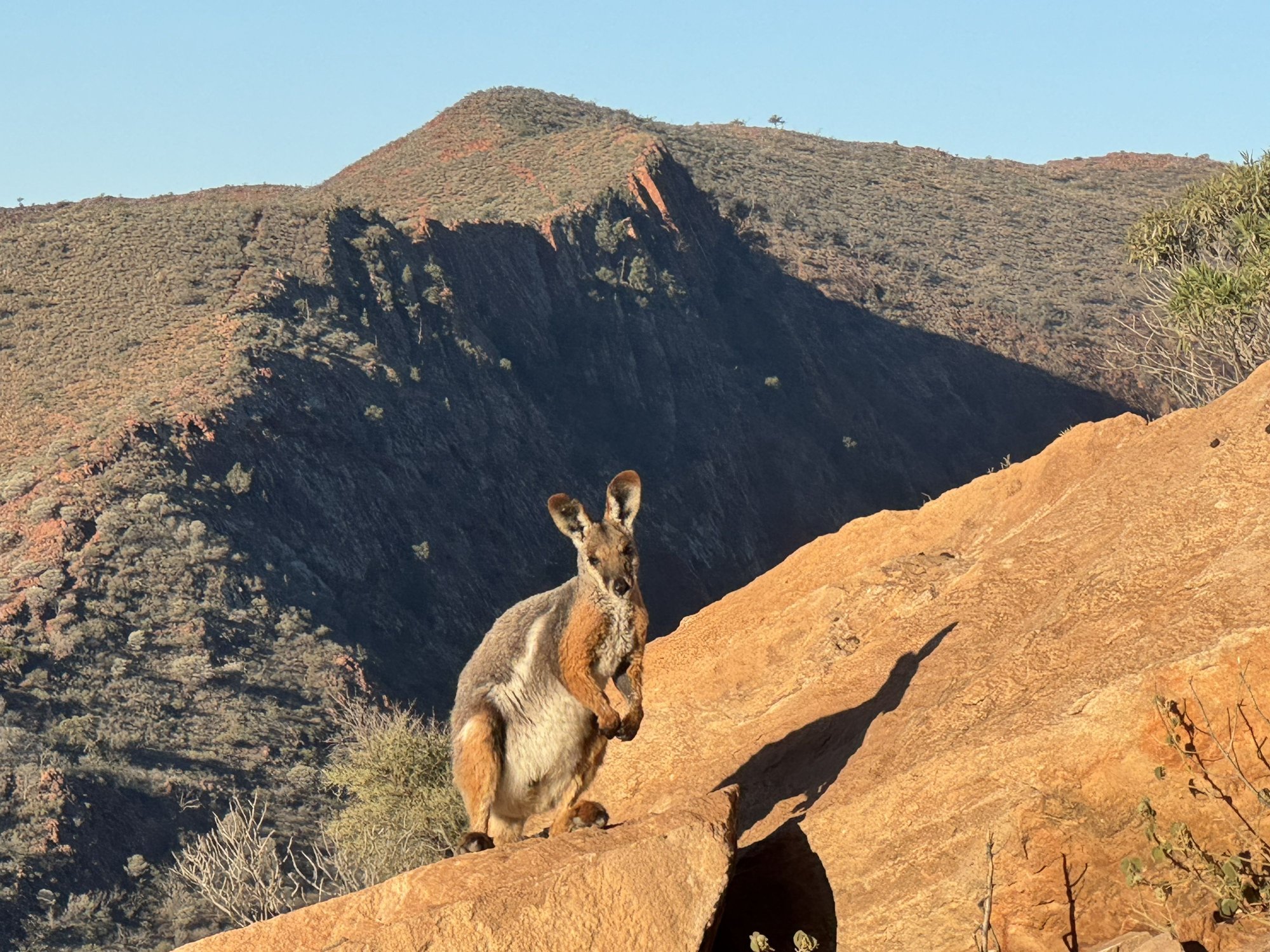
Yellow-footed rock wallaby atop Griselda Hill. There was a whole mob of these guys up there.
Tuesday July 15, 2025: Up to this morning, we had awoken during each of the last couple of weeks to a brilliant blue sky. But this day started out as it ended - dull and grey with occasional light rain. Marree is not only the terminus for the unsealed Oodnadatta and Birdsville Tracks but was also (for us) the beginning of the paved Outback Hwy, which we took, heading south towards Adelaide. Not far out of Marree we started seeing more wildlife about, particularly emus and the odd �roo.
About 50 km (30 miles) down the road, we stopped in Farina, another town on the old Ghan Railway that suffered the rerouting of the tracks. Farina was abandoned altogether, and while there are no permanent residences and the buildings are stone ruins, a volunteer restoration group now operates the original underground Scotch oven supplying a modern bakery selling delicious meat pies, pastries, tea and coffee during the cooler tourist months. We walked through the ruins taking in some of the panels on Farina�s history and former inhabitants. Of course, we couldn�t resist having pastry and taking away meat pies for lunch. Despite its remoteness, the bakery business was booming that morning � we even ran into our new friends we had met at the Marree pub the previous evening.
Continuing south, it looked as if the weather was improving � large patches of blue, but once we left the paved road near Leigh Creek toward Arkaroola, our destination to the east, the weather soured once again. Not far out of Leigh Creek we were passed by a couple of dirt bikes, which stayed annoyingly close to us for some distance throwing up dust in our faces. We didn�t realize it at the time, but this was a sign more motorcycle-related fun to come. Further on, we somehow lost the motorcycles, but the rain started again and now the red dust was sticking to our vehicle - what was once white was now red. I shouldn�t complain about the weather that day since we had been so lucky up that time, but we were then in what looked to be a very scenic area as the road wound its way through the Gammon Ranges National Park. Before the final stretch, we enjoyed our Farina meat pies at high viewpoint on the west of a park overlooking a flat plain to the east.
Arkaroola is a well-known wildlife sanctuary in South Australia�s northern Flinders Ranges. We arrived in the late afternoon to soon find out that we were practically the only people arriving on four wheels � the place had been virtually taken over by an organized dirt bike association touring South Australia�s outback. We booked into the motel-style accommodation then headed to the bar feeling a bit out of place amongst cliquey groups of dirt bike enthusiasts. Even though there was a nice fire to sit around, it wasn�t the atmosphere of the Marree pub, where everyone was on their own looking to strike up a conversation. Then the worst part � they shut the bar at 5:00 PM and sent everyone around the back to the outside bar for a BBQ dinner. Apparently, no one on the staff stopped to consider that it could be quite cold (which it was) and that it could be wet (which it was). We asked if we could be let back inside to sit around the fire but were told we�d have to make do with the outdoor firepit. So, we grabbed some BBQ and a beer and sat on a picnic table under the cover of an open pavilion with tin roof. If it was 25 C and dry, that would have been just fine. But it wasn�t.
Things looked much better as we stepped out to a beautiful cloudless sky after a good night�s sleep. The continental breakfast included in our package was limited, although a cooked breakfast was available at extra cost. The resort offered several options for things to do including minibus tours and hiking the trails that wind up and around the ranges surrounding the property. We chose to hike the Acacia Ridge Trail that began just outside. This turned out to be a wonderful hike with fantastic views extending east to the salt flats around Lake Frome. We encountered lots of emus along the way as well as some interesting vegetation such as grass trees, weird plants that could well have been inspired by Dr. Suess. We had seen road signs warning drivers of quolls and were expecting to see a few, but that was not to be the case. Since the Acacia Ridge Trail was not a loop, once we reached the road, we began to make our way back to the lodge on the tarmac. Then, to our delight, one of the Arkaroola tour busses stopped and offered us a ride, which we gladly accepted. The driver was very friendly � we were feeling a lot better about Arkaroola by this time.
After lunch we explored the resort taking a walk up to the small observatory perched on a low hill behind the property and visiting
the excellent mineral collection housed in a separate building on site. Late in the afternoon we set out to climb Griselda Hill, a prominent conical peak overlooking the resort. At first the track was graded and easy to follow, but further up we entered a boulder field with no markers showing the way to the top. As we probed routes to scale the final section we came upon a mob of rare, yellow footed rock wallabies who were easily able to keep their distance from us using their far superior rock hopping skills. Nonetheless I was able to get a few good pictures of the adorable creatures.
Supper that night was much more enjoyable � an indoor one of schnitzel, gravy and fries.
The first of many emus we saw that day...
The ruins of the Transcontinental Hotel, Farina
The sad, slow decline to become a ghost town
The Farina Scotch oven - now back in use!
Our new friends from Victoria Mike and Paul (left) at the modern, bustling Farina Bakery
Crappy weather as we traversed the scenic Gammon Ranges Nat'l Park
Unfortunately they were avoiding us! No sightings.
The Acacia Ridge, a great hike in the Arkaroola Wildlife Sanctuary. The road into the lodge is on the far right.
Great views from the ridge - Lake Frome (a dry salt lake) is a thin white line on the horizon
Arkaroola Observatory. A great place for stargazing, with clear dry skies and practically no light pollution.
Griselda Hill from the observatory, the resort below.
Yellow-footed rock wallaby atop Griselda Hill. There was a whole mob of these guys up there.
Apr 26th, 2026 | 06:34 AM
#59
Joined: Jan 2008
Posts: 9,768
Likes: 0
Ralph, your TR is such a rarity, as we get far too few Outback reports here. Just like Kay, I agree about that wallaby shot--very nice indeed.
I was just informed by the Fodors Executive Committee that it has been decided: you are now required to compose a song titled 'Rock Wallaby'.
That tune will need to conform to the influence of the B-52's famed 'Rock Lobster' number.
I am done. the wallabeez
I was just informed by the Fodors Executive Committee that it has been decided: you are now required to compose a song titled 'Rock Wallaby'.
That tune will need to conform to the influence of the B-52's famed 'Rock Lobster' number.
I am done. the wallabeez


