

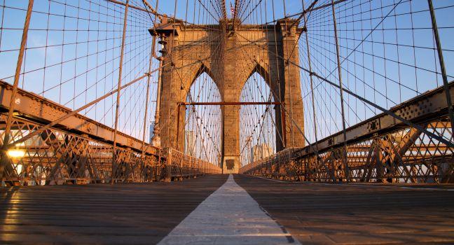
Brooklyn Bridge (Entrance)
Get FREE email communications from Fodor's Travel, covering must-see travel destinations, expert trip planning advice, and travel inspiration to fuel your passion.

We've compiled the best of the best in USA - browse our top choices for the top things to see or do during your stay.
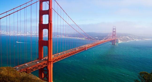
Crossing the Golden Gate Bridge under your own power is exhilarating—a little scary, and definitely chilly. From the bridge's eastern-side walkway, the only side pedestrians are allowed on, you can take in the San Francisco skyline and the bay islands; look west for the wild hills of the Marin Headlands, the curving coast south to Lands End, and the Pacific Ocean. On sunny days, sailboats dot the water and brave windsurfers test the often-treacherous tides beneath the bridge. A vista point on the Marin County side provides a spectacular city panorama.
A structural engineer, dreamer, and poet named Joseph Strauss worked tirelessly for 20 years to make the bridge a reality, first promoting the idea of it and then overseeing design and construction. Though the final structure bore little resemblance to his original plan, Strauss guarded his legacy jealously, refusing to recognize the seminal contributions of engineer Charles Ellis. In 2007, the Golden Gate Bridge district finally recognized Ellis's role, though Strauss, who died less than a year after the bridge's opening day in 1937, would doubtless be pleased with the inscription on his statue, which stands sentry in the southern parking lot: "The Man Who Built the Bridge."
At the outdoor exhibits near the bridge's Welcome Center, you can learn about the features that make it art deco and read about the personalities behind its design and construction. For some pre– or post–bridge walk fuel, there is an Equator Coffees café in the historic Round House at the visitor's plaza. City Guides ( sfcityguides.org) offers free walking tours of the bridge every Thursday and Sunday at 11 am.
Austin is home to the largest urban bat population in the world, with as many as 1.5 million Mexican free-tailed bats taking up residence in the capital city every year. Every night starting in late March and continuing through fall, locals and visitors congregate all along (and underneath) Congress Avenue to watch the bats take flight from under the Congress Avenue Bridge for their nightly feeding ritual. On hot nights (with no rain), right around sundown, don't miss the incredible opportunity (for photographers, families, and nature lovers alike) to witness this natural phenomenon set against the backdrop of the downtown skyline.
Most visitors cross the Brooklyn Bridge from Manhattan, but you'll get better views traversing the span from the Brooklyn side. It's a surprisingly long walk (more than a mile) that normally takes about 40 minutes, but the exhilarating views are worth the exertion. No need to look out for cyclists; a separated bike lane on the vehicle road has made the pedestrian walkway much more pleasant. The bridge is most magical and quiet in the early morning, but if you don't mind the crowds, it's worth making the trip at sunset in summer, when the lights of Manhattan come to life. There are two pedestrian access points for the bridge on the Brooklyn side: at the intersection of Tillary Street and Adams Street, and another in DUMBO from a staircase at the underpass where Cadman Plaza East intersects Prospect Street.
Known as the quintessential spot to get that perfect skyline shot of downtown Atlanta, the Jackson Street Bridge is iconic not just because of the view, but because of its appearance in the show The Walking Dead. If you time it just right, you'll get a photo of the sun setting over Downtown as a bonus.
In 2017, heavy winter rains caused an old concrete bridge built in 1968 to crack and slip downhill at Pfeiffer Canyon, in the heart of Big Sur. Engineers deemed the old bridge irreparable, and auto and pedestrian access to Highway 1 south of the bridge was cut off indefinitely. CalTrans quickly made plans to construct a new, $24-million bridge to span the deep canyon. Normally, such a massive project would take at least seven years, but CalTrans accelerated the project and completed it in less than a year. The new bridge—a 21st-century engineering marvel—stretches 310 feet across the ravine without the need for column support. It's made of 15 steel girders, each weighing 62 tons and connected by steel plates holding 14,000 bolts.
It's a dizzying experience to see the Rio Grande 650 feet underfoot, where it flows at the bottom of an immense, steep rock canyon. In summer the reddish rocks dotted with green scrub contrast brilliantly with the blue sky, where you might see a hawk lazily floating in circles. The bridge is one of the highest suspension bridges in the country. Hold on to your camera and eyeglasses when looking down. Many days just after daybreak, hot-air balloons fly above and even inside the gorge. There's a campground with picnic shelters and basic restrooms on the west side of the bridge.
This is one of the most photographed images in the Keys. Actually measuring slightly less than 7 miles, it connects the Middle and Lower Keys and is believed to be the world's longest segmental bridge, with 39 expansion joints separating its various concrete sections. Each April, runners gather in Marathon for the annual Seven Mile Bridge Run.
The expanse running parallel to the Seven Mile Bridge is what remains of the Old Seven Mile Bridge, an engineering and architectural marvel in its day that's now on the National Register of Historic Places. Once proclaimed the Eighth Wonder of the World, it rested on a record 546 concrete piers. A $44 million renovation, begun in 2017, is part of a 30-year, $77-million restoration and maintenance agreement between the Keys' Monroe County, Marathon municipal officials, and the Florida Department of Transportation. No cars are allowed on the old bridge, but the oft-photographed, 2.2-mile span is open to pedestrians and serves as the gateway to historic Pigeon Key, an islet nestled beneath the “Old Seven” that was once home to about 400 workers constructing the railroad.

The graceful arc of Bixby Creek Bridge is a photographer's dream. Built in 1932, the bridge spans a deep canyon, more than 100 feet wide at the bottom. From the north-side parking area you can admire the view or walk the 550-foot structure. The parking area is very small. Follow all signs regarding how (e.g., single-file, parallel to the bluff) and where to park. If there are no spots, cross the bridge to one of the pullouts to the south.
When the bridge opened in 1926, its 1,750-foot main span made it the longest suspension bridge in the world. Paul Cret, architect of the Rodin Museum, was the designer. The bridge, which crosses the Delaware River, is mainly used by cars and the PATCO commuter train, which has several stops in Center City and South Jersey. The bridge is most impressive when it's lit at night. Start the 1¾-mile walk (one way) from either the Philadelphia side, two blocks north of the U.S. Mint, or the Camden, New Jersey, side, where there are metered parking lots. Enjoy stunning city views along the way, but know it's best to walk across on mornings or cooler days, as there's no shade.
Early Kent residents Jacob and Isaac Bull first built a bridge on this site in 1760, where it was later crossed—as local legend has it—by George Washington. The current covered bridge was built in 1842, and is one of just a handful of covered bridges left in the state still open to traffic. It has been reinforced over the years, and was added to the National Register of Historic Places in 1972. If you feel like a hike, there is an easy trail that leads to waterfalls and a small gorge.
The official gateway into Balboa Park soars 125 feet above a canyon floor. Pedestrian-friendly, the nearly 1,500-foot bridge provides inspiring views of the California Tower and El Prado beyond.
This is a great spot for photographing a classic image of the park.
This 460-foot bridge, 1½ miles south of the Saint-Gaudens National Historic Site, connects New Hampshire to Vermont across the Connecticut River. Erected in 1866, it is the second-longest covered bridge in the United States. The notice on the bridge reads, "Walk your horses or pay two dollar fine."
Chicago is a city of bridges—and this one, completed in 1920, is among the most graceful. The structure's four pylons are decorated with impressive sculptures representing major Chicago events: its exploration by Marquette and Joliet, its settlement by trader Jean Baptiste Point du Sable, the Fort Dearborn Massacre of 1812, and the rebuilding of the city after the Great Chicago Fire of 1871. The site of the fort, at the south end of the bridge, is marked by a commemorative plaque. As you stroll Michigan Avenue, be prepared for a possible delay; the bridge rises about 50 times a year between April and November to allow boat traffic to pass underneath.
This narrow, pedestrian-only bridge may not be the biggest adventure on Kauai, but it's enough to make your heart hop. What is interesting is that it's not just for show: it actually provides the only access to taro fields across the Hanapepe River. Considered a historic suspension bridge even though it was rebuilt in 1996 after the early-1900s original was destroyed—like so much of the island—by Hurricane Iniki, the bridge was also repaired following flood damage in 2019. If you're in the neighborhood, it's worth a stroll.
This 3,150-foot-long pedestrian-only truss bridge crosses the Cumberland River and connects Downtown to East Nashville. Its iconic look and location offer up one of the best views of the city and the perfect photo op.
Dedicated in 2002, the Zakim Bridge (as it's locally known) is the crown jewel of Boston's legendary Big Dig construction project. At 1,432 feet, it is one of the widest cable-stayed hybrid bridges ever built, and it is the first to use an asymmetrical design. Over the last 20 years, the Zakim has become an iconic part of Boston's skyline, especially at night when it is illuminated in different colors. The bridge's full name honors Leonard P. Zakim, a Boston area leader and civil rights activist, and the Battle of Bunker Hill.
As you cross the Long Key Channel, look beside you at the old viaduct. The second-longest bridge on the former rail line, this 2¼-mile-long structure has 222 reinforced-concrete arches. The old bridge is popular with cyclists and joggers. Anglers fish off the sides day and night.
The Hoover Dam now has sightseer competition from the spectacular bridge that was built to bypass it. The Mike O'Callaghan–Pat Tillman Memorial Bridge (named for the popular Nevada governor and the Arizona football star who was killed in Afghanistan) is the western hemisphere's longest single-span concrete arch bridge. It runs 1,905 feet long, and towers nearly 900 feet above the river and 280 feet above Hoover Dam. You don't see much by driving over it—scarcely anything from a regular car—but walking it is quite a thrill. A pedestrian walkway is well separated from the driving lanes, the access path to the bridge has informational signage, and ramps offer an alternative to the steps. There are restrooms in the parking lot (labeled "Memorial Bridge Plaza"), where it can be hard to find a parking space on weekends. (If you can't get a spot, drive a few yards past the parking lot entrance and turn left into the lot for a trailhead on the other side of the road.) Bring water and sunscreen for the walk, and be prepared for broiling summer temperatures; there is no shade. Remember to take Exit 2 if you want to go to the dam instead of the bypass bridge, or you will have to drive across it and turn back to visit the dam.
This 3,030-foot-long steel arch bridge crosses the New River Gorge. As you drive onto the bridge, a sign proclaims that it's the "Western Hemisphere's Longest Arch Bridge." Completed in 1977, this impressive steel span structure reduced the drive between Fayetteville and Lansing, the towns on either side of the bridge, from 35 minutes to less than one minute.
At this bridge, the Concord minutemen turned the tables on the British on the morning of April 19, 1775. The Americans didn't fire first, but when two of their own fell dead from a Redcoat volley, Major John Buttrick of Concord roared, "Fire, fellow soldiers, for God's sake, fire." The minutemen released volley after volley, and the Redcoats fled. Daniel Chester French's famous statue The Minute Man (1875) honors the country's first freedom fighters. The lovely wooded surroundings give a sense of what the landscape was like in more rural times. Guests who take the Liberty Ride trolley tour from Lexington Center will be treated to a quick stop at the bridge.
Officially the Michael S. Van Leesten Memorial Bridge (named for a prominent civil-rights advocate, business leader, and driver of economic advancement in Providence), this 450-foot-long footbridge spans the Providence River. Similar in style to New York's High Line, the bridge features performance spaces, public seating, and fantastic skyline views. Opened in 2019, the bridge is the final link creating a downtown loop walk that includes new parks on the East Side and the Jewelry District banks of the river, and extending north through downtown's Waterplace Park.
Listed on the National Register of Historic Places, Station Road Bridge was built in 1881 to link Station Road in Cuyahoga County to Pine Hill Road in Summit County. It's the oldest remaining metal truss bridge in the Cuyahoga Valley and is located at the narrowest part of the valley, built one year after Valley Railway began service at Brecksville Station just south of the bridge. Constructed of wrought iron by the local Massillon Bridge Company with a single span covering 124 feet, the bridge has been repaired twice: once in 1991, when it was disassembled and sent to Elmira, New York for repairs and the second time in 2021. The second time around, repair work on the bridge was done entirely in place. It is unique that the bridge is made of iron; most bridges before this time were built of wood and most built after were built of steel.
A romantic reminder of the past, this single-lane bridge over the Housatonic River is on Route 128, just east of U.S. 7, in West Cornwall. The 172-feet-long and 15-feet-wide lattice truss bridge was built in 1841 and still carries vehicular traffic. The design incorporates strut techniques that were later copied by bridge builders around the country.


