Get FREE email communications from Fodor's Travel, covering must-see travel destinations, expert
trip planning advice, and travel inspiration to fuel your passion.
We've compiled the best of the best in USA - browse our top choices for the top
things to see or do during your stay.
Sorry! We don't have any recommendations for USA right now.
Sights Filter
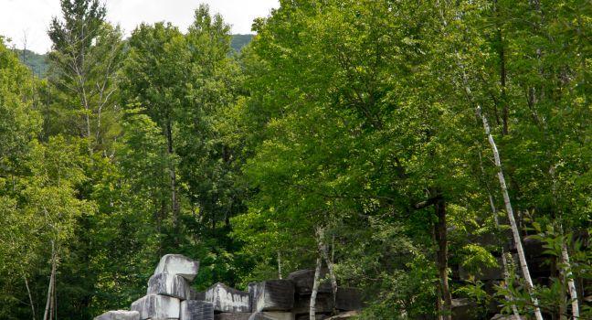
Dorset Quarry
Fodor's Choice
Share This
Lynne Albright / Shutterstock
On hot summer days the sight of dozens of families jumping, swimming, and basking in the sun around this massive 60-foot-deep swimming hole makes it one of the most wholesome and picturesque recreational spots in the region. First mined in 1785, the stone from the country's oldest commercial marble quarry was used to build the main branch of the New York Public Library and the Montreal Museum of Fine Arts.
Bear Lake State Park
Fodor's Choice
Share This
Eight miles wide and 20 miles long, Bear Lake is an unusually radiant shade of blue, thanks to limestone particles suspended in the water. The Utah half of the lake is a state park. Along the south shore of Bear Lake, Highway 30 traces an old route used by Native Americans, mountain men, and settlers following the Oregon Trail. Harsh winters persuaded most settlers to move on before the first snows, but hardy Mormon pioneers settled in the area and founded Garden City. From town you can stroll along a ¼-mile boardwalk through a small wetlands preserve to the lakeshore, and there's a large marina just to the north. The park operates a few other recreation areas along other parts of the shore, including Rendezvous Beach to the south, which has a marina and burger stand, and Cisco Beach on the lake's quieter eastern shore, where the lake bottom drops off quickly, making it a favorite spot among anglers and scuba divers. The lake is home to four species of fish found nowhere else, including the Bonneville cisco, which draws anglers during the January spawning season.
Big Creek Picnic Area
Fodor's Choice
Share This
This is the smallest picnic area in the park, with only 10 picnic tables. The creek is wide and inviting, with small swimming holes and several channels that create tiny islands. The picnic area is accessible via Exit 451 off of Interstate 40 or the unpaved Cove Creek Road from Cataloochee. There's a small campground here and restrooms but no pavilion. Several good hiking trails begin here, and the Appalachian Trail crosses the road near the entrance at Davenport Gap.
Recommended Fodor's Video
Blue Hole
Fodor's Choice
Share This
About 8,000 diving permits are issued per year for folks who strap on tanks and plunge into the 80-foot-deep artesian spring–fed pool at the Blue Hole, which is also open for public swimming during daylight hours (no fee). Cliff diving is great fun here, as is snorkeling and coming face to face with the many koi and goldfish that have been deposited here over the years. The onsite dive shop has tanks, air, weight belts, and a few other basics available to rent. Weekly dive permits are $20; annual permits are $50.
Deep Creek Picnic Area
Fodor's Choice
Share This
Deep Creek offers more than picnicking. You can go tubing (rent a tube for the day for around $5 or $6 at nearby commercial tubing centers), hike about 2 miles to three pretty waterfalls, or go trout fishing. You can even go mountain biking here, as this is one of the few park trails where bikes are allowed. The picnic area, open year-round (but no running water in winter), has 58 picnic tables, plus a pavilion that seats up to 70 (reserve in advance, $32 fee). There's also a campground here.
Hamilton Pool Preserve
Fodor's Choice
Share This
About 30 miles southwest of Austin off Route 71 is a small nature preserve that is home to one of the Hill Country's most beautiful natural pools. The continuously flowing Hamilton Creek spills over an enormous limestone outcropping, creating a beautiful 50-foot waterfall that gently spills into the crystal waters of Hamilton Pool. A popular swimming spot for decades, it's a lovely place to explore and walk. Reservations are required in advance. Entry fees are cash-only in person, credit card online.
Jordan Pond
Fodor's Choice
Share This
Soak up the mountain scenery, listen for the call of loons, and watch for cliff-nesting peregrine falcons along the 3.3-mile trail around this 187-acre tarn—a mountain lake formed by retreating glaciers—north of Seal Harbor on Park Loop Road’s two-way portion. Several carriage roads converge here, one marked by a fanciful gatehouse, one of two on the road network. Visitors fish, kayak, and canoe on the deep water (no swimming) and gaze down on this Great Pond after hiking up nearby mountains. A popular choice is The Bubbles, with twin peaks whose distinct shape makes up for what they lack in size. They rise across the water from Jordan Pond House Restaurant ( 2928 Park Loop Rd.www.jordanpondhouse.com), where folks come for popovers served with strawberry jam and tea, hoping for a table on the expansive lawn—a tradition started in the 1890s in the original Jordan Pond House, which burned in 1979. The rebuild has a two-story gift shop and, on the upper level, an observation deck and Carriage Road Carry Out, with to-go items like sandwiches and salads—or try the popover sundae. Parking lots here fill fast in high season; consider biking or taking the free Island Explorer bus.
Lake Chelan
Fodor's Choice
Share This
Tremendously popular in summer, this narrow, 50-mile-long fjord—Washington's largest natural lake—offers striking scenery year-round. The views take in sparkling blue water with snowcapped peaks in the distance. The lake offers swimming, boating, fishing, and a chance to soak up the sun. By road, the only access to the shore is its southeastern end, but you can explore the rest of the lake by boat.
Lake Cushman
Fodor's Choice
Share This
An 8-mile forest drive from Hoodsport along Highway 119 leads to this 4,000-acre glacial reservoir that hugs the less-visited southeastern border of Olympic National Park. The lake is a gem that's popular with hikers and campers but is also wonderful for canoeing and kayaking (there are a couple of rental outfitters along the shore) as well as fishing for salmon and trout. Relax on the beach or cool off with a dip at Skokomish Park on a summer day, or make your way to nearby Mt. Ellinor Trailhead, where there are both moderate and quite strenuous hikes into the mountains that rise above this glorious lake.
Lake Dillon
Fodor's Choice
Share This
Resting in the heart of Summit County at 9,017 feet is the Front Range's answer to a day at the beach—beautiful Lake Dillon and her two ports, Dillon, just off I–70 on the south, and Frisco, off I–70 and Route 9 on the west. The lake is actually backed up by a 231-foot earth-filled dam that fills the valley where Dillon once sat. During the frequent Western droughts, when water levels can drop dramatically, collectors wander along the exposed shores hunting for artifacts from this Rocky Mountain Atlantis. Below the mile-long dam the Blue River babbles past the outlet shopping haven and turns into miles of gold-medal fly-fishing waters on its journey north. There are more than 27 miles of gravel beaches, marshes, peninsulas, and wooded islets for picnickers to enjoy, many accessible from a 7½-mile paved trail along the northern shores, or from the informal dirt paths elsewhere. Gaze out at the deep blue waters from Sapphire Point Lookout (a short ½-mile hike on the south side of the lake) any nice day, and you'll see a flotilla of motorboats, sailboats, canoes, kayaks, and sailboarders dancing in the waves. In winter the frozen waters are enjoyed by ice anglers and cross-country skiers. Because the lake is a drinking-water source, swimming is not permitted, and the lake is patrolled vigorously by Summit County sheriffs.
Mammoth Lakes Basin
Fodor's Choice
Share This
Mammoth's seven main lakes are popular for fishing and boating in summer, and a network of multiuse paths connects them to the North Village. First comes Twin Lakes, at the far end of which is Twin Falls, where water cascades 300 feet over a shelf of volcanic rock. Also popular are Lake Mary, the largest lake in the basin; Lake Mamie; and Lake George. Horseshoe Lake is the only lake in which you can swim.
Mono Lake
Fodor's Choice
Share This
Since the 1940s, Los Angeles has diverted water from this lake, exposing striking towers of tufa, or calcium carbonate. Court victories by environmentalists have meant fewer diversions, and the lake is rising again. Although to see the lake from U.S. 395 is stunning, make time to visit South Tufa, whose parking lot is 5 miles east of U.S. 395 off Highway 120. There, in summer, you can join the naturalist-guided South Tufa Walk, which lasts about 60 minutes (sign up online).
The Scenic Area Visitor Center, off U.S. 395, is a sensational stop for its interactive exhibits and sweeping Mono Lake views (closed in winter). In town, at U.S. 395 and 3rd Street, the Mono Lake Committee Information Center & Bookstore, open from 9 to 5 daily (extended hours in summer), has more information about this beautiful area.
Newport Harbor
Fodor's Choice
Share This
Sheltering nearly 9,000 small boats, Newport Harbor may seduce even those who don't own a yacht. Spend an afternoon exploring the Newport Beach theme shops and restaurants along the boat slips. Several grassy areas on the primarily residential Lido Isle have views of the water. To truly experience the harbor, rent a kayak or an electric Duffy boat for a pleasant picnic cruise or try stand-up paddleboarding to explore the sheltered waters.
Pack Creek
Fodor's Choice
Share This
More than 90% of Admiralty Island is preserved within the Kootznoowoo Wilderness. Its chief attraction is Pack Creek, where you can watch brown bears feeding on salmon. One of Alaska's premier bear-viewing sites, Pack Creek is comanaged by the U.S. Forest Service and the Alaska Department of Fish and Game. Permits are required during the main viewing season, from April through September. Permits can be processed through www.recreation.gov.
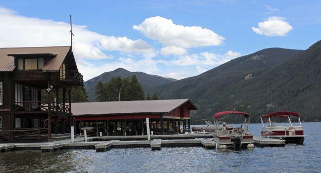
Grand Lake
Share This
Bambi L. Dingman | Dreamstime
The largest and deepest natural lake in Colorado, Grand Lake offers calm waters for boating, fishing, and kayaking. It also feeds into two much larger man-made reservoirs, Lake Granby and Shadow Mountain Lake. These three bodies of water, along with Monarch Lake and Willow Creek and Meadow Creek reservoirs, are called the "Great Lakes of Colorado."
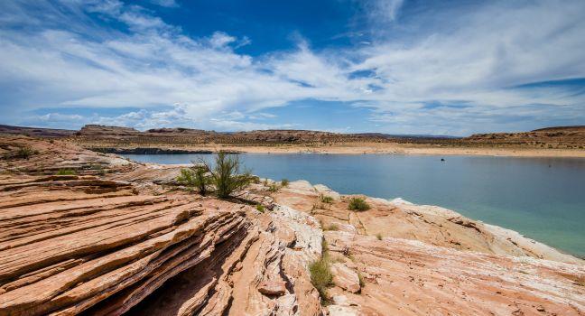
Lake Powell
Share This
COLOMBO NICOLA / Shutterstock
With a shoreline longer than America's Pacific coast, Lake Powell is the heart of the huge 1.25-millon-acre Glen Canyon National Recreation Area. Created by the Glen Canyon Dam—a 710-foot wall of concrete in the Colorado River—Lake Powell took 17 years to fill. The second-largest man-made lake in the nation, it extends through terrain so rugged that it was the last major area of the country to be mapped. Red cliffs ring the lake and twist off into 96 major canyons and countless inlets with huge, red-sandstone buttes randomly jutting from the sapphire waters.
The most popular thing to do at Lake Powell is to rent a houseboat and chug leisurely across the lake, exploring coves and inlets. Like many tourist spots in the region, the lake's busiest times are in the summer, with peak visitation on holiday weekends. Book far in advance for those dates. It's also important to check with the National Park Service for current water levels, closures, and other weather-related conditions.
Southwest of Bullfrog, Rainbow Bridge National Monument is the largest natural bridge in the world, and its 290-foot-high, 275-foot-wide span is a breathtaking sight. Unfortunately, accessing this wonder is difficult. You can either hike a 14-mile trail from the Navajo Nation or boat in, though the National Park Service had to pull its dock back from the water in 2021 due to low water levels and damage from storms, with no estimate for restoring its original location. Small boats and vessels still have access to the shoreline but getting to the trail requires wading through water and mud. No special permit is needed to boat into the monument, but hiking in from the Navajo Nation requires a permit issued by the Navajo Nation Parks and Recreation Department ( www.navajonationparks.org). The main visitor center for Lake Powell is Arizona's Wahweap Marina, with a campground, general store, restaurants, swimming pools, boat docks, and houseboat rentals.
Allagash Wilderness Waterway
Share This
A spectacular 92-mile corridor of lakes, ponds, streams, and rivers, this state-protected waterway cuts through vast commercial forests, beginning near the northwestern corner of Baxter State Park and running north to the town of Allagash, 10 miles from the Canadian border. From May to mid-October, the Allagash is prime canoeing and camping country. The Maine Bureau of Parks and Lands has campsites along the waterway, most not accessible by vehicle. The complete 92-mile course, part of the 740-mile Northern Forest Canoe Trail, which runs from New York to Maine, requires 7–10 days to canoe. Novices may want to hire a guide, as there are areas with strong rapids. A good outfitter can help plan your route and provide equipment and transportation.
Augusta Canal Discovery Center
Share This
Housed in a converted mill in the Augusta Canal National Heritage Area, this museum traces Augusta's important role in developing Georgia's textile industry. The looms are still powered by the building's original turbines; they also provide the power to juice up the museum's Petersburg canal boats. Tours of the canal, usually one hour long, start here and are a fascinating trip through history. Guides are well versed in the passing sights, which include assorted wildlife, a working 19th-century textile mill, and two of Georgia's only remaining 18th-century houses.
Bayou St. John
Bayou St. John
Share This
A bayou is a natural inlet, usually a slow-moving, narrow waterway that emerges from the swamp at one end and joins a larger body of water at the other. This bayou—the only one remaining in New Orleans—borders City Park on the east and extends about 4 miles from Lake Pontchartrain to just past Orleans Avenue. It is named for John the Baptist. June 23 (St. John's Eve, and therefore the day before his feast day) was the most important day in the year for voodoo practitioners, and it was notoriously celebrated on the bayou's banks in the 1800s. The first European settlers in the area, most likely trappers, coexisted with Native Americans here beginning in 1704, and this is the waterway that ships coming from the Gulf of Mexico used to deliver goods into the city center. Today, the bayou is still a popular destination among New Orleanians, whether for tradition's sake—as is the case for the famed Mardi Gras Indians, who gather here for their annual celebrations—for a festival such as the Bayou Boogaloo in May, or simply for a relaxing afternoon of fishing, canoeing, or picnicking along the grassy banks. Scenic biking and walking trails run alongside the waterway all the way to the lake. Follow them and you'll discover a little-known island, a fort in ruins, and the graceful old homes of picturesque Moss Street that morph into the dazzling waterfront mansions of Bancroft Drive.
Beaver Creek
Share This
Rising out of the White Mountains National Recreation Area, Beaver Creek makes its easy way north. If you have enough time, it's possible to run its entire length to the Yukon, totaling 360 river miles if done from road to road. If you make a shorter run, you will have to arrange a takeout via small plane. A lot of people make the trip in five or six days, starting from Nome Creek and taking out at Victoria Creek. Contact CanoeAlaska to schedule a shuttle. Don't try this on your own unless you're an expert in a canoe, and don't forget to pack mosquito repellent.
Birch Creek
Share This
In the Steese National Conservation Area you can take a four- to five-day or 126-mile float trip on the lively, clear-water Birch Creek, a challenge with its several rapids; Mile 94 of the Steese Highway is the access point. Along the way you should see plenty of moose, caribou, and dozens of species of birds. This stream winds its way north through the historic mining country of the Circle District. The first takeout point is the Steese Highway Bridge, 25 miles from Circle. Most people exit here to avoid the increasingly winding river and low water. From there Birch Creek meanders on to the Yukon River well below the town. Fairbanks outfitter CanoeAlaska can arrange shuttles for these trips.
Brooks Lake Recreation Area
Share This
About 20 miles west of Dubois, easy-to-moderate hiking trails lead around Brooks Lake, across alpine meadows, and through pine forest to high mountain points with expansive views of Brooks Lake Mountain and the Pinnacles. You can picnic or (in summer) hard-side camp here, and boat, fish, or swim on the lake.
Brooks River
Share This
Just downstream from Brooks Falls, you can fish for salmon and rainbow trout in Brooks River. Sometimes only fly-fishing is permitted, and there are seasonal closures to prevent contact with bears, so check locally for the latest information.
Copper River Delta
Share This
This 35-mile-wide wetlands complex east of Cordova, a crucial habitat for millions of migratory birds on the Pacific Flyway, is one of North America's most spectacular vistas. The delta's nearly 700,000 acres are thick with marshes, forests, streams, lakes, and ponds. Numerous terrestrial mammals, including moose, wolves, lynx, mink, and beavers, live here, and the Copper River salmon runs are world-famous. When the red and king salmon hit the river in spring, there's a frantic rush to net the tasty fish and rush them off to markets and restaurants all over the country. The delta is connected by the Million Dollar Bridge, an impressive feat of engineering notable for its latticework.
The Forest Service had built an imposing viewing pavilion across the Copper River from Childs Glacier—famous for the spectacle of its calving icebergs and tidal waves—but in 2011, a natural change in the river's flow compromised Bridge 339 at Mile 36, and then several years later it washed out at Mile 44. With every new administration, there are talks of reconstructing the bridge and road, but due to continued budgetary constraints and the hefty price tag of repair, it is unlikely road access will be recreated any time in the near future. The only way to see the glacier now is to book a private helicopter or plane tour or float the 140 miles or so from Chitina. The rules for these float trips are continually changing, but while you're in town, it's worth investigating if there are any motorboat outfitters currently permitted to give rides upriver to the glacier. This difficulty of getting to Childs Glacier has only slightly deterred visitors, as travelers from all over the world still come just to see the awe-inspiring glacier; though in recent years, it has ceased to calve with much frequency due to the receding of the ice and the lowering of river waters.
Curecanti National Recreation Area
Share This
This recreation area, part of the National Park Service, encompasses three reservoirs along 40 miles of the Gunnison River and can be accessed at the bottom of the East Portal Road. Blue Mesa, nearly 20 miles long, is the largest body of water in Colorado; Morrow Point and Crystal are fjordlike reservoirs set in the upper Black Canyon of the Gunnison. All three reservoirs provide water-based recreational opportunities, including fishing, boating, and paddling, but only Blue Mesa offers boat ramps. Excellent fly-fishing can be found upstream (east) of Blue Mesa Reservoir along the Gunnison River. A variety of camping and hiking opportunities are also available. The Elk Creek Visitor Center on U.S. 50 is available year-round for trip-planning assistance. Camping at the Lake Fork Campground in the park provides a perfect middle ground between the North and South Rims of Black Canyon, ideal for seeing both sides over a weekend.
Hammer Slough
Share This
Houses on high stilts and the historic Sons of Norway Hall border this creek that floods with each high tide, creating a photogenic reflecting pool.
Hetch Hetchy Reservoir
Share This
When Congress approved the O'Shaughnessy Dam in 1913, pragmatism triumphed over aestheticism. Some 2½ million residents of the San Francisco Bay Area continue to get their water from this 117-billion-gallon reservoir. Although spirited efforts are being made to restore the Hetch Hetchy Valley to its former, pristine glory, three-quarters of San Francisco voters in 2012 ultimately opposed a measure to even consider draining the reservoir. Eight miles long, the reservoir is Yosemite's largest body of water, and one that can be seen up close from several trails.
Honaunau Bay
Share This
Not technically a beach, this beautiful small bay is an underwater wonderland. Living in and among a wide stretch of lovely coral gardens, yellow tangs, coronet fish, triggerfish, eels, eagle rays, and even Hawaiian green sea turtles make daily appearances. Access is via a lava rock step. Due to its easy access, this spot has seen much overuse in recent years and can get very crowded. Only a few parking spots are available outside the bay as it's also an active fishing launch area. Please visit with the utmost respect to other users of the bay, including residents, canoe club members, fishermen, and others. Please do not stand on coral, use toxic sunscreen, or chase or herd dolphins ($500 fines for violators). Early is best for all conditions—there will be fewer humans and more fish.
Kachemak Bay
Share This
The bay abounds with wildlife, including a large population of puffins and eagles. Tour operators take visitors past bird rookeries or across the bay to gravel beaches for clam digging. Most fishing charters include an opportunity to view whales, seals, porpoises, and birds close-up. At the end of the day, walk along the docks on one of the largest coastal parks in America.
Kaweah Lake
Share This
The Kaweah River rushes out of the Sierra from high above Mineral King in Sequoia National Park. When it reaches the hills above the Central Valley, the water collects in in this lake, a reservoir operated by the Army Corps of Engineers. You can swim, sail, kayak, water ski, hike, camp, fish, and picnic here. The visitor center at Lemon Hill has interesting exhibits about the dam that created the lake.
Subscribe to Newsletter
Sign up for Travel Tips & News
I want emails from Fodor's Travel with travel information and promotions. I can unsubscribe
any time using the unsubscribe link at the end of all emails.
Thank you for your interest!
Look out for our newsletters with travel tips and special offers.
Sign up for Travel Tips & News
By signing up for the
newsletter, I agree to the Privacy Policy. You must check the box to subscribe
Thank you for your interest!
Look out for our newsletters with travel tips and special offers.