


Yosemite from airplane?
 Oct 26th, 2019 | 10:00 AM
#1
Original Poster

Joined: Dec 2009
Posts: 2,159
Likes: 0
Yosemite from airplane?
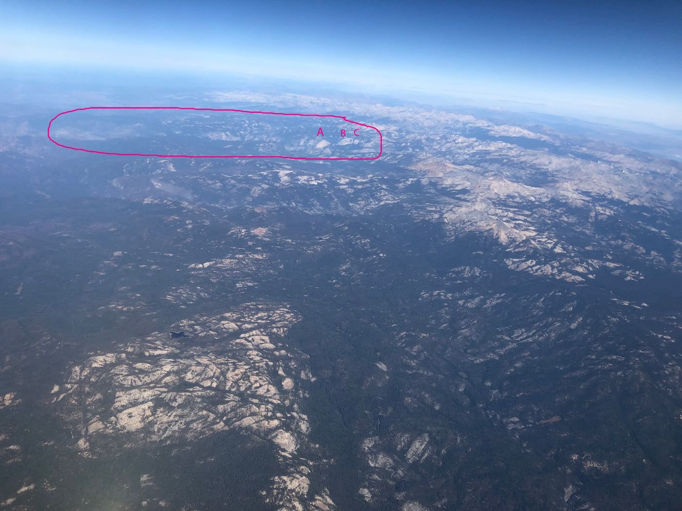
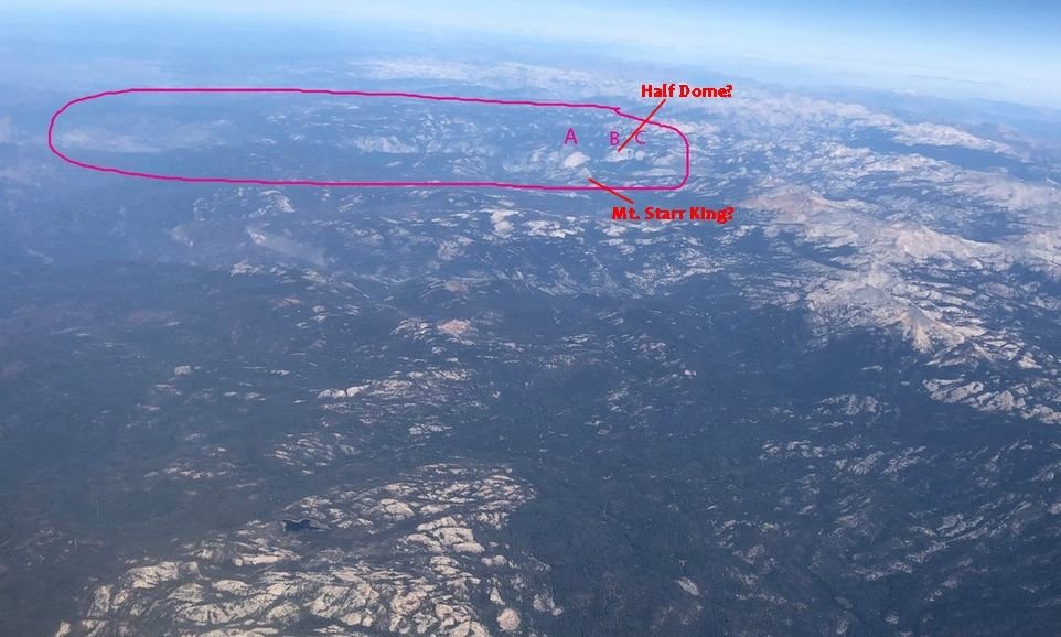
Is this Yosemite Valley circled in pink? For reference Mono Lake is at extreme right, view is from the south looking north.
If this is Yosemite, is A, B, or C Half Dome? Or is it something else?
 Oct 26th, 2019 | 10:20 AM
#2

Joined: Jan 2012
Posts: 12,852
Likes: 26
This is the most useful map I found for your purposes. Half Dome faces more or less north so from the south what you'd see is the dome rather than the face. I'll venture a guess that C is Half Dome. Google Streetview has a very good image standing on Half Dome.

 Oct 26th, 2019 | 08:10 PM
#4
Joined: Jul 2004
Posts: 6,342
Likes: 8
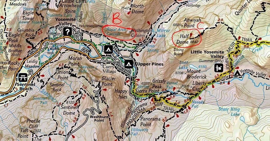
Hard to say for sure but I'll also wager that "C" is Half Dome. "B" could be the big cliff face with Royal Arches that is directly behind the Ahwahnee Hotel.
I have fun with this so here is a map of the valley with a possible B and C labeled, and also a PeakFinder view looking north from south of Yosemite at 30,000+'.
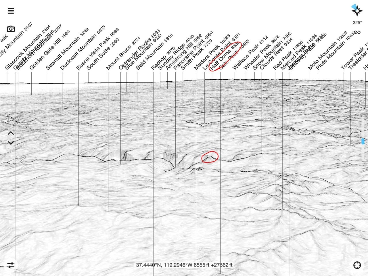
I have fun with this so here is a map of the valley with a possible B and C labeled, and also a PeakFinder view looking north from south of Yosemite at 30,000+'.
Last edited by Nelson; Oct 26th, 2019 at 08:12 PM.
Oct 27th, 2019 | 08:44 AM
#6
Original Poster
Joined: Dec 2009
Posts: 2,159
Likes: 0
Nelson:
Thanks! I love the profile. But studying it I think A matches the profile in your Peakfinder view, a bit flat on the top then more gradual on the sides. Also this places Half Dome where the valley widens out a bit which I think is true. So that leaves B and C to be bald granite mountaintops that appear to loom up but are actually rounded? Not really sure.
Thanks! I love the profile. But studying it I think A matches the profile in your Peakfinder view, a bit flat on the top then more gradual on the sides. Also this places Half Dome where the valley widens out a bit which I think is true. So that leaves B and C to be bald granite mountaintops that appear to loom up but are actually rounded? Not really sure.
Trending Topics
Oct 27th, 2019 | 09:24 AM
#8
Joined: Jul 2004
Posts: 6,342
Likes: 8
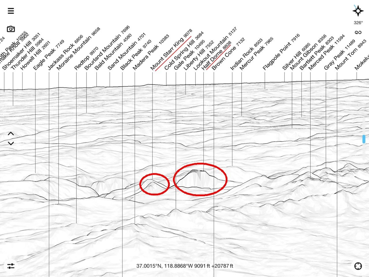
Yeah, I was having doubts too. So I moved the viewpoint farther east and took it to a lower altitude. No doubt I'm still not hat close to your location.
Now I'm thinking "B" is Half Dome and we might be able to see Mt. Starr King getting lined up in your picture. See below. I tried to climb Starr King in 1975 but turned back due to lack of proper experience.
But I think Michelle really nailed it in her first post: "yes, this is Yosemite. Hard to say from this angle which is Half Dome."
In any case, kind of fun to play with this.
Oct 27th, 2019 | 09:39 AM
#9


Joined: Jan 2003
Posts: 26,513
Likes: 4
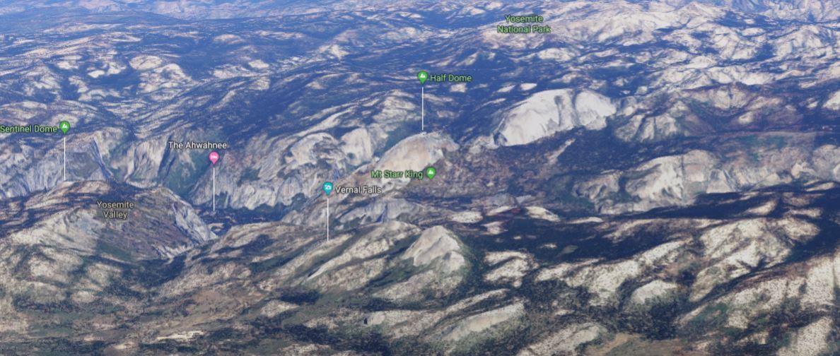
If it helps, here's another aerial view from a different angle. Looking west with Mono Lake at the top. Zoomable..
I also think Half Dome might be A with Washington Column and Royal Arches to the left and North Dome at the left foot of the A. Half Dome's western side slopes gradually, and the eastern side has a 'notch' which I think is visible in tom_mn's aerial view.
https://www.rei.com/adventures/trips...ckpacking.html
Oct 27th, 2019 | 10:03 AM
#10
Original Poster
Joined: Dec 2009
Posts: 2,159
Likes: 0
Thanks for the input, I�ll study these this evening. Flight is the 9:45 am or so United flight Denver to Monterey. If you can line up the Ivanpah circular solar array in SW Nevada with the 40 acre parcel in the Central Valley that spells out Trump in huge letters you will get the flight path.
Last edited by tom_mn; Oct 27th, 2019 at 10:05 AM.
 Oct 27th, 2019 | 06:50 PM
#13
Joined: Jul 2004
Posts: 6,342
Likes: 8
Doing what Jean suggested (great idea) might put Half Dome just to the left of the prominent cliff you are pointing at in your second picture. See screenshot below. Those reddish colored mountains in front in your photo are possibly the Clark Range. There is a Red Peak and Red Peak Pass in there, metamorphic rock instead of granite. The prominent cliff could then be Mount Watkins. (?)
I did a trips to these places in the 70's so am finding this exercise memorably enjoyable.
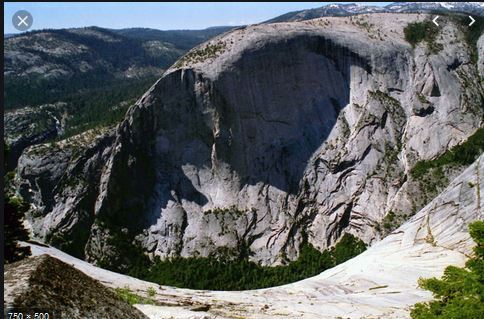
Mount Watkins Yosemite
I did a trips to these places in the 70's so am finding this exercise memorably enjoyable.
Mount Watkins Yosemite
Oct 28th, 2019 | 08:20 AM
#16
Original Poster
Joined: Dec 2009
Posts: 2,159
Likes: 0
So having �seen� Half Dome the only thing left on my California bucket list is a sequoia tree, perhaps satisfied later this week, work load (and wildfire) allowing.
Just kidding, will make a proper Yosemite visit when the waterfalls are flowing.
Just kidding, will make a proper Yosemite visit when the waterfalls are flowing.
Last edited by tom_mn; Oct 28th, 2019 at 08:25 AM.
 Oct 28th, 2019 | 05:19 PM
#19
Joined: Jan 2003
Posts: 26,513
Likes: 4
And then after you've seen the biggest trees on the planet, you have to go see the oldest trees on the planet. Bristlecone Pines. If you had the time, this could be combined with a trip to Yosemite NP.
https://www.bishopvisitor.com/activi...lecone-forest/
https://www.bishopvisitor.com/activi...lecone-forest/

