


The wind, the whiskey and the Wild Atlantic Way
 Sep 4th, 2023 | 04:04 PM
#1
Original Poster

Joined: Jan 2004
Posts: 3,620
Likes: 0
The wind, the whiskey and the Wild Atlantic Way
We just returned from a fantastic trip to Ireland and Northern Ireland during the second half of August.
Last year, United announced a new seasonal route between Chicago and Shannon � and the promos for the Wild Atlantic Way caught our attention. We�ve both been to Ireland previously (and separately) about 30 years ago. In 1992, I did the typical Galway-Dingle-Killarney-Cork-Waterford-Dublin route with family. In 1993, mr_go spent a week in Dublin with his sister when she was in grad school at Trinity. We wanted this trip to be mostly new experiences for both of us. We were particularly interested in visiting Northern Ireland.
Originally, our plan was to fly into Shannon and home from Belfast (Aer Lingus to London, then United home). A week after I purchased tickets, Aer Lingus announced it was pulling out of Belfast, so our return had to change to Dublin.
Our stops:
County Clare: Ennis, near Shannon to acclimate before heading further afield
County Mayo: Westport
County Donegal: Donegal town
Northern Ireland: Giant�s Causeway (more on this later), Belfast
Dublin Airport hotel prior to our morning flight home

On approach to Shannon
Last year, United announced a new seasonal route between Chicago and Shannon � and the promos for the Wild Atlantic Way caught our attention. We�ve both been to Ireland previously (and separately) about 30 years ago. In 1992, I did the typical Galway-Dingle-Killarney-Cork-Waterford-Dublin route with family. In 1993, mr_go spent a week in Dublin with his sister when she was in grad school at Trinity. We wanted this trip to be mostly new experiences for both of us. We were particularly interested in visiting Northern Ireland.
Originally, our plan was to fly into Shannon and home from Belfast (Aer Lingus to London, then United home). A week after I purchased tickets, Aer Lingus announced it was pulling out of Belfast, so our return had to change to Dublin.
Our stops:
County Clare: Ennis, near Shannon to acclimate before heading further afield
County Mayo: Westport
County Donegal: Donegal town
Northern Ireland: Giant�s Causeway (more on this later), Belfast
Dublin Airport hotel prior to our morning flight home
On approach to Shannon
 Sep 4th, 2023 | 04:17 PM
#2
Original Poster
Joined: Jan 2004
Posts: 3,620
Likes: 0
County Clare, part 1
First off, Shannon Airport is probably the fastest and easiest international arrival we�ve had in ages.
Ennis is just 20 minutes away, making it a great base for arrival or departure. It is perennially one of Ireland's "tidiest" towns and just a downright pleasant place to hang out � with some interesting sites in and around the town.

The primary site in Ennis is the Franciscan friary first established in the 13th century - well known for some of its limestone carvings.


We also visited the Dysert O'Dea archaeology center, which includes the ruins of a castle (late 1400s) and church. You have to walk through a cattle pasture (watch your step) to see the church and the ~900-year-old high cross. We were the only people there � just us, the office attendant and a few cows.
O'Dea Castle (you can go in it and climb a few floors up)

900-year-old high cross at Dysert O'Dea

Dysert O'Dea Church

Close-up on the carved doorway
Just a few kilometers to the east of Ennis is Quin Abbey, built in the early 1400s. It has a well-preserved cloister. Again, practically no one there when we visited.

Quin Abbey

Quin Abbey (we saw a lot of ruined abbeys and friaries that looked like this!)

Quin Abbey, preserved cloister
Old Ground Hotel, Ennis: Comfortable, spacious room and fantastic service. We arrived early at 8:30 am expecting to get a room hours later. We left our luggage and set out for a walk. Fifteen minutes later, one of the reception staff called to tell us she�d found a room for us. We tried out a couple of the hotel�s restaurants (Poet�s Corner and Town Hall Bistro) during our stay, which were very good � and the included cooked-to-order breakfast was fantastic.
First off, Shannon Airport is probably the fastest and easiest international arrival we�ve had in ages.
Ennis is just 20 minutes away, making it a great base for arrival or departure. It is perennially one of Ireland's "tidiest" towns and just a downright pleasant place to hang out � with some interesting sites in and around the town.
The primary site in Ennis is the Franciscan friary first established in the 13th century - well known for some of its limestone carvings.
We also visited the Dysert O'Dea archaeology center, which includes the ruins of a castle (late 1400s) and church. You have to walk through a cattle pasture (watch your step) to see the church and the ~900-year-old high cross. We were the only people there � just us, the office attendant and a few cows.
O'Dea Castle (you can go in it and climb a few floors up)
900-year-old high cross at Dysert O'Dea
Dysert O'Dea Church
Close-up on the carved doorway
Just a few kilometers to the east of Ennis is Quin Abbey, built in the early 1400s. It has a well-preserved cloister. Again, practically no one there when we visited.
Quin Abbey
Quin Abbey (we saw a lot of ruined abbeys and friaries that looked like this!)
Quin Abbey, preserved cloister
Old Ground Hotel, Ennis: Comfortable, spacious room and fantastic service. We arrived early at 8:30 am expecting to get a room hours later. We left our luggage and set out for a walk. Fifteen minutes later, one of the reception staff called to tell us she�d found a room for us. We tried out a couple of the hotel�s restaurants (Poet�s Corner and Town Hall Bistro) during our stay, which were very good � and the included cooked-to-order breakfast was fantastic.
Sep 4th, 2023 | 04:20 PM
#3
Original Poster
Joined: Jan 2004
Posts: 3,620
Likes: 0
County Clare, part 2
The Cliffs of Moher are about 45 minutes to the west. We purchased admission online the evening before and got a relatively early start to beat the peak crowds. There were 4 tour buses in the lot when we arrived around 10 am and about 25 when we left. The weather was surprisingly nice - partial clouds and NO wind (not what I recall from my first visit 30 years ago)! We did part of the walk to Doolin.

 \
\


Later, we drove about an hour down the coast to the cliffs at Kilkee - not quite as high, but equally dramatic and without the crowds � or the guardrails. Queue my fear of heights.


The Cliffs of Moher are about 45 minutes to the west. We purchased admission online the evening before and got a relatively early start to beat the peak crowds. There were 4 tour buses in the lot when we arrived around 10 am and about 25 when we left. The weather was surprisingly nice - partial clouds and NO wind (not what I recall from my first visit 30 years ago)! We did part of the walk to Doolin.
\Later, we drove about an hour down the coast to the cliffs at Kilkee - not quite as high, but equally dramatic and without the crowds � or the guardrails. Queue my fear of heights.

 Sep 4th, 2023 | 06:42 PM
#5
Original Poster
Joined: Jan 2004
Posts: 3,620
Likes: 0
County Mayo, part 1
Given that we were traveling at high season, we made the decision to bypass Galway and instead spent three nights in the smaller but colorful Westport. Westport is large enough for a nice walk around and a lively restaurant and pub scene, but not so large that it is hard to navigate in a car, especially early in the trip. It was fairly easy to get in and out of town for our day trips, and to park the car when returning.


Speaking of parking, unless one has a private parking place, street parking and city lots require a small hourly fee between 9:30 am and 6:30 pm - via pay-and-display or the Mayo e-parking app. We used the app and are holding our breath that it worked properly and no parking tickets are forthcoming.
Our rental accommodation here was the favorite of our trip: a recently renovated two-level house on Altamont Street with a lot of space, nice touches and just a five-minute walk from the center of town (Alta House via booking dot com).

We enjoyed dinners at Pantry & Corkscrew and No.8 Tapas Bar. It is a good idea to make reservations a few days in advance, as many restaurants are small. Of course, we popped into a few pubs, including Matt Malloy�s, the famous bar owned by the former member of The Chieftains, but our favorite was probably Toby�s Bar, closer to our rental.
Sep 5th, 2023 | 04:48 AM
#7

Joined: Mar 2003
Posts: 6,205
Likes: 0
I am loving your report and photos! We haven't visited Ireland yet but it's on our travel list. So hopefully in a few years. Looks like you were lucky with the weather much like we were this past June in Scotland. I love your photos of the ruins; I love cathedral ruins, abbey ruins, castle ruins!!! And the Cliffs of Moher - they look stunning! And the sky in your Westport photos add so much to the pictures.
How many nights were you on the ground in Ireland and Northern Ireland? Were you able to drive the entire Wild Atlantic Way?
How many nights were you on the ground in Ireland and Northern Ireland? Were you able to drive the entire Wild Atlantic Way?
Last edited by KarenWoo; Sep 5th, 2023 at 04:54 AM.
Trending Topics
Sep 5th, 2023 | 05:30 AM
#9
Original Poster
Joined: Jan 2004
Posts: 3,620
Likes: 0
Thanks ANUJ, KarenWoo and ChgoGal! Karen, we had 11 nights and 12 days. We did not drive the entire Wild Atlantic Way. Since we were starting in Shannon, we only went as far south as Kilkee. Although we went to Donegal, that is a big area and we only saw some parts of the route there. But the Wild Atlantic Way website was great for planning - we definitely used it to plot out potential places to visit along our route and within the time we had.
County Mayo, part 2
Our first excursion out of Westport was to Achill Island, about an hour to the west and definitely fitting the billing of Wild Atlantic Way. It is one of Ireland�s largest islands, but rather sparsely populated. There are a few roads traversing the island, along the coasts and over passes � occasionally passing through whitewashed towns. It was here that we first encountered �the wind� (but nothing like what was to come), as well as abundant sheep along and occasionally in the road. There wasn�t much traffic, so it was a good place to get comfortable with narrow and winding Irish roads.

Achill Island
We drove a south loop via Dooega, which I believe doubles as a biking route � and I�m not sure we passed another car.

Dooega
That was not to be confused with the beach town of Dooagh, further out on the island, where we stopped for the �loop walk� � an easy 2.7-mile path with views of the mountains and bay.

The Dooagh walking loop starts as a dirt road in town

It winds up above the town, along a small stream

Dooagh

Plenty of wild flowers around

A few residents of Dooagh
There are various walking and hiking trails around the island. With more time, we probably would have hiked to the deserted village. Instead, we enjoyed our picnic lunch on the beach (with the wind).

Back across the Achill Sound and a bit north is Ballycroy Visitor Center, the main information center for Wild Nephin National Park. This is a quite modern structure with some interesting exhibits. There were a few people there, but most seemed to be sticking to the tea room � maybe it was the wind. That didn�t deter us � we got out for a brisk walk around the ~ one-mile nature path. This is a �dark sky� park and apparently a great place for star gazing and photography � if one is staying nearby (which we weren�t) and the sky is clear (how often does that happen?).

Nature Walk at Ballycroy NP visitor center

Along the nature walk, Ballycroy NP
Our last stop of the day was Burrishoole Friary (more commonly called Burrishoole Abbey, but it was Dominican, thus a friary), founded in 1470. Abbeys and friaries were abandoned during the reformation in the 1500s, thus there are many sites like this throughout Ireland -- ruined structures, although the graveyards are still in use.


By the way, this was the day that the GPS (I was the navigator) really began getting a workout. Yes, driving on the other side takes a lot of concentration, but navigating can also require almost constant attention.
County Mayo, part 2
Our first excursion out of Westport was to Achill Island, about an hour to the west and definitely fitting the billing of Wild Atlantic Way. It is one of Ireland�s largest islands, but rather sparsely populated. There are a few roads traversing the island, along the coasts and over passes � occasionally passing through whitewashed towns. It was here that we first encountered �the wind� (but nothing like what was to come), as well as abundant sheep along and occasionally in the road. There wasn�t much traffic, so it was a good place to get comfortable with narrow and winding Irish roads.
Achill Island
We drove a south loop via Dooega, which I believe doubles as a biking route � and I�m not sure we passed another car.
Dooega
That was not to be confused with the beach town of Dooagh, further out on the island, where we stopped for the �loop walk� � an easy 2.7-mile path with views of the mountains and bay.
The Dooagh walking loop starts as a dirt road in town
It winds up above the town, along a small stream
Dooagh
Plenty of wild flowers around
A few residents of Dooagh
There are various walking and hiking trails around the island. With more time, we probably would have hiked to the deserted village. Instead, we enjoyed our picnic lunch on the beach (with the wind).
Back across the Achill Sound and a bit north is Ballycroy Visitor Center, the main information center for Wild Nephin National Park. This is a quite modern structure with some interesting exhibits. There were a few people there, but most seemed to be sticking to the tea room � maybe it was the wind. That didn�t deter us � we got out for a brisk walk around the ~ one-mile nature path. This is a �dark sky� park and apparently a great place for star gazing and photography � if one is staying nearby (which we weren�t) and the sky is clear (how often does that happen?).
Nature Walk at Ballycroy NP visitor center
Along the nature walk, Ballycroy NP
Our last stop of the day was Burrishoole Friary (more commonly called Burrishoole Abbey, but it was Dominican, thus a friary), founded in 1470. Abbeys and friaries were abandoned during the reformation in the 1500s, thus there are many sites like this throughout Ireland -- ruined structures, although the graveyards are still in use.
By the way, this was the day that the GPS (I was the navigator) really began getting a workout. Yes, driving on the other side takes a lot of concentration, but navigating can also require almost constant attention.
Sep 5th, 2023 | 04:22 PM
#10
Original Poster
Joined: Jan 2004
Posts: 3,620
Likes: 0
County Mayo, part 3
Our second excursion from Westport was a rather long but interesting day spent to the southwest of the town. Once again, the wind was whipping � but today we also got a little rain. Knowing the rain was coming, we started with Aasleagh Falls, on the River Erriff just before it meets the fjord. You can see the falls from the road, but it�s much more fun to walk up to it for a closer view. Fortunately, it had been dry for a few days, so the path was not as muddy as it could have been � or probably was several hours later.


Next up was Kylemore Abbey, one of the country�s most popular tourist attractions. We purchased our tickets online the evening before for quicker entry. The former Kylemore Lodge/Castle was the home of doctor and politician Mitchell Henry and his wife, Margaret (until her untimely death), and later the residence of the Duke and Duchess of Manchester. In 1920, it became a Benedictine monastery for nuns who fled from Belgium during World War I. In addition to the main building, the very expansive estate includes the Henrys� mausoleum, a church (we happened in on a harp recital), a pasture with some Connemara ponies, and an expansive walled garden. The rain, of course, started while we were way out in the garden and our raincoats were in the car.

Kylemore Abbey, the iconic shot

Connemara pony in the estate's pasture

Kylemore estate walled garden

Kylemore estate walled garden
By now, we were hungry. I stayed in Clifden on my trip 30 years ago and thought that might be a nice place for lunch � and it would have been, any other week. Unbeknownst to us, we were trying to stop there during the Connemara Pony Show, which draws enthusiasts from all over the world. Just getting through the traffic light in the center of town: 20 minutes. Want to park: ha ha! No telling how busy the restaurants were.

Horse trailers on the road into Clifden should have been a warning
Apple/Google Maps to the rescue: I searched for restaurants a little outside of the town and found the Ardagh Hotel. It was a quiet and lovely place to rest for a bit, and lunch was one of the best of the trip.


Going back through Clifden was not an option, so we concocted a coastal drive to the south. The scenery here is very rocky and almost otherworldly. Of course, taking photos meant getting out of the car to brave the wind, sprinkles and surf spray.


Our last stop was on the Doolough Pass, at the memorial marking the tragic events of the 1849 famine.

Doolough Pass

1849 Famine Memorial
Our second excursion from Westport was a rather long but interesting day spent to the southwest of the town. Once again, the wind was whipping � but today we also got a little rain. Knowing the rain was coming, we started with Aasleagh Falls, on the River Erriff just before it meets the fjord. You can see the falls from the road, but it�s much more fun to walk up to it for a closer view. Fortunately, it had been dry for a few days, so the path was not as muddy as it could have been � or probably was several hours later.
Next up was Kylemore Abbey, one of the country�s most popular tourist attractions. We purchased our tickets online the evening before for quicker entry. The former Kylemore Lodge/Castle was the home of doctor and politician Mitchell Henry and his wife, Margaret (until her untimely death), and later the residence of the Duke and Duchess of Manchester. In 1920, it became a Benedictine monastery for nuns who fled from Belgium during World War I. In addition to the main building, the very expansive estate includes the Henrys� mausoleum, a church (we happened in on a harp recital), a pasture with some Connemara ponies, and an expansive walled garden. The rain, of course, started while we were way out in the garden and our raincoats were in the car.
Kylemore Abbey, the iconic shot
Connemara pony in the estate's pasture
Kylemore estate walled garden
Kylemore estate walled garden
By now, we were hungry. I stayed in Clifden on my trip 30 years ago and thought that might be a nice place for lunch � and it would have been, any other week. Unbeknownst to us, we were trying to stop there during the Connemara Pony Show, which draws enthusiasts from all over the world. Just getting through the traffic light in the center of town: 20 minutes. Want to park: ha ha! No telling how busy the restaurants were.
Horse trailers on the road into Clifden should have been a warning
Apple/Google Maps to the rescue: I searched for restaurants a little outside of the town and found the Ardagh Hotel. It was a quiet and lovely place to rest for a bit, and lunch was one of the best of the trip.
Going back through Clifden was not an option, so we concocted a coastal drive to the south. The scenery here is very rocky and almost otherworldly. Of course, taking photos meant getting out of the car to brave the wind, sprinkles and surf spray.
Our last stop was on the Doolough Pass, at the memorial marking the tragic events of the 1849 famine.
Doolough Pass
1849 Famine Memorial
Sep 6th, 2023 | 08:15 AM
#12
Original Poster
Joined: Jan 2004
Posts: 3,620
Likes: 0
County Sligo
There�s plenty to see and do in County Sligo, but unfortunately this was just a stopping point on our journey north. We made a quick visit to Sligo town for lunch and enjoyed our walk around. Like Ennis, Sligo has a prominent (ruined) abbey that has dominated the center for hundreds of years (since 1253). As you can see from a few photos, one moment it was bright and sunny � and then suddenly it wasn�t.

Sligo

Sligo
Sligo Abbey, founded in 1253
One of the most anxiety-inducing aspects of this trip was the thought of driving into cities, on the �wrong� side of the road and trying to navigate traffic and find a place to park. For Sligo, we did our research the evening before, identifying various public parking lots and then picking one. That made it really easy. I programmed it into the GPS, and Siri led us right there. On the GPS note, every address in Ireland has a unique 7-character Eircode for mapping directions.
Many of the public parking lots and spaces we used were pay-and-display (although not very expensive). Some took credit cards, and some didn�t. Sometimes the credit card worked, and sometimes it didn�t. It�s a good idea to always have a few 1- and 2-euro coins.
We also stopped a bit north of Sligo for the Benbulben Forest Walk � which has great views of this distinctive rock formation. We didn�t have time for the full 6-mile loop, but we enjoyed a portion of it. It looks nice and sunny in the photos, but by now the wind was �hold on to your hat� intense.

Benbulben, the distinctive table rock formation

Part of the Benbulben forest walk
Next stop: Donegal.
There�s plenty to see and do in County Sligo, but unfortunately this was just a stopping point on our journey north. We made a quick visit to Sligo town for lunch and enjoyed our walk around. Like Ennis, Sligo has a prominent (ruined) abbey that has dominated the center for hundreds of years (since 1253). As you can see from a few photos, one moment it was bright and sunny � and then suddenly it wasn�t.
Sligo
Sligo
Sligo Abbey, founded in 1253
One of the most anxiety-inducing aspects of this trip was the thought of driving into cities, on the �wrong� side of the road and trying to navigate traffic and find a place to park. For Sligo, we did our research the evening before, identifying various public parking lots and then picking one. That made it really easy. I programmed it into the GPS, and Siri led us right there. On the GPS note, every address in Ireland has a unique 7-character Eircode for mapping directions.
Many of the public parking lots and spaces we used were pay-and-display (although not very expensive). Some took credit cards, and some didn�t. Sometimes the credit card worked, and sometimes it didn�t. It�s a good idea to always have a few 1- and 2-euro coins.
We also stopped a bit north of Sligo for the Benbulben Forest Walk � which has great views of this distinctive rock formation. We didn�t have time for the full 6-mile loop, but we enjoyed a portion of it. It looks nice and sunny in the photos, but by now the wind was �hold on to your hat� intense.
Benbulben, the distinctive table rock formation
Part of the Benbulben forest walk
Next stop: Donegal.
Sep 6th, 2023 | 03:51 PM
#15
Original Poster
Joined: Jan 2004
Posts: 3,620
Likes: 0
Thank you all - Paqngo, maitaitom and zebec! The title was a collaborative effort.
zebec, I am NOT done - some of the best moments of this trip are yet to come. The megalithic dolmen in the middle of a cow pasture. The Troubles. The Giant's Causeway. And the whiskey. Stay tuned.
zebec, I am NOT done - some of the best moments of this trip are yet to come. The megalithic dolmen in the middle of a cow pasture. The Troubles. The Giant's Causeway. And the whiskey. Stay tuned.
Sep 6th, 2023 | 05:38 PM
#16
Joined: Mar 2003
Posts: 6,205
Likes: 0
Wow! Your photos and narrative are amazing! Maybe I missed it in your narrative, but how did you get to Achil Island? Bridge, causeway, ferry? Love the photos of the sheep, and the scenery is so moody and evocative. Love the nature walk at Ballycroy NP. Your walks look like they are primarily flat. Am I right? Just my speed!
Kylemore Abbey is stunning! The scenery on your coastal drive, as you say, is otherworldly. And love the colorful buildings in Sligo.
Kylemore Abbey is stunning! The scenery on your coastal drive, as you say, is otherworldly. And love the colorful buildings in Sligo.
Sep 7th, 2023 | 07:04 AM
#18
Original Poster
Joined: Jan 2004
Posts: 3,620
Likes: 0
KarenWoo and J62 - thank you!
Karen, you can drive onto Achill Island. There's a bridge over the sound, which is pretty narrow at that point. These walks were flat. We like to hike, but we didn't do anything too strenuous. We didn't really plan this to be much of a hiking trip because we know the weather is fickle, and we didn't want to be stuck somewhere on a remote trail or up a mountain in an unexpected rainstorm.
J62, I'll try to move this along faster (but work....).
County Donegal, part 1
Our base for this part of the trip was Donegal town � in a cozy two-level house, via Airbnb, with a nice backyard space (when weather cooperated). We especially liked the location � less than five minutes on foot to the �Diamond� and the easy parking right in front.

Our cozy house in Donegal town

It even came with a back yard
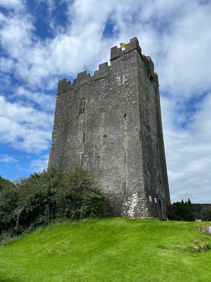
There�s a lot of history right in town. We could practically see Donegal Castle � built by Red Hugh O�Donnell as his personal fortress in the 1400s and now largely restored � from our rental.

Donegal Castle (now significantly restored)

Walking on some very old floors (castle origins in the 1400s)

The 16th C fireplace is one of the notable features of Donegal Castle
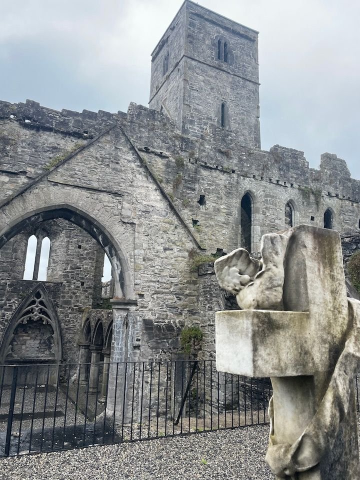
Ruins of the Franciscan friary, of similar origin, are on the outskirts, overlooking the bay.

Donegal's Franciscan friary - also called Donegal Abbey
But I won�t lie. Our best memories might be the pubs. Live music every night at The Reel Inn. And our own little place, several doors down on Meetinghouse Street, The Forge. Of course, there was some whiskey involved.

Our neighborhood pub

American police and fire badges on the walls in many Irish bars and pubs

Live music at The Reel Inn (wish I could post the video)
Karen, you can drive onto Achill Island. There's a bridge over the sound, which is pretty narrow at that point. These walks were flat. We like to hike, but we didn't do anything too strenuous. We didn't really plan this to be much of a hiking trip because we know the weather is fickle, and we didn't want to be stuck somewhere on a remote trail or up a mountain in an unexpected rainstorm.
J62, I'll try to move this along faster (but work....).
County Donegal, part 1
Our base for this part of the trip was Donegal town � in a cozy two-level house, via Airbnb, with a nice backyard space (when weather cooperated). We especially liked the location � less than five minutes on foot to the �Diamond� and the easy parking right in front.
Our cozy house in Donegal town
It even came with a back yard
There�s a lot of history right in town. We could practically see Donegal Castle � built by Red Hugh O�Donnell as his personal fortress in the 1400s and now largely restored � from our rental.
Donegal Castle (now significantly restored)
Walking on some very old floors (castle origins in the 1400s)
The 16th C fireplace is one of the notable features of Donegal Castle
Ruins of the Franciscan friary, of similar origin, are on the outskirts, overlooking the bay.
Donegal's Franciscan friary - also called Donegal Abbey
But I won�t lie. Our best memories might be the pubs. Live music every night at The Reel Inn. And our own little place, several doors down on Meetinghouse Street, The Forge. Of course, there was some whiskey involved.
Our neighborhood pub
American police and fire badges on the walls in many Irish bars and pubs
Live music at The Reel Inn (wish I could post the video)
Sep 7th, 2023 | 07:16 AM
#19
Original Poster
Joined: Jan 2004
Posts: 3,620
Likes: 0
County Donegal, part 2
We had two days for some excursions from Donegal town. This website has some great information for visiting Donegal, including six suggested driving itineraries with maps and details on where to stop:
https://www.govisitdonegal.com/thing.../scenic-routes
We covered a lot of the territory in routes 1 and 2, and wish we�d had time for more. Several of these drives are probably better from a more northerly base.
Truly the highlight of our two days of meandering in Donegal was Sliabh Liag (Slieve League), with some of the highest sea cliffs in Europe. This site is at least as dramatic as the Cliffs of Moher, but without the crowds. Yes, there were people there, but the parking lot holds a few dozen cars rather than a few hundred. In peak season, parking (�5) is in the lower lot, and the walk to the viewing areas takes about a half hour via the road to the upper lot � with nice views along the way. I understand it may be possible to drive to the upper lot at non-peak times but don�t know the details. There are various hiking trails around the site that may have tempted us on a different day � but we didn�t really have the time, or the inclination to hike in a wildly whipping wind.

It's a 30-minute or so walk from the Sliabh Liag parking lot to the viewing areas

Lobster rolls at the top - we were tempted but had brought our own lunch

The cliffs at Sliabh Liag

These sheep have a great view
Afterward, we took a drive north of those cliffs to the scenic areas around Malinmore and the beach at Malin Beg, and then back to Donegal town via the Glengesh Pass.

Near Mailinmore

The beach at Malin Beg - what you can't see here is just how windy it was!

Glengesh pass
We had two days for some excursions from Donegal town. This website has some great information for visiting Donegal, including six suggested driving itineraries with maps and details on where to stop:
https://www.govisitdonegal.com/thing.../scenic-routes
We covered a lot of the territory in routes 1 and 2, and wish we�d had time for more. Several of these drives are probably better from a more northerly base.
Truly the highlight of our two days of meandering in Donegal was Sliabh Liag (Slieve League), with some of the highest sea cliffs in Europe. This site is at least as dramatic as the Cliffs of Moher, but without the crowds. Yes, there were people there, but the parking lot holds a few dozen cars rather than a few hundred. In peak season, parking (�5) is in the lower lot, and the walk to the viewing areas takes about a half hour via the road to the upper lot � with nice views along the way. I understand it may be possible to drive to the upper lot at non-peak times but don�t know the details. There are various hiking trails around the site that may have tempted us on a different day � but we didn�t really have the time, or the inclination to hike in a wildly whipping wind.
It's a 30-minute or so walk from the Sliabh Liag parking lot to the viewing areas
Lobster rolls at the top - we were tempted but had brought our own lunch
The cliffs at Sliabh Liag
These sheep have a great view
Afterward, we took a drive north of those cliffs to the scenic areas around Malinmore and the beach at Malin Beg, and then back to Donegal town via the Glengesh Pass.
Near Mailinmore
The beach at Malin Beg - what you can't see here is just how windy it was!
Glengesh pass
Sep 7th, 2023 | 07:36 AM
#20
Joined: Mar 2004
Posts: 2,725
Likes: 0
I'm loving your trip report so far and the pictures are absolutely stunning. Your report is very timely, as was the one recently posted by AlessandraZoe. I'm planning a trip to Ireland for next September, but since I'll be traveling solo I'll be doing it with Rabbie's as I'm not comfortable with the idea of driving it alone, especially on the opposite side of the road from which I'm used to.
Looking forward to the rest of your report.
Looking forward to the rest of your report.

