11 Best Sights in Moab and Southeastern Utah, Utah

Bears Ears National Monument

Fodor's choice

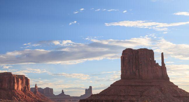
Named for its striking pair of massive buttes, Bears Ears National Monument stretches across more than a million acres of land sacred to several Native American tribes. Countless archaeological sites and artifacts dot this remote landscape, including cliff dwellings, petroglyphs, pictographs, and a prehistoric road system. The scenery is awe-inspiring, too, with remote canyons, vast grasslands, and the kind of towering red-rock formations southern Utah is famous for. Opportunities abound here to hike, rock climb, river raft, and embark on scenic drives, and visitor information is available at both the U.S. Bureau of Land Management and U.S. Forest Service offices in Monticello. Because of the long history that surrounds you in Bears Ears, being especially respectful of your surroundings is a must. In Bluff, the Bears Ears Education Center offers further guidance on how to explore such a culturally important area. 

While entering the monument is free, permits and passes are required in the Shash Jáa Special Recreation Management Area and the Cedar Mesa Special Recreation Management Area. Depending on the time of year, these can be purchased at trailheads or at  www.recreation.gov. The hike to Moon House, an Ancestral Puebloan dwelling, is so popular that only 20 hikers are allowed per day and a separate permit is required.

Dead Horse Point State Park

Fodor's choice

One of the gems of Utah's state park system, right at the edge of the Island in the Sky section of Canyonlands, this park overlooks a sweeping oxbow of the Colorado River some 2,000 feet below. Dead Horse Point itself is a small peninsula connected to the main mesa by a narrow neck of land. As the story goes, cowboys used to drive wild mustangs onto the point and pen them there with a brush fence. There's a nice visitor center with a coffee shop and museum. The park's Intrepid trail system is popular with mountain bikers and hikers alike. If it's a nice day, be sure to walk the 4-mile rim trail loop and drive to the park's eponymous point.

Buy Tickets Now

Monument Valley Navajo Tribal Park

Fodor's choice
Monument Valley Navajo Tribal Park
Guoqiang Xue / Shutterstock

For the most breathtaking (and recognizable) views of the iconic West, this is the place. The soaring red buttes, eroded mesas, deep canyons, and naturally sculpted rock formations found here are an easy 21-mile drive south of Mexican Hat on U.S. 163 across Navajo land. Monument Valley is a small part of the more-than-7-million acre Navajo Reservation and is sacred to the Navajo Nation, or Diné (pronounced din-eh, which means "the people"), as they refer to themselves. For generations, the Navajo have grown crops and herded sheep in Monument Valley, considered to be one of the most scenic and mesmerizing destinations in the Navajo Nation. Director John Ford made this fantasy land of buttes, towering rock formations, and mesas popular when he filmed Stagecoach here in 1938.

The 90,000-acre Monument Valley Navajo Tribal Park lies within Monument Valley. A 17-mile self-guided driving tour on a dirt road (there's only one road, so you can't get lost) passes the memorable Mittens and Totem Pole formations, among others. Drive slowly, and be sure to walk (15 minutes round-trip) from North Window around the end of Cly Butte for the views. Call ahead for road conditions in winter. The Monument Valley visitor center has a small crafts shop and exhibits devoted to ancient and modern Native American history. Most of the independent guided tours here use enclosed vans and you will usually be approached in the parking lot; you can find about a dozen approved Navajo Native American guides in the center. They will escort you to places you are not allowed to visit on your own. This surreal landscape constantly changes with the rising and setting sun.

Buy Tickets Now

Recommended Fodor's Video

Valley of the Gods

Fodor's choice

A red fairyland of slender spires and buttes, the Valley of the Gods is a smaller version of Monument Valley. Approximately 15 miles west of Bluff, you can take a pretty drive through this relatively unvisited area on 17-mile-long Valley of the Gods Road, which begins on U.S. 163 and ends on Highway 261. The road is unpaved but should be drivable as long as it's dry.

Carl's Critter Garden

It's impossible to miss this delightfully weird roadside collection of massive scrap-metal sculptures, from huge dinosaurs to tiny, buglike creatures. The longer you stay, the more details you see, and somehow the small sign reading "Welcome to the Center of the Universe" feels right on. The "garden" promotes love and is free, though it does take donations in a little box. 

Goblin Valley State Park

Hundreds of orange, mushroom-like rocks known as "hoodoos" rise up from the desert floor about 30 miles northwest of Hanksville. Short, easy trails wind through the bizarre goblins making it a fun walk for kids and adults. Be forewarned that during busy times of the year, there may be a wait time to enter the park.

Buy Tickets Now

Goosenecks State Park

Stare down the spectacular, 1,000-foot cliffs, and you can see how this remote park got its name: the San Juan River's serpentine course resembles the necks of geese. Geologists also say this is the best example of an "entrenched meander" in the world, including rock 300 million years old. The nighttime skies here are legendary, and in 2021 Goosenecks officially became an International Dark Sky Park, a recognition from the International Dark Sky Association. Camping sites are all first-come, first-served. You'll find the park 8 miles northwest of Mexican Hat off Highway 261. 

Green River State Park

A shady respite on the banks of the Green River, this park is best known for its golf course. It's also the starting point for boaters drifting along the river through Labyrinth and Stillwater Canyons. Fishing and bird-watching are other favorite pastimes here.

Hovenweep National Monument

The best place in southeast Utah to see ancient tower ruins dotting the scenic cliffs, if you're headed south from Canyonlands and have an interest in Ancestral Puebloan culture, a visit to this monument is a must. Park rangers strongly advise following printed maps and signs from U.S. 191 near Blanding, Utah, or County Road G from Cortez, Colorado; GPS is not reliable here. Once you arrive, you'll find unusual tower structures (which may have been used for astronomical observation) and ancient dwellings.

Lake Powell

Lake Powell
COLOMBO NICOLA / Shutterstock

With a shoreline longer than America's Pacific coast, Lake Powell is the heart of the huge 1.25-millon-acre Glen Canyon National Recreation Area. Created by the Glen Canyon Dam—a 710-foot wall of concrete in the Colorado River—Lake Powell took 17 years to fill. The second-largest man-made lake in the nation, it extends through terrain so rugged that it was the last major area of the country to be mapped. Red cliffs ring the lake and twist off into 96 major canyons and countless inlets with huge, red-sandstone buttes randomly jutting from the sapphire waters.

The most popular thing to do at Lake Powell is to rent a houseboat and chug leisurely across the lake, exploring coves and inlets. Like many tourist spots in the region, the lake's busiest times are in the summer, with peak visitation on holiday weekends. Book far in advance for those dates. It's also important to check with the National Park Service for current water levels, closures, and other weather-related conditions.

Southwest of Bullfrog, Rainbow Bridge National Monument is the largest natural bridge in the world, and its 290-foot-high, 275-foot-wide span is a breathtaking sight. Unfortunately, accessing this wonder is difficult. You can either hike a 14-mile trail from the Navajo Nation or boat in, though the National Park Service had to pull its dock back from the water in 2021 due to low water levels and damage from storms, with no estimate for restoring its original location. Small boats and vessels still have access to the shoreline but getting to the trail requires wading through water and mud. No special permit is needed to boat into the monument, but hiking in from the Navajo Nation requires a permit issued by the Navajo Nation Parks and Recreation Department ( www.navajonationparks.org). The main visitor center for Lake Powell is Arizona's Wahweap Marina, with a campground, general store, restaurants, swimming pools, boat docks, and houseboat rentals.

Sego Canyon Rock Art Interpretive Site

Sego is one of the most dramatic and mystifying rock-art sites in the entire state. Large, ghostlike rock-art figures painted and etched by Native Americans approximately 4,000 years ago cover these canyon walls. There's also art left by the Ute from the 19th century. Distinctive for their large anthropomorphic figures, and for horses, buffalo, and shields painted with red-and-white pigment, these rare drawings are a must-see. A well-preserved ghost town is also nearby.