Get FREE email communications from Fodor's Travel, covering must-see travel destinations, expert
trip planning advice, and travel inspiration to fuel your passion.
We've compiled the best of the best in USA - browse our top choices for the top
things to see or do during your stay.
Sorry! We don't have any recommendations for USA right now.
Sights Filter
Rankin Ridge Drive (North Entrance)
Fodor's Choice
Share This
Entering the park across the north border via Highway 87 is perhaps the most beautiful drive into the park. As you leave behind the grasslands and granite spires of Custer State Park and enter Wind Cave, you see the prairie, forest and some of the oldest rock in the Black Hills. The silvery twinkle of mica, quartz, and feldspar crystals dots Rankin Ridge east of Highway 87, and gradually gives way to limestone and sandstone formations.
Rim Drive
Fodor's Choice
Share This
Take this 33-mile scenic loop for views of the lake and its cliffs from every conceivable angle. The drive takes two hours, not counting frequent stops at overlooks and short hikes that can easily stretch this to a half day. Rim Drive is typically closed due to heavy snowfall from late fall to late spring.
Rogue-Umpqua River Scenic Byway
Fodor's Choice
Share This
Roseburg is the starting point for this dramatic route that climbs east as Highway 138 alongside the North Umpqua Wild and Scenic River through dense stands of old-growth Douglas fir and hemlock trees and into the Cascade Range for about 80 miles to the northern (summer only) entrance to Crater Lake National Park. Just after Diamond Lake, the route turns southwest via Highways 230, 62, and 234 along a stunning stretch of the Rogue River, before ending northeast of Medford in tiny Eagle Point. Allow six to nine hours to drive the entire 172-mile route, taking time to stop here and there to enjoy the scenery, and perhaps even hike some portions of the North Umpqua Trail. Signposted trailheads along the drive lead to some magnificent waterfalls—Deadline Falls and Fern Creek Falls are a couple of favorites. Note that this route differs from the Umpqua River Scenic Byway, a stretch of Highway 138 that can access 15 miles north of Roseburg in Oakland and follow 66 miles as it twists and turns over the Coast Range—through famous fishing holes and rugged timber towns—to Reedsport on the central coast.
Recommended Fodor's Video
Ross Maxwell Scenic Drive
Fodor's Choice
Share This
Although it extends only 30 miles, you can easily spend a full day on this winding ribbon of blacktop soaking up soaring alpine views, exploring historic sites, taking short hikes, and earning a true Big Bend education. There are scenic overlooks, a magnificent western perspective of the Chisos Mountains, informative exhibit signs, and the ruins of old homesteads. Top waysides along this route that don't take more than a half-hour or so to explore include Sam Nail Ranch, the remains of an adobe homestead in a shady grove with a creek that draws myriad birdlife; Sotol Vista, a grand promontory with sweeping views of the southwestern side of the park (including Santa Elena Canyon); and Tuff Canyon, a striking steep-walled volcanic-rock canyon. Slightly longer but highly worthwhile excursions include the 1-mile round-trip hike into a green valley to Blue Creek Ranch (aka Homer Wilson Ranch), and the 1-mile round-trip ramble to Lower Burro Mesa Pouroff, a sheer box canyon reached via a 1½-mile side road. Mile Ears Viewpoint, which entails a 4-mile round-trip hike to a gurgling desert spring, is another intriguing side adventure. If you have plenty of time and don't mind driving on a bumpy, washboard gravel road (high-clearance vehicles are best for this drive), you can make this drive a loop by reconnecting with West Entrance Road (near Highway 118) from Santa Elena Canyon via unpaved Old Maverick Road for 14 miles—allow an hour for this road, and avoid it if you're driving an RV or there's been a lot of rain.
San Juan Skyway
Fodor's Choice
Share This
One of the country's most stupendously scenic drives, the 236-mile San Juan Skyway weaves through an impressive series of Fourteeners (peaks reaching more than 14,000 feet). From Telluride, it heads north on Route 145 to Placerville, where it turns east on Route 62. On U.S. 550 it continues south to historic Ouray and over Red Mountain Pass to Silverton and then on to Durango, Mancos, and Cortez via U.S. 160. From Cortez, Route 145 heads north, passing through Rico and over lovely Lizard Head Pass before heading back into Telluride. In late September and early October, this route has some of the state's most spectacular aspen viewing.
Skyline Drive
Fodor's Choice
Share This
Alternating between wide-open vistas and forest-hemmed stretches, Skyline Drive offers 105 miles of easily accessible wilderness. Designated as a National Historic Landmark, the winding two-lane scenic byway runs from Front Royal in the north to Waynesboro in the south. On weekends and holidays, in particular, a 35-mph speed limit, rubber-necking leaf-lookers, small overlook pull-offs, and the occasional black bear sighting can cause cars to inch along Skyline Drive. It's best to choose a weekday and give yourself a full day to explore; you may want to spend an hour or two simply savoring the views from a roadside boulder.
Spirit Lake Highway
Fodor's Choice
Share This
Officially known as Highway 504, this winding road rises 4,000 feet from the town of Castle Rock (just off I–5, Exit 49) to within about 5 miles of the Mt. St. Helens summit. Visitor centers along the way explain the region's geology and geography, and several turnouts afford views of the destruction wrought upon the Toutle and Cowlitz river valleys.
Tony Grove Lake and Naomi Peak
Fodor's Choice
Share This
From Logan, U.S. 89 continues for 30 miles up Logan Canyon before topping out at the crest of the Bear River Range (from which it continues another 10 miles to Bear Lake). For a particularly satisfying excursion that leads to awesome hiking and mountain biking, drive the well-signed 7-mile side road to Tony Grove Lake. At more than 8,000 feet, this subalpine jewel is surrounded by cliffs and meadows filled in summer with a stunning profusion of wildflowers. A short trail circles the lake. Mountain bikers and hikers alike can access a prime wilderness area via the 3.3-mile one-way route from the lake to the 9,984-foot summit of Naomi Peak, which offers 80-mile views on clear days. With a gain almost 2,000 feet in elevation, the hike passes through conifer forests and open meadows and along subalpine basins and rocky ledges. A shorter hike to White Pine Lake, which begins on the same trail and splits after a quarter of a mile, is also lovely.
Utah Scenic Byway 24
Fodor's Choice
Share This
A roughly 15-mile section of this 65-mile designated byway between Loa and Hanksville passes right through the heart of Capitol Reef National Park. Colorful rock formations in all their hues of red, cream, pink, gold, and deep purple extend from one end of the route to the other. The landscape is most colorful within the park, but the views are pretty impressive the entire route, even as you continue through the lush green mountains west of Loa.
Valley of the Gods
Fodor's Choice
Share This
A red fairyland of slender spires and buttes, the Valley of the Gods is a smaller version of Monument Valley. Approximately 15 miles west of Bluff, you can take a pretty drive through this relatively unvisited area on 17-mile-long Valley of the Gods Road, which begins on U.S. 163 and ends on Highway 261. The road is unpaved but should be drivable as long as it's dry.
Volcanic Legacy Scenic Byway
Fodor's Choice
Share This
The byway is a 500-mile scenic drive connecting Lassen with Oregon's Crater Lake National Park. The route's southern loop begins in Chester and winds for about 185 miles through the forests, volcanic peaks, hydrothermal springs, and lava fields of Lassen National Forest and Lassen Volcanic National Park. The all-day excursion into dramatic wilderness includes a detour north to 129-foot-tall Burney Falls. Note, though, that the Dixie Fire of 2021 scorched the forested areas along Highway 36 and Lassen National Park Highway near Chester.
Wallowa Mountain Loop
Fodor's Choice
Share This
This is a relatively easy way to take in the natural splendor of the Eagle Cap Wilderness and reach Baker City without backtracking to La Grande. The loop is a segment of the Hells Canyon Scenic Byway, which continues for a three-and-a-half hour trip from Joseph to Baker City. It winds through the national forest and part of Hells Canyon National Recreation Area, passing over forested mountains, creeks, and rivers. Before you travel the byway, check with the Forest Service about road conditions; the route can be impassable when snowed over. From Joseph, take Highway 350 east for 8 miles, turn south onto Forest Service Road 39, and continue until it meets Highway 86, which winds past the town of Halfway and then continues to Baker City.
West Cliff Drive
Fodor's Choice
Share This
The road that winds along an oceanfront bluff from the municipal wharf to Natural Bridges State Beach makes for a spectacular drive, but it's even more fun to walk or bike the paved path that parallels the road. Surfers bob and swoosh in Monterey Bay at several points near the foot of the bluff, especially at a break known as Steamer Lane. Named for a surfer who died here in 1965, the nearby Mark Abbott Memorial Lighthouse stands at Point Santa Cruz, the cliff's major promontory. From here you can watch pinnipeds hang out, sunbathe, and frolic on Seal Rock.
Zion Canyon Scenic Drive
Fodor's Choice
Share This
Vividly colored cliffs tower 2,000 feet above the road that meanders north from Highway 9 at Canyon Junction along the floor of Zion Canyon. As you roll through the narrow, steep canyon, you'll pass The Court of the Patriarchs, The Sentinel, and The Great White Throne, among other imposing rock formations. From roughly March through November, unless you're staying at the lodge, you can access Zion Canyon Scenic Drive only by riding the park shuttle. The rest of the year, you can drive it yourself.
Antelope Flats Road
Share This
RIRF Stock / Shutterstock
Off U.S. 191/26/89, about 2 miles north of Moose Junction, this narrow road wanders eastward over sagebrush flats, intersecting with the gravel lane to the Mormon Row Historic District. Less than 2 miles past here is a three-way intersection where you can turn right to loop around past the tiny hamlet of Kelly and Gros Ventre campground and rejoin the main highway at Gros Ventre Junction. Keep an eye out for abundant and swift pronghorn, along with bison, foxes, raptors, and more than a few cyclists.
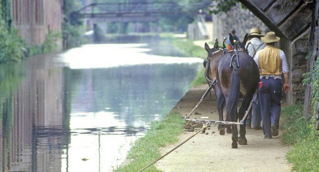
C&O Canal
Georgetown
Share This
spirit of america / Shutterstock
George Washington was one of the first to advance the idea of a canal linking the Potomac with the Ohio River across the Appalachians. Work started on the Chesapeake & Ohio Canal in 1828. When it opened in 1850, its 74 locks linked Georgetown with Cumberland, Maryland, 185 miles to the northwest (still short of its intended destination). Lumber, coal, iron, wheat, and flour moved up and down the canal, but it was never as successful as its planners had hoped, due to damaging floods and competition from the Baltimore & Ohio Railroad. Today the canal is part of the National Park System; walkers and cyclists follow the towpath once used by mules, while canoeists paddle the canal's calm waters. During the summer months, visitors can go on a boat tour of the canal at the Great Falls Tavern Visitor Center (a 30-minute drive from Georgetown), where tour guides share the canal's history and operate the canal locks and boat just as they would have in the 1870s. Tours are free, but visitors must reserve one hour beforehand.
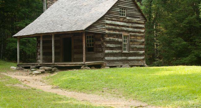
Cades Cove Loop Road
Share This
George Allen Penton / Shutterstock
This 11-mile loop through Cades Cove is the most popular route in the park and arguably the most scenic part of the Smoky Mountains. The one-way, one-lane paved road starts 7.3 miles from the national park's Townsend entrance. The drive begins with views over wide pastures to the mountains at the crest of the Smokies. Few other places in the Appalachians offer such vistas across wide valleys with hayfields and wildflower meadows framed by split-rail fences and surrounded by tall mountains. Along the way, you'll pass three 19th-century churches and many restored houses and barns that are open for exploration. A highlight is the Cable Mill area, with a visitor center, working water-powered gristmill, and a restored farmstead. The Cades Cove Loop Road is also an excellent place to see wildlife, including black bears, white-tailed deer, and wild turkeys.
Whenever you visit, even in winter, you can expect traffic delays, as passing points on the one-way road are few and far between. Allow at least two to three hours to drive the loop—longer if you want to stop and explore the historic buildings. If you get frustrated with delays, there are two points where you can cut across the loop on improved gravel roads, exiting sooner. A campground and picnic area are open year-round. The road is closed from sunset to sunrise.
La Sal Mountain Loop
Share This
EastVillage Images / Shutterstock
With beautiful lakes and welcoming shade, these mountains outside Moab offer cool relief from the desert's hot summers and striking scenery as the aspen leaves turn gold in the fall. On Old Airport Road (a left turn off U.S. 191) 8 miles south of Moab, the 62-mile loop climbs over the laccolith mountain range, affording some great vistas of the valley. The road enters La Sal Division of the Manti-La Sal National Forest just as the dominant red-rock cliffs east of Moab begin to alternate with sagebrush and juniper flats. Passing through the cool heights of La Sal Mountains, the loop winds north through red rock country to Castle Valley and an intersection with Highway 128. The road is paved, except for a couple of gravel sections, but it has steep switchbacks, and it does become snow-packed in winter. Check with the National Forest Service before embarking on winter driving on this road as some sections may be closed.
Lower Colorado River Scenic Byway—Highway 279
Share This
IrinaK / Shutterstock
If you're interested in Native American rock art, Highway 279 northwest of Moab is a perfect place to spend a couple of hours immersed in the past. To get there, go north from Moab on U.S. 191 for about 3½ miles before turning left onto Highway 279. If you start late in the afternoon, the cliffs will be glowing orange as the sun sets. Along the first part of the route you'll see signs reading "Indian Writings." Park only in designated areas to view the petroglyphs on the cliff side of the road. At the 18-mile marker you'll see Jug Handle Arch. A few miles beyond this point the road turns to four-wheel-drive only and takes you into the Island in the Sky District of Canyonlands. Do not continue onto Island in the Sky unless you are in a high-clearance four-wheel-drive vehicle with a full gas tank and plenty of water. Allow about two hours round-trip for the scenic byway drive.
If you happen to be in Moab during a heavy rainstorm, Highway 279 is also a good option for viewing the amazing waterfalls caused by rain pouring off the cliffs on both sides of the Colorado River.
Peak to Peak Scenic and Historic Byway
Share This
Maomaotou | Dreamstime.com
The byway (Routes 119, 72, and 7), a 55-mile stretch that winds from Central City north through Nederland to Estes Park, is not the quickest route to the eastern gateway to Rocky Mountain National Park, but it's certainly the most scenic. You'll pass through the old mining towns of Ward and Allenspark and enjoy spectacular mountain vistas. Mt. Meeker and Longs Peak rise magnificently behind every bend in the road. The descent into Estes Park provides grand vistas of snow-covered mountains and green valleys.
Alpine Loop Scenic Byway
Share This
The inspiring 63-mile Alpine Loop Scenic Byway joins Lake City with Ouray and Silverton. The road, typically open late May or early June through early October, has unpaved sections that require a high-clearance, four-wheel-drive vehicle. Dizzily spiraling from 12,800-foot-high passes to gaping valleys, past seven ghost towns, the trip is well worth the effort.
Apgar Village to Polebridge (Camas Road and North Fork Road)
Share This
The 25-mile journey to the tiny community of Polebridge involves travel along a gravel road that has a few potholes, but the scenery along the north fork of the Flathead River makes up for the bumpy ride. Be on the lookout for wildlife, and be sure to stop for a snack at the Polebridge Mercantile and Bakery.
Artist's Bridge
Share This
Built in 1872 and pedestrian-only since 1958, the most painted and photographed of Maine's nine covered bridges can be found north of Bethel in neighboring Newry. From U.S. 2, turn onto Sunday River Road (watch for signs; stay to the right at the "Y" intersections). The 87-foot-long Paddleford truss bridge is aside the modern one that handles road traffic these days. A popular swimming spot, folks put in by the old wood bridge or follow the path from its south end to a bend in the river.
Baker Creek Road
Share This
Though less popular than the Wheeler Peak Scenic Drive, this gravel road has beautiful views of Wheeler Peak, the Baker Creek Drainage, and Snake Valley. Vibrant wildflowers are an extra treat in spring and early summer. The road is closed in the winter, and there are no pull-outs or scenic overlooks.
Bald Hills Road
Share This
This steep, dramatic road winding up to some of the parks' highest elevations accesses great hikes—Lady Bird Johnson Grove and Lyons Ranch among them—as well as the spur road to Tall Trees Grove. But it's wondrously scenic all on its own, passing through a sometimes misty redwood patch before reaching open meadows with wildflowers in spring and the chance to see Roosevelt elk and bears year-round. Do stop at Redwood Creek Overlook, a 2,100-foot elevation pullout at mile 6.6. Bald Hills Road is paved for the first 13 miles. It continues another 4 miles unpaved to RNSP's southern boundary. From here you can continue another 20 miles or so to the small village of Weitchpec and then onward inland toward Redding or Yreka.
Battle Highway
Share This
As you make your way west to Baggs over the Battle Highway (Route 70), you'll cross the Continental Divide and the Rocky Mountains. This route takes you through the mining country that was developed during the 1897–1908 copper-mining boom in the Sierra Madres; interpretive signs along the way point out historic sites. Legend has it that in 1878, Thomas Edison was fishing near Battle Pass with a bamboo rod when he began to ponder the idea of a filament, which led to his invention of the incandescent light bulb. Note that this section of the highway closes to car travel in winter, though it stays open for snowmobiles.
Bear Lake Road
Share This
This 23-mile round-trip drive offers superlative views of Longs Peak (14,259-foot summit) and the glaciers surrounding Bear Lake, winding past shimmering waterfalls shrouded with rainbows. You can either drive the road yourself (open year-round) or hop on one of the park's free shuttle buses.
Bison Flats Drive (South Entrance)
Share This
Entering the park from the south on U.S. 385 takes you past Gobbler Ridge and into the hills commonly found in the southern Black Hills region. After a couple of miles, the landscape gently levels onto the Bison Flats, one of the mixed-grass prairies on which the park prides itself. You might see a herd of grazing bison (the park has between 450 and 550 of them) between here and the visitor center. You can also catch panoramic views of the parklands, surrounding hills, and limestone bluffs.
Blue Ridge Parkway
Share This
The Blue Ridge Parkway takes up where Skyline Drive leaves off at Waynesboro, weaving south for 469 miles to the Great Smoky Mountains National Park in North Carolina. The parkway goes up to higher elevations than the drive, up to 4,200 feet at Apple Orchard Mountain, and even higher in North Carolina. In Virginia the parkway is especially scenic between Waynesboro and Roanoke, winding through the George Washington National Forest, visiting numerous ridgetop overlooks that provide views of crumpled-looking mountains and patchwork valleys.
Milepost 0 is at Rockfish Gap. There are no gas stations on the parkway, so you'll have to exit if you need to refuel, and be prepared for a leisurely drive as the speed limit is 45 mph. Go to the Visitor Center at Explore Park, open 9–5 daily year-round, 1.5 miles north of milepost 115 near Roanoke, or call the National Park Service's office in Vinton (540/857–2490) for information on Virginia's section of the parkway.
Blueberry Hill
Share This
About a half mile beyond the Schoodic Point spur on the scenic one-way loop drive, this spot looks out on nearby Little Moose and Schoodic Islands and the ocean beyond. It’s also where to park if you’re planning to hike a loop consisting of the Alder and Anvil trails across the road from the parking lot.
Subscribe to Newsletter
Sign up for Travel Tips & News
I want emails from Fodor's Travel with travel information and promotions. I can unsubscribe
any time using the unsubscribe link at the end of all emails.
Thank you for your interest!
Look out for our newsletters with travel tips and special offers.
Sign up for Travel Tips & News
By signing up for the
newsletter, I agree to the Privacy Policy. You must check the box to subscribe
Thank you for your interest!
Look out for our newsletters with travel tips and special offers.