107 Best Sights in USA

Background Illustration for Sights

We've compiled the best of the best in USA - browse our top choices for the top things to see or do during your stay.

Cliff Palace

Fodor's Choice
Cliff Palace, Mesa Verde National Park;
Bryan Brazil / Shutterstock

This was the first major Mesa Verde dwelling seen by cowboys Charlie Mason and Richard Wetherill in 1888. It is also the largest, containing about 150 rooms and 23 kivas on three levels. Getting there involves a steep downhill hike and three ladders.  You may enter Balcony House or Cliff Palace by ranger-guided tour only so purchase tickets in advance.

The 90-minute, small-group "twilight tours" at sunset present this archaeological treasure with dramatic sunset lighting. Tour tickets are only available in advance at the Visitor and Research Center, Morefield Ranger Station, Durango Welcome Center, and online at  www.recreation.gov.

Mesa Verde National Park, CO, 81330, USA
Sight Details
Regular tickets $3; twilight tours $20
Closed Oct./Nov.--late May; loop closes at sunset

Something incorrect in this review?

Indian Canyons

Fodor's Choice
Murray Canyon, with indigenous palms in Palm Canyon, Palm Springs, California, home of Cahuilla peoples
Joseph Sohm / Shutterstock

The Indian Canyons are the ancestral home of the Agua Caliente Band of Cahuilla Indians. While hiking three canyons open to the public, you can see remnants of their ancient life, including rock art, house pits and foundations, irrigation ditches, dams, and food-preparation areas. Trails vary in length from 1.2 to 4.7 miles long, are classified as easy or moderate, and are lined with palm oases, waterfalls, rock formations, and, in spring, wildflowers. Tree-shaded picnic areas are abundant.

The Trading Post at the entrance to Palm Canyon, noted for its stand of Washingtonia palms, has trail maps and refreshments as well as Native American crafts. Endangered Peninsular Bighorn Sheep call Murray Canyon home. Fan palms and tall willows contrast with strange rock formations in Andreas Canyon. Ranger-led hikes and talks are included with paid admission, but only they occur from October through June. Note that no animals are allowed. While exploring the canyons, remember you are a guest amid the still-sacred tribal lands.

Monument Valley Navajo Tribal Park

Fodor's Choice
View of buttes and mesas of Monument Valley Navajo Tribal Park
Guoqiang Xue / Shutterstock

For the most breathtaking (and recognizable) views of the iconic West, this is the place. The soaring red buttes, eroded mesas, deep canyons, and naturally sculpted rock formations found here are an easy 21-mile drive south of Mexican Hat on U.S. 163 across Navajo land. Monument Valley is a small part of the more-than-7-million acre Navajo Reservation and is sacred to the Navajo Nation, or Diné (pronounced din-eh, which means "the people"), as they refer to themselves. For generations, the Navajo have grown crops and herded sheep in Monument Valley, considered to be one of the most scenic and mesmerizing destinations in the Navajo Nation. Director John Ford made this fantasy land of buttes, towering rock formations, and mesas popular when he filmed Stagecoach here in 1938.

The 90,000-acre Monument Valley Navajo Tribal Park lies within Monument Valley. A 17-mile self-guided driving tour on a dirt road (there's only one road, so you can't get lost) passes the memorable Mittens and Totem Pole formations, among others. Drive slowly, and be sure to walk (15 minutes round-trip) from North Window around the end of Cly Butte for the views. Call ahead for road conditions in winter. The Monument Valley visitor center has a small crafts shop and exhibits devoted to ancient and modern Native American history. Most of the independent guided tours here use enclosed vans and you will usually be approached in the parking lot; you can find about a dozen approved Navajo Native American guides in the center. They will escort you to places you are not allowed to visit on your own. This surreal landscape constantly changes with the rising and setting sun.

Recommended Fodor's Video

Taos Pueblo

Fodor's Choice
UNESCO World Heritage Site Taos Pueblo outside of Taos, New Mexico, continuously inhabited for over 1000 years.
photogal / Shutterstock

For nearly 1,000 years, the mud-and-straw adobe walls of Taos Pueblo have sheltered Tiwa-speaking Native Americans. A United Nations World Heritage Site, the multistory Pueblo is the largest of its kind. The pueblo's main buildings, a north house and a south house, are separated by the Rio Pueblo de Taos, a river that originates high in the mountains at the sacred Blue Lake, the primary source of Taos Pueblo’s drinking and irrigation water. These two structures are believed to have been built between 1000 and 1450. The mica-flecked adobe walls are maintained by continuously refinishing them with new plaster and clay washes. Some walls are several feet thick in places. The roofs of each of the five-story structures are supported by large timbers, or vigas, hauled down from the mountain forests, with smaller pieces of pine or aspen latillas placed between the vigas. To finish the roof, it is packed full of dirt.

Taos Pueblo has retained 95,000 acres of its original homeland. Forty-eight thousand acres of this was won back from the U.S. government through Taos Pueblo’s historic legal fight for the return of Blue Lake. Tribal custom allows no electricity or running water in the two houses of the ancient Pueblo, where varying members (roughly 150) of Taos Pueblo live full-time. An additional 1,900 or so live in homes outside of the ancient pueblo. The pueblo also has schools, cemeteries, a health center, farms and fields, buffalo pastures, powwow grounds, and many religious dwellings including traditional kivas and the Catholic Church of San Geronimo.

Although the population is predominantly Catholic, the people of Taos Pueblo also maintain their original religious traditions. The public is invited to certain ceremonial and social dances held throughout the year: highlights include the Feast of Santa Cruz (May 3); Taos Pueblo Pow Wow (mid-July); Santiago and Santa Ana Feast Days (July 25 and 26); San Geronimo Days (September 29 and 30); Procession of the Virgin Mary (December 24); and Deer Dance or Matachines Dance (December 25). While you're at the pueblo, respect all rules and customs, which are posted prominently. There are some restrictions on personal photography. Guided tours are available daily and are the best way to start your visit. Tours are led Taos Pueblo community members and provide insight into both the history and present-day life of the Pueblo.

Acoma Pueblo

Fodor's Choice

Atop a 367-foot mesa that rises abruptly from the valley floor, Acoma Pueblo's terraced, multistory, multiunit Sky City is like no other pueblo structure. It's one of the oldest continually inhabited spots in North America, with portions believed to be more than 1,500 years old. Captain Hernando de Alvarado, a member of Francisco Vásquez de Coronado's expedition of 1540, was the first European to see Acoma. He reported that he had "found a rock with a village on top, the strongest position ever seen in the world." The Spanish eventually conquered the Acoma people and brutally compelled them to build San Estéban del Rey, the immense adobe church that stands to this day. Native American laborers cut the massive vigas for the church's ceiling 30 mi away on Mt. Taylor and physically carried them back to the mesa.

About a dozen families live at the mesa-top pueblo full time, with most other Acomas living on Native American land nearby and returning only in summer and for celebrations, such as the feast day of St. Stephen (September 2), and Christmas mass (both are open to the public). Acoma's artisans are known for their thin-walled pottery, hand-painted with intricate black-and-white or polychrome geometrical patterns.

Once you park at the mesa base, plan to spend time in the superb Haak'u Museum at the Sky City Cultural Center. Changing exhibits explore traditional and contemporary arts, and are perfectly set in this modernist interpretation of traditional pueblo forms, with fine sandstone detailing and glass panels prepared to evoke historic mica windows. Visitation on the mesa top is by an hour-long guided tour; you're whisked by van up a steep road from behind the center and then led about the mesa community on foot (allow extra time if you choose to walk back down instead, via the ancient staircase carved into the side of the mesa). An Acoma guide will point out kivas, hornos, and unforgettable views toward their sacred sites of Enchanted Mesa and Mt. Taylor, and describe pueblo history in-depth, as well as direct you to artisan displays throughout the village. (Note: the terrain can be uneven; heeled shoes or flip-flops are not advised.) There's no electricity or running water in the village, but you can see cars parked outside many homes—one wonders what it must have been like to visit Acoma before the road was constructed in 1969. Open hours vary slightly, depending on the weather. Videotaping, sketching, and painting are prohibited, and a permit is required for still photography. Note that the pueblo prohibits photography of the church interior and exterior as well as the adjoining cemetery. As at all indigenous locales, ask permission before photographing residents or their artwork. Regroup back at Haak'u and browse the gallery gift shop and bookstore or enjoy blue-corn pancakes or a grilled chicken wrap with green-chile guacamole at the cozy Y'aak'a (Corn) Café. There is shuttle service available if you are staying at the Sky City Hotel/Casino (888/759–2489). Open hours are subject to tribal activities or weather conditions; it is best to check their online calendar or call ahead.

Acoma Pueblo, NM, 87034, USA
505-552–6604
Sight Details
Pueblo tour $12, Haak'u Museum $4
Apr.–Oct., museum daily 9–6, Pueblo tours daily 9–5 (last full tour leaves at 4); Nov.–Mar., museum daily 9–5, tours daily 8–4. The café closes 1 hr before the museum.

Something incorrect in this review?

Alaska Native Heritage Center

East Anchorage Fodor's Choice

On a 26-acre site facing the Chugach Mountains, this facility provides an introduction to Alaska Native peoples. The spacious Gathering Place has interpretive displays, artifacts, photographs, demonstrations, Alaska Native dances, storytelling, and films, along with a gift shop selling crafts and artwork. Step outside for a stroll around the adjacent lake, where seven village exhibits represent the traditional structures of Alaska Native cultural groups. Inside, you'll find tools, games, and innovations used in the past, plus hosts and storytellers during the summer months. The Center is tucked in the woods on the edge of town, but a shuttle runs June through August to connect guests to the Log Cabin Visitors Center and Anchorage Museum Downtown.

Balcony House

Fodor's Choice

The stonework of this 40-room cliff dwelling is impressive, but you're likely to be even more awed by the skill it must have taken to reach this place. Perched in a sandstone cove 600 feet above the floor of Soda Canyon, Balcony House seems suspended in space. Even with modern passageways and trails, today's visitors must climb a 32-foot ladder and crawl through a narrow tunnel. Look for the intact balcony for which the house is named. The dwelling is accessible only on a ranger-led tour.

Bandelier National Monument

Fodor's Choice

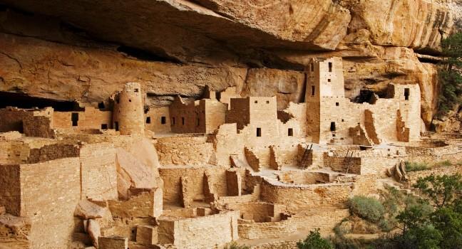
Seven centuries before the Declaration of Independence was signed, compact city-states existed in the Southwest. This 33,677-acre wilderness is home to a fascinating collection of preserved petroglyphs and cave dwellings of the Ancestral Puebloan people, relatives of today's Rio Grande Pueblo Indians, who thrived on wild game, corn, and beans. Suddenly, for reasons still undetermined, the settlements were abandoned.

Remnants of one of the most impressive examples of these dwellings can be seen at Frijoles Canyon. At the canyon's base, near a gurgling stream, the remains of cave dwellings, ancient ceremonial kivas, and other stone structures stretch out for more than a mile beneath the sheer walls of the canyon's tree-fringed rim. Along a paved, self-guided trail, steep wooden ladders and narrow doorways lead to a series of cave dwellings, one that contains a kiva large and tall enough to stand in. Named after author and ethnologist Adolph Bandelier (his novel The Delight Makers is set in Frijoles Canyon), it also contains backcountry wilderness, waterfalls, and wildlife. Some 70 miles of trails traverse the park; the short Pueblo Loop Trail is an easy, self-guided walk. Pick up the $2 trail guide at the visitor center to read about the numbered sites along this trek. A small museum in the visitor center interprets the area's prehistoric and contemporary Native American cultures, with displays of artifacts dating back to the 13th century.

Note that from mid-June to mid-October, visitors arriving by car between 9 am and 3 pm must park at the White Rock Visitor Center 10 miles east on NM 4 and take a free shuttle bus into the park. This sleek, eco-friendly visitor center also serves as a terrific resource for learning about local attractions. The modern, comfortable Hampton Inn & Suites Los Alamos is next door.

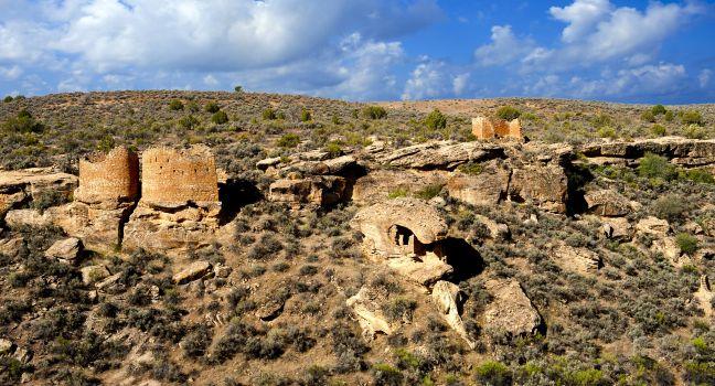
One section of the park, an Ancestral Puebloan ruin called Tsankawi (pronounced sank-ah-wee) lies 12 miles from the main section, on NM 4 just south of NM 502 (because it is part of Bandelier, you must pay the park admission to enter it). On the 1½-mile loop trail, you can see petroglyphs and south-facing cave dwellings, and there's a large, unexcavated pueblo ruin on top of the mesa.

Bears Ears National Monument

Fodor's Choice

Named for its striking pair of massive buttes, Bears Ears National Monument stretches across more than a million acres of land sacred to several Native American tribes. Countless archaeological sites and artifacts dot this remote landscape, including cliff dwellings, petroglyphs, pictographs, and a prehistoric road system. The scenery is awe-inspiring, too, with remote canyons, vast grasslands, and the kind of towering red-rock formations southern Utah is famous for. Opportunities abound here to hike, rock climb, river raft, and embark on scenic drives, and visitor information is available at both the U.S. Bureau of Land Management and U.S. Forest Service offices in Monticello. Because of the long history that surrounds you in Bears Ears, being especially respectful of your surroundings is a must. In Bluff, the Bears Ears Education Center offers further guidance on how to explore such a culturally important area. 

While entering the monument is free, permits and passes are required in the Shash Jáa Special Recreation Management Area and the Cedar Mesa Special Recreation Management Area. Depending on the time of year, these can be purchased at trailheads or at  www.recreation.gov. The hike to Moon House, an Ancestral Puebloan dwelling, is so popular that only 20 hikers are allowed per day and a separate permit is required.

Canyon de Chelly

Fodor's Choice

Home to Ancestral Pueblo from AD 350 to 1300, the nearly 84,000-acre Canyon de Chelly (pronounced d'shay) is one of the most spectacular natural wonders in the Southwest. On a smaller scale, it rivals the Grand Canyon for beauty. Its main gorges—the 26-mile-long Canyon de Chelly ("canyon in the rock") and the adjoining 35-mile-long Canyon del Muerto ("canyon of the dead")—comprise sheer, heavily eroded sandstone walls that rise to 1,100 feet over dramatic valleys. Ancient pictographs and petroglyphs decorate some of the cliffs, and within the canyon complex there are more than 7,000 archaeological sites. Stone walls rise hundreds of feet above streams, hogans, tilled fields, and sheep-grazing lands.

You can view prehistoric sites near the base of cliffs and perched on high, sheltering ledges, some of which you can access from the park's two main drives along the canyon rims. The dwellings and cultivated fields of the present-day Navajo lie in the flatlands between the cliffs, and those who inhabit the canyon today farm much the way their ancestors did. Most residents leave the canyon in winter but return in early spring to farm.

Canyon de Chelly's South Rim Drive (37 miles round-trip with seven overlooks) starts at the visitor center and ends at Spider Rock Overlook, where cliffs plunge nearly 1,000 feet to the canyon floor. The view here is of two pinnacles, Speaking Rock and Spider Rock. Other highlights on the South Rim Drive are Junction Overlook, where Canyon del Muerto joins Canyon de Chelly; White House Overlook, from which a 2½-mile round-trip trail leads to the White House Ruin, with remains of nearly 60 rooms and several kivas; and Sliding House Overlook, where you can see dwellings on a narrow, sloped ledge across the canyon. The carved and sometimes narrow trail down the canyon side to White House Ruin is the only access into Canyon de Chelly without a guide—if you have a fear of heights, this may not be the hike for you.

The only slightly less breathtaking North Rim Drive (34 miles round-trip with three overlooks) of Canyon del Muerto also begins at the visitor center and continues northeast on Indian Highway 64 toward the town of Tsaile. Major stops include Antelope House Overlook, a large site named for the animals painted on an adjacent cliff; Mummy Cave Overlook, where two mummies were found inside a remarkably unspoiled pueblo dwelling; and Massacre Case Overlook, which marks the spot where an estimated 115 Navajo were killed by the Spanish in 1805. (The rock walls of the cave are still pockmarked by the Spaniards' ricocheting bullets.)

Canyons of the Ancients National Monument

Fodor's Choice

Spread across 176,000 acres of arid mesa and canyon country, the Canyons of the Ancients National Monument holds more than 20,000 archaeological sites, the greatest concentration anywhere in the United States. Some sites, like apartment-style cliff dwellings and hewn-rock towers, are impossible to miss. Others are as subtle as the remains of agricultural fields, springs, and water systems. They are powerful evidence of the complex civilization of the Ancestral Pueblo people. Lowry Pueblo, in the northern part of the monument, is a 40-room pueblo with eight kivas (round chambers used for sacred rituals). Its Great Kiva is one of the largest known in the Southwest.

Exploring the monument area can be a challenge: roads are few, hiking trails are sparse, and visitor services are all but nonexistent. The visitor center, which is also a museum, is 3 miles west of Dolores on Route 184. The best bet is a guided hike with the nonprofit Southwest Colorado Canyons Alliance ( www.swcocanyons.org/tours).

27501 Rte. 184, Dolores, CO, 81321, USA
970-882–5600
Sight Details
Monument free; museum $3

Something incorrect in this review?

Dry Fork Canyon

Fodor's Choice

An impressive array of Native American petroglyphs and pictographs adorn the 200-foot-high cliffs in Dry Fork Canyon, making the 22-mile round-trip drive from Vernal well worth your time. Two trails leading to the rock art are on McConkie Ranch, a privately owned property that asks only for a $5 per vehicle donation and respect for the site. Make sure to bring sturdy shoes because both short paths have steep and rough spots. If you call the ranch's number, Jean McConkie McKenzie, who was born and still lives here, will show you her collection of arrowheads and antiques. Her mother, Sadie, first opened the rock art to the public in 1930.

3500 Dry Fork Canyon Rd., Vernal, UT, 84078, USA
435-789–6733
Sight Details
$5 per vehicle donation requested

Something incorrect in this review?

Gila Cliff Dwellings National Monument

Fodor's Choice

At Gila Cliff Dwellings National Monument the mystery of the Mogollon (muh-gee-yohn) people's short-lived occupation of the deeply recessed caves high above the canyon floor may never be resolved. But the finely detailed stone dwellings they left behind stand in silent testimony to the challenges as well as the beauty of the surrounding Gila Wilderness. Built and inhabited for a span of barely two generations, from 1280 to the early 1300s AD, its 42 rooms are tucked into six natural caves that are reached via a rugged one-mile loop trail that ascends 180 feet from the trail head. Constructed from the same pale volcanic stone as the cliffs themselves, the rooms are all but camouflaged until you are about a half-mile along the trail. You can contemplate, from a rare close-up vantage point, the keyhole doorways that punctuate the dwelling walls and gaze out upon a ponderosa pine- and cottonwood-forested terrain that looks much like the one the Mogollon people inhabited seven centuries ago. The wealth of pottery, yucca sandals, tools, and other artifacts buried here were picked clean by the late 1800s—dispersed to private collectors. But the visitor center has a small museum with books and other materials about the wilderness, its trails, and the Mogollon. It's a 2-mile drive from the visitor center to the Dwellings trail head (and other nearby trails); there are interesting pictographs to be seen on the wheelchair-accessible Trail to the Past.

Allow a good 2 hours from Silver City to the Cliff Dwellings via NM 15 or via NM 35; though longer in mileage, the NM 35 route is an easier ride.

If you can spare the time, spend the night at one of the mountain inns close to the dwellings to maximize your time in the park.

Hibulb Cultural Center & Natural History Preserve

Fodor's Choice

This impressive contemporary museum and cultural center with a stunning cedar longhouse, intricate wood carvings, hand-crafted canoes, and engaging interactive exhibits reveals the rich history of the several tribes—including Snohomish, Skykomish, and Snoqualmie—that have thrived in the Puget Sound region for centuries. The center adjoins a 50-acre nature preserve with stands of cedar and hemlock trees, salmon-rich streams, preserved estuarial wetlands, and nature trails. Just off Interstate 5 near the town of Marysville, the waterfront Tulalip Reservation has more than 2,500 tribal members and is also home to the 370-room Tulalip Resort Casino and an outlet shopping center, which are just a few miles north of the cultural center.

Makah Cultural and Research Center

Fodor's Choice

Thousands of Makah artworks and artifacts, some dating back to the 16th century, fill a dramatically lighted space that's the perfect backdrop for the intriguing exhibits. The centerpiece is a full-size cedar longhouse, complete with handwoven baskets, fur skins, cattail wool, and grass mats on the bed planks, with tribal music playing in the background. Another section showcases full-size whaling and seal-hunting canoes and weapons. Other areas show games, clothing, crafts, and relics from the ancient Ozette Village mudslide. The small but particularly good museum shop stocks a collection of locally made art crafts.

Mashantucket Pequot Museum & Research Center

Fodor's Choice

Housed in a large complex 1 mile from Foxwoods, this museum brings to life in exquisite detail the history and culture of the Northeastern Woodland tribes in general and the Mashantucket Pequots in particular. Highlights include views of an 18,000-year-old glacial crevasse, a caribou hunt from 11,000 years ago, and a 17th-century fort. Perhaps most remarkable is a sprawling "immersion environment": a 16th-century village with more than 50 life-size figures and real smells and sounds. Audio devices provide detailed information about the sights. A full-service restaurant offers both Native and traditional American cuisine. A 185-foot stone-and-glass tower provides sweeping views of the surrounding countryside.

Medicine Wheel/Medicine Mountain National Historic Landmark

Fodor's Choice

A ring of rocks 75 feet in diameter, this ancient site is the best preserved of nearly 150 Native American stone wheels found in Wyoming, South Dakota, Montana, Alberta, and Saskatchewan. Evidence such as the 28 spokes (one for each day of the lunar cycle) leading from the edge of the wheel to a central cairn has persuaded some that the wheel was an ancient spiritual observatory much like England's Stonehenge may have been. To protect the area, access to the wheel is restricted to foot travel; it's a 1½-mile hike on a well-maintained unpaved road to the site from the parking lot (people with disabilities may drive to the site). Up in the Big Horn Mountains, at an elevation of 9,642 feet, the site affords views of the entire Big Horn Basin. Dress warmly, as it's cool up here, even in summer.

Forest Rd. 12, off U.S. 14A, Lovell, WY, 82431, USA
307-548–5406
Sight Details
Free
Daily 24 hrs
Road closed mid-Sept.–mid-June

Something incorrect in this review?

Navajo National Monument

Fodor's Choice

Two unoccupied 13th-century cliff pueblos, Betatakin and Keet Seel, stand under the overhanging cliffs of Tsegi Canyon. The largest ancient dwellings in Arizona, these stone-and-mortar complexes were built by Ancestral Puebloans, obviously for permanent occupancy, but abandoned after less than half a century.

The well-preserved, 135-room Betatakin (Navajo for "ledge house") is a cluster of cliff dwellings from AD 1250 that seem to hang in midair before a sheer sandstone wall. When discovered in 1907 by a passing American rancher, the apartments were full of baskets, pottery, and preserved grains and ears of corn—as if the occupants had been chased away in the middle of a meal. For an impressive view of Betatakin, walk to the rim overlook about ½ mile from the visitor center. Ranger-led tours on either a 3- or 5-mile trail take between three and five hours to complete and require a 700-foot descent into the canyon. These trips leave at 7 am on weekends from late May to early September. No reservations are accepted; a signup sheet will be posted in the visitor center for interested hikers on a first-come-first-serve basis. 

Keet Seel (Navajo for "broken pottery") is also in good condition in a serene location, with 160 rooms and 5 kivas dating from AD 950. Explorations of Keet Seel, which lies at an elevation of 7,000 feet and is 8½ miles from the visitor center on foot, are currently not offered.

Newspaper Rock

Fodor's Choice

See huge boulders covered with petroglyphs believed to have been carved by the Pueblo people more than 500 years ago. Look through the binoculars that are provided here—you'll be surprised at what the naked eye misses.

Main park road, Petrified Forest National Park, AZ, 86028, USA

Something incorrect in this review?

Nine Mile Canyon

Fodor's Choice

The hundreds of petroglyphs etched into the boulders and cliffs of Nine Mile Canyon may be one of the world's largest outdoor art galleries. They're attributed to the Fremont and Ute peoples, who lived in much of what is now Utah more than a thousand years ago. The canyon also shelters the remnants of many early homesteads, stage stops, and ranches. It's important not to touch the fragile rock art because oils from your fingers can damage them. The scenic drive through Nine Mile Canyon spans about 100 miles round-trip.

Pictograph Cave State Park

Fodor's Choice

Once home to prehistoric hunters, this spot has yielded more than 30,000 artifacts related to early human history. A paved ¾-mile trail affords views of the 2,200-year-old cave paintings depicting animal and human figures; if you bring binoculars, you'll be able to better appreciate the subtle detail of the artwork. The largest cave is 160 feet wide and 45 feet deep. After hiking and seeing the caves, enjoy the beautifully shaded picnic area. A visitor center, open daily in the summer, houses an interpretive area and a gift shop.

Puye Cliff Dwellings

Fodor's Choice

Members of the Santa Clara Pueblo lead guests on one- to two-hour tours of the dramatic cliffs and ancient volcanic-rock dwellings that were inhabited by the tribe's ancestors from the late 900s to 1580. Start by viewing historic photos and cultural displays in the Exhibit Hall, which occupies a restored 1930s guesthouse that was the only lodging ever built by the famed Fred Harvey Company on Native-owned land. Visiting the dwellings—which include a 140-room kiva—and the cliff top with its eye-popping 360-degree vistas are by guided tour only (these last one to two hours, depending on which one you book). The entrance to the dwellings is about 15 miles northeast of Los Alamos.

Santa Ynez Chumash Museum and Cultural Center

Fodor's Choice

This stunning 14,000-square-foot facility and 3½-acre cultural park, completed in 2023, has a welcome center; heritage exhibits; an amphitheater; and spaces devoted to the indigenous Samala language, storytelling, basket weaving, and other cultural activities. Landscaping includes 11,000 California native plants, including 140 species used by the Chumash in their daily lives.

Sealaska Heritage's Walter Soboleff Building

Fodor's Choice

This center devoted to Alaska Native art, culture, and language is operated by Sealaska Heritage Institute and named for a local Tlingit elder who died at age 102 in 2011. It includes an exhibits gallery, a traditional clan house, research areas, and a shop selling work by Northwest Coast artists. The building's three major public art pieces—exterior red metal panels, a carved cedar house front in the lobby, and a modern glass screen in the clan house—were created by three of the top Northwest Coast artists in the world (Robert Davidson, David A. Boxley, and Preston Singletary), and represent the three Indigenous tribes of Southeast Alaska—Haida, Tsimshian, and Tlingit, respectively. The art pieces also highlight the center's dual role in honoring tradition while remaining forward-facing and contemporary. Across the street, also clad in Davidson's red formline design, is a second building that hosts classes, apprenticeships, and work spaces for artists. One of the first projects completed at the site—the state's only 360-degree totem pole, representing Tlingit, Haida, and Tsimshian core cultural values and carved by Haida artist TJ Young—stands in the plaza out front.

Suquamish Museum

Fodor's Choice

One of the best museums focusing on the state's rich and still thriving indigenous culture, this small but beautiful LEED-certified structure a 10-minute drive from Poulsbo contains handsomely designed exhibits about the Suquamish Tribe, including a historical canoe, wood carvings, a re-created longhouse, and multimedia presentations. Outside, pathways lead through a small botanical garden and down the hill to an evergreen-shaded park with picnic tables. If you have extra time, stroll a couple of blocks up the hill to St. Peter's Mission Cemetery to view the gravesite of Chief Sealth, for whom Seattle is named—his headstone is bracketed by a pair of ornately carved totem poles. Each August, the community welcomes all to celebrate Chief Seattle Days—with a salmon bake, royal pageant, games, food, and music.

Totem Bight State Historical Park

Fodor's Choice

About a quarter of the Ketchikan bus tours include this park that contains many totem poles and has a hand-hewn Native clan house. Totem Bight sits on a scenic spit of land facing the waters of Tongass Narrows. Master Native carvers crafted the first replica poles here as part of a U.S. Forest Service program that began in the late 1930s. The tools the carvers used were handmade in the Native style, and modern paints were employed to re-create colors originally made using natural substances from clamshells to lichen. The clan house, open daily in summer, was built to resemble a type that might have held several related families. Note the raven painting on the front: each eye contains a small face. Try to save time for a stop at nearby Potlatch Totem Park as well.

Ute Mountain Ute Tribal Park

Fodor's Choice

The only way to see this spectacular 125,000-acre park, located inside the Ute reservation, is by taking a guided tour. Expert tribal guides lead strenuous daylong hikes into this dazzling repository of Ancestral Pueblo ruins, including beautifully preserved cliff dwellings, pictographs, and petroglyphs. There are also less demanding half-day tours, as well as private and custom tour options. Tours meet at the Tribal Park Visitor Center at the junction of U.S. 160 and U.S. 491, 20 miles south of Cortez.

Valley of Fire State Park

Fodor's Choice

Valley of Fire's jumbled rock formations are remnants of hardened sand dunes more than 150 million years old. You find petrified trees and one of the park's most photographed features—Elephant Rock—just steps off the main road. Mysterious petroglyphs (carvings etched into the rocks) are believed to be the work of the Basketmaker and early Puebloan people, with their occupation in the area estimated from 300 BC to AD 1150. The easy, essential trail is Mouse's Tank, named for an outlaw who hid out here and managed to find water; so will you in cooler months (but not for drinking). It's a short walk with views of petroglyphs and shaded by steep canyon walls. Sci-fi fans also might recognize Fire Canyon as the alien planet in Starship Troopers and several other movies.

The Valley of Fire Visitor Center was remodeled in 2011 and has displays on the park's history, ecology, archaeology, and recreation, as well as slide shows and films, and information about the two campgrounds (72 campsites, 20 of them with power and water for RVs) within the park. Campsites at Atlatl Rock and Arch Rock Campgrounds are available on a first-come, first-served basis. The park is open year-round; the best times to visit, especially during the heat of summer, are sunrise and sunset, when the light is truly spectacular.

Walnut Canyon National Monument

Fodor's Choice

The group of cliff dwellings that make up Walnut Canyon National Monument were constructed by the Sinagua people, who lived and farmed in and around the canyon starting around AD 700. The more than 300 dwellings here were built between 1080 and 1250, and abandoned, like those at so many other settlements in Arizona and New Mexico, around 1300. The Sinagua traded far and wide with other Indigenous groups, including people at Wupatki. Even macaw feathers, which would have come from tribes in what is now Mexico, have been excavated in the canyon. Early Flagstaff settlers looted the site for pots and "treasure"; Woodrow Wilson declared this a national monument in 1915, which began a 30-year process of stabilizing the site.

Part of the fascination of Walnut Canyon is the opportunity to enter the dwellings, stepping back in time to an ancient way of life. Some of the Sinagua homes are in near-perfect condition in spite of all the looting, because of the dry, hot climate and the protection of overhanging cliffs. You can reach them by descending 185 feet on the 1-mile, 240-stair Island Trail, which starts at the visitor center. As you follow the trail, look across the canyon for other dwellings not accessible on the path. Island Trail takes about an hour to complete at a normal pace. Those with health concerns should opt for the easier 0.5-mile Rim Trail, which has overlooks from which dwellings, as well as an excavated, reconstructed pit house, can be viewed.  Do not rely on GPS to get here; stick to I--40.

Hovenweep National Monument

Ancient anasazi ruins at Hovenweep National Monument, Colorado.
Donfink | Dreamstime.com

Straddling the Colorado–Utah border, this monument is known for distinctive square, oval, round, and D-shape towers that were engineering marvels when they were built around AD 1200. The buildings are spread throughout a series of ancient villages, once home to 2,500 people. The visitor center is on the Utah side of the monument. Per rangers, don't attempt to use your GPS to find Hovenweep. Most devices will take you either over rough dirt roads or to more remote parts of the monument.