4 Best Sights in Spain

Background Illustration for Sights

We've compiled the best of the best in Spain - browse our top choices for the top things to see or do during your stay.

Ordesa and Monte Perdido National Park

Fodor's Choice
PYRENEES, SPAIN - CIRCA JULY, 2012 - Two peple hiking in the Spanish Pyrenees (GR11 trail) near Ordesa y Monte Perdido National Park, Spain
Michal Szymanski / Shutterstock

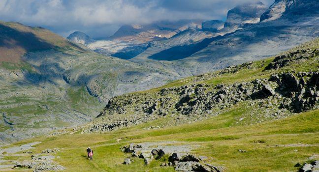
Welcome to the wildest, most unspoiled corner of the Pyrenees. The three main valleys of this national park—Ordesa, Pineta, and Añisclo—are carved out by the Ara River and its tributaries, the Arazas. They culminate in the majestic massif of Monte Perdido, which stands at 3,350 meters (11,000 feet) on the Franco-Spanish border; it's the highest of the park's three main mountains. The remote yet worthwhile valley of Las Gargantas de Escuaín is famous for its dolmen and soaring rock walls. Throughout the park, you'll find lakes, waterfalls, high mountain meadows, and forests of pine, fir, larch, beech, and poplar. Protected wildlife includes trout, boar, chamois, lammergeier, and the sarrio mountain goat (Rupicapra pyrenaica).

\n

Well-marked mountain trails lead to waterfalls, caves, and spectacular observation points. The Cola de Caballo, for example, is a five-to-six-hour round-trip route to one of those majestic waterfalls. From mid-July to mid-September and during Holy Week holidays, the town of Torla offers a shuttle service every 15 minutes to the trailhead in Pradera de Ordesa to manage overcrowded parking.

Caldera de Taburiente National Park

Fodor's Choice

What strikes you first about Caldera de Taburiente National Park is its sheer verticality, jutting over 900 meters (3,000 feet) above sea level, which feels dramatic considering that the ocean is only a couple of miles away as the crow flies. Trails here take you through dense Canarian pine forests, meadows of wildflowers, dramatic gorges, and burbling streams. All around you are even higher, jagged cliff tops whose peaks are often hidden above the cloud line. There are essentially two routes: one uphill and one downhill. The latter is far and away more enjoyable, but you'll have to hire a taxi (approximately €55; you may wish to split the fee with other hikers) at the Barranco de las Angustias (aka Parking de la Villa) to drop you at the trailhead at Mirador Los Brecitos. You then walk the scenic route from Los Brecitos back down to the taxi stand, four to seven hours depending on how pokey you are. The hike is steep with lots of uneven surfaces and not suited to all travelers. Bring plenty of water and snacks. If you visit in spring or early summer, you'll be treated to jaw-dropping indigo tajinaste flowers in bloom. Islabonitatours ( www.islabonitatours.com) is an outstanding English-speaking tour company that can make all transportation arrangements and provide knowledgeable mountain guides.

Parc Nacional d'Aigüestortes i Estany de Sant Maurici

Fodor's Choice

Get ready to marvel at some of the most arresting mountain scenery in Europe. The terrain of this national park is formed by jagged peaks, steep rock walls, and deep glacial depressions filled with crystalline water, all of which lie in the shadow of the twin peaks of Els Encantats. Until the turn of the last century, this area was one of the remotest in Europe, known only to shepherds and hunters. Its 200-some streams, lakes, and lagoons intersperse with fir and birch forests and empty into the Noguera River watercourses: the Pallaresa to the east and the Ribagorçana to the west. Rain and snow are notably frequent in all areas. The land sweeps from wildflower-blanketed meadows below 1,524 meters (5,000 feet) to rocky crests at nearly double that height. The twin Encantats measure more than 2,743 meters (9,000 feet), and the surrounding peaks of Beciberri, Peguera, Montarto, and Amitges hover between 2,651 meters (8,700 feet) and a little less than 3,048 meters (10,000 feet). The park offers an abundance of walking trails; the most popular is a day hike from east to west, starting at the village of Espot and finishing in Boí. Less time is needed to see the glacial lakes at Circ de Colomèrs, a 40-minute drive south from Baqueira.  Driving inside the park is not permitted, so most visitors leave their cars at the closest entrance and then take a taxi or shuttle, stationed at the main parking areas, to the trailhead.

Recommended Fodor's Video

Parque Natural de Monfragüe

Fodor's Choice

At the junction of the Tiétar and Tajo rivers, 20 km (12 miles) south of Plasencia on the EX208 and 60 km (37 miles) southwest of La Vera via the EX203, lies Extremadura's only national park. This rocky, mountainous wilderness is known for its diverse plant and animal life including lynx, boars, deer, foxes, black storks, imperial eagles, and the world's largest colony of black vultures, attracting bird-watchers from around the world. Bring binoculars and head for the lookout point called Salto del Gitano (Gypsy's Leap), on the EX208 just south of the Tajo River—vultures can often be spotted wheeling in the dozens at close range. The park's central visitor center and main entrance is in the village of Villareal de San Carlos.