


Got rocks? A winter visit to UtahÆs Orogenous Zones


 Jan 25th, 2022 | 11:35 AM
#23
Original Poster


Joined: Jan 2003
Posts: 21,174
Likes: 83
January 12 –
We'd hoped to hike the four mile trail to Escalante Natural Bridge before leaving the area, but changed our minds when we discovered it would involve five river crossings...just what I need on a cold January morning - wet feet and ice. Thanks, but no.
It was 35 F and sunny when we eventually left Escalante and drove the one hour to Bryce via UT 12. The drive was pretty, but not as interesting as the Torrey to Escalante portion, even with the snow.
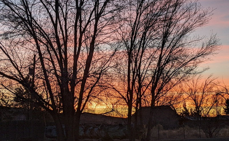
Sunrise, Escalante
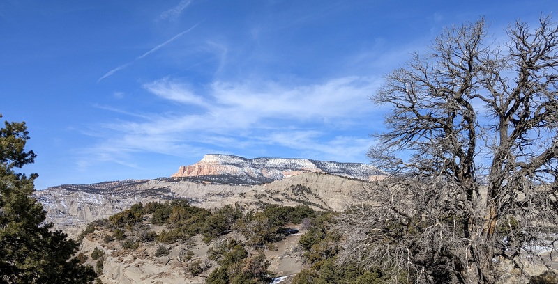
Drive from Escalante to Bryce
Drive from Escalante to Bryce
We stopped in Tropic for lunch at IDK BBQ - we the only customers - it was either really good - or we were just desperate for a break from microwave soup, dahl, and ramen noodles.
We then made the final 10 mile drive to Bryce Canyon City - which is basically a collection of hotels, a gas station or two, a handful of restaurants (most of them closed), a general store and a few shuttered tourist shops.
Surprisingly, gas was cheaper here ($3.59) than in either Tropic or Cannonville ($4.22).
After getting settled in The Best Western Grand ($269 plus 15,580 points worth $77.90 that I’d completely forgotten about – big room, quiet, breakfast buffet with hot and cold items, room was actually serviced!), checking in three hours before check-in time - we drove into Bryce Canyon National Park.
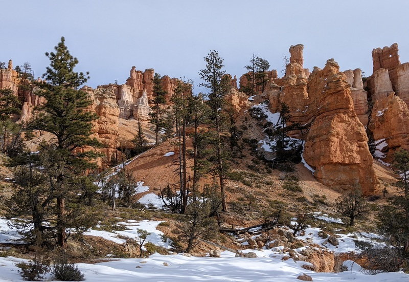
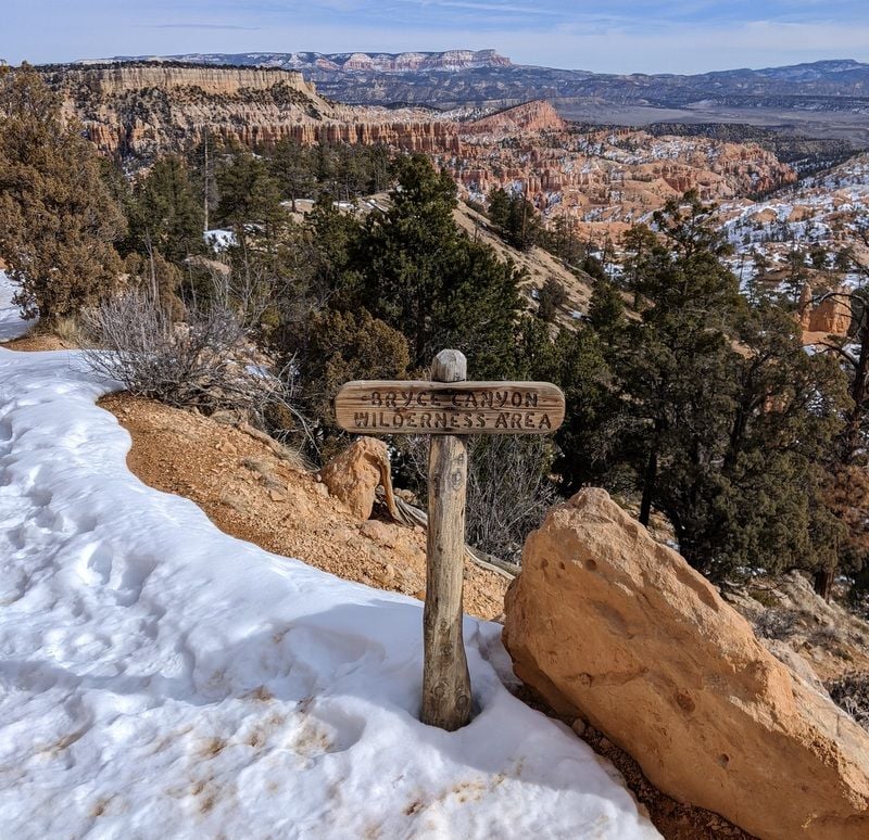
We explored the 18 mile scenic road, stopped at all the outlooks for the obligatory photos – hearing many languages and seeing license plates from as far away as British Columbia, and inadvertently stumbling upon an anti-vax conversation between a local and a couple from Germany, whom we gave a wide berth.
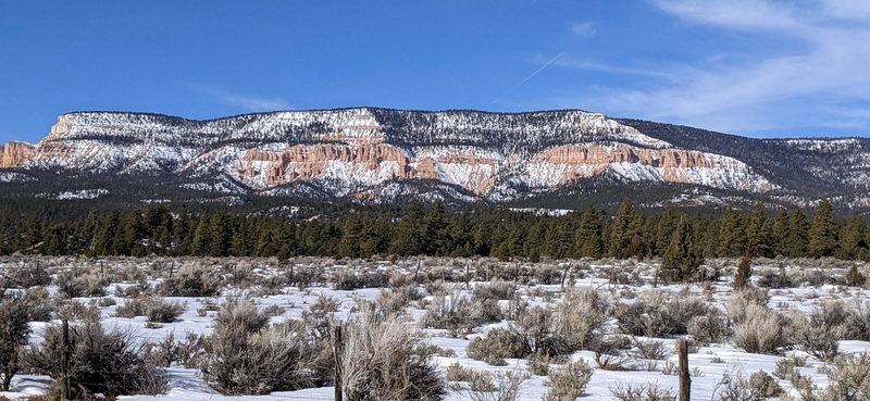
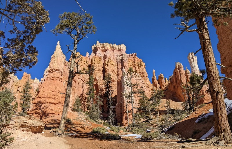
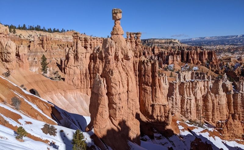
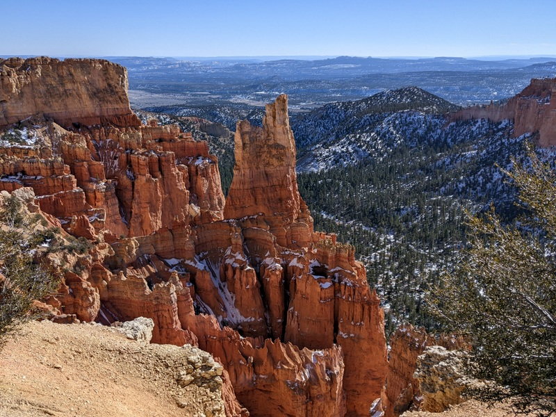
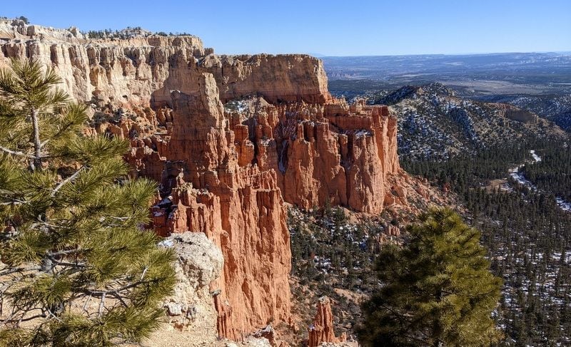
Bryce Canyon National Park
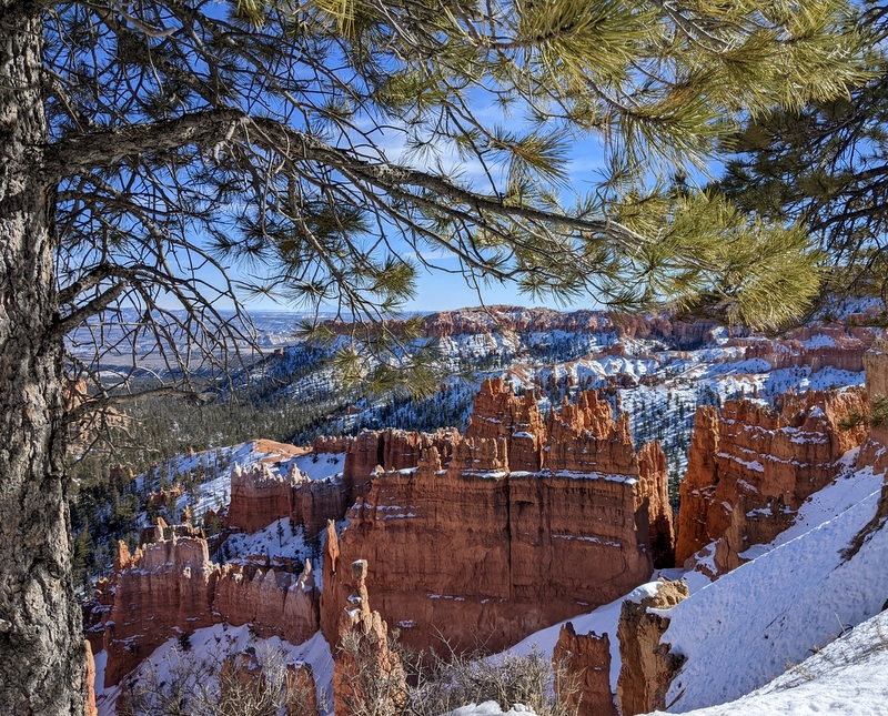
Bryce Canyon National Park
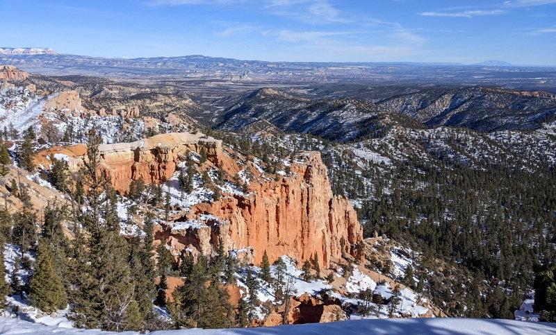
Bryce Canyon National Park
Bryce Canyon National Park

Bryce Canyon National Park
Bryce Canyon National Park
Bryce Canyon National Park
Yay!
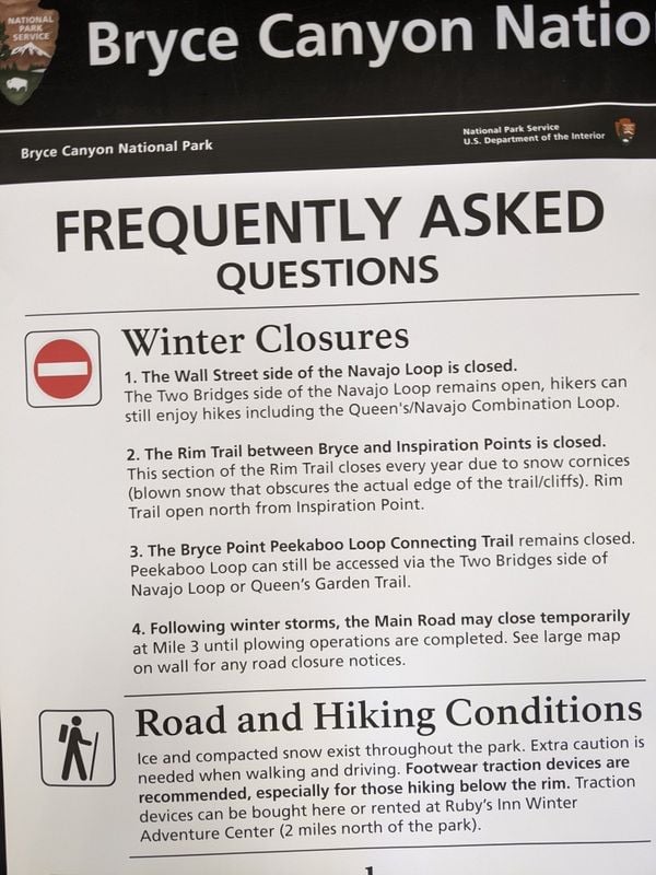
Before leaving the park for the day, we popped into the Visitor’s Center and picked the brains of a helpful park ranger who told us that until last week, the road into Bryce had been closed due to snow.
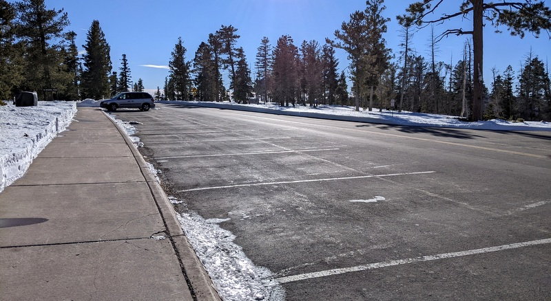
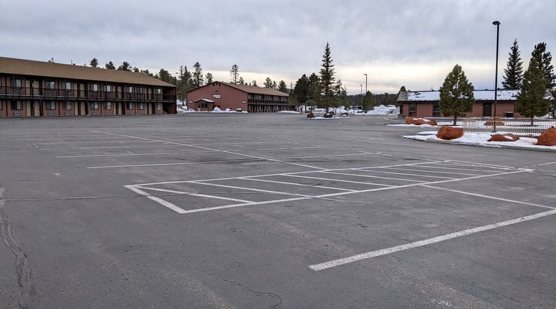
As expected, it was busier here than in Capitol Reef and Escalante, which initially put Bill off a bit - until I pointed out the empty parking lots and reminded him that Bryce gets over 1.5 million visitors a year. (Don't tell him, but Zion, which is our next stop, had 3.6 million visitors in 2020!)
It didn’t take long to learn that everything in Bryce Canyon City seems to be owned by Ruby… so who is Ruby?
From the Ruby’s Inn website:
In 1916, Reuben C. (Ruby) Syrett brought his family to the wilds of Southern Utah, establishing a ranch near the present site of Ruby's Inn. A few weeks after his arrival, another nearby rancher told Ruby of the canyon called Bryce. Ruby and his family made a Sunday visit to the canyon rim. They were so impressed by what they saw that they not only took full advantage to tell people of the canyon's beauties, but they also became hosts to its visitors. By 1919 they had obtained permission from the state to build a lodge, the "Tourist Rest", near the brink of the canyon.
In 1923, when Bryce Canyon became a National Monument, Ruby moved his "Tourist Rest", to the location of his ranch and named it Ruby's Inn. The Post Office established services at the inn and still serves the area throughout the year. Ruby's reputation grew as the National Monument grew to a National Park, and soon Ruby's Inn became a large business operation. What started with tent houses and a place to serve meals, paved the way for the modern facilities which today serve the tourists at Bryce Canyon, providing all the traveler needs to make a stay in the Bryce Canyon area a trip to remember. Enthusiasm and love for the Bryce area carried over to Ruby's son Carl. Today the same western hospitality and friendly service is carried on by Carl's children and grandchildren, who cheerfully welcome you to Ruby's Inn.
To be continued…
We'd hoped to hike the four mile trail to Escalante Natural Bridge before leaving the area, but changed our minds when we discovered it would involve five river crossings...just what I need on a cold January morning - wet feet and ice. Thanks, but no.
It was 35 F and sunny when we eventually left Escalante and drove the one hour to Bryce via UT 12. The drive was pretty, but not as interesting as the Torrey to Escalante portion, even with the snow.
Sunrise, Escalante
Drive from Escalante to Bryce
Drive from Escalante to Bryce
We stopped in Tropic for lunch at IDK BBQ - we the only customers - it was either really good - or we were just desperate for a break from microwave soup, dahl, and ramen noodles.
We then made the final 10 mile drive to Bryce Canyon City - which is basically a collection of hotels, a gas station or two, a handful of restaurants (most of them closed), a general store and a few shuttered tourist shops.
Surprisingly, gas was cheaper here ($3.59) than in either Tropic or Cannonville ($4.22).
After getting settled in The Best Western Grand ($269 plus 15,580 points worth $77.90 that I’d completely forgotten about – big room, quiet, breakfast buffet with hot and cold items, room was actually serviced!), checking in three hours before check-in time - we drove into Bryce Canyon National Park.
We explored the 18 mile scenic road, stopped at all the outlooks for the obligatory photos – hearing many languages and seeing license plates from as far away as British Columbia, and inadvertently stumbling upon an anti-vax conversation between a local and a couple from Germany, whom we gave a wide berth.
Bryce Canyon National Park
Bryce Canyon National Park
Bryce Canyon National Park
Bryce Canyon National Park
Bryce Canyon National Park
Bryce Canyon National Park
Bryce Canyon National Park
Yay!
Before leaving the park for the day, we popped into the Visitor’s Center and picked the brains of a helpful park ranger who told us that until last week, the road into Bryce had been closed due to snow.
As expected, it was busier here than in Capitol Reef and Escalante, which initially put Bill off a bit - until I pointed out the empty parking lots and reminded him that Bryce gets over 1.5 million visitors a year. (Don't tell him, but Zion, which is our next stop, had 3.6 million visitors in 2020!)
It didn’t take long to learn that everything in Bryce Canyon City seems to be owned by Ruby… so who is Ruby?
From the Ruby’s Inn website:
In 1916, Reuben C. (Ruby) Syrett brought his family to the wilds of Southern Utah, establishing a ranch near the present site of Ruby's Inn. A few weeks after his arrival, another nearby rancher told Ruby of the canyon called Bryce. Ruby and his family made a Sunday visit to the canyon rim. They were so impressed by what they saw that they not only took full advantage to tell people of the canyon's beauties, but they also became hosts to its visitors. By 1919 they had obtained permission from the state to build a lodge, the "Tourist Rest", near the brink of the canyon.
In 1923, when Bryce Canyon became a National Monument, Ruby moved his "Tourist Rest", to the location of his ranch and named it Ruby's Inn. The Post Office established services at the inn and still serves the area throughout the year. Ruby's reputation grew as the National Monument grew to a National Park, and soon Ruby's Inn became a large business operation. What started with tent houses and a place to serve meals, paved the way for the modern facilities which today serve the tourists at Bryce Canyon, providing all the traveler needs to make a stay in the Bryce Canyon area a trip to remember. Enthusiasm and love for the Bryce area carried over to Ruby's son Carl. Today the same western hospitality and friendly service is carried on by Carl's children and grandchildren, who cheerfully welcome you to Ruby's Inn.
To be continued…
Last edited by Melnq8; Jan 25th, 2022 at 11:43 AM.


 Jan 27th, 2022 | 07:14 AM
#34
Original Poster
Joined: Jan 2003
Posts: 21,174
Likes: 83
January 13 –
The hotel felt busy; hotel staff were visible and a flurry of activity. The breakfast room this morning had 6-8 groups; not exactly heaving, but busy compared to Capitol Reef and Escalante.
We’d noticed several large carpet cleaners stored in various corners; we were about to understand why.
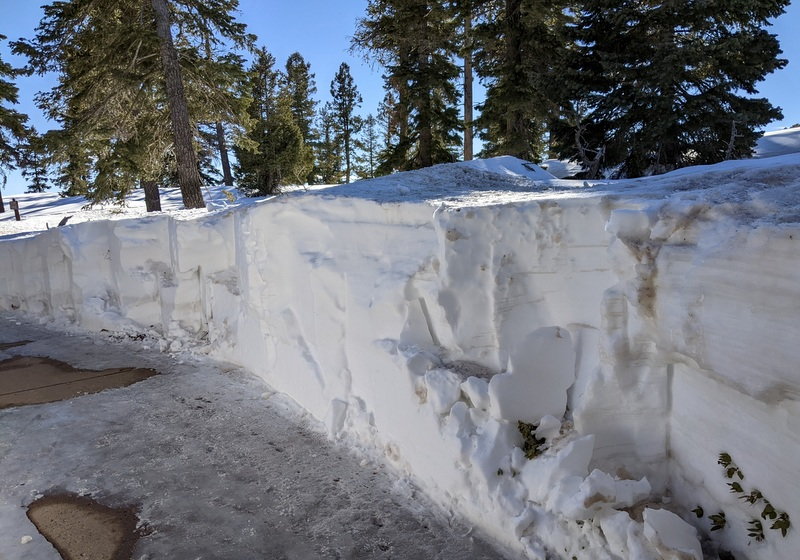
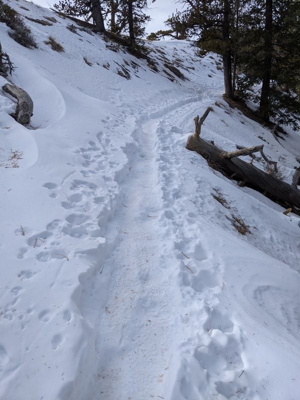
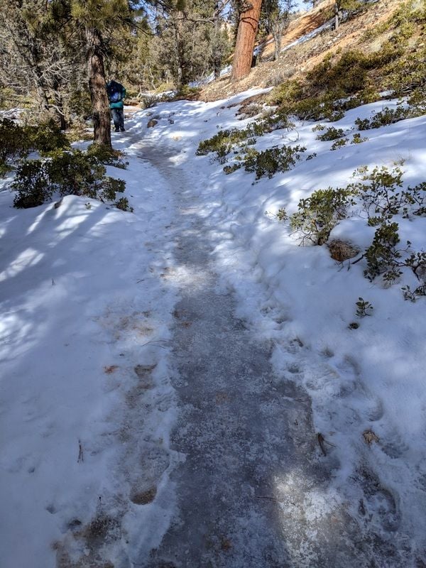
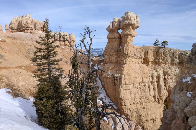
It was 28 F when we set out to hike the 3.5 mile trail to Tower Bridge, which began at Sunrise Point. This is an out and back trail with an elevation change of 802 feet – downhill to the bridge and then back uphill to climb out of the canyon.
Winter hiking isn’t without its challenges and today’s were numerous; the packed snow was welcome, but the solid ice, deep drifts and gumbo soil were a bit of a nightmare. I managed to take a spill despite my traction cleats and we didn’t think we’d ever get the gumbo off our boots. That stuff is nasty; it clings to your shoes like glue, weighs your feet down and feels like you’re walking in quicksand. We were both well covered in mud by the time we finished the hike 2-3/4 hours later. We saw only one other person on the trail; also covered in mud. All those carpet cleaners suddenly made sense.
Had we known how anticlimactic the bridge would be and how much mud we'd encounter getting there, we'd probably have bailed early.
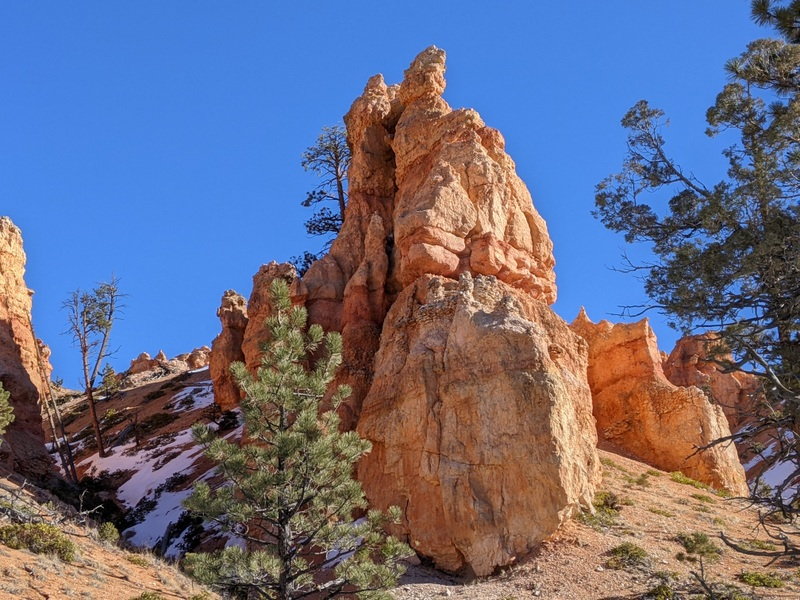
Tower Bridge Trail
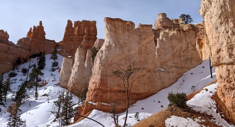
Tower Bridge Trail
Tower Bridge Trail
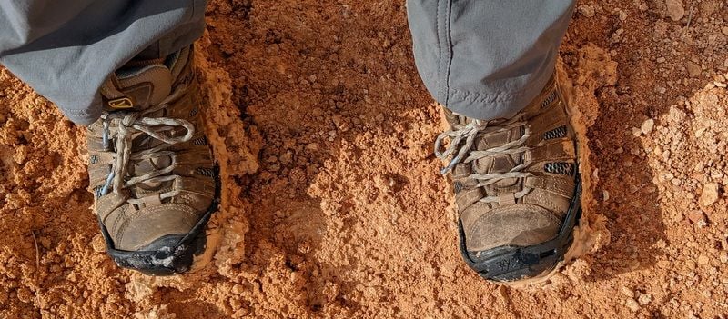
Gumbo
Tower Bridge Trail
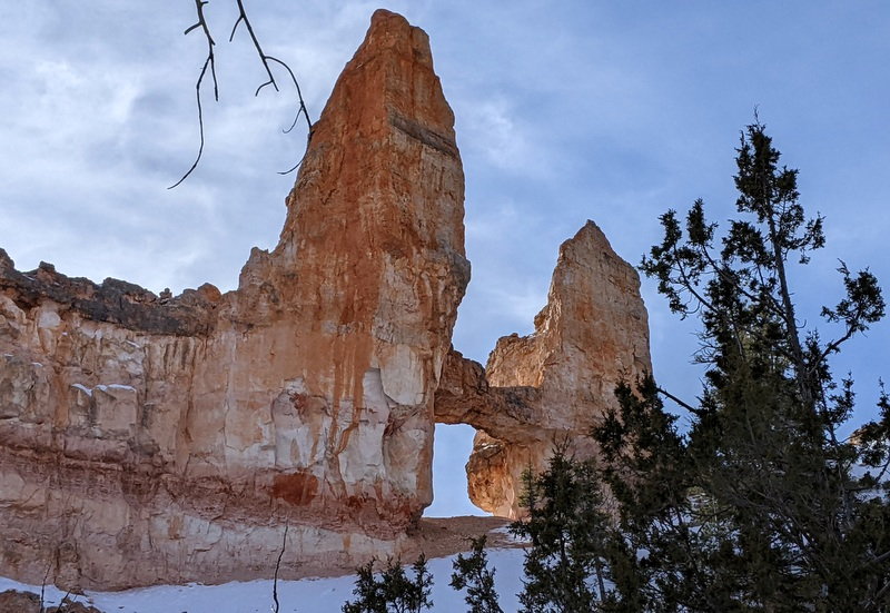
And there is is, Tower Bridge
Tower Bridge Trail
Gluttons for punishment, we decided to take a stab at the Rim Trail as well, walking just over two miles between Sunrise Point and Fairyland Point before we got tired of slipping around in the slush and called it a day. We only saw two people on this trail, Australians who told us we were the first people they’d seen since they began their hike three hours before.
Rim Trail
Rim Trail
Rim Trail
Rim Trail
The park seemed much quieter today than yesterday and was downright peaceful on the trails. And the views were tremendous.
We drove back to Tropic for an encore early dinner at IDK BBQ; still good, this time there were three other customers…and a sad looking stray cat that I left a few bits of chicken for; a worker telling me the cat probably ate better than he did. This was the fourth stray cat we’d seen hanging outside of a business in the past week.
Then it was back to the hotel and a deserted parking lot.
To be continued...
The hotel felt busy; hotel staff were visible and a flurry of activity. The breakfast room this morning had 6-8 groups; not exactly heaving, but busy compared to Capitol Reef and Escalante.
We’d noticed several large carpet cleaners stored in various corners; we were about to understand why.
It was 28 F when we set out to hike the 3.5 mile trail to Tower Bridge, which began at Sunrise Point. This is an out and back trail with an elevation change of 802 feet – downhill to the bridge and then back uphill to climb out of the canyon.
Winter hiking isn’t without its challenges and today’s were numerous; the packed snow was welcome, but the solid ice, deep drifts and gumbo soil were a bit of a nightmare. I managed to take a spill despite my traction cleats and we didn’t think we’d ever get the gumbo off our boots. That stuff is nasty; it clings to your shoes like glue, weighs your feet down and feels like you’re walking in quicksand. We were both well covered in mud by the time we finished the hike 2-3/4 hours later. We saw only one other person on the trail; also covered in mud. All those carpet cleaners suddenly made sense.
Had we known how anticlimactic the bridge would be and how much mud we'd encounter getting there, we'd probably have bailed early.
Tower Bridge Trail
Tower Bridge Trail
Tower Bridge Trail
Gumbo
Tower Bridge Trail
And there is is, Tower Bridge
Tower Bridge Trail
Gluttons for punishment, we decided to take a stab at the Rim Trail as well, walking just over two miles between Sunrise Point and Fairyland Point before we got tired of slipping around in the slush and called it a day. We only saw two people on this trail, Australians who told us we were the first people they’d seen since they began their hike three hours before.
Rim Trail
Rim Trail
Rim Trail
Rim Trail
The park seemed much quieter today than yesterday and was downright peaceful on the trails. And the views were tremendous.
We drove back to Tropic for an encore early dinner at IDK BBQ; still good, this time there were three other customers…and a sad looking stray cat that I left a few bits of chicken for; a worker telling me the cat probably ate better than he did. This was the fourth stray cat we’d seen hanging outside of a business in the past week.
Then it was back to the hotel and a deserted parking lot.
To be continued...
Jan 27th, 2022 | 07:57 AM
#35
Original Poster
Joined: Jan 2003
Posts: 21,174
Likes: 83
January 14 –
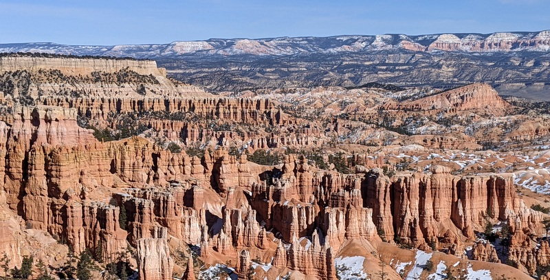
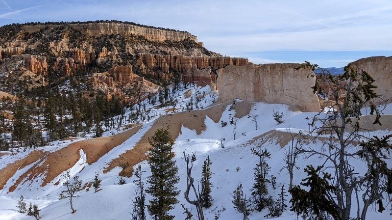
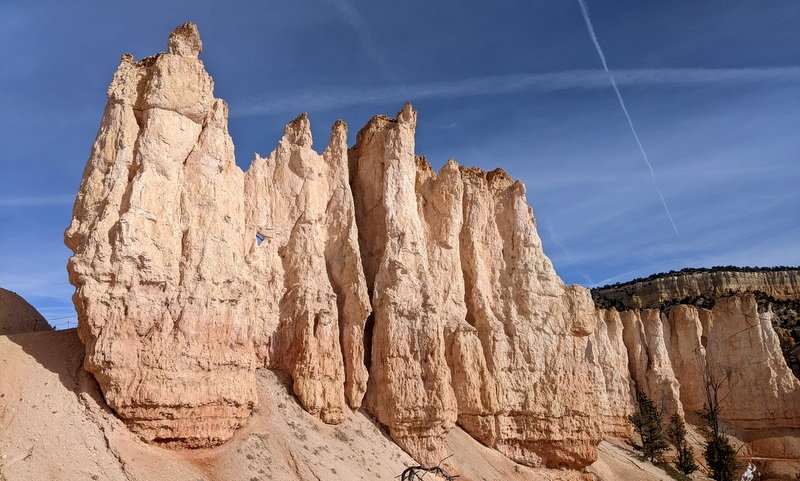
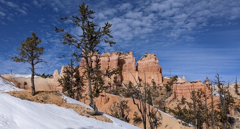
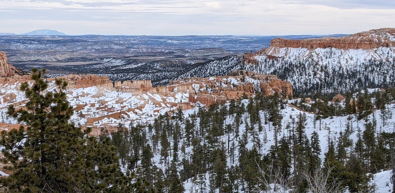
It was 28 F again, but also very windy when we left the car at Sunset Point, walked to Sunrise Point and followed the Queen's Garden trail into hoodoo nirvana Bryce Amphitheater, understanding immediately why this is the most popular hike in Bryce Canyon - it’s gorgeous.
Once at Queen's Garden, we continued on to the Navajo Trail via Two Bridges, the winter option. This trail has an elevation gain of 600 feet, all of it coming at the end, as one climbs back up the canyon.
The National Park service recommends walking this trail in a clockwise direction - which we did – but only two of the other 40 odd people we saw on the trail seemed to have gotten the memo.
And they paid the price; those 600 feet of switchbacks were steep and very icy; making the descent damn dangerous; especially for the fools wearing sneakers and other inappropriate footwear. We even saw a kid wearing slip on sneakers with no socks – hello?
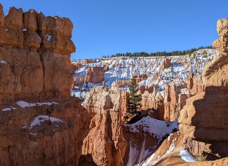
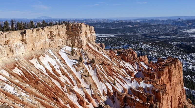
Queen's Garden/Navajo Loop
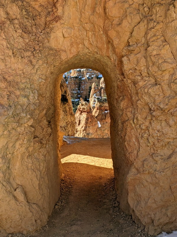
Queen's Garden/Navajo Loop
Queen's Garden/Navajo Loop
Queen's Garden/Navajo Loop
Queen's Garden/Navajo Loop

Queen's Garden/Navajo Loop
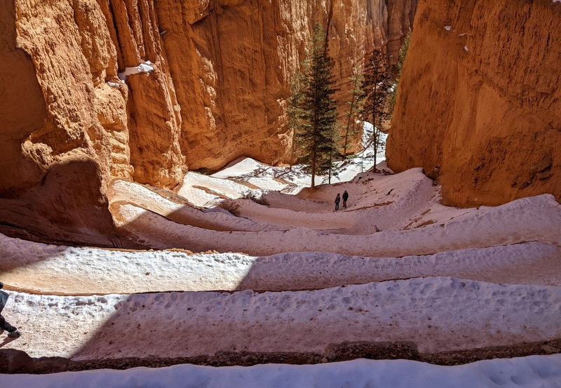
Queen's Garden/Navajo Loop
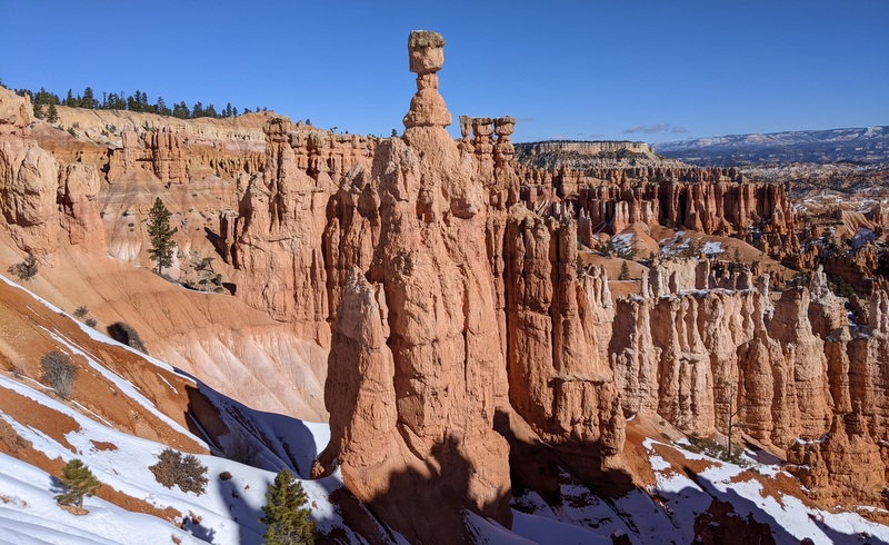
Queen's Garden/Navajo Loop
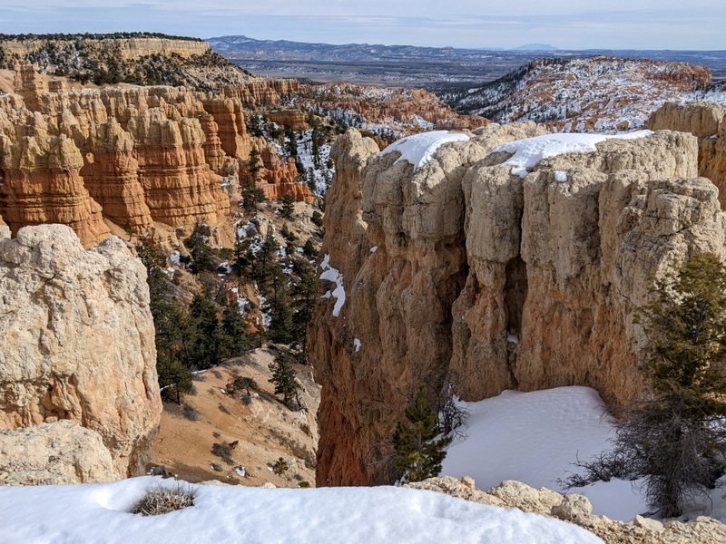
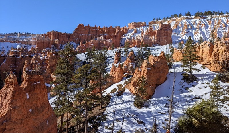
Some three miles later we were back at the top, where we decided to hike the Rim Trail to Inspiration Point and then back to Sunset Point. It was quieter up here, we only saw seven people, and of course some of them were wearing sneakers and sliding around all over the place. Pretty scary considering the trail is mere feet from the canyon’s edge.
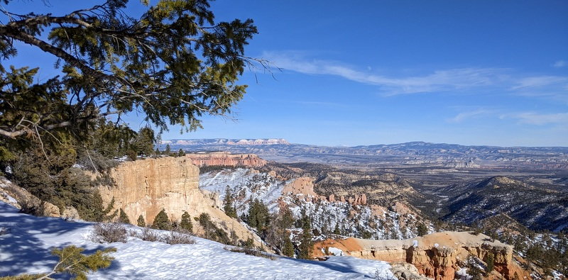
Rim Trail to Inspiration Point
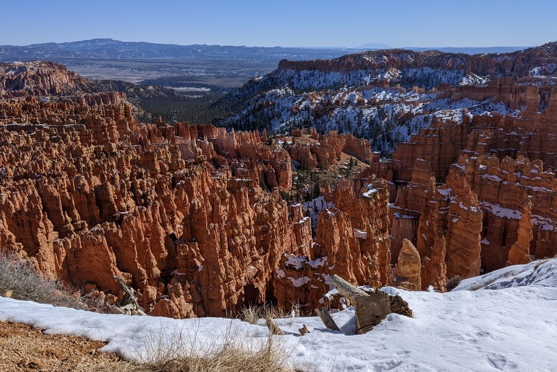
Rim Trail to Inspiration Point
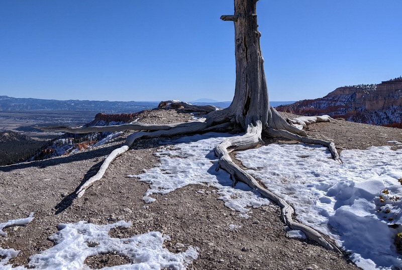
Rim Trail to Inspiration Point - check out those roots
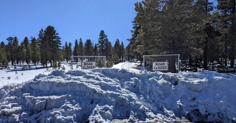
After a cold picnic at Sunset Point, we drove to the overlooks we’d missed the other day, and then decided to explore Paria View. The road is closed in winter, presumably to give people a place to snowshoe. We walked the mile to the overlook - which was gorgeous - and completely devoid of people.
Road to Paria View
Paria View
Paria View
We then drove to a parking area 2/10 of a mile from the road to Fairyland Point, also closed in winter. We trudged through some pretty deep snow, eventually locating the closed road, which was groomed for cross country skiers. We then followed it a few miles to the overlook, which we had entirely to ourselves, then backtracked to the car.
All in all we logged some eight miles. A hot shower never felt so good.
To be continued…
It was 28 F again, but also very windy when we left the car at Sunset Point, walked to Sunrise Point and followed the Queen's Garden trail into hoodoo nirvana Bryce Amphitheater, understanding immediately why this is the most popular hike in Bryce Canyon - it’s gorgeous.
Once at Queen's Garden, we continued on to the Navajo Trail via Two Bridges, the winter option. This trail has an elevation gain of 600 feet, all of it coming at the end, as one climbs back up the canyon.
The National Park service recommends walking this trail in a clockwise direction - which we did – but only two of the other 40 odd people we saw on the trail seemed to have gotten the memo.
And they paid the price; those 600 feet of switchbacks were steep and very icy; making the descent damn dangerous; especially for the fools wearing sneakers and other inappropriate footwear. We even saw a kid wearing slip on sneakers with no socks – hello?
Queen's Garden/Navajo Loop
Queen's Garden/Navajo Loop
Queen's Garden/Navajo Loop
Queen's Garden/Navajo Loop
Queen's Garden/Navajo Loop
Queen's Garden/Navajo Loop
Queen's Garden/Navajo Loop
Queen's Garden/Navajo Loop
Some three miles later we were back at the top, where we decided to hike the Rim Trail to Inspiration Point and then back to Sunset Point. It was quieter up here, we only saw seven people, and of course some of them were wearing sneakers and sliding around all over the place. Pretty scary considering the trail is mere feet from the canyon’s edge.
Rim Trail to Inspiration Point
Rim Trail to Inspiration Point
Rim Trail to Inspiration Point - check out those roots
After a cold picnic at Sunset Point, we drove to the overlooks we’d missed the other day, and then decided to explore Paria View. The road is closed in winter, presumably to give people a place to snowshoe. We walked the mile to the overlook - which was gorgeous - and completely devoid of people.
Road to Paria View
Paria View
Paria View
We then drove to a parking area 2/10 of a mile from the road to Fairyland Point, also closed in winter. We trudged through some pretty deep snow, eventually locating the closed road, which was groomed for cross country skiers. We then followed it a few miles to the overlook, which we had entirely to ourselves, then backtracked to the car.
All in all we logged some eight miles. A hot shower never felt so good.
To be continued…
Jan 27th, 2022 | 08:58 AM
#38
Joined: Jan 2003
Posts: 13,427
Likes: 0
How deep was the snow at Paria View and Fairyland Point? I'm hoping it snows again before we leave. We were supposed to go for the winter festival last year but canceled due to lack of snow. Trying again for this year but it's not looking very promising.
Jan 27th, 2022 | 09:22 AM
#39
Original Poster
Joined: Jan 2003
Posts: 21,174
Likes: 83
January 15 –
A peek out the hotel window revealed a thick layer of frost on every surface; 12 degrees and 73% humidity. In other words, damn cold.
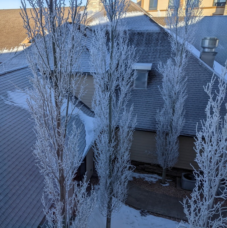
View from our hotel window, Bryce
Bryce
We left our digs in Bryce Canyon City and headed west on UT 12, passing through Red Canyon, and eventually joining 89 south, Utahn speeders blowing our doors off. The landscape was rather non-descript after the past week of stunning views.
We passed through one sad derelict town after another; the seemingly abandoned Hatch, the mud-encrusted car graveyard of Glendale, its light posts still sporting forlorn Christmas decorations, the ugly town of Orderville - where I counted three rock shops - and the junky Mt Carmel, where it looked like its population of 72 collectively owned about 400 cars.
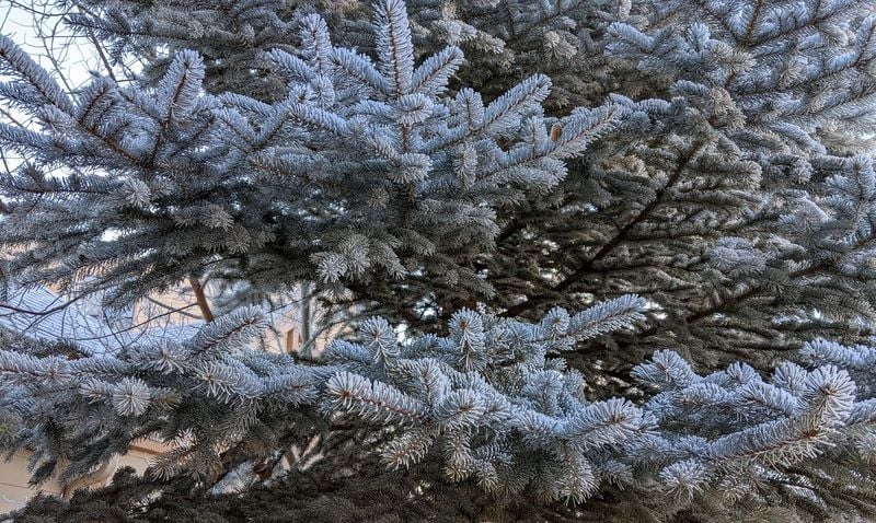
The low fog didn’t enhance our surroundings; it felt as if we were driving through a cloud, sporadic snippets of sun trying to break through. The frost was now only on the north side of the trees; creating an interesting effect.
We eventually joined 9 west; the scenery becoming prettier and prettier. We passed a large herd of bison and were soon entering Zion National Park via the deserted east entrance. We passed through the 1.1 mile long Zion-Mt Carmel Tunnel, surprised that it had no lights, and were soon simultaneously wowed by the scenery and annoyed by the sheer number of people.
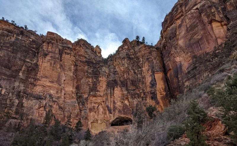
First glimpse, Zion National Park
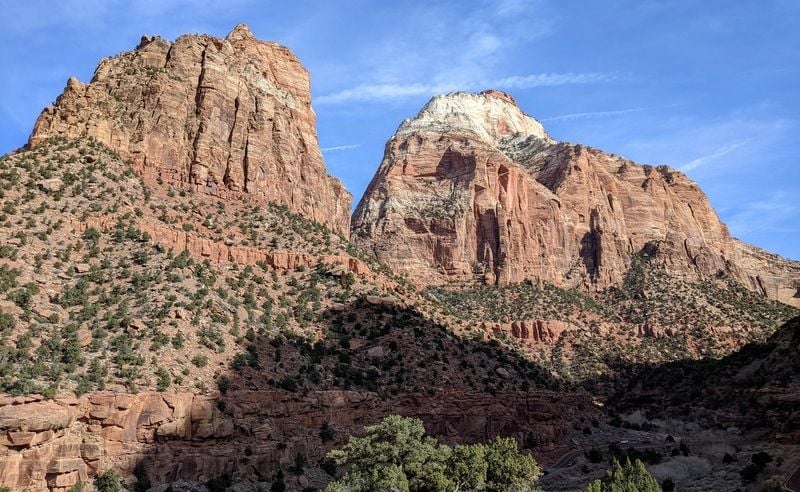
Zion National Park
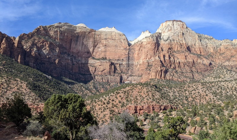
Zion National Park
The Zion Canyon Scenic Drive was closed when we passed by; we later learned from Visitor’s Center staff that there are only 450 parking spaces available and they're usually full by 10 am - EVEN IN JANUARY.
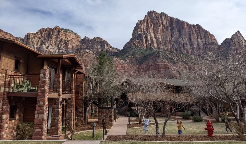
We tried to check in at Cable Mountain Lodge, but our luck checking in early had run out. We were given key cards that would give us a 20% discount at the nearby Zion Canyon Brew Pub while we waited for check-in time to roll around.
We asked the guy in reception if the massive queue at the south entrance to Zion – which we could see from the lodge windows - was normal for January. He said lodge staff had been surprised as well, that the past week had been dead quiet, but it was probably due to the half marathon in St. George that day. He also warned us that Monday would be busy too, as it was MLK day and park entry was free. I had no idea MLK weekend was a busy travel holiday. How did I miss this?
We headed to the pub, moody and wondering if we should bail early on Zion, drowning our sorrows in some artery clogging, not-particularly-good bar snacks.
From our riverside seats we watched endless cars queue up to enter the park - so many that we were afraid to leave and go to Springdale, knowing that we'd have to join the queue just to get back to our hotel. This went on until almost 4 pm.
We eventually drove into Springdale to check things out and to pick up some libations at the Switchback liquor store. I was surprised at the size of Springdale. And happy I’d changed our booking from the Majestic View Lodge (which looked to be furthest from Zion’s south entrance) to Cable Mountain Lodge.
View from our room
To be continued…
A peek out the hotel window revealed a thick layer of frost on every surface; 12 degrees and 73% humidity. In other words, damn cold.
View from our hotel window, Bryce
Bryce
We left our digs in Bryce Canyon City and headed west on UT 12, passing through Red Canyon, and eventually joining 89 south, Utahn speeders blowing our doors off. The landscape was rather non-descript after the past week of stunning views.
We passed through one sad derelict town after another; the seemingly abandoned Hatch, the mud-encrusted car graveyard of Glendale, its light posts still sporting forlorn Christmas decorations, the ugly town of Orderville - where I counted three rock shops - and the junky Mt Carmel, where it looked like its population of 72 collectively owned about 400 cars.
The low fog didn’t enhance our surroundings; it felt as if we were driving through a cloud, sporadic snippets of sun trying to break through. The frost was now only on the north side of the trees; creating an interesting effect.
We eventually joined 9 west; the scenery becoming prettier and prettier. We passed a large herd of bison and were soon entering Zion National Park via the deserted east entrance. We passed through the 1.1 mile long Zion-Mt Carmel Tunnel, surprised that it had no lights, and were soon simultaneously wowed by the scenery and annoyed by the sheer number of people.
First glimpse, Zion National Park
Zion National Park
Zion National Park
The Zion Canyon Scenic Drive was closed when we passed by; we later learned from Visitor’s Center staff that there are only 450 parking spaces available and they're usually full by 10 am - EVEN IN JANUARY.
We tried to check in at Cable Mountain Lodge, but our luck checking in early had run out. We were given key cards that would give us a 20% discount at the nearby Zion Canyon Brew Pub while we waited for check-in time to roll around.
We asked the guy in reception if the massive queue at the south entrance to Zion – which we could see from the lodge windows - was normal for January. He said lodge staff had been surprised as well, that the past week had been dead quiet, but it was probably due to the half marathon in St. George that day. He also warned us that Monday would be busy too, as it was MLK day and park entry was free. I had no idea MLK weekend was a busy travel holiday. How did I miss this?
We headed to the pub, moody and wondering if we should bail early on Zion, drowning our sorrows in some artery clogging, not-particularly-good bar snacks.
From our riverside seats we watched endless cars queue up to enter the park - so many that we were afraid to leave and go to Springdale, knowing that we'd have to join the queue just to get back to our hotel. This went on until almost 4 pm.
We eventually drove into Springdale to check things out and to pick up some libations at the Switchback liquor store. I was surprised at the size of Springdale. And happy I’d changed our booking from the Majestic View Lodge (which looked to be furthest from Zion’s south entrance) to Cable Mountain Lodge.
View from our room
To be continued…
Jan 27th, 2022 | 09:32 AM
#40
Original Poster
Joined: Jan 2003
Posts: 21,174
Likes: 83
Patty -
The snow was about 18" deep at both, but the road to Paria View was easy to navigate with hiking boots - once getting around the gate to the road - as it had been packed down by snowshoers. Same for Fairyland Point, where the road was groomed for cross country skiers. Getting to the road to Fairyland Point involved a bit of deep cross country trudging though as we had to park some distance from the road - no parking in the immediate vicinity.
Why is your trip not looking good?

