52 Best Sights in USA

Background Illustration for Sights

We've compiled the best of the best in USA - browse our top choices for the top things to see or do during your stay.

Denali

Fodor's Choice
A Photo of Mt. McKinley in Denali National Park, Alaska.
Lowthian | Dreamstime.com

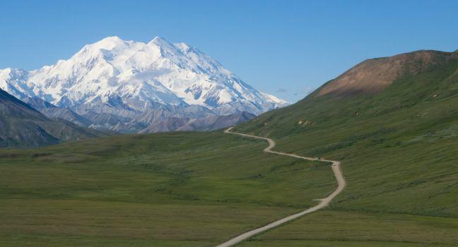
In the heart of mainland Alaska, within 6-million-acre Denali National Park and Preserve, the continent's most majestic peak rises into the heavens. Formerly known as Mt. McKinley, this 20,310-foot massif of ice, snow, and rock has been renamed to honor its Alaska Native name, Denali, or "the High One." Some simply call it "the Mountain." One thing is certain: it's a giant among giants, and the most dominant feature in a land of extremes and superlatives. Those who have walked Denali's slopes know it to be a wild, desolate place. As the highest peak in North America, Denali is a target of mountaineers who aspire to ascend the "seven summits"—the tallest mountains of each of the seven continents. A foreboding and mysterious place, it was terra incognita—unclimbed and unknown to most people—as recently as the late 1890s. Among Athabascan tribes, however, the mountain was a revered landmark; many generations regarded it as a holy place and a point of reference. The mountain's vertical rise is the highest in the world. This means that at 18,000 feet over the lowlands (which are some 2,000 feet above sea level), Denali's vertical rise is even greater than that of Mt. Everest at 29,035-feet (which sits 12,000 feet above the Tibetan plateau, some 17,000 feet above sea level). Denali's awesome height and its subarctic location make it one of the coldest mountains on Earth, if not the coldest. Primarily made of granite, Denali undergoes continual shifting and uplift thanks to plate tectonics (the Pacific Plate pushing against the North American Plate); it grows about 1 millimeter per year.

Denali National Park, AK, USA

Something incorrect in this review?

Grandfather Mountain

Fodor's Choice
Grandfather Mountain near Linville, North Carolina, is known for its mile-high swinging bridge, the highest in America.
Cvandyke / Shutterstock

Soaring to almost 6,000 feet, Grandfather Mountain is famous for its Mile-High Swinging Bridge, a 228-foot-long footbridge that sways over a 1,000-foot drop into the Linville Valley. There are 13 miles of hiking trails and some 100 picnic tables. Part of the area is a state park with free admission, and part is private land—including the swinging bridge, a museum, a small zoo, and picnic areas—with a $20 admission fee.

Bear Butte State Park

Fodor's Choice
On the plains outside Sturgis, there's a mountain where it seemingly should not be: Bear Butte rises more than 1,200 feet above its surroundings (and 4,400 feet above sea level). It formed millions of years ago when lava pushed up from underground but never erupted. The Lakota named the resulting laccolith "Mato Paha"--translated as Bear Butte--because from some vantage points, it looks like a bear resting on its side. Today the site is a state park with a challengingly vertical, 1.85-mile trail to the summit, where the panoramic views are incredible. The butte is also a sacred site in the traditional religions of many Native Americans, whose cloth prayer-ties adorn tree branches along the hiking trail.

Recommended Fodor's Video

Brasstown Bald

Fodor's Choice

In the Chattahoochee National Forest, Brasstown Bald reaches 4,784 feet, the highest point in Georgia. Below the bald is Georgia's only cloud forest, an area of lichen-covered trees often kept wet by clouds and fog. From the observation platform at the top of the bald on a clear day you can see Georgia, North Carolina, South Carolina, and Tennessee. A paved but steep foot trail leads from the parking lot (where there are restrooms and a picnic area) to the visitor center, which has exhibits and interpretative programs. You also can ride a bus to the visitor center.

2941 Rte. 180 Spur, Hiawassee, GA, 30546, USA
706-896–2556
Sight Details
$5
Call ahead for winter closings

Something incorrect in this review?

Cadillac Mountain

Fodor's Choice

One of Acadia’s premier attractions, 1,530-foot Cadillac Mountain is the Eastern Seaboard's tallest mountain. Stunning panoramic views sweep across bays, islands, and mountains on and off Mount Desert Island. You can see Bar Harbor below on the northeast side and Eagle Lake to the west. Low-lying vegetation like pitch pine and wild blueberry plants accent granite slabs in the "subalpine-like" environment. There’s a paved summit loop trail and several hiking trails up Cadillac, named for a Frenchman who explored here in the late 1600s and later founded Detroit. From mid-May–mid-October, a vehicle reservation (done through  www.recreation.gov) is needed to drive to the summit. Sunrise slots are in high demand, as this is one of the first places in the country to experience first light. It's also the perfect spot to watch the sunset or stargaze. Bar Harbor’s light ordinance helps with the latter, but keep in mind that the access road is only open 24/7 in early spring and late fall.

Cadillac Summit Rd., Acadia National Park, ME, USA
207-288–3338
Sight Details
$6 per car (in addition to park entrance fee) via www.recreation.gov from mid-May–mid-Oct.
Access road closes at 9 pm from mid-May–mid-Oct., closed Dec.–mid-Apr.

Something incorrect in this review?

Camelback Mountain

Fodor's Choice

Named for its resemblance to a camel's hump, Phoenix's most popular landmark is also one of its most popular hiking destinations. Its two trails, Echo Canyon Trail and Cholla Trail, are both difficult to climb but lead to stunning panoramic views of the Valley. Even if you don't hike, you can still spot the towering peak from many restaurants and hotels in the Camelback Corridor and Paradise Valley neighborhoods. The mountain is a 15-minute drive from Downtown Phoenix. Dogs are not allowed on the trails. For more information on hiking, see Activities.

Chisos Basin

Fodor's Choice

Panoramic vistas, a restaurant with an up-close view of jagged mountain peaks, and glimpses of the Colima warbler (which summers in Big Bend) await in the forested Chisos Basin. The spiritual heart of Big Bend, at an elevation of 5,400 feet, it's ringed by taller peaks and has a lodge, a campground, a grocery store, an amphitheater, a visitor center, and access to some of the park's best hiking trails. Winter sometimes brings snow, but in summer this is where you can find relief from the desert heat below. The entire basin is closed due to construction until mid-2027.

Big Bend National Park, TX, 79834, USA

Something incorrect in this review?

McKittrick Canyon Contact Station

Fodor's Choice

Poster-size illustrations on a shaded, outdoor patio of this intermittently staffed ranger station tell the geological story of the Guadalupe Mountains, believed to have been carved from an ancient sea. You can also hear the recorded memoirs of oilman Wallace Pratt, who donated his ranch and surrounding area to the federal government for preservation. Nearby trailheads access a 1-mile nature loop and lengthier hikes.

Mt. Charleston

Outskirts Fodor's Choice

Sin City's refuge for hikers, naturalists, skiers, campers, and just about anyone who wants to escape the desert valley for the forest, Mt. Charleston is the highest peak in Clark County, and it offers year-round outdoor recreation. It's surrounded by the Spring Mountains National Recreation Area in the Humboldt-Toiyabe National Forest. Trails include a difficult hike to Mt. Charleston peak, the range's high point. Easier trails lead to seasonal waterfalls or rare, dripping springs where dainty columbine and stunted aspens spill down ravines and hummingbirds zoom. Or they might lead onto high, dry ridges where ancient bristlecone trees have become twisted and burnished with age.

Mt. Kearsarge

Fodor's Choice

There are two main ways to access this dramatic 2,937-foot granite peak east of Lake Sunapee. Approach it through Winslow State Park, which is closer to New London, by driving to the picnic area and hiking a 1.8-mile loop trail to the top. Or, more popularly, drive the 3½-mile scenic auto route through Rollins State Park, which snakes up the mountain's southern slope and leads to a ½-mile summit trail. However you get there, the views from the top are astounding. The park road at Rollins State Park closes at 5 pm nightly and from mid-November to late May, but from Winslow State Park you can hike Mt. Kearsarge any time of day or night, year-round. Rollins State Park is accessed from the cute Colonial village of Warner, which is worth a quick stroll.

Mt. Tamalpais State Park

Fodor's Choice

The view of Mt. Tamalpais from all around the bay can be a beauty, but that’s nothing compared to the views from the mountain, which take in San Francisco, the East Bay, the coast, and beyond. Although the summit of Mt. Tamalpais is only 2,571 feet high, the mountain rises practically from sea level, dominating the topography of Marin County. For years the 6,300-acre park has been a favorite destination for hikers, with more than 200 miles of trails when combined with surrounding public open space. The park's major thoroughfare, Panoramic Highway, snakes its way up from U.S. 101 to the Pantoll Ranger Station and down to Stinson Beach. Parking is free along the roadside, but there's an $8 fee at the ranger station (credit cards are only accepted when the station is open) and additional charges for walk-in campsites and group use.

The Mountain Theater, also known as the Cushing Memorial Amphitheatre, is a natural 4,0000-seat amphitheater that has showcased summer Mountain Plays since 1913. The Rock Spring Trail starts at the Mountain Theater and gently climbs for 1½ miles to the West Point Inn, where you can relax at picnic tables before forging ahead via Old Railroad Grade Fire Road and the Upper Fern Creek Trail to Mt. Tam's East Peak.

From the Pantoll Ranger Station, the precipitous Steep Ravine Trail brings you past stands of coastal redwoods. Hike the connecting Dipsea Trail to reach Stinson Beach. If you're too weary to make the 3½-mile trek back up, Marin Transit Bus 61 takes you from Stinson Beach back to the ranger station.

Mt. Washington Auto Road

Fodor's Choice

The drive to the top of this imposing summit is truly memorable. Your route: the narrow, curving Mt. Washington Auto Road, which climbs 4,600 feet in about 7 miles. Drivers can download an app with a narrated tour and receive a bumper sticker that reads, "This car climbed Mt. Washington." The narration is fascinating, and the views are breathtaking. Once at the top, check out Extreme Mount Washington, an interactive museum dedicated to science and weather. If you're nervous about heights or the condition of your car, book a guided van tour or a ride up the cog railway in Bretton Woods.

1 Mt. Washington Auto Rd., Gorham, NH, 03581, USA
603-466–3988
Sight Details
Car and driver $45; guided bus tour from $57
Closed early Nov.–early May

Something incorrect in this review?

Pikes Peak

Fodor's Choice

If you want to see the view from the top of Pikes Peak, head up this 14,115-foot-high mountain by car, train, or in a pair of hiking boots if you've got the stamina. From Memorial Day to Labor Day, visitors can drive to the summit ($15 per passenger or $50 per car) but reservations are required. The newly renovated cog train offers an alternative for those looking to avoid hairpin turns and sharp drop-offs on the highway. It's also convenient when the weather closes the road. Gaining nearly 7,400 feet in elevation, the 27-mile round trip hike is grueling. The steep, rocky terrain causes unstable footing, and unpredictable weather can be treacherous year-round, which is why many hikers camp at Barr Camp after mile 6 before the final uphill slog.  Shuttles are available to take hikers either up or down the mountain, cutting the hike in half. 

Once at the top, stop for a doughnut at the Pikes Peak Summit House café and trading post. Whichever route you choose to take up the prominent peak, you'll understand why the pioneers heading West via wagon train used to say: "Pikes Peak or Bust."

Wallowa Mountains

Fodor's Choice

Forming a rugged U-shaped fortress between Hells Canyon on the Idaho border and the Blue Mountains, the Wallowas are sometimes called the Alps of Oregon or Little Switzerland. The granite peaks in this range are between 5,000 and 9,000 feet in height. Dotted with crystalline alpine lakes and meadows, rushing rivers, and thickly forested valleys that fall between the mountain ridges, the Wallowas have a grandeur that can take your breath away. Bighorn sheep, elk, deer, and mountain goats populate the area. Nearly all the trails in the Wallowa Mountains are at least partially contained within the Eagle Cap Wilderness. The offices and visitor center for the mountains are in Joseph at the Wallowa Mountains ranger office of Wallowa-Whitman National Forest, but you can access different parts of the range from different towns in the region, including Enterprise, La Grande, and Baker City.

"A" Mountain

Downtown

The original name of this mountain, Sentinel Peak, west of Downtown, came from its function as a lookout point for the Spanish, though the Pima village and cultivated fields that once lay at the base of the peak are long gone. In 1915 fans of the University of Arizona football team whitewashed a large "A" on its side to celebrate a victory, and the tradition has been kept up ever since—the permanent "A" is now red, white, and blue. During the day, the peak's a great place to get an overview of the town's layout; at night the city lights below form a dazzling carpet, but the teenage hangout scene may make some uncomfortable.

Congress St. on Sentinel Peak Rd., Tucson, AZ, 85701, USA

Something incorrect in this review?

Acadia Mountain

This 681-foot peak is situated between Echo Lake to the west and Somes Sound to the east and is accessible via Route 102. The only mountain on Mount Desert Island that lies east–west rather than north–south, it features a popular summit trail with outstanding and expansive views.

Rte. 102, Acadia National Park, ME, USA
207-288–3338

Something incorrect in this review?

Alabama Hills

Drop by the Lone Pine Visitor Center for a map of the Alabama Hills, and drive up Whitney Portal Road (turn west at the light) to this wonderland of granite boulders. Erosion has worn the rocks smooth; some have been chiseled into arches and other formations. The hills have become a popular location for rock climbing. Tuttle Creek Campground sits among the rocks, with a nearby stream for fishing. The area has served as a scenic backdrop for hundreds of films; ask about the self-guided tour of the various movie locations at the Museum of Western Film History.

Whitney Portal Rd., Lone Pine, CA, 93545, USA

Something incorrect in this review?

Anvil Mountain

North of Nome, look for the landmark seen by sea, air, or land. Anvil Mountain offers a panoramic view of Nome, the Bering Sea, Cape Nome, and the Kigluaik Mountains. It takes about an hour to hike up the mountain and back down, and promises a chance to see birds, musk oxen, and maybe other animals, as well as wildflowers in bloom during the warmer months. As this is the city's lone peak, anyone in town will be able to direct you there. Be sure to carry mosquito repellent.

Nome, AK, USA

Something incorrect in this review?

Bald Mountain

Towering over the small town of Ketchum, the world-famous Bald Mountain ski resort (or “Baldy”) is known for its 3,400 vertical feet of consistent pitch, sunny skies, and celebrity sightings. With one of the more advanced snowmaking systems in North America, five extravagant lodges, and relatively short lines even in peak season (December and January), day passes don’t come cheap. There aren’t many runs that could be considered “green” or “easy,” but novice skiers and snowboarders can head over to the smaller Dollar Mountain, next to the Sun Valley Village, which also has a new terrain park and 22-foot half pipe.

520 River Run Dr., Ketchum, ID, 83340, USA
888-490--5950

Something incorrect in this review?

Big Snowy

The second-highest point in the Big Snowies is Big Snowy, also called Old Baldy. Just 41 feet shorter than Greathouse Peak, the 8,640-foot-high mountain makes an enjoyable climb. A designated path, Maynard Ridge Trail, follows an old jeep road almost to the summit. The peak is a barren plateau, often windy, with a small rocky outcropping marking the highest point.

Red Hill Rd., Judith Gap, MT, 59457, USA
406-566–2292

Something incorrect in this review?

Brooks Range

The most northern mountain range in North America stretches some 700 miles west to east across northern Alaska into Canada's Yukon Territory. Considered a subrange of the Rocky Mountains, the Brooks Range is the highest range above the Arctic Circle, with peaks of nearly 9,000 feet. Noatak National Preserve, Kobuk Valley National Park, and Gates of the Arctic National Park all lie within it. The Baird Mountains, at the range's western end where Mt. Angayukaqsraq is the highest peak (4,700 feet), are in Kobuk Valley National Park. The dramatic granite pinnacles of Arrigetch Peaks are in Gates of the Arctic National Park to the east.

USA

Something incorrect in this review?

Brooks Range and Arrigetch Peaks

The northernmost mountain range in North American stretches some 700 miles west to east across Alaska into Canada's Yukon Territory. The Brooks Range also forms the continent's northernmost drainage divide, separating streams flowing into the Arctic Ocean and the Pacific. It also marks the northern extent of the tree line. The range is the highest to the east, with peaks of nearly 9,000 feet.

Gates of the Arctic National Park lies in the center of the Brooks Range, with the Arrigetch Peaks as the showpiece. Designated a National Natural Landmark, the peaks draw hikers, flightseers, and even climbers intrepid enough to scale granite walls that rise thousands of feet. "Arrigetch" means "fingers of the outstretched hand" in the Iñupiat language, and the name truly conveys the sense of awe experienced by many of those who visit them.

Cold Mountain

About 15 miles from Waynesville in the Shining Rock Wilderness Area of the Pisgah National Forest, this 6,030-foot rise had long stood in relative anonymity. But with the success of Charles Frazier's bestselling novel Cold Mountain, people want to see the region that Inman and Ada, the book's Civil War–era protagonists, called home. For a view of the splendid mass, stop at any of a number of overlooks off the Blue Ridge Parkway. Try the Cold Mountain Overlook, just past mile marker 411.9, or the Wagon Road Gap parking area, at mile marker 412.2. You can climb the mountain, but be prepared—the 10-mile hike to the summit is strenuous as you ascend nearly 3,000 feet in elevation.

Crabtree Falls

A series of cascades fall a distance of 1,200 feet. Combined, Virginia claims this is the highest waterfall east of the Rockies, though no single waterfall within the series would qualify as such. Whatever the superlatives or qualifications, the falls are a wondrous sight. A trail winds up a steep mountainside all the way to the top, but the first overlook is an easy stroll 700 feet from the lower parking lot. The best time to see the waterfalls is winter through spring, when the water is high.

11581 Crabtree Falls Hwy., Montebello, VA, 24464, USA
540-291–2188

Something incorrect in this review?

Galena Lodge

Nestled 23 miles north of Ketchum in the Boulder Mountains, at the base of Galena Summit, this historic day lodge offers a range of summer and winter activities in the Sawtooth Wilderness—backcountry skiing, snowshoe day passes, 50 km of groomed Nordic trails, cross-country rental gear, mountain-bike and hiking trails, and horse-drawn wagon rides. Lunch is served on the patio picnic tables in the summer and four-course “full-moon dinners” are available in the winter. You can stay in one of the overnight “semi”-backcountry yurts where staff will deliver dinner by snowshoe. Drive to the top of Galena Summit on a nice day for spectacular northern valley views.

15187 State Hwy. 75, Ketchum, ID, 83340, USA
208-726--4010

Something incorrect in this review?

Gates of the Arctic National Park and Preserve

The most northern of national parks, in the central Brooks Range, Gates of the Arctic encompasses 8.4 million acres and six National Wild and Scenic Rivers: the Alatna, John, Kobuk, Noatak, North Fork Koyukuk, and Tinayguk. To the north are both Arctic foothills, with colorful tilted sediments and pale-green tundra, and tundra mountain terrain that cups lovely, albeit buggy, lakes. Wherever you go, prepare for dense vegetation, tussocks, boggy ground, and frequent stream and river crossings that significantly slow your progress. Experienced hikers consider 6 miles a good day.

People have lived in relationship with this landscape for thousands of years. Private and Native Corporation lands within the park, along with cairns and other signs of prior inhabitants, demonstrate how much life still thrives in the area. Once you get into the park, you will understand why the landscape caught the attention of Robert Marshall in the 1930s. Known as an early conservationist, Marshall explored much of the region with local guides, and he gave Western names to many of its features, including Frigid Crag and Boreal Mountain, two peaks on either side of the North Fork Koyukuk River. These were the original "gates" for which the park is named.

The park nourishes wildlife like caribou, grizzlies, wolves, musk oxen, moose, Dall sheep, wolverines, and smaller mammals and birds. The communities of Anaktuvuk Pass, Bettles, and Coldfoot are access points for Gates of the Arctic. Park rangers stationed in these communities can provide information and guidance for those going into the park, including the mandatory orientation films and bear-resistant canisters.

AK, USA
907-692–5494-Bettles (open seasonally)

Something incorrect in this review?

Greathouse Peak

At 8,681 feet, Greathouse Peak is the tallest mountain in the Big Snowies. Vehicles are permitted on Forest Service roads that reach partially to the peak, but the simplest way up is to hike the 6 miles of unmarked trails that zigzag up the slope from Halfmoon Canyon. The main trail, which is only mildly strenuous, doesn't quite make it to the top; to reach the summit, you'll need to hike a few yards off the main path. You'll know you've reached the highest point when you see the stone cairns. The Judith Ranger Station in Stanford is your best source for Snowies information.

Red Hill Rd., Judith Gap, MT, 59457, USA
406-566–2292

Something incorrect in this review?

Hawksbill Summit

At 4,050 feet, Hawksbill Summit reigns as the highest point in the park, rewarding visitors with far-reaching 270-degree views, including Massanutten Mountain to the west and Old Rag Mountain to the northeast.

Skyline Dr. milepost 45.5, Shenandoah National Park, VA, USA

Something incorrect in this review?

High Falls Gorge

A spectacular 700-foot waterfall and ancient granite cliffs are highlights of the self-guided tour of this gorge. It was created as the Ausable River cut through the granite base of Whiteface Mountain. In winter, you can rent snowshoes, skis, or snowboards. Nearby are a shop, restaurant, and picnic areas. There are only two seasons to visit here: summer and winter.

4761 NYS Rte. 86, Wilmington, NY, 12997, USA
518-946--2278
Sight Details
Summer $11.95, winter $14.00
May, June, Sept., and Oct., daily 9–5; July and Aug., daily 9–5:30; late Nov.–mid-Dec., Fri.–Tues. 10–4; mid-Dec.–Mar., daily 10–4
Closed Nov.

Something incorrect in this review?

Lewis Mountain

This was a segregated area for Black parkgoers who were not allowed to visit any other areas of Shenandoah National Park from 1939 to 1950. In this time before the Civil Rights era, the area was operated under the widely exercised "separate but equal" principle. The park was fully integrated by the summer of 1950 and today Lewis Mountain is home to a small campground, rustic cabins, and picnic grounds.

Skyline Dr. milepost 57.5, Shenandoah National Park, VA, USA

Something incorrect in this review?