37 Best Sights in USA

Background Illustration for Sights

We've compiled the best of the best in USA - browse our top choices for the top things to see or do during your stay.

Assateague Island

Fodor's Choice
People watch the wild ponies of Assateague Island. Assateague Island is a 37-mile long barrier island located off the eastern coast of Maryland and Virginia, and is home to more than 100 wild equines
Northfoto / Shutterstock

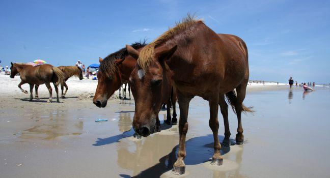
The Assateague Island National Seashore, established in 1962, occupies the northern two-thirds of a 37-mi-long barrier island, encompassing a small portion operated as Assateague State Park. ("Assateague" means "a marshy place across.") Although most famous for the small, shaggy, wild horses (adamantly called "ponies" by the public) that roam freely along the beaches and roads, this stunning island is also worth getting to know for its wildland, wildlife (including the beautiful sika deer), and for simply enjoying a pristine ocean-side environment. In summer the seashore's mild surf is where you can find shorebirds tracing the lapping waves back down the beach. There are three self-guided nature trails behind the dunes that encourage exploration of the island's forests and bay-side marshes.

Driving is permitted the length of—and several miles south of—the state park. Appropriate off-road vehicles with special permits may drive the length of the National Seashore as far as the Maryland-Virginia line. Remember that the animals here are wild, and follow the signs about not feeding or trying to pet the horses (or ponies).

Swimming, biking, hiking, surf fishing, picnicking, and camping are all available on the island. The visitor center at the entrance to the park has aquariums and hands-on exhibits about the seashore's birds and ocean creatures as well as the famous ponies.

7206 National Seashore La., Berlin, MD, 21811, USA
410-641--1441
Sight Details
Visitor center daily 9–5, park daily 24 hrs

Something incorrect in this review?

Governors Island

Financial District Fodor's Choice
Aerial view of  Manhattan and Governors Island, New York City, U.S.A. ; Shutterstock ID 212400088; Project/Title: 25 Things to Do in New York City This Spring; Downloader: Fodor's Travel
R.A.R. de Bruijn Holding BV / Shutterstock

Open year-round to the public (7 am–6 pm in winter; until 10 pm through the summer season) and accessible via ferry, Governors Island is essentially a big, charming park that resembles a small New England town. It's popular with locals for biking and walking by the water, festivals, art shows, concerts, and family programs, and delights visitors with a natural serenity—especially since it's in the middle of one of America's busiest harbors. In 1637, Wouter van Twiller, a representative for the country of Holland, supposedly purchased the island from the Indigenous Lenape people for his private use for two ax heads, a string of beads, and a handful of nails. In 1784, the island was named for English colonial governors and was used almost exclusively by the American military until the 1960s, when the Coast Guard took it over. In 2002, the city purchased the island and soon began reimagining its 172 acres as versatile public green space. The island's evolution continues with public art installations, all-ages park features (like slides and hammocks), various food and drink vendors, open-air Gitano Island modern-Mexican restaurant and club ( www.gitano.com/nyc), and even the QCNY ( www.qcny.com) luxury "destination day spa" inside the retired barracks. The Governors Island ferry departs from the Battery Maritime Building (free before 11 am on weekends, and daily for seniors, children, NYC ID  holders, and military), while the NYC Ferry links there from Wall Street/Pier 11, Brooklyn's Pier 6, and other docks in Manhattan and Brooklyn.

10 South St., New York, NY, USA
212-440–2200
Sight Details
Free (Pier 6 ferry either free or $5; all NYC Ferry tickets $4.50)

Something incorrect in this review?

Statue of Liberty

Financial District Fodor's Choice
NEW YORK - OCT 15: Aerial view of the Statue of Liberty and Ellis Island on Oct 15 2010. From 1892 to 1954, over 12 million immigrants entered USA through the portal of Ellis Island in New York Harbor; Shutterstock ID 151423415; Project/Title: 10 Things NO
ChameleonsEye / Shutterstock

For millions of immigrants, the first glimpse of America was the Statue of Liberty, and today it remains a powerful symbol of American ideals. Liberty Enlightening the World, as the statue is officially named, was presented to the United States in 1886 as a gift from France. The 152-foot-tall figure was sculpted by Frédéric-Auguste Bartholdi and erected around an iron skeleton engineered by Gustave Eiffel. It stands atop an 89-foot pedestal designed by Richard Morris Hunt, with Emma Lazarus's sonnet "The New Colossus" ("Give me your tired, your poor, your huddled masses . . .") inscribed on a bronze plaque at the base.

There is no admission fee for either the Statue of Liberty or Ellis Island, but an adult ferry ride (which goes round-trip to both Liberty Island and Ellis Island) costs $25.50, and includes entrance to the statue's pedestal and museum. Access to the statue's crown, via a famously narrow, twisting staircase, is strictly limited and tickets must be booked months in advance. Ferries leave from Battery Park (and from Liberty State Park in New Jersey) every 25–30 minutes depending on the time of year (buy your tickets online at  www.statuecruises.com). There are often long lines, so arrive early, especially if you have a timed-entry ticket (strongly recommended since they do sell out). There is a pleasant indoor-outdoor café on Liberty Island. In 2019, a new 26,000-square-foot museum opened on the island to showcase the statue's history and legacy, with artifacts including the statue's original torch, across three interactive galleries.

New York, NY, 10004, USA
212-363–3200
Sight Details
Free; ferry $25.50 round-trip (includes Ellis Island)

Something incorrect in this review?

Recommended Fodor's Video

Balboa Island

Fodor's Choice

In the middle of Newport Harbor is a charming community filled with quaint streets and multimillion-dollar cottages and homes with personal docks in their backyard. The island doesn't have a hotel, just vacation rentals available on VRBO and Airbnb. Stroll along Marine Avenue lined with picturesque cafés and apparel, decor, and souvenir stores. There are bicycle and walking paths encircling much of the island for an easy and scenic visit. 

To get here, you can either park your car on the mainland side of the PCH in Newport Beach and walk or bike over the bridge onto Marine Avenue, or take the Balboa Island Ferry.

Bald Head Island

Fodor's Choice

Reached by ferry from Southport, this beautiful 12,000-acre island resort is a self-contained, car-free community, complete with a grocery store, restaurants (Jules' Salty Grub, on the harbor, and AQUA, at the Shoals Club, are highlights), a marina, two B&Bs, two club complexes with restaurants and pools, and the gorgeous 18-hole George Cobb golf course. There are scores of rental properties, from shingled cottages to luxury homes. You can explore the semitropical island's maritime forest preserve and its 12 miles of deserted beaches on foot, by bicycle, or in a golf cart. Climb to the top of the quaint "Old Baldy" lighthouse, visit the Smith Island Museum to learn about the island's maritime history, watch the loggerhead turtles nest on the beach, or take a guided ghost walk. Walk out onto Cape Fear, the southern tip of the island where the infamous Frying Pan Shoals extend for 30 miles into the ocean, and you'll feel like you're standing on the edge of the continent—you are—and it becomes clear why so many shipwrecks have occurred in these shallow, shifting sands.  The 20-minute ferry ride costs $23 per person round-trip; for most of the year, it leaves Southport's Deep Point Marina on the hour and Bald Head Island on the half hour. Advance reservations are necessary for the ferry and resort. 

Boston Harbor Islands National Recreation Area

Waterfront Fodor's Choice

Comprising 34 tiny islands and peninsulas, this is one of the city's best hidden gems—and it's literally out of sight. Stretching from South Boston (Castle Island) to the coastlines of South Shore towns Hingham and Hull, each island is different, but most feature abundant nature with miles of lightly traveled trails, shoreline, sea life, and wild plants. The focal point is 39-acre Georges Island and its partially restored pre–Civil War Fort Warren that once held Confederate prisoners. Pets and alcohol are not allowed on the Harbor Islands.  Ferries shuttle visitors from Boston's Long Wharf to Georges, Thompson, and Spectacle islands daily during summer months. Plan to spend a whole day exploring!

191 W. Atlantic Ave., Boston, MA, 02110, USA
617-227–4321
Sight Details
$24.95 (round-trip ferry ticket)
Ferry schedule runs mid-May--mid-Oct. and goes from Boston to Georges, Thompson, and Spectacle islands

Something incorrect in this review?

Fort De Soto Park

Fodor's Choice

Spread over five small islands, 1,136-acre Fort De Soto Park lies at the mouth of Tampa Bay. It has 7 miles of waterfront (much of it beach); two fishing piers; a 4-mile hiking, cycling, and skating trail; picnic and camping grounds; and a historic fort that kids of any age can explore. For those traveling with their canine family members, there is a long and popular dog beach just north of the main fishing pier. Its namesake fort was built on the southern end of Mullet Key to protect sea lanes in the Gulf during the Spanish-American War.

Roam the fort or wander the beaches of any of the islands within the park. Kayaks and beach cruisers are available to rent, and mementos can be found at a souvenir shop/grill on the park's north side.

Sauvie Island

Fodor's Choice

When the weather's nice, drive about a half hour northwest of Downtown to this largely agrarian 33-square-mile piece of paradise in the Columbia River, containing a wildlife refuge, three beaches (including Collins Beach, which is clothing-optional), superb biking and hiking trails, and several farms offering seasonal "u-pick" bounty (and one, Bella Organic, offering wine tastings and an autumn pumpkin patch and corn maze). One excellent hike, and one of the few with free parking, is the Wapato Greenway, which leads through a white oak savannah and around a pond, where you may see green horned owls, nuthatches, and deer. Part of the trail leads to a peaceful dock on the Multnomah Channel, where you can tie up a boat or kayak. To get to the beaches, after crossing the Sauvie Island bridge, turn right; follow N.W. Sauvie Island Road to Reeder Road and follow signs. There's plenty of parking, but a permit is required ($10 for a one-day permit, $30 annual, available at the general store at the base of the bridge).

Seguin Island Light Station

Fodor's Choice

Perched at the top of a small island off the mouth of the Kennebec River, this cylindrical stone tower is one of the state’s prettiest and most imposing—it rises 52 feet above an already high headland. There's a small museum in the keeper's house, and the guest quarters can be rented. Camping is also permitted at the base of the lighthouse, and there are hiking trails. Access is by a short ferry ride from Fort Popham in Phippsburg. 

St. Helena Island

Fodor's Choice

Between Beaufort and Fripp Island lies St. Helena Island, a sizable sea island that is less commercial than the other islands in the area and home to a tight-knit Gullah community. The highlight here is Penn Center, a historic school and museum that was the first school for formerly enslaved people in 1862. Visitors can also see the Chapel of Ease ruins, go to Lands End and discover Fort Fremont Historical Park, or stop by roadside farms and local restaurants.

St. Paul Island

Fodor's Choice

The largest of the Pribilof Islands at 40 square miles, St. Paul Island is home to the greatest concentration of northern fur seals in the world—500,000 of them—and more than 180 varieties of birds. The island offers a guaranteed treat for folks who love birds and marine animals. The Unangax̂ people lived in the Aleutian Islands south of St. Paul and traditionally traveled to the Pribilofs seasonally for hunting. Russian fur traders claimed and named St. George, St. Paul, and St. Peter islands, and then enslaved and relocated Unangax̂ people in Atka, Siberia, and Unalaska to the islands to hunt for fur seals. Hundreds of descendants of these first nation people live in St. Paul year-round now, and the community has many elements of Unangax̂ culture as well as Russian Orthodox influences, easily seen in the Saints Peter and Paul Church, built in 1907. There's a small museum nearby.

Wizard Island

Fodor's Choice

The volcanic eruption that led to the creation of Crater Lake resulted in the formation of this magical island a ¼-mile off the lake's western shore. The views at its summit—reached on a somewhat challenging 2-mile hike—are stupendous.

Getting to the island requires a strenuous 1-mile hike down (and later back up) the steep Cleetwood Cove Trail to the cove's dock. There, board either the shuttle boat to Wizard Island or a Crater Lake narrated tour boat that includes a stop on the island. If you opt for the latter, you can explore Wizard Island a bit and reboard a later boat to resume the lake tour.

The hike to Wizard Summit, 763 feet above the lake's surface, begins at the island's boat dock and steeply ascends over rock-strewn terrain; a path at the top circles the 90-foot-deep crater's rim. More moderate is the 1¾-mile hike on a rocky trail along the shore of Wizard Island, so called because William Steel, an early Crater Lake booster, thought its shape resembled a wizard's hat.

Adams Key

Named Adams Key as early as the 1860s, the history of this minor key far exceeds its size. Roughly a century ago, as Miami began its transformation into a winter resort, some of the nation’s most noted figures looked down the coast and saw the strand of islands that made up the Upper Keys. Conveniently close to, but comfortably removed from, the busy pace of Miami, Adams Key became the home of the exclusive Cocolobo Cay Club, a private resort for the rich and famous that welcomed presidents Harding, Hoover, Johnson, and Nixon. It was an executive trend that might have continued had Hurricane Andrew not leveled what remained of the club in 1992.

The club relied on brothers Sir Lancelot and King Arthur Jones, who had developed a thriving pineapple and lime farm on adjacent Porgy Key and knew the bay’s best fishing spots. This inside information made the brothers indispensable to the club’s well-heeled guests.

Arguably less elegant today than in its heyday, the island has picnic areas with grills, restrooms, dockage, and a short trail running along the shore through a hardwood hammock. Accessible only by private boat, it’s fine for a day trip since no overnight docking is available—although that’s an option you’ll find at nearby Elliott and Boca Chita Keys.

Admiralty Island

The island is famous for its lush old-growth rain forest and abundant wildlife, including one of the largest concentrations of brown bears anywhere on the planet. The Tlingit name for the island is Kootznoowoo (Xootsnoowú), meaning "Fortress of the Bears." Ninety miles long, with 678 miles of coastline, Admiralty—the second-largest island in Southeast Alaska—is home to an estimated 1,600 bears, almost one per square mile.

Bailey Island

One of three islands that make up the town of Harpswell, Bailey Island is connected to the mainland by the world’s only cribstone bridge, made of enormous granite pieces of granite. So while you can take a ferry here, you can also just as easily drive. Come for the miles and miles of beautiful coastline; you can catch a gorgeous sunset (after a short hike) at the south end of the island, at Land's End Beach. Or seek out one of the local chartering companies and sign up for a day sail. Don't miss the rock formation known as the Giant’s Stairs or the 7-foot-tall lobsterman sculpture by Victor Kahill.

Bailey Island, ME, 04003, USA

Something incorrect in this review?

Beardslee Islands

You can reach the Beardslee Islands, which are havens for seals and harbor porpoise, by kayak through a small cut in the back of Bartlett Cove. The dozens of islands and islets, as well as the surrounding waters, are designated wilderness, making the area an easy way for paddlers to experience the backcountry and its solitude without having to buy a ticket on the day boat.
AK, USA

Something incorrect in this review?

Boca Chita Key

Echoes of the past ring across Boca Chita, which is listed on the National Register of Historic Places for its 10 historic structures. The park's most visited island was purchased in 1937 by Mark C. Honeywell, founder and CEO of today’s global conglomerate, and became a hip hangout, of sorts, when Honeywell invited his fellow entrepreneurs and industrialists to enjoy elegant island living and boisterous parties. Honeywell sold Boca Chita in 1942 after his wife was injured on the island and died before she could reach proper medical care. It was later enveloped into the collection of islands comprising Biscayne National Park.

Still here are a pavilion, a chapel, a 65-foot-high ornamental lighthouse (make arrangements with a ranger to climb it), and a garage that Honeywell built. Today's parties, however, consist of soirees held aboard yachts that tie up in the small harbor or more basic affairs amid tents pitched in the primitive campground. A half-mile hiking trail curves around the island's south side. Note that pets aren't allowed here, and there is no potable water (or sinks or showers) but rather just portable toilets. A $35 overnight (6 pm to 6 am) docking fee covers a campsite.

Chebeague Island

Great Chebeague Island

About 5 miles long and 1½ miles wide, Chebeague (pronounced shah-big) has a year-round population of about 390, which more than quadruples in the summer season. Originally used as a fishing ground by Abenaki Indigenous people, the island later became a place known for stone sloopingthose workers who carried ballast and granite for 19th-century ships, to be used in grand buildings. The island has a number of impressive Greek Revival homes built by them. There are a couple of small beaches, but most visitors come to spend time at the Chebeague Island Inn, where there's golf and tennis to play, and an excellent restaurant (with dreamy water views) open for lunch, dinner, or just drinks on the breezy porch.

Cliff Island

Cliff Island

Little wonder that the farthest island from Portland served by ferry service is also the most secluded and natural. Roads are unpaved, and most of the woods and beaches here are conservation land. Food isn't always easy to find here; there is only one store, and hours can be limited, so bring a lunch if you're looking to picnic. If a beach is on your agenda, head toward Stone Beach for great views of the nearby islands.

Casco Bay Islands, ME, 04019, USA

Something incorrect in this review?

Egmont Key State Park

In the middle of the mouth of Tampa Bay lies the small (350 acres), largely unspoiled but critically eroding island Egmont Key, now a state park, national wildlife refuge, national historic site, and bird sanctuary. On the island are the ruins of Ft. De Soto's sister fortification, Ft. Dade, built during the Spanish-American War to protect Tampa Bay. The primary inhabitants of the less-than-2-mile-long island are the threatened gopher tortoise and box turtles.

The only way to get here is by boat, and you can catch a ferry from Ft. De Soto, among other places; area operators include Hubbard's Marina, Dolphin Landings, and Island Boat Adventures. It's well worth the trip—the beach here is excellent for shelling, secluded beach bathing, wildlife viewing, and snorkeling.

Elliott Key

At 7 miles long from north to south, the park's largest key has a history that includes legends of pirates as well as the actual presence of pioneers, who began cultivating farms here in the late 1800s. In the 1950s, developers envisioned creating a tropical city called "Islandia" on this key. But it was the idea of creating a causeway needed to open the island to homes, as well as hotels and other businesses, that marked a turning point in the battle between developers and preservationists and ultimately led to the creation of Biscayne National Park. Today, without a hotel in sight, Elliott Key is a popular destination for boaters and campers.

A highlight here is a 30-foot-wide sandy shoreline, the park's only swimming beach, situated a mile north of the harbor on the island's west (bay) side. In addition to having a mile-long hiking trail, Elliott Key is home to the so-called Spite Highway, a clear-cut scar that runs approximately 6 miles down the center of the island. Carved out of spite by developers in their quest to turn the lush key into a commercial haven, the meaning has changed as nature continues to spite those developers by slowly and steadily reclaiming the land.

Overnight guests tie up their boats at one of the harbor's 33 slips or pitch tents at the campground, which has restrooms, picnic tables, grills, fresh drinking water, and cold showers. Either way, the fee is $35 per evening. Leashed pets are allowed in developed areas only, not on trails.

Great Diamond Island and Little Diamond

Great Diamond Island

Though most of Great Diamond is closed to the public, the Inn at Diamond Cove welcomes visitors and offers plenty to do. Housed in what was once Fort McKinley, a United States Army coastal defense fort built in the late 1800s and retired in the 1940s, it’s a combination resort, with several eateries as well as private residences. Guests can play tennis and indoor basketball, lounge at the pool, or use the complimentary bikes. Visitors often take the ferry just for the day, or for dinner at the property's fine dining establishment, Diamond's Edge. The area is car-free, so if you're not staying at the Inn, be prepared to explore on foot or bring your own bike.

Meanwhile, Little Diamond can be accessed on foot at low tide via Lamson Cove, and is filled with private residences, many of which can be rented during the summer months.

Casco Bay Islands, ME, 04109, USA

Something incorrect in this review?

Isles of Shoals

Four of the nine small, rocky Isles of Shoals belong to New Hampshire (the other five belong to Maine), many of them still known by the earthy names—Hog and Smuttynose, to cite but two—17th-century fishermen bestowed on them. A history of piracy, murder, and ghosts suffuses the archipelago, long populated by an independent lot who, according to one writer, hadn't the sense to winter on the mainland. Celia Thaxter, a native islander, romanticized these islands with her poetry in Among the Isles of Shoals (1873). In the late 19th century, Appledore Island became an offshore retreat for Thaxter's coterie of writers, musicians, and artists. Star Island contains a small museum, the Rutledge Marine Lab, with interactive family exhibits. From May to early October you can take a narrated history cruise of the Isles of Shoals and walking tours of Star Island with Isles of Shoals Steamship Company.

315 Market St., Portsmouth, NH, 03801, USA
800-441–4620
Sight Details
Cruises from $32
No cruises mid-Oct.–Apr.

Something incorrect in this review?

Jetty Island

Open in summer only, this 2-mile-long, sand-fringed offshore haven is full of wildlife and outdoor opportunities. Seasonal programs include guided walks, bonfires, and midsummer Jetty Island Days festivities. A ferry provides round-trip transportation.

Everett, 98201, USA
425-257–8304
Sight Details
Ferry $3 ferry, parking $3
Closed early Sept.–early July

Something incorrect in this review?

Long Island

Long Island

Three miles long and 1 mile wide, Long Island lives up to its name in shape, and is home to 200 year-round residents (many of whom work in the fishing industry) and 1,000 summer dwellers. There are a few lovely beaches here, including South Beach, Andrews Beach, and Fowler Beach. A few country stores and a bakery can supply you with vittles for a picnic. Bike rentals are not available, so bring your own over on the ferry or rent a golf cart close to the ferry landing when you arrive.

Mokolii

As you drive the windward and northern shores along Kamehameha Highway, a number of interesting geological features come into view. At Kualoa, look to the ocean at the uniquely shaped little island of Mokolii ("little lizard"), a 206-foot-high sea stack also known as Chinaman's Hat (for its hat-like shape). According to Hawaiian legend, the goddess Hiiaka, sister of Pele, slew the dragon Mokolii and flung its tail into the sea, forming the distinct islet. Other dragon body parts—in the form of rocks, of course—were scattered along the base of nearby Kualoa Ridge. Adventurous (and fit) folks can kayak out to Mokolii and scale its rocky sides, though it's not the easiest climb.

49-479 Kamehameha Hwy., Kaaawa, HI, 96744, USA

Something incorrect in this review?

Moku Ola

Also known as Coconut Island, this small island sits just offshore from Liliuokalani Gardens and is a nicely manicured spot where children play in the tide pools and anglers try their luck. Accessible via a footbridge, it was considered a place of healing and refuge in ancient times. There's a grassy picnic area, swimming spots, and a restroom, plus incredible views.

Hilo, HI, 96720, USA

Something incorrect in this review?

Nunivak Island

About 140 miles southwest of Bethel and separated from the Yukon-Kuskokwim Delta by the Etolin Strait, Nunivak Island is part of the Yukon Delta National Wildlife Refuge. The terrain includes interior craters and deep lakes from the island's volcanic origins, plus over 40 rivers and a tundra that gives way to shorelines and lagoons. The island sustains a large herd of reindeer managed by residents of the only permanent settlement on the island, the Cup'ik village of Mekoryuk. There's also a transplanted herd of musk ox, along with vast seabird colonies, migratory birds, and an array of sea mammals. For information on the island and travel options, contact the U.S. Fish and Wildlife Service in Bethel.

Peaks Island

Peaks Island

Nearest to Portland (only a 15-minute ferry ride away), this is the most developed of the Calendar Islands, but it still allows you to experience the relaxed pace of island life. Explore an art gallery or an old fort, and meander along the alternately rocky and sandy shore on foot, or rent a kayak, bike, or golf cart once off the ferry. A number of spots are open for both lunch and dinner.

The Fifth Maine Museum, a small museum with Civil War artifacts, open only in summer, is maintained in the building of the 5th Maine Regiment. ( 207/766–3330  www.fifthmainemuseum.org  $8). When the Civil War broke out in 1861, Maine was asked to raise a single regiment to fight, but the state came up with several (the number eventually totaled 40), and sent the 5th Maine Regiment into the war’s first battle, at Bull Run. The museum also offers guidebooks for a two-hour self-guided tour of the World War II Peaks Island Reservation.

Peirce Island

Jutting out into the Piscataqua River off the historic South End of the city, an easy walk over a short bridge from Strawbery Banke Museum and Prescott Park, this 27-acre island offers a welcoming patch of nature and maritime views. It's laced with shaded walking trails and has a huge kids' playground, a municipal swimming pool, and a boat ramp. You can also stroll across a narrow causeway to tiny Four Tree Island, which has picnic shelters, art installations, and benches, and even greater views of the river and passing ships.