
Goat Lick Overlook
Mountain goats frequent this natural salt lick on a cliff above the middle fork of the Flathead River. Watch the wildlife from an observation stand.
Get FREE email communications from Fodor's Travel, covering must-see travel destinations, expert trip planning advice, and travel inspiration to fuel your passion.

We've compiled the best of the best in Glacier National Park - browse our top choices for the top things to see or do during your stay.
Mountain goats frequent this natural salt lick on a cliff above the middle fork of the Flathead River. Watch the wildlife from an observation stand.
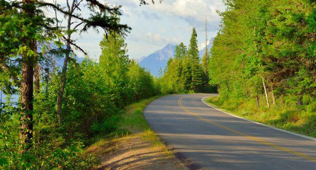
This magnificent, 50-mile highway—the only American roadway designated both a National Historic Landmark and a National Civil Engineering Landmark—crosses the crest of the Continental Divide at Logan Pass and traverses the towering Garden Wall. Open from mid-June to mid-September only (due to heavy snowfalls), this is one of the most stunning drives in Glacier National Park. A multiyear Sun Road rehabilitation project will result in some driving delays due to reconstruction. The drive is susceptible to frequent delays in summer. To avoid traffic jams and parking problems, take the road early in the morning or in the evening (when the lighting is ideal for photography and wildlife is most likely to appear). Glacier National Park Service operates a free hop on, hop off shuttle service from Apgar Visitor Centre to St. Mary Visitor Centre during the peak season. Vehicle size is restricted to under 21 feet long, 10 feet high, and 8 feet wide, including mirrors, between Avalanche Creek Campground and Sun Point. Cyclists enjoy traveling the open part of the road in early June before it is open to vehicular traffic.
From the Logan Pass parking lot, hike north along the Garden Wall and just below the craggy Continental Divide. Wildflowers dominate the 7.6 miles to Granite Park Chalet, a National Historic Landmark, where hikers with reservations can overnight. Return to Logan Pass along the same trail or hike down 4½ miles (a 2,500-foot descent) on the Loop Trail. Moderate.
On the southwest end of Lake McDonald, this tiny village has a few stores, an ice-cream shop, motels, ranger buildings, a campground, and a historic schoolhouse. A store called the Montana House is open year-round, but except for the weekend-only visitor center, no other services remain open from November to mid-May. Across the street from the visitor center,
This is a great first stop if you're entering the park from the west. Here you can get all kinds of information, including maps, permits, books, and the Junior Ranger newspaper, and you can check out displays that will help you plan your tour of the park. There is a variety of ranger-led programs including free snowshoe walks in winter. Snowshoes can be rented for $2 at the visitor center.
This picnic area is near two popular day hikes. There are tables, restrooms, and drinking water, and shuttle transfers are available in summer.
From Avalanche Creek Campground, take this 3-mile trail leading to mountain-ringed Avalanche Lake. The walk is only moderately difficult (it ascends 730 feet), making this one of the park's most accessible backcountry lakes. Crowds fill the parking area and trail during July and August and on sunny weekends in May and June. Moderate.
For a nice family hike, try the 1.3-mile path from the Sun Point parking area. It leads to a spruce and Douglas fir woods; cross a log bridge over Baring Creek and you arrive at the base of gushing Baring Falls. Easy.
You'll see the striking contrast of prairies and mountains as you travel northwest from East Glacier Park Village to Two Medicine Lake on Route 49. Once you turn onto Two Medicine Road, you'll be heading straight toward snowcapped peaks and lovely Two Medicine Lake. From there, head back out to Route 49 and then to U.S. 89 North to make your way to the town of St. Mary and then onto the Going-to-the-Sun Road to reach St. Mary Lake, the park's second largest. The entire route is 49 miles one-way. End the drive with an additional stop at Swiftcurrent Lake, and you'll cover about 75 miles total.
In a forested area adjacent to Lake McDonald, this picnic area has tables, drinking water, and restrooms. Nearby there's a swimming area and several trailheads.
An abrupt and jagged wall of rock juts above the road and is visible for about 10 miles as it follows Logan Creek from just past Avalanche Creek Campground to Logan Pass.
In 1926, one giant ice mass broke apart to create the Salamander and Grinnell glaciers, which have been shrinking ever since. The 5½-mile trail to Grinnell Glacier, the park's most accessible, is marked by several spectacular viewpoints. You start at Swiftcurrent Lake's picnic area, climb a moraine to Lake Josephine, then climb to the Grinnell Glacier overlook. Halfway up, turn around to see the prairie land to the northeast. You can cut about 2 miles (each way) off the hike by taking scenic boat rides across Swiftcurrent Lake and Lake Josephine. From July to mid-September, a ranger-led hike departs from the Many Glacier Hotel boat dock on most mornings at 8:30. Difficult.
Hidden Lake Overlook is an easy, 1½-mile hike from the Logan Pass Visitor Center. Along the way, you'll pass through beautiful alpine meadows known as the Hanging Gardens. Enjoy incredible views of Hidden Lake, Bearhat Mountain, Mt. Cannon, Fusillade Mountain, Gunsight Mountain, and Sperry Glacier. It's common to see mountain goats near the overlook. If you want a challenge, continue hiking all the way down to the edge of the lake—a moderate 5.4-mile round-trip hike. Easy to moderate.
This moderately strenuous, 9-mile, round-trip hike passes the gushing Ptarmigan Falls, then climbs to its namesake, where icebergs bob in the chilly mountain loch. Mountain goats hang out on sheer cliffs above, bighorn sheep graze in the high mountain meadows, and grizzly bears dig for glacier lily bulbs, grubs, and other delicacies. Rangers lead hikes here almost daily in summer, leaving at 8:30 am. Moderate.
On the eastern side of the Continental Divide, you come into view of Jackson Glacier looming in a rocky pass across the upper St. Mary River valley. If it isn't covered with snow, you'll see sharp peaks of ice. The glacier is shrinking and may disappear in another 100 years.
This beautiful, 10-mile-long lake, the parks' largest, is accessible year-round from Going-to-the-Sun Road. Cruise to the middle for a view of the surrounding glacier-clad mountains. You can fish and horseback ride at either end, and in winter, snowshoe and cross-country ski.
At 6,646 feet, this is the park's highest point accessible by motor vehicle. Crowded in July and August, it offers unparalleled views of both sides of the Continental Divide. Mountain goats, bighorn sheep, and grizzly bears frequent the area. The Logan Pass Visitor Center is just east of the pass.
Built of stone, this center stands sturdy against the severe weather that forces it to close in winter. When it's open, rangers give 10-minute talks on the alpine environment and offer a variety of activities including guided hikes. You can get advice from them and buy books and maps.
You've found the power center of Montana at this wacky roadside attraction, where the laws of physics don't apply, and mystifying phenomena prevail.
On the banks of the North Fork of the Flathead River on Glacier National Park's western edge, this tiny community (population 25) has just one store, one restaurant and saloon, one camp store, and one hostel, yet it is a gem in the wilderness. You can see where a massive wildfire burned up to some of the buildings in 1988 and how quickly new growth has advanced. The entrance station, staffed in summer only, is the gateway to Bowman and Kintla lakes, as well as Logging and Quartz lakes, which are in the backcountry and accessible only by hiking trails. The bakery at the Polebridge Mercantile store is amazing, with huckleberry macaroons or bear claws and hot, gooey cinnamon buns.
In a cottonwood grove adjacent to St. Mary Lake, this area has tables, restrooms, and drinking water in the summer.
Enjoy fantastic mountain and lake views on this family-friendly, 1.9-mile trail along the western shore of Lake McDonald. Easy.
Cascading near Two Medicine, these are actually two different waterfalls from two different sources. In spring, when the water level is high, the upper falls join the lower falls for a 40-foot drop into Two Medicine River; in summer, the upper falls dry up, revealing the lower 20-foot falls that start midway down the precipice.
This picnic site on Lake McDonald's eastern shore has tables, restrooms, and drinking water in summer.
When the breezes calm, the park's second-largest lake mirrors the snowcapped granite peaks that line the St. Mary Valley. To get a good look at the beautiful scenery, follow the Sun Point Nature Trail along the lake's shore. The hike is 1 mile each way.
Glacier's largest visitor complex has a huge relief map of the park's peaks and valleys and screens a 15-minute orientation video. Exhibits help visitors understand the park from the perspective of its original inhabitants—the Blackfeet, Salish, Kootenai, and Pend d'Orielle peoples. Rangers conduct evening presentations in summer, and the auditorium hosts Native America Speaks programs. The center also has books and maps for sale, backcountry camping permits, and large viewing windows facing the 10-mile-long St. Mary Lake.
Railroad history, local gags like a fur-covered trout, and fine black-and-white photo displays complete this eclectic collection housed track-side at the Amtrak station in the Whitefish Railroad Depot. While browsing in the gift shop, ask for a free historical walking-tour map of "Stumptown," Whitefish's nickname. Call to confirm hours before stopping by.
A stunning waterfall awaits at the end of this well-groomed, 1.3-mile trail along the cliffs and shores of picturesque St. Mary Lake. You can hike one-way and take a boat transfer back. Easy.
The Many Glacier Hotel is perched on the shores of Swiftcurrent Lake. The views here are some of the park's prettiest, taking in the mountains that rise more than 3,000 feet immediately west of the lake. Scenic boat tours ply the waters and transport hikers to trails that lead to other lakes and glaciers in the park's Many Glacier region.


