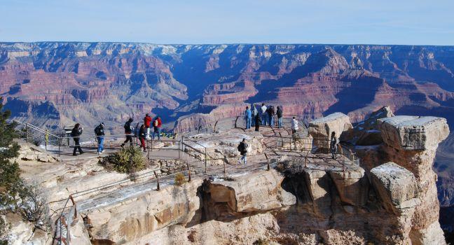
66 Best Sights in Grand Canyon National Park, Arizona

Background Illustration for Sights

We've compiled the best of the best in Grand Canyon National Park - browse our top choices for the top things to see or do during your stay.

Bright Angel Point

Fodor's choice

Bright Angel Point is one of the most awe-inspiring overlooks on either rim. To get to it, follow the trail that starts on the grounds of the Grand Canyon Lodge and runs along the crest of a point of rocks that juts into the canyon for several hundred yards. The walk is only ½ mile round-trip, but it's an exciting trek accented by sheer drops on each side of the trail. In a few spots where the route is extremely narrow, metal railings ensure visitors' safety. The temptation to clamber out on precarious perches to have your picture taken should be resisted at all costs.

North Rim Dr., AZ, 86052, USA

Something incorrect in this review?

Bright Angel Trail

Fodor's choice

This well-maintained trail is one of the most scenic (and busiest) hiking paths from the South Rim to the bottom of the canyon (9.6 miles each way). Rest houses are equipped with water at the 1½- and 3-mile points from May through September and at Havasupai Gardens (4 miles) year-round. Water is also available at Bright Angel Campground, 9¼ miles below the trailhead. Plateau Point, on a spur trail about 1½ miles below Havasupai Gardens, is as far as you should attempt to go on a day hike; the round-trip will take six to nine hours.

Bright Angel Trail is the easiest of all the footpaths into the canyon, but because the climb out from the bottom is an ascent of 5,510 feet, the trip should be attempted only by those in good physical condition and should be avoided in midsummer due to extreme heat. The top of the trail can be icy in winter. Originally a bighorn sheep path and later used by the Havasupai, the trail was widened late in the 19th century for prospectors and is now used for both mule and foot traffic. Also note that mule trains have the right-of-way—and sometimes leave unpleasant surprises in your path. Moderate.

AZ, 86023, USA

Something incorrect in this review?

Grand Canyon Skywalk

Fodor's choice

This cantilevered glass terrace is suspended nearly 4,000 feet above the Colorado River and extends 70 feet from the edge of the Grand Canyon. Approximately 10 feet wide, the bridge's deck, made of tempered glass several inches thick, has 5-foot glass railings on each side creating an unobstructed open-air platform. Admission to the skywalk is an add-on to the basic Grand Canyon West admission. Visitors must store personal items, including cameras, cell phones, and video cameras, in free lockers before entering. A professional photographer takes photographs of visitors, which can be purchased from the gift shop.

Recommended Fodor's Video

Havasu Falls

Fodor's choice

Havasu Canyon has five major waterfalls. The first three—Fifty Foot Falls, Little Navajo Falls, and Havasu Falls—sit between the village of Supai and the Havasu Falls Campground; Mooney Falls and Beaver Falls are past the campground on the way to the confluence of the Colorado River. Often overlooked because it’s a short trek off Hualapai Trail, Fifty Foot Falls typically has fewer crowds than Little Navajo Falls, roughly 30 feet farther down Havasu Creek. The large turquoise pools of Havasu Falls make a great place to cool off with a swim. Getting to the waterfalls past the campground becomes a little more challenging. Water spray from Mooney Falls, a ½ mile from the campground, makes the descent to its base slick, especially on the rock stairs near the end. But the effort rewards with awe-inspiring views of the water plunging 190 feet into a colorful pool. Beaver Falls is another 2 miles farther down the trail and offers multiple swimming holes. Visitors often bring inflatable water tubes to float in the pools, in addition to extra towels and plenty of sunscreen. Water shoes for walking on slippery travertine are highly recommended.

Highway 67

Fodor's choice

Open mid-May to roughly mid-October (or the first big snowfall), this two-lane paved road climbs 1,400 feet in elevation as it passes through the Kaibab National Forest. Also called the North Rim Parkway, this scenic route crosses the limestone-capped Kaibab Plateau—passing broad meadows, sun-dappled forests, and small lakes and springs—before abruptly falling away at the abyss of the Grand Canyon. Wildlife abounds in the thick ponderosa pine forests and lush mountain meadows. It's common to see deer, turkeys, and coyotes as you drive through such a remote region. Point Imperial and Cape Royal branch off this scenic drive, which runs from Jacob Lake to Bright Angel Point.

Hopi Point

Fodor's choice

From this elevation of 7,071 feet, you can see a large section of the Colorado River; although it appears as a thin line, the river is nearly 350 feet wide. The overlook extends farther into the canyon than any other point on Hermit Road. The incredible unobstructed views make this a popular place to watch the sunset.

Across the canyon to the north is Shiva Temple. In 1937 Harold Anthony of the American Museum of Natural History led an expedition to the rock formation in the belief that it supported life that had been cut off from the rest of the canyon. Imagine the expedition members' surprise when they found an empty Kodak film box on top of the temple—it had been left behind by Emery Kolb, who felt slighted for not having been invited to join Anthony's tour.

Directly below Hopi Point lies Dana Butte, named for a prominent 19th-century geologist. In 1919 an entrepreneur proposed connecting Hopi Point, Dana Butte, and the Tower of Set across the river with an aerial tramway, a technically feasible plan that fortunately has not been realized.

Hualapai Trail

Fodor's choice

The trail in and out of Havasu Canyon begins at Hualapai Hilltop, 90 minutes from Peach Springs, and drops about 1,800 feet in the first 2 miles, followed by 1½ miles of switchbacks. The remaining 4½ miles to the tiny village of Supai (a total of 8 miles from the trailhead parking lot) is relatively flat. From Supai, the trail begins to parallel Havasu Creek and passes the first three major waterfalls: Fifty Foot Falls, Little Navajo Falls, and Havasu Falls. Havasu Falls Campground sits 10 miles from the trailhead (2 miles from Supai), but the trail continues. Just a ½ mile from the campground is Mooney Falls, which requires navigating rocks slick with water spray to get to its base. Two miles past that, Beaver Falls is the last major waterfall on the trail, but hikers can continue all the way to the confluence of the Colorado River on the Hualapai Trail, an additional 4 miles. In total, the Hualapai Trail is 12 miles each way from Hualapai Hilltop to Beaver Falls (16 miles to the Colorado River). You must have a permit to enter Havasu Canyon or you will be turned away. Hualapai Trail is not a day hike; you must have reservations either at Havasupai Lodge or the campground before you go. Because there is no available drinking water on the trail, you will have to bring your own. Packing mules can be arranged in advance to carry your gear in and out of the canyon (give them the right of way on the trail) through the Havasupai Tribe Tourism, and helicopter rides are available for $85 on a first-come, first-served basis for visitors who don't feel they can hike back out.

Mather Point

Fodor's choice

You'll likely get your first glimpse of the canyon from this viewpoint, one of the most impressive and accessible (next to the main visitor center plaza) on the South Rim. Named for the National Park Service's first director, Stephen Mather, this spot yields extraordinary views of the Grand Canyon, including deep into the inner gorge and numerous buttes: Wotans Throne, Brahma Temple, and Zoroaster Temple, among others.

Point Sublime

Fodor's choice

You can camp within feet of the canyon's edge at this awe-inspiring site. Sunrises and sunsets are spectacular. The winding road, through gorgeous high country, is only 17 miles, but it will take you at least two hours one-way. The road is intended only for vehicles with high road clearance (pickups and four-wheel-drive vehicles). It is also necessary to be properly equipped for wilderness road travel. Check with a park ranger or at the information desk at Grand Canyon Lodge before taking this journey. You may camp here only with a permit from the Backcountry Information Center.

North Rim Dr., AZ, 86052, USA

Something incorrect in this review?

Rim Trail

Fodor's choice

The South Rim's most popular walking path is the 12.8-mile (one-way) Rim Trail, which runs along the edge of the canyon from Pipe Creek Vista (the first overlook on Desert View Drive) to Hermits Rest. This walk, which is paved to Maricopa Point and for the last 1½ miles to Hermits Rest, visits several of the South Rim's historic landmarks. Allow anywhere from 15 minutes to a full day, depending on how much of the trail you want to cover; the Rim Trail is an ideal day hike, as it varies only a few hundred feet in elevation from Mather Point (7,120 feet) to the trailhead at Hermits Rest (6,650 feet). The trail can also be accessed from several spots in Grand Canyon Village and from the major viewpoints along Hermit Road, which are serviced by shuttle buses during the busy summer months. On the Rim Trail, water is available only in the Grand Canyon Village area and at Hermits Rest. Easy.

AZ, 86023, USA

Something incorrect in this review?

Yavapai Point

Fodor's choice

Dominated by the Yavapai Geology Museum and Observation Station, this point displays panoramic views of the mighty gorge through a wall of windows. Exhibits at the museum include videos of the canyon floor and the Colorado River, a scaled diorama of the canyon with national park boundaries, fossils, and rock fragments used to re-create the complex layers of the canyon walls, and a display on the natural forces used to carve the chasm. Dig even deeper into Grand Canyon geology with free daily ranger programs. This point is also a good location to watch the sunset.

Grandview Point

Tourists at the Grand Canyon taken from Grandview Point overlook South rim.
Phlens | Dreamstime.com

At an elevation of 7,399 feet, the view from here is one of the finest in the canyon. To the northeast is a group of dominant buttes, including Krishna Shrine, Vishnu Temple, Rama Shrine, and Sheba Temple. A short stretch of the Colorado River is also visible. Directly below the point, and accessible by the steep and rugged Grandview Trail, is Horseshoe Mesa, where you can see remnants of Last Chance Copper Mine.

AZ, 86023, USA

Something incorrect in this review?

The Abyss

At an elevation of 6,720 feet, the Abyss is one of the most awesome stops on Hermit Road, revealing a sheer drop of 3,000 feet to the Tonto Platform, a wide terrace of Tapeats sandstone about two-thirds of the way down the canyon. From the Abyss you'll also see several isolated sandstone columns, the largest of which is called The Monument.

AZ, 86023, USA

Something incorrect in this review?

Cape Final Trail

This 4-mile round-trip gravel path follows an old Jeep trail through a ponderosa pine forest to the canyon overlook at Cape Final with panoramic views of the northern canyon, the Palisades of the Desert, and the impressive spectacle of Juno Temple. Easy.

AZ, 86023, USA

Something incorrect in this review?

Cape Royal

A popular sunset destination, Cape Royal showcases the canyon's jagged landscape; you'll also get a glimpse of the Colorado River, framed by a natural stone arch called Angels Window. In autumn, the aspens turn a beautiful gold, adding even more color to an already magnificent scene of the forested surroundings. The easy and rewarding 1-mile round-trip hike along Cliff Springs Trail starts here; it takes you through a forested ravine and terminates at Cliff Springs, where the forest opens to another impressive view of the canyon walls.

Cape Royal Scenic Dr., AZ, 86052, USA

Something incorrect in this review?

Cape Royal Trail

Informative signs about vegetation, wildlife, and natural history add to this popular 0.8-mile, round-trip, paved path to Cape Royal; allow at least one hour round-trip. At an elevation of 7,685 feet on the southern edge of the Walhalla Plateau, this popular viewpoint offers expansive views of Wotans Throne, Vishnu Temple, Freya Castle, Horseshoe Mesa, and the Colorado River. The trail also offers several nice views of Angels Window. Easy.

AZ, 86023, USA

Something incorrect in this review?

Clear Creek Trail

This multiday, 9-mile hike (each way) departs from Phantom Ranch at the bottom of the canyon and crosses the Tonto Platform to Clear Creek, where drinking water is usually available but should be treated. You can continue an additional 6 miles to the Colorado River and, from that point, it's another 5 miles to Cheyava Falls, which flows in the spring after a winter of heavy snows. These last two legs extend the hike several days and require some scrambling and free climbing. Because the slope is south-facing and has no shade, this trail shouldn't be attempted in the summer. Moderate.

AZ, 86023, USA

Something incorrect in this review?

Cliff Spring Trail

An easy 1-mile (round-trip), one-hour walk near Cape Royal, Cliff Spring Trail leads through a forested ravine to an excellent view of the canyon. The trailhead begins at the Cape Royal parking lot, across from Angels Window Overlook. Narrow and precarious in spots, it passes ancient dwellings, winds beneath a limestone overhang, and ends at Cliff Springs.  Do not drink the water. Easy.

AZ, 86023, USA

Something incorrect in this review?

Desert View Drive

This heavily traveled 25-mile stretch of road follows the rim from the east entrance to Grand Canyon Village. Starting from the less congested entry near Desert View, road warriors can get their first glimpse of the canyon from the 70-foot-tall watchtower, the top of which provides the highest viewpoint on the South Rim. Six developed canyon viewpoints in addition to unmarked pullouts, the remains of an Ancestral Puebloan dwelling at the Tusayan Ruin and Museum, and the secluded and lovely Buggeln picnic area make for great stops along the South Rim. The Kaibab Rim Route shuttle bus travels a short section of Desert View Drive and takes 50 minutes to ride round-trip without getting off at any of the stops: Grand Canyon Visitor Center, South Kaibab Trailhead, Yaki Point, Pipe Creek Vista, Mather Point, and Yavapai Geology Museum.

AZ, USA

Something incorrect in this review?

Desert View Information Center

Near the Desert View Watchtower, this nonprofit Grand Canyon Association store and information center has a nice selection of books, park pamphlets, gifts, and educational materials. It's also a handy place to pick up maps and info if you enter the park at the eastern entrance. All sales from the Association stores go to support park programs.

Eastern entrance, AZ, 86023, USA
800-858–2808

Something incorrect in this review?

Desert View Watchtower

From the top of the 70-foot stone-and-mortar watchtower with its 360-degree views, even the muted hues of the distant Painted Desert to the east and the Vermilion Cliffs rising from a high plateau near the Utah border are visible. In the chasm below, angling to the north toward Marble Canyon, an imposing stretch of the Colorado River reveals itself. Up several flights of stairs, the watchtower houses a glass-enclosed observatory with telescopes.

AZ, 86023, USA
928-638–7888
Sight Details
Free

Something incorrect in this review?

Eagle Point

The heart of Grand Canyon West, this scenic overlook is where you'll find the Skywalk, the Sky View Restaurant, a café, replicas of Native American structures, and a shop where you can purchase authentic Native American crafts. Hualapai musicians and dancers perform Friday, Saturday, and Sunday from 10 am to 3 pm at the outdoor amphitheater here.

Grand Canyon Verkamp's Visitor Center

This small visitor center is named for the Verkamp family, who operated a curios shop on the South Rim for more than a hundred years. The building serves as an official visitor center, ranger station (get your Junior Ranger badges here), bookstore, and museum, with compelling exhibits on the Verkamps and other pioneers in this region.

Desert View Dr., AZ, 86023, USA
928-638–7146

Something incorrect in this review?

Grand Canyon Visitor Center

The park's main orientation center provides pamphlets and resources to help plan your visit. It also holds engaging interpretive exhibits on the park. Rangers are on hand to answer questions and aid in planning canyon excursions. A daily schedule of ranger-led hikes and evening lectures is available, and a 20-minute film about the history, geology, and wildlife of the canyon plays every 30 minutes in the theater. The bicycle rental office, a small café, and a huge gift store are also in this complex. It's a five-minute walk from here to Mather Point, or a short ride on the shuttle bus, which can take you into Grand Canyon Village. The visitor center is also accessible from the village via a leisurely 2-mile walk on the Greenway Trail, a paved pathway that meanders through the forest.

450 Hwy. 64, AZ, 86023, USA
928-638–7888

Something incorrect in this review?

Grand Canyon West

Grand Canyon West, run by the Hualapai tribe, offers a basic admission ticket, which includes a Hualapai visitation permit and hop-on, hop-off shuttle transportation to three sites. The shuttle will take you to Eagle Point, where you can tour authentic dwellings at the Indian Village and view educational displays on the culture of five different Native American tribes (Havasupai, Plains, Hopi, Hualapai, and Navajo). Intertribal dance performances entertain visitors at the nearby amphitheater. The shuttle also goes to Hualapai Point, site of zip-lining, horseback rides, and the only lodging on the West Rim, and Guano Point, where the "High Point Hike" offers panoramic views of the Colorado River. At all three areas, local Hualapai guides add a Native American perspective.

For extra fees, you can add meals (there are cafés at each of the three stops), overnight lodging at Hualapai Point, a helicopter trip into the canyon, zip-lining, a rafting trip on the Colorado, a horseback ride along the canyon rim, or a walk on the Grand Canyon Skywalk.

Grand Canyon West, Peach Springs, AZ, USA
928-769–2636
Sight Details
From $51

Something incorrect in this review?

Grandview Trail

Accessible from the parking area at Grandview Point, the trailhead is at 7,400 feet. The path heads steeply down into the canyon for 3 miles to the junction and campsite at East Horseshoe Mesa Trail. Classified as a wilderness trail, the route is aggressive and not as heavily traveled as some of the more well-known trails, such as Bright Angel and Hermit. There is no water available along the trail, which follows a steep descent to 4,900 feet at Horseshoe Mesa, where Hopi Indians once collected mineral paints. Hike 0.7 mile farther to Page Spring, a reliable water source year-round. Parts of this trail are icy in winter, and traction crampons are mandatory. Difficult.

AZ, 86023, USA

Something incorrect in this review?

Guano Point

Named for the nitrogen-rich bat droppings (guano) that were mined from a cave across the canyon, Guano Point boasts the most spectacular landscapes at the West Rim. You'll have to make a short hike from the shuttle drop-off to get to the no-longer-functioning aerial tramway at the point, but once there, you'll be rewarded with nearly 360-degree views of the canyon and the river below. Guano Point Cafe serves BBQ and curried vegetables.

AZ, USA

Something incorrect in this review?

Havasu Canyon

South of the middle part of the Grand Canyon National Park's South Rim and away from the crowds, Havasu Canyon is the home of the Havasupai, a tribe that has lived in this isolated area for centuries. You'll discover why they are known as the "people of the blue-green waters" when you see the canyon's waterfalls—Fifty Foot Falls, Little Navajo Falls, Havasu Falls, Beaver Falls, and Mooney Falls. Accumulated travertine formations in some of the most popular pools were washed out in massive flooding decades ago and again in 2008 and 2010, but it's still a magical place.

The village of Supai, which currently has about 200 tribal residents, is accessed by the 8-mile-long Hualapai Trail, which drops 2,000 feet from the canyon rim to the tiny town.

To reach Havasu's waterfalls, you must hike downstream from the village of Supai. Pack adequate food and supplies. There is a café and a trading post in the village, but prices for food and sundries are more than double what they would be outside the reservation. The tribe does not allow alcohol, drugs, pets, drones, or weapons. Reservations are necessary for camping or staying at Havasupai Lodge.

Hermit Road

The Santa Fe Company built Hermit Road, formerly known as West Rim Drive, in 1912 as a scenic tour route. Nine overlooks dot this 7-mile stretch, each worth a visit. The road is filled with hairpin turns, so make sure you adhere to posted speed limits. A 1½-mile Greenway trail offers easy access to cyclists looking to enjoy the original 1912 Hermit Rim Road. From March through November, Hermit Road is closed to private auto traffic because of congestion; during this period, a free shuttle bus carries visitors to all the overlooks. Riding the bus round-trip without getting off at any of the viewpoints takes 80 minutes; the return trip stops only at Hermits Rest, Pima, Mohave, and Powell Points.

AZ, USA

Something incorrect in this review?

Hermit Trail

Beginning on the South Rim just west of Hermits Rest (and 7 miles west of Grand Canyon Village), this steep, unmaintained, 9.7-mile (one-way) trail drops more than 5,000 feet to Hermit Creek, which usually flows year-round. It's a strenuous hike back up and is recommended for experienced long-distance hikers only; plan for six to nine hours. There's an abundance of lush growth and wildlife, including desert bighorn sheep, along this trail. The trail descends from the trailhead at 6,640 feet to the Colorado River at 2,300 feet. Day hikers should not go past Santa Maria Spring at 5,000 feet (a 5-mile round-trip).

For much of the year, no water is available along the way; ask a park ranger about the availability of water at Santa Maria Spring and Hermit Creek before you set out. All water from these sources should be treated before drinking. The route leads down to the Colorado River and has inspiring views of Hermit Gorge and the Redwall and Supai formations. Six miles from the trailhead are the ruins of Hermit Camp, which the Santa Fe Railroad ran as a tourist camp from 1911 until 1930. Difficult.

AZ, 86023, USA

Something incorrect in this review?