

66 Best Sights in Mexico

Background Illustration for Sights

We've compiled the best of the best in Mexico - browse our top choices for the top things to see or do during your stay.

Monte Albán

Fodor's Choice
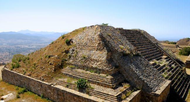
The pyramid ruins of Monte Alban - Oaxaca, Mexico
Nfoto / Shutterstock

The massive temples of Monte Albán, perched atop a mesa, make this one of the country's most spectacular archaeological sites. This vast city was home to more than 30,000 Zapotec. Despite its size, experts estimate that only about 10% of the site has been uncovered. Digs are sporadic, taking place whenever the budget permits.

Monte Albán overlooks the Oaxaca Valley from a flattened mountaintop 5,085 feet high; the views are breathtaking. Either the Zapotec or their predecessors leveled the site around 600 BC. The varying heights of the site follow the contours of distant mountains. The oldest of the four temples is the Galería de los Danzantes, or the Dancers' Gallery, so named for the elaborately carved stone figures that once covered the building. Most of the originals are now in the site museum, but you can still see some in the temple. Experts are unsure whether the nude male figures represent captives, warriors, or some other group; the theory that they were dancers has been discarded because some appear to be bound.

The Zapotec constructed most of the buildings along a north–south axis, except for the so-called Observatorio (Observatory). The arrow-shape structure is set at a 45-degree angle, pointing toward the southwest. It's thought to have been an observatory, as it's more closely aligned with the stars than with the Earth's poles.

The Juego de Pelota, or ball game, was played in the well-excavated court. Hips, shoulders, knees, and elbows were probably used to hit a wooden or rubber ball. The details of these games are sketchy, but there's speculation that they were a means of solving disputes between factions or villages, of celebrating the defeat of a rival, or of worshipping the gods. Although human sacrifice is thought to have been connected with the ball game in certain parts of Mesoamerica, there's no evidence that it happened in Monte Albán.

No one knows for sure whether the Zapotec abandoned the site gradually or suddenly, but by AD 1000 it stood empty. Years afterward the Mixtec used Monte Albán as a lofty necropolis of lavish tombs. More than 200 tombs and 300 burial sites have been explored. The most fantastic of these, Tumba 7, yielded a treasure unequaled in North America. Inside were more than 500 priceless Mixtec objects, including gold breastplates; jade, pearl, ivory, and gold jewelry; and fans, masks, and belt buckles of precious stones and metals. The tomb is north of the parking lot but is seldom open.

At Monte Albán you'll find a small site museum with a gift shop. The cafeteria isn't half bad, and has a great view of the valley; sadly, it closes with the rest of the site at 5 pm.

Chichén Itzá

Fodor's Choice

Little is known about those who founded this dramatic, 6-square-km (2¼-square-mile) metropolis. Some structures, likely built in the 5th century, predate the arrival of the Itzá, the people who occupied the city starting around the late 8th and early 9th centuries. Why they abandoned it in the early 1200s is also unknown, as is its subsequent role. What is known is that the city's name means "the mouth of the well of the Itzá," likely referring to the site's several cenotes—valuable sources of water.

Dominating Mexico's most stunning and well-preserved Maya site is El Castillo (The Castle), also known by its Mayan name, Kukulkán. The much-photographed pyramid is remarkable not only for its size, but also for its perfectly proportioned symmetry. Adorning the corners of its four stairways (no, climbing is not allowed) are open-jawed serpent statues that honor the priest-king Kukulcán (aka Quetzalcóatl), an incarnation of the feathered serpent god. More serpents appear in sculpted columns atop the building.

At the spring and fall equinoxes, the afternoon light strikes the pyramid so that the snake god's shadow appears to undulate down the side of it to bless the fertile earth. Thousands of people, from sightseers to shamans, travel here to witness this phenomenon. Make lodging reservations far in advance if you hope to join them.

Archaeologists are still abuzz about the 2015 discovery of a subterranean river flowing underneath the pyramid, detected via “electrical resistance survey.” Although the Maya would likely have intentionally constructed El Castillo over such a river cavern, there is concern that this will lead to the formation of a gigantic sinkhole that would threaten the structure’s foundation. Although experts say this would probably not happen for several generations, time will tell.

Just west of El Castillo is another highlight: the Anexo del Templo de los Jaguares (Annex to the Temple of the Jaguars), where bas-relief carvings represent still other important deities. To its west is the Juego de Pelota, the city's main ball court. Remarkably, if you stand at one end of it and whisper something, it will be heard all the way at the other end. The game played on this ball court was apparently something like soccer (no hands were used), but it likely had some sort of ritualistic significance. (Note that the Mérida tourist offices stages a popular demonstration of the ball game each Friday evening in front of the cathedral.)

On the other side of El Castillo, just before a small temple dedicated to the planet Venus, a ruined sacbé, or raised white road, leads to the Cenote Sagrado (Holy Well), which was probably for ritualistic purposes. The nearby Cenote Xtaloc was kept pristine, undoubtedly for bathing and drinking. Adjacent to it is a steam bath, outside of which is a tiny pool that was used for cooling down.

Older Maya structures lie south and west of Cenote Xtaloc. Archaeologists have been restoring several buildings in this area, including the Templo del Osario (Ossuary Temple), which concealed several tombs with skeletons and offerings. Behind the smaller Casa Roja (Red House) and Casa del Venado (House of the Deer) are the site's oldest structures, including El Caracol (The Snail), a round building—rare in Maya architecture—with an interior spiral staircase. With eight tiny windows precisely aligned with the points of the compass rose, it was seemingly built as a celestial observatory.

If the Maya gods are smiling, the evening sound-and-light show—which features images projected on El Castillo—won't be plagued by technical issues during your visit. Though some say the show is cheesy, others say it's stunning. Regardless, it offers a different perspective on this remarkable site. It takes place at 8 pm from April through October and at 7 pm the rest of the year. Reservations are required, and you can make them online ( nochesdekukulkan.com.mx) or through a tour operator. Tickets are pricey but include a 30-minute pre-show guided walk and use of a translation device (original narration is in Spanish only).

Cobá Ruins

Fodor's Choice

Mayan for "water stirred by the wind," Cobá flourished from AD 800 to 1100, with a population of as many as 55,000. Now it stands in solitude, and the jungle has overgrown many of its buildings—the silence is broken only by the occasional shriek of a spider monkey or the call of a bird. Most of the trails here are pleasantly shaded; processions of huge army ants cross the footpaths as the sun slips through openings between the tall hardwood trees, ferns, and giant palms. Cobá's ruins are spread out and best explored on a bike, which you can rent for MX$100 a day. Taxi-bike tours are available for MX$200 for an hour and 20 minutes or MX$300 for two hours. If you plan on walking instead, expect to cover 5 to 6 km (3 to 4 miles).

The main groupings of ruins are separated by several miles of dense vegetation. It's easy to get lost here, so stay on the main road, wear comfortable shoes, and bring insect repellent, sunscreen, and drinking water. Inside the site, there are no restrooms and only one small hut selling water (cash only). Don't be tempted by the narrow paths that lead into the jungle unless you have a qualified guide with you.

The first major cluster of structures, to your right as you enter the ruins, is the Cobá Group, whose pyramids are around a sunken patio. At the near end of the group, facing a large plaza, is the 79-foot-high temple, which was dedicated to the rain god, Chaac. Some Maya still place offerings and light candles here in hopes of improving their harvests. Around the rear, to the left, is a restored ball court, where a sacred game was once played to petition the gods for rain, fertility, and other blessings.

Farther along the main path to your left is the Chumuc Mul Group, little of which has been excavated. The principal pyramid here is covered with the remains of vibrantly painted stucco motifs (chumuc mul means "stucco pyramid"). A kilometer (½ mile) past this site is the Nohoch Mul Group (Large Hill Group), the highlight of which is the pyramid of the same name, the tallest at Cobá. It has 120 steps—equivalent to 12 stories—and shares a plaza with Temple 10. The Descending God (also seen at Tulum) is depicted on a facade of the temple atop Nohoch Mul.

Beyond the Nohoch Mul Group is the Castillo, with nine chambers that are reached by a stairway. To the south are the remains of a ball court, including the stone ring through which the ball was hurled. From the main route, follow the sign to Las Pinturas Group, named for the still-discernible polychrome friezes on the inner and outer walls of its large, patioed pyramid. An enormous stela here depicts a man standing with his feet on two prone captives. Take the minor path for 1 km (½ mile) to the Macanxoc Group, not far from the lake of the same name.

Cobá, 77740, Mexico
984-206–7166
Sight Details
MX$90

Something incorrect in this review?

Recommended Fodor's Video

Edzná

Fodor's Choice

A major metropolis in its day, Edzná was situated at a crossroads between cities in modern-day Guatemala and the states of Chiapas and Yucatán, hence it features a mélange of Maya architectural elements. Roof combs and corbeled arches evoke those at Yaxchilán and Palenque, in Chiapas, and giant stone masks resemble the Petén-style architecture of southern Campeche and northern Guatemala.

Edzná began as a humble agricultural settlement around 300 BC, reaching its pinnacle in the Late-Classic period, between AD 600 and 900, then gradually waning in importance until being all but abandoned in the early 15th century. Today, soft breezes blow through groves of slender trees where brilliant orange and black birds spring from branch to branch. Clouds scuttle across a blue backdrop, perfectly framing the mossy remains of once-great structures.

One highlight is the five-story Pirámide de los Cinco Pisos, which was built on the raised platform of the Gran Acrópolis (Great Acropolis). Hieroglyphs carved into the vertical faces of the 15 steps between each level (some re-cemented in place by archaeologists, although not necessarily in the correct order), as well as into stelae throughout the site, depict the opulent attire once worn by the Maya ruling class—quetzal feathers, jade pectorals, and jaguar-skin skirts. On the pyramid's top level sit the ruins of three temples and a ritual steam bath.

The Pirámide de los Cinco Pisos was constructed so that on certain dates the setting sun would illuminate the mask of the creator-god, Itzamná, inside one of the pyramid's rooms. This still happens on May 1, 2, and 3, the beginning of the Maya planting season, and on August 7, 8, and 9, the days of harvesting and giving thanks. 

West of the Great Acropolis, the Puuc-style Plataforma de los Cuchillos (Platform of the Knives) was so named by the archaeological team that found a number of flint knives inside. To the south, four buildings surround a smaller structure called the Pequeña Acrópolis (Small Acropolis). Twin sun-god masks with huge protruding eyes, sharp teeth, and oversize tongues flank the Templo de los Mascarones (Temple of the Masks, or Building 414), adjacent to the acropolis. The mask at the bottom left (east) represents the rising sun; the mask to the right represents the setting sun.

If you're not driving, consider taking one of the inexpensive day trips offered by tour operators in Campeche. Convenience aside, a guide can point out features often missed by the untrained eye, such as the remains of arrow-straight sacbés. These raised roads in their day connected one important ceremonial building within the city to the next, and also linked Edzná to trading partners throughout the peninsula.

El Tajín

Fodor's Choice

The extensive ruins of El Tajín—from the Totonac word for "thunder"—express the highest degree of artistry of any ancient city in the coastal area. The city was hidden until 1785, when a Spanish engineer happened upon it. Early theories attributed the complex, believed to be a religious center, to a settlement of Mayan-related Huasteca, one of the most important cultures of Veracruz. Because of its immense size and unique architecture, scholars now believe it may have been built by a distinct El Tajín tribe with ties to the Maya. Although much of the site has been restored, many structures are still hidden under jungle.

El Tajín is thought to have reached its peak between AD 600 and 1200. During this time hundreds of structures of native sandstone were built here, including temples, double-storied palaces, ball courts, and houses. But El Tajín was already an important religious and administrative center during the first three centuries AD. Its influence is in part attributed to the fact that it had large reserves of cacao beans, used as currency in pre-Hispanic times.

Evidence suggests that the southern half of the uncovered ruins—the area around the lower plaza—was reserved for ceremonial purposes. Its centerpiece is the 60-foot-high Pirámide de los Nichoes (Pyramid of the Niches), one of Mexico's loveliest pre-Columbian buildings. The finely wrought seven-level structure has 365 coffers (one for each day of the solar year) built around its seven friezes. The reliefs on the pyramid depict the ruler, 13-Rabbit—all the rulers' names were associated with sacred animals—and allude also to the Tajín tribe's main god, the benign Quetzalcóatl. One panel on the pyramid tells the tale of heroic human sacrifice and of the soul's imminent descent to the underworld, where it is rewarded with the gift from the gods of sacred pulque, a milky alcoholic beverage made from cactus.

Just south of the pyramid is the I-shape Juego de Pelotas Sur (Southern Ball Court). This is one of more than 15 ball courts, more than at any other site in Mesoamerica, where the sacred pre-Columbian ball game was played. The game is somewhat similar to soccer—players used a hard rubber ball that could not be touched with the hands, and suited up in pads and body protectors—but far more deadly. Intricate carvings at certain ball courts indicate that games ended with human sacrifice. It's believed that the winner of the match won the opportunity to ask a question of the gods in exchange for his sacrifice. Depending on the importance of his question, his sacrifice could be anything from minor body mutilation to his very life. It is surmised that the players involved in these sacrificial games were high-ranking members of the priest or warrior classes.

To the north, El Tajín Chico (Little El Tajín) is thought to have been the secular part of the city, with mostly administrative buildings and the elite's living quarters. Floors and roofing were made with volcanic rock and limestone. The most important structure here is the Complejo de los Columnos (Complex of the Columns). The columns once held up the concrete ceilings, but early settlers in Papantla removed the stones to construct houses. If you're prepared to work your way through the thick jungle, you can see some more recent finds along the dirt paths that lead over the nearby ridges.

You can leave bags at the visitor center at the entrance, which includes a restaurant and a small museum that displays some pottery and sculpture and tells what little is known of the site. Excellent guided tours are available in English and Spanish and cost about $20 per group. A performance by some voladores normally takes place at midday and sometimes up to five times daily. Start early to avoid the midday sun, and take water, a hat, and sunblock. To get here, take a shuttle bus. Head down Calle 20 de Noviembre until you hit Calle Francisco Madero. Cross the street and wait in front of the gas station for an "El Tajín" shuttle bus. The $1 trip takes about 20 minutes.

Mitla

Fodor's Choice

Mitla, 46 km (27 miles) southeast of Oaxaca, expanded and grew in influence as Monte Albán declined. Like its predecessor, Mitla is a complex started by the Zapotec and later taken over by the Mixtec. Unlike Monte Albán, Mitla's attraction lies not in its massive scale, but in its unusual ornamentation; the stonework depicts mesmerizing abstract designs with a powerful harmony. The striking architecture, which dates as late as the 1500s, is almost without equal within Mexico thanks to the exquisite greca workmanship on the fine local volcanic stone, which ranges in hue from pink to yellow.

The first structure you enter is the Grupo del Norte, where the Spanish settlers built Mitla's Catholic cathedral literally on top of the Zapotec structure, integrating the foundation. It's comparable to having the history of Oaxaca laid out before you in one building—truly remarkable. Mitla's name comes from the Nahuatl word mictlan, meaning "place of the dead." Don't expect to see anything resembling a graveyard, however; the Zapotec and Mixtec typically buried their dead under the entrance to the structure where the deceased resided.

There are a few underground tombs in the impressive Grupo de las Columnas (Group of the Columns), the main section of the ruins that are fun to climb down into. In that group is also the palace that forms the most striking architectural achievement of Mitla.

Palenque

Fodor's Choice

Palenque is enormous and you could spend weeks exploring it all. The most stunning (and most visited) sights are around the Palacio and give a good overview, but if you have the stamina, it's worth winding your way up to the Northeastern Group, which is often deserted. Try to get here early when it's cooler as there may still be some clinging mist. Templo de la Calavera. As you enter the site, the first temple on your right is the reconstructed Temple of the Skull. A stucco relief, presumed to be in the shape of a rabbit or deer skull, was found at the entrance to the temple. It now sits at the top of the stairs. Like the rest of the buildings, the Templo de la Calavera is unadorned stone. When it was built, however, it was painted vivid shades of red and blue. Templo de las Inscripciones. At the eastern end of the cluster is this massive temple dedicated to Pakal. The temple's nine tiers correspond to the nine lords of the underworld. Atop this temple and the smaller ones surrounding it are vestiges of roof combs—delicate vertical extensions that are standard features of southern Mayan cities. You can descend the steep, damp flight of stairs to view the king's tomb. One of the first crypts found inside a Mexican pyramid, it contains a stone tube in the shape of a snake through which Pakal's soul was thought to have passed to the netherworld. The intricately carved sarcophagus lid weighs some 5 tons and measures 10 feet by 7 feet. It can be difficult to make out the carvings on the thick slab, but they depict the ruler, prostrate beneath a sacred ceiba tree. There's a reproduction in the site museum. To enter the Templo de las Inscripciones, you must obtain a permit first thing in the morning at the museum. Templo XIII. If you can't secure a permit to enter the Templo de las Inscripciones, you can always visit the unassuming Templo XIII. Attached to the Temple of the Inscriptions, this structure has a royal tomb hidden in its depths, the Tumba de la Reina Roja (Tomb of the Red Queen). The sarcophagus, colored with cinnabar, probably belonged to Pakal's wife or mother. Palacio. The smaller buildings inside the breathtaking Palacio are supported by 30-foot-high pillars. Stuccowork adorns the pillars of the galleries as well as the inner courtyards. Most of the numerous freizes inside depict Pakal and his dynasty. The palace's iconic tower was built on three levels, thought to represent the three levels of the universe as well as the movement of the stars. Río Otulum. To the east of the palace is the tiny Río Otulum, which in ancient times was covered over to form a 9-foot-high vaulted aqueduct. Cross the river and climb up 80 easy steps to arrive at the reconstructed Grupo de los Cruces. It contains the Templo del la Cruz Foliada (Temple of the Foliated Cross), Templo del Sol (Temple of the Sun), and the Templo de la Cruz (Temple of the Cross), the largest of the group. Inside the nearby Templo XIV, there's an underworld scene in stucco relief, finished 260 days after Pakal's death. The most exquisite roof combs are also on these buildings. Templo XIX. This temple has yielded some exciting finds, including a large sculpted stucco panel, a carved stone platform with hundreds of hieroglyphics, and a limestone table (in pieces but now restored) depicting the ruler K'inich Ahkal Mo' Nahb' III. The latter is on display in the site museum. Templo XX. Ground-penetrating radar helped locate a frescoed tomb covered in murals. Both temples are still being excavated and are only sporadically open to the public. To reach the cluster called the Grupo Norte (Northern Group), walk north along the river, passing on your left the Palacio and the unexcavated Ball Court. There are five buildings here in various states of disrepair; the best preserved is the Templo del Conde (Temple of the Court). A short hike northeast of the Grupo Norte lies Grupo C (Group C), an area containing remains of the homes of nobles and a few small temples shrouded in jungle. To maintain the natural setting in which the ruins were found, minimal restoration has been done. Human burials, funeral offerings, and kitchen utensils have been found here as well as in Grupo B (Group B), which lies farther along the path through the jungle. On the way, you'll pass a small waterfall and pool called El Baño de la Reina (The Queen's Bath). By far the most interesting of these seldom-visited ruins is the Grupo de los Murciélagos (Group of the Bats). Dark, twisting corridors beneath the ruins are ready to be explored. Just be aware that you might run into a few of the creatures that gave the buildings their names. A path from the Grupo del los Murciélagos leads over a short extension bridge to the Museum. You can also reach it by car or colectivo, as it's along the same road you took to the entrance. The museum has a remarkable stucco rendering of Mayan deities in elaborate zoomorphic headdresses, which was discovered in front of the Temple of the Foliated Cross. Also noteworthy are the handsome, naturalistic faces of Maya men that once graced the facades. Displays here and in the rest of the site are labeled in English, Spanish, and the Mayan dialect called Chol. There's also a snack bar and a crafts store.

Palenque, Mexico
916-345–2705
Sight Details
$4
Museum closed Mon.

Something incorrect in this review?

Parque-Museo La Venta

Fodor's Choice

Giant stone heads and other carvings were salvaged from the oil fields at La Venta, on Tabasco's western edge near the state of Veracruz. They're on display in the 20-acre Parque-Museo La Venta, a lush park founded by Carlos Pellicer Cámara in 1958. The views of the misty Lago de las Ilusiones (Lake of Illusions) are stirring, which is probably why young lovers come here to smooch in quiet corners. The 6-foot-tall stone heads, which have bold features and wear what look like helmets, weigh up to 20 tons. The park also contains a zoo displaying animals from Tabasco and neighboring states. The jaguars—including one that is jet-black—always elicit screams from children. Sadly, many of the animals housed here are in danger of extinction.

Blvd. Ruíz Cortines s/n, Villahermosa, 86030, Mexico
993-232–0423
Sight Details
$3

Something incorrect in this review?

Teotihuacán

Fodor's Choice

At its zenith, around AD 600, Teotihuacán (teh-oh-tee-wa-can) was one of the world's largest cities and the center of an empire that inhabited much of central Mexico. Archaeologists believe that Teotihuacán was once home to some 100,000 people. The questions of just who built this city, at whose hands it fell, and even its original name, remain a mystery, eluding archaeologists and fueling imaginations the world over.

Excavations here first began as part of the dictator Porfirio Díaz's efforts to prepare for the centennial celebration of Mexican independence. Between 1905 and 1910, he sent his official archaeologist, Leopoldo Batres, to work principally on the Pyramid of the Sun. Later studies of these excavations have shown that several elements of this pyramid were destroyed in the excavation and others were falsely presented as being part of the original pyramid.

In 2010, archaeologists took part in another commemorative excavation, this time to celebrate 100 years of archaeological work at Teotihuacán. They discovered a tunnel, about 40 feet down, that passes below the Templo de Quetzalcóatl and is thought to have been intentionally closed off between AD 200 and AD 250. The tunnel leads to chambers into which thousands of objects were thrown, perhaps as a kind of offering. Archaeologists hoped that after a couple of months of digging they might find the remains of some of the city's earliest rulers. Although rulers were often deified at other sites, no tombs or even depictions of rulers have ever been found at Teotihuacán.

The Ciudadela is a massive citadel ringed by more than a dozen temples, with the Templo de Quetzalcóatl (Temple of the Plumed Serpent) as the centerpiece. Here you'll find incredibly detailed carvings of the benevolent deity Quetzalcóatl, a serpent with its head ringed by feathers, jutting out of the facade.

One of the most impressive sights in Teotihuacán is the 4-km-long (2½-mile-long) Calzada de los Muertos (Avenue of the Dead), which once held great ceremonial importance. The Mexica gave it this name because they mistook the temples lining either side for tombs. It leads all the way to the 126-foot-high Pirámide de la Luna (Pyramid of the Moon), which dominates the northern end of the city. Atop this structure, you can scan the entire ancient city. Some of the most exciting recent discoveries, including a royal tomb, have been unearthed here. In late 2002 a discovery of jade objects gave important evidence of a link between the Teotihuacán rulers and the Maya.

On the west side of the spacious plaza facing the Pyramid of the Moon is the Palacio del Quetzalpápalotl (Palace of the Plumed Butterfly); its expertly reconstructed terrace has columns etched with images of various winged creatures. Nearby is the Palacio de los Jaguares (Palace of the Jaguars), a residence for priests. Spectacular bird and jaguar murals wind through its underground chambers.

The awe-inspiring Pirámide del Sol (Pyramid of the Sun), the first monumental structure constructed here, stands in the center of the city. With a base nearly as broad as that of the pyramid of Cheops in Egypt, it is one of the largest pyramids ever built. Its size takes your breath away, often quite literally, during the climb up 248 steps on its west face. Deep within the pyramid, archaeologists have discovered a natural clover-shape cave that they speculate may have been the basis for the city's religion and perhaps the reason the city was built in the first place.

The best artifacts uncovered at Teotihuacán are on display at the exceptional Museo Nacional de Antropología in Mexico City. Still, the Museo de la Sitio, adjacent to the Pirámide del Sol, contains a number of noteworthy pieces, such as the stone sculpture of the saucer-eyed Tlaloc, some black-and-green obsidian arrowheads, and the skeletons of human sacrifices arranged as they were when first discovered.

More than 4,000 one-story adobe and stone dwellings surround the Calzada de los Muertos; these were occupied by artisans, warriors, and tradesmen. The best example, a short walk east of the Pirámide del Sol, is called Tepantitla. Here you'll see murals depicting a watery realm ruled by the rain god Tláloc. Restored in 2002, its reds, greens, and yellows are nearly as vivid as when they were painted more than 1,500 years ago.

There are five entrances to Teotihuacán, each close to one of the major attractions. Around these entrances there are food and craft vendors as well as several restaurants. Among these, the most famous and interesting is La Gruta, which is near Pirámide del Sol and just a short walk east of Museo de Sitio Teotihuacán.

Tulum Archaeological Site

Fodor's Choice

Tulum has long been a symbol of independence and resistance. It was a key city in the League of Mayapán (AD 987–1194), a trade center, and a safe harbor for goods from rival Maya factions who considered it neutral territory. At its height, Tulum's wealthy merchants outranked Maya priests in authority and power for the first time. It was also one of the few Maya cities known to have been inhabited when the conquistadores arrived in 1518.

Although the Spaniards never conquered Tulum, they forbade Maya traders to sail the seas. Commerce among the Maya died, and they abandoned the site about 75 years after the conquest of the rest of Mexico. The area was, however, one of the last Maya outposts during their insurrection against Mexican rule in the Caste Wars, which began in 1847. Uprisings continued intermittently until 1935, when the Maya ceded Tulum to the Mexican government.

To avoid long lines, arrive before 11 am. Although you can see the ruins thoroughly in two hours, allow extra time for a swim or a stroll on the beach. Guides are available for hire (MX$800) at the entrance, but some of their information is more entertaining than historically accurate. (Disregard that stuff about virgin sacrifices.) Also, vendors outside the entrance sell Mexican crafts, so bring some pesos for souvenirs.

To the left of the entryway is the first significant structure: the two-story Templo de los Frescos, whose vaulted roof and corbel arch are examples of classic Maya architecture. Faint traces of blue-green frescoes outlined in black on the inner and outer walls depict the three worlds of the Maya and their major deities, as well as decorative stellar and serpentine patterns, rosettes, and ears of maize and other offerings to the gods. One scene portrays the rain god seated on a four-legged animal—probably a reference to the Spaniards on their horses. Unfortunately, the frescoes are difficult to see from the path to which you are restricted.

The largest and most photographed structure, the Castillo (Castle), looms at the edge of a 40-foot limestone cliff just past the Temple of the Frescoes. Atop it, at the end of a broad stairway, is a temple with stucco ornamentation on the outside and traces of fine frescoes inside the two chambers. (The stairway has been roped off, so the top temple is inaccessible.) The front wall of the Castillo has faint carvings of the Descending God and columns depicting the plumed serpent god, Kukulcán, who was introduced to the Maya by the Toltecs.

To the left of the Castillo, facing the sea, is the Templo del Dios Descendente—so called for the carving over the doorway of a winged god plummeting to Earth. In addition, a few small altars sit atop a hill at the north side of the cove, where there's a good view of the Castillo and the sea.

Carretera 307, Km 133, Tulum, 77750, Mexico
983-837–2411
Sight Details
MX$90 entrance; MX$160 parking; MX$50 shuttle from parking to ruins

Something incorrect in this review?

Uxmal

Fodor's Choice

Uxmal rivals Chichén Itzá, Coba, and other Maya sites in terms of its beauty and drama, but its distance from Cancún and the Riviera Maya helps assure that it is relatively less crowded. Although much of Uxmal has yet to be excavated, what is visible reflects the especially decorative style of Puuc Maya sites.

At 125 feet high, the Pirámide del Adivino is the site's most prominent structure. Unlike most Maya pyramids, which are stepped and angular, the so-called Pyramid of the Magician has a softer, more refined, round-corner design. This structure was rebuilt five times over hundreds of years, each time on the same foundation, so artifacts found here represent several kingdoms. The pyramid has a stairway on its western side that leads through a giant open-mouth mask to two temples at the summit. During restoration work in 2002, the grave of a high-ranking Maya official, a ceramic mask, and a jade necklace were discovered within the pyramid. Ongoing excavations continue to reveal exciting new finds. As with most ruins in Yucatán, climbing is prohibited.

West of the pyramid lies the Cuadrángulo de las Monjas, often considered to be the finest part of Uxmal. It reminded the conquistadores of typical convent buildings in Spain (monjas is Spanish for "nuns"). You may enter the four buildings, each comprising a series of low, gracefully repetitive chambers that look onto a central patio. Elaborate symbolic decorations—masks, geometric patterns, coiling snakes, and some phallic figures—blanket the upper facades.

Heading south, you'll pass a small ball court before reaching the Palacio del Gobernador. Covering 5 acres and rising over an immense acropolis, the palace lies at the heart of what may have been the city's administrative center. It faces east while the rest of Uxmal faces west, and archaeologists suggest this allowed the structure to serve as an observatory for the planet Venus.

The Cuadrángalo de los Pájaros (Quadrangle of the Birds) takes its name from the repeating pattern of doves that decorates the upper part of the building's frieze. In one of the building small chambers archaeologists discovered a statue of the ruler Chac (not to be confused with Chaac, the rain god), who was thought to have dwelled there.

A nightly sound and light show (8 pm April–October, 7 pm November–March) recounts Maya legends, though the spectacle is not cheap at MX$640. Still, the colored light brings out details of carvings and mosaics that are easy to miss when the sun is shining. The show is narrated in Spanish, but earphones (for an additional MX$39) provide an English translation.  In summer, tarantulas are a common sight on the grounds here.

Xochicalco

Fodor's Choice

A trip to these ruins, which are a roughly 45-minute drive southwest of Cuernavaca, is one of the best reasons to visit the state of Morelos. Built by the Olmeca-Xicalanca people, the mighty hilltop city reached its peak between AD 700 and 900. It was abandoned a century later after being destroyed, perhaps by its own inhabitants. With its several layers of fortifications, the city appears unassailable. The most eye-catching edifice is the Pyrámide de Quetzalcóatl (Temple of the Plumed Serpent). Carvings of vicious-looking snakes—all in the style typical of the Maya to the south—wrap around the lower level, while figures in elaborate headdresses sit above. Be sure to seek out the Observatorio in a man-made cave reached through a tunnel on the northern side of the city. Through a narrow shaft in the ceiling, the Xochicalco astronomers could observe the heavens. Twice a year—May 14 and 15 and July 28 and 29—the sun passes directly over the opening, filling the room with light. From the ruins, you're also treated to an impressive view of the surrounding mountains.

Be sure to set aside at least a half-hour to explore the excellent solar-powered museum, where a wonderfully mounted exhibit of a wide variety of artifacts from Xochicalco are on display, including gorgeous sculptures of Xochicalco deities found nearby. There are dozens of other structures here, including three impressive ball courts.

Carretera Federal Xochicalco, Cuernavaca, 62609, Mexico
737-374–3090
Sight Details
MP90

Something incorrect in this review?

Yaxchilán

Fodor's Choice

Excavations at Yaxchilán (ya-shee-lan), on the banks of the Río Usumacinta, have uncovered stunning temples and delicate carvings. Spider monkeys and toucans are, at this point, more prolific than humans, and howler monkeys growl like lions from the towering gum trees and magnificent 100-year-old ceibas.

Yaxchilán, which means "place of green stones," reached its cultural peak during the Late Classic period, from about AD 800 to 1000. It's dominated by two acropolises that contain a palace, temples with finely carved lintels, and great staircases. Several generations ago the Lacandón made pilgrimages to this jungle-clad site to leave "god pots" (incense-filled ceramic bowls) in honor of ancient deities. They were awed by the headless sculpture of Yaxachtun (ya-sha-tun) at the entrance to the temple (called Structure 33) and believed the world would end when its head was replaced on its torso.

Zona Arqueológica Bocana del Rio Copalita

Copalita Fodor's Choice

The recently excavated Copalita archeological site is just 10 minutes from Huatulco's sleek hotel zone (a MX$70 taxi ride from La Crucecita's main plaza) but feels like a step back into another era. The well-designed site, a joint project by FONATUR and Mexico's National Institute of Anthropology and History, features the restored archaeological remains of the ancient city of Copalitan, occupied by the Zapotec and Mixtec peoples as far back as 500 BC. Plan to spend a few hours browsing the modern museum and its well-curated collection of ceremonial objects such as obsidian knives, jade jewelry, and funeral masks, and leave time for a stroll beneath a canopy of tropical trees to reach a spectacular cliff-side lookout across the Copalita River. Along the way, there are restored buildings from the Classic Period, including the Serpents Pyramid, a ball court, the Great Temple, and a pre-Hispanic lighthouse. Take insect repellent, a hat, water, and sturdy walking shoes.

Blvd. Copalita–Tangolunda tramo 15, Bahías de Huatulco, 70989, Mexico
No phone
Sight Details
MX$80
Tues.–Sun. 8–5

Something incorrect in this review?

Zona Arqueológica de Cholula

Fodor's Choice

The remarkable center of this archaeological site in the center of Cholula is the Gran Pirámide, once the hub of Olmec, Toltec, and Aztec religious centers and, by volume, the largest pyramid in the world. It consists of seven superimposed structures connected by tunnels and stairways. Ignacio Márquina, the architect in charge of the initial explorations in 1931, decided to excavate two tunnels partly to prove that el cerrito (the little hill), as many still call it, was an archaeological trove. When seeing the Zona Arqueológica, you'll walk through these tunnels to a vast 43-acre temple complex that was dedicated to the god Quetzalcóatl.

On top of the pyramid stands the Spanish chapel Nuestra Señora de los Remedios (Our Lady of the Remedies). Almost destroyed by an earthquake in 1999, it has been impressively restored. From the top of the pyramid you'll have a clear view of other nearby churches, color-coded by period: oxidized red was used in the 16th century, yellow in the 17th and 18th centuries, and pastel colors in the 19th century. You can obtain an English-language guide for a small fee. The vistas of Popocatépetl volcano are extremely impressive as well.

C. 14 Pte. s/n, Cholula, 72600, Mexico
222-235--1478
Sight Details
MP90
Closed Sun. and Mon.

Something incorrect in this review?

Zona Arqueológica de Malinalco

Fodor's Choice

If you have time for just one attraction, do not miss this impressive site---known officially as Cuauhtinchan---located high on a hill on the west side of town and comprising six ceremonial sites constructed by the Aztecs between the late 1400s and early 1500s (although archaeologists have determined that Indigenous people have worshipped on this site for centuries longer). You reach the site by walking west from Malinalco's colorful main plaza along Calle Vicente Guerrero, which is lined with crafts shops (some of them quite good) and cute bars and cafés. Turn left at the end and then continue a short way on Calle Amajac to the entrance gate, where you'll pay admission and be warned about the arduous---but well-maintained and quite beautiful---trail with 426 steps leading to the site itself. The trail has several resting spots with interpretative signs in English, Spanish, and Nahuatl, and you'll also likely encounter a guide or two whom you can hire, if you wish, to provide an informative tour of the site. At the top, you can climb atop several of the ruins, which have been constructed with local stone. The most interesting of these, the palapa-roof Cuauhcalli (or House of the Eagles), has been carved with great effort and engineering sophistication directly into the steep mountainside. 

Zona Arqueológica Tepozteco

Fodor's Choice

Perched on a mountaintop, this small temple is dedicated to—depending on who you believe—either the Aztec deity Tepoztécatl, the god of the alcoholic drink pulque, or the Ahuizotl, the eighth Aztec emperor. The pyramid was part of a city that has not been uncovered, but was of such importance that pilgrims flocked here from as far away as Guatemala. Today it attracts hikers and sightseers willing to undertake the somewhat arduous climb up a well-maintained but rather steep trail of about a mile each way. At the top you can walk around the base and the top of the pyramid—the view over the valley is absolutely dazzling. Note that the last access to the trailhead is 3 pm. You'll find several snack bars and casual eateries lining the street to the trailhead.

North end of Av. del Tepozteco, Tepoztlán, 62520, Mexico
Sight Details
MP90
Closed Mon. and Tues.

Something incorrect in this review?

Aké

Experts estimate that Aké was populated between AD 250 and 900; today many people in the area have Aké as a surname. The city seems to have been related to the very important and powerful one at present-day Izamal. In fact, the two cities were once connected by a sacbé (white road) 13 meters (43 feet) wide and 33 km (20 miles) long. All that has been excavated so far are two pyramids, one with rows of columns (35 total) at the top, reminiscent of the Toltec columns at Tula, north of Mexico City.

Nearby, workers process sisal in a rusty-looking factory, which was built in the early 20th century. To the right of this dilapidated building are the ruins of the Hacienda and Iglesia de San Lorenzo Aké, both constructed of stones taken from Maya buildings.

97476, Mexico
Sight Details
MX$70

Something incorrect in this review?

Arcos Del Sitio Parque Ecoturistico

This privately run, 130-acre park about 30 km (19 miles) west of Tepozotlán is centered on the massive Aqueduct of Xalpa. Construction of this huge aqueduct was begun in the mid-18th-century by Tepozotlán's Jesuits as a project to supply the town and its monastery with water from a nearby river. The Jesuits were kicked out of Mexico before they could finish the job, but the site's later owner completed the project, and in the 1990s, the 200-foot-tall structure was restored as part of the development of the land into a park. It's a dramatic site, and a beautiful place to stroll around. A number of recreational activities are offered here for an additional price, including horseback rides, ziplining over the river, boating on a small lake, and swimming in a pool. There's also a playground, a casual restaurant, and picnic areas. 

Arquitos de Xochimilco

Centro Historico

These stone arches were part of the 18th-century aqueducts that carried water into the city. Through many of the arches you'll find twisting streets or secluded plazas. It's a pretty section of the city for a stroll, far from the crowds in the Centro Histórico. The arches are a 5- to 10-minute walk north of Santo Domingo church. Follow Calle Garcia Vigil north; the arches are north of Calle Cosijopi.

Oaxaca, Mexico

Something incorrect in this review?

Becán

An interesting feature here is the defensive moat—unusual in ancient Maya cities—though barely evident today. Seven gateways, once the only entrances to the guarded city, may have clued archaeologists to its presence. Most of the site's many buildings date from between about AD 600 and 1000, but since there are no traditionally inscribed stelae listing details of royal births, deaths, battles, and ascendancies to the throne, archaeologists have had to do a lot of guessing about what transpired here.

Duck into Estructura VIII, where underground passages lead to small rooms and a concealed staircase that reaches the top of the temple. One of several buildings surrounding a central plaza, this structure has lateral towers and a giant zoomorphic mask on its central facade. It was used for religious rituals, including bloodletting rites during which the elite pierced earlobes and genitals, among other sensitive body parts, in order to present their blood to the gods.

Off Carretera 186, Km 145, Becán, Mexico
Sight Details
MX$75

Something incorrect in this review?

Bonampak

Bonampak, which means "painted walls" in Mayan, is renowned for its courtly murals of Mayan life. The settlement was built on the banks of the Río Lacanjá in the 7th and 8th centuries and was uncovered in 1946. Explorer Jacques Soustelle called it "a pictorial encyclopedia of a Maya city." In remarkable tones of blue, red, green, and yellow, the scenes in the three rooms of the fascinating Templo de las Pinturas recount such subjects as life at court and the aftermath of battle.

Wear sturdy shoes and bring insect repellent, good sunglasses, and a hat. Note that only four visitors are allowed in each room of the Templo de las Pinturas at a time, and you can't use a flash.

Mexico
916-345–2705-office in Palenque
Sight Details
$8 includes transportation from park entrance to main structures
Daily 8–5

Something incorrect in this review?

Cacaxtla

Tlaxcala's most famous site isn't in the town at all. At the nearby archaeological site of Cacaxtla you'll see some of Mexico's most vividly colored murals. Accidentally discovered in 1975, the main temple at Cacaxtla contains breathtaking scenes of a surprisingly vicious battle between two bands of warriors. The nearly life-size figures wearing jaguar skins clearly have the upper hand against their foes in lofty feathered headdresses.

The site, dating from AD 650 to AD 900, is thought to be the work of the Olmeca-Xicalanca people. Other paintings adorn smaller structures. The newly restored Templo Rojo, or Red Temple, is decorated with stalks of corn with cartoonlike human faces. Perhaps the most delightful is in the Templo de Venus, or Temple of Venus, where two figures are dancing in the moonlight, their bodies a striking blue.

On a hill about 1½ km (1 mile) north of Cacaxtla is the site of Xochitécatl, with four Classic Period pyramids. You can see both sites with the same admission ticket. Head south from Mexico City toward Puebla on Carretera Federal 119. Veer off to the right toward the town of Nativitas. Both sites are near the village of San Miguel del Milagro.

Tlaxcala, 90710, Mexico
246-416–0477
Sight Details
MX$55
Daily 9–5:30

Something incorrect in this review?

Casa de Cortés

Although locals call it Casa de Cortés, the 16th-century customs house actually had nothing to do with the conquistador. Little is left of the structure, which once housed 22 rooms surrounded by a huge courtyard. Its crumbling masonry has been reclaimed by clinging vines and massive tree roots.

Av. Independencia at Calle Ruiz Cortés, La Antigua, 91687, Mexico

Something incorrect in this review?

Cempoala

Cempoala (sometimes spelled "Zempoala") was the capital of the Totonac people. The name means "place of 20 waters," after the sophisticated Totonac irrigation system. When Cortés arrived here under the cover of night, the plaster covering of the massive Templo Mayor (Main Temple) and other buildings led him to believe the city was constructed of silver. Cortés placed a cross atop this temple—the first gesture of this sort in New Spain—and had Mass said by a Spanish priest.

The city's fate was sealed in 1519 when Cortés formed an alliance with the Totonac leader. Chicomacatl—dubbed "Fat Chief" by his own people because of his enormous girth—was an avowed enemy of the more powerful Aztec, so he decided to fight them alongside the Spanish. The alliance greatly enlarged Cortés's army, and encouraged the Spaniard to march on Mexico City and defeat the Aztec. The strategic move backfired, however. The Totonac could protect themselves against the Spanish swords, but were powerless against the smallpox the invaders brought with them. The population was devastated.

Upon entering the ruins, you'll see Círculo de los Gladiadores, a small circle of waist-high walls to the right of center. This was the site of contests between captured prisoners of war and Totonac warriors: each prisoner was required to fight two armed warriors. One such prisoner, the son of a king from Tlaxcala, won the unfair match and became a national hero. His statue stands in a place of honor in Tlaxcala. Another small structure to the left of the circle marks the spot where an eternal flame was kept lighted during the Totonac sacred 52-year cycle.

At the Templo de la Luna (Temple of the Moon), to the far left of Templo Mayor, outstanding warriors were honored with the title "Eagle Knight" or "Tiger Knight" and awarded an obsidian nose ring to wear as a mark of their status. Just to the left of the Moon Temple is the larger Templo del Sol (Temple of the Sun), where the hearts and blood of sacrificial victims were placed. Back toward the dirt road and across from it is the Templo de la Diosa de la Muerte (Temple of the Goddess of Death), where a statue of the pre-Hispanic deity was found along with 1,700 small idols.

There's a small museum near the entrance that contains some of the minor finds the site has yielded. Well-trained guides offer their services, but tours are mainly in Spanish. Voladores from Papantla usually give a performance here on weekends. To get here from Veracruz, drive 42 km (26 mi) north on Carretera 180, past the turnoff for the town of Cardel. Cempoala is on a clearly marked road a few miles farther on your left. If you are coming by bus, take an ADO bus to Cardel. The terminal for Autotransportes Cempoala buses is at the corner of Calle José Azueta and Avenida Juan Martinez, two blocks from the ADO station. A ride directly to the site costs about 80¢ each way.

Veracruz, Mexico
No phone
Sight Details
$3.40
Daily 10–6

Something incorrect in this review?

Chacchoben

Excavated in 2005, Chacchoben (pronounced chsa-cho-ben) is an ancient city that was a contemporary of Kohunlich and the most important trading partner with Guatemala north of the Bacalar Lagoon area. Several newly unearthed buildings are still in good condition. The lofty Templo Uno, the site's main temple, was dedicated to the Maya sun god, Itzamná, and once held a royal tomb. (When archaeologists found it, though, it had already been looted.) Most of the site was built around AD 200, in the Petén style of the Early-Classic Period, although the city could have been inhabited as early as 200 BC. It's thought that inhabitants made their living growing cotton and extracting chewing gum and copal resin from the trees.

Felipe Carrillo Puerto, 77200, Mexico
983-837–2411
Sight Details
MX$75

Something incorrect in this review?

Chicanná

Of the four buildings surrounding the main plaza at Chicanná, Estructura II, on the east side, is the most impressive. On its intricate facade are well-preserved sculpted reliefs and faces with long twisted noses—symbols of Chaac. In typical Chenes style, the doorway is zoomorphic, representing the mouth of the creator-god Itzamná. Surrounding the opening are large crossed eyes, fierce fangs, and earrings to complete the stone mask, which still bears traces of blue and red pigments.

Off Carretera 186, Km 141, Mexico
981-816–9111-in Campeche City
Sight Details
MX$70

Something incorrect in this review?

Comalcalco

The region's abundant cacao trees provided food and a livelihood for a booming Mayan population during the Classic period (100 BC to AD 1000). Comalcalco, which was founded in about the 1st century BC, marks the westernmost reach of the Maya; descendants of its builders, the Chontal, still live in the vicinity. Its name means "place of the clay griddles" (bricks) in Nahuatl, and it is Tabasco's most important Mayan site, unique for its use of fired brick (made of sand, seashells, and clay), as the area's swamplands lacked the stone for building. The bricks were often inscribed and painted with figures of reptiles and birds, geometric figures, and drawings before being covered with stucco.

The major pyramid on the Gran Acrópolis del Este (Great Eastern Acropolis) is adorned with carvings as well as large stucco masks of the sun god, Kinich Ahau. The burial sites here also depart radically from Mayan custom: the dead were placed in cone-shape clay urns, in a fetal position. Some have been left in situ, and others are on display in the site museum along with many of the artifacts that were uncovered here.

Villahermosa, Mexico
993-337–0274
Sight Details
$3

Something incorrect in this review?

Dainzú

The most spectacular sights at Dainzú are the well-restored ball court and the Tumba del Jaguar (Tomb of the Jaguar), with the fearsome head of a jaguar perched above the door. Pre-Columbian pottery shards litter the ground all over, evidence that this is a site that, unlike Monte Albán or Mitla, is still in the earlier stages of excavation. You'll likely have it to yourself, too. The grass-covered ruins are particularly pretty in the late-afternoon light. Note that there are no facilities here. Keep an eye out for the turnoff, because it's poorly marked; arriving from Oaxaca City, it's right before an overpass.

Dainzú, 70430, Mexico
No phone
Sight Details
MX$30
Daily 8–6

Something incorrect in this review?

Dzibanché

The alliance between sister cities Dzibanché and Kinichná was thought to have made them the most powerful cities in southern Quintana Roo during the Maya Classic Period (AD 100–1000). The fertile farmlands surrounding the ruins are still used today as they were hundreds of years ago, and the winding drive deep into the fields makes you feel as if you're coming upon something undiscovered. Archaeologists have been making progress in excavating more and more ruins, albeit slowly.

At Dzibanché (which translates as "place where they write on wood" and is pronounced zee-ban-chay), several carved wooden lintels have been found. The most perfectly preserved example is in a supporting arch at the Plaza de Xibalba.

Also at the plaza is the Templo del Búho (Temple of the Owl), atop which a recessed tomb was discovered—only the second of its kind in Mexico (the first was at Palenque in Chiapas). In the tomb were magnificent clay vessels painted with white owls, messengers of the underworld gods.

More buildings and three plazas have been restored as excavation continues. Several other plazas are surrounded by temples, palaces, and pyramids, all in the Petén style. The carved stone steps at Edificio 13 and Edificio 2 (Buildings 13 and 2) still bear traces of stone masks. A copy of the famed lintel of Templo IV (Temple IV), with eight glyphs dating from AD 618, is housed in the Museo de la Cultura Maya in Chetumal. (The original was replaced in 2003 because of deterioration.) Four more tombs were discovered at Templo I (Temple I).

Carretera 186 (Chetumal–Escárcega), Chetumal, Mexico
983-837–2411
Sight Details
MX$75

Something incorrect in this review?