


New Zealand and Fiji on Two Feet
 Nov 13th, 2025 | 01:43 PM
#1
Original Poster

Joined: Sep 2012
Posts: 3,567
Likes: 0
New Zealand and Fiji on Two Feet
It's mid-November again, which for my travel companions and me means it's time to take to the air. The destinations for us this season are New Zealand and Fiji.
We will spend 18 nights on the ground in New Zealand, with two-thirds of it on the North Island and one-third of it on the top of the South Island. This will be our third trip to New Zealand our second to either island. Other than Auckland, the places we will visit are new to us. Flying into Auckland, we will begin in New Zealand's largest city and make our way down to Wellington, the nation's capital. From there, we will cross Cook Strait to the South Island, where we will concentrate on the Marlborough Sounds and Abel Tasman National Park. Our one must-do: hiking the Tongariro Alpine Crossing, weather permitting.
We will only be in Fiji for three nights, staying on the Coral Coast, on the south side of Viti Levu, the main island. We're not into beaches or any water activities, but hadn't stepped off on any of the South Pacific islands except for Easter Island, which we enjoyed, so we decided to jump on the opportunity. The added benefit is that we are saving money flying back from New Zealand with a stopover in Fiji than a direct flight.
As the title suggesting, we intend to do a lot of walking and hiking, or tramping as they say in these parts.
Come along.
 Nov 14th, 2025 | 08:28 AM
#2
Original Poster
Joined: Sep 2012
Posts: 3,567
Likes: 0
Preparing for Travel
Unless you hold a New Zealand or an Australian passport, chances are you will need to apply for and be granted permission to enter the country before you are able to travel to New Zealand. As Americans, we do not require visas but do require an electronic travel authority (eTA). We applied for the eTA via New Zealand Immigration's app, although we could have done so via its website as well (New Zealand Electronic Travel Authority (NZeTA) � Immigration New Zealand). The process is straightforward. It asks for a scan of our passports and a photo of ourselves. As we were travelling together, we could apply together and pay together. The cost for Americans is NZ$17 for the eTA itself plus a NZ$100 conservation and tourism fee, for a total of NZ$117 each, roughly US$67 at the time.
In addition, as in numerous countries, we have to complete a customs declaration. We did via its app, which requires a scan of our passports and the usual questions about how long we intend to stay, for what purpose, where we are staying (first stop), and the usual questions about what we are or are not carrying. We completed the declarations a few minutes ago, in advance of tonight's flight. We could complete and submit it up to 24 hours before the flight to New Zealand.
Nov 16th, 2025 | 12:35 AM
#3
Original Poster
Joined: Sep 2012
Posts: 3,567
Likes: 0
A Sunny Day in the City of Sails
We arrived in Auckland at 8:30 AM following a fairly easy but long 14.5-hour flight from Dallas. The airport was quiet in this early hour. Having already completed our customs declaration and with American passport holders welcome to use the e-gates at immigration, we were out of the airport in 10 minutes. We took a taxi from the airport to Viaduct Harbor, where our hotel is located, for NZ$99.
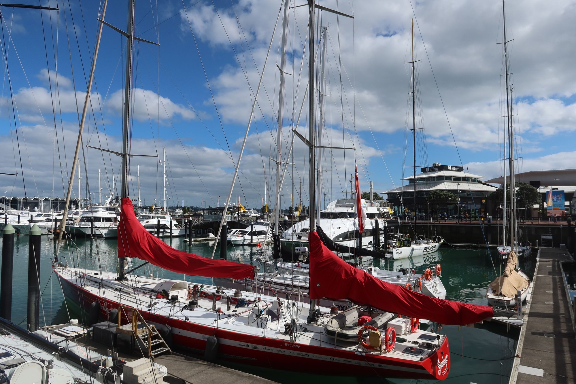
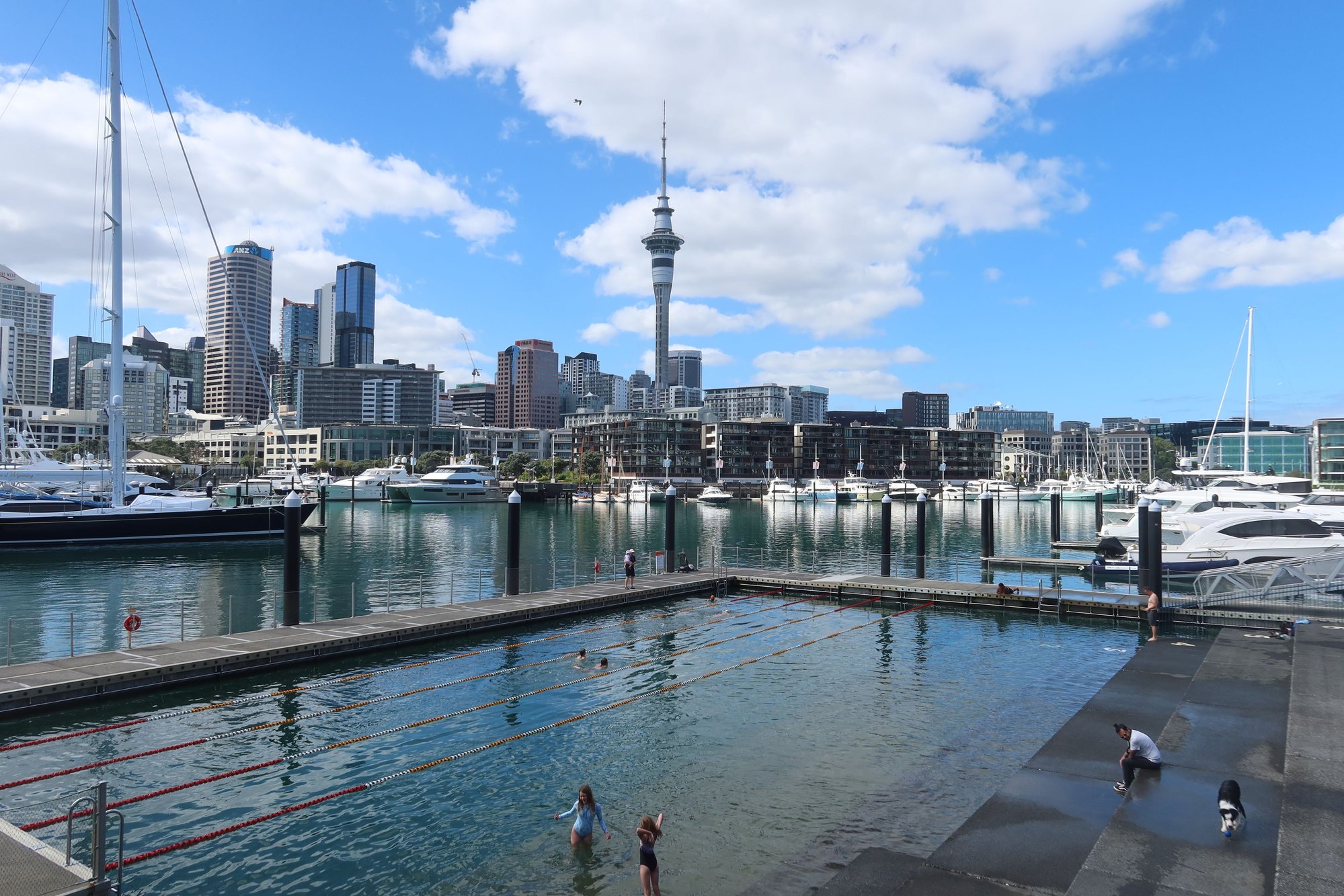
It was a glorious day today in New Zealand’s largest city – about 70 degrees Fahrenheit and the sun shining brightly. We spent the first couple hours of our second visit to Auckland strolling around Viaduct Harbor, home to shops, restaurants, and cafes. We walked along the promenade encircling the harbor with its sailboats bobbing in the glistening blue waters. It is so nice to be back!
At the harbor is the worthwhile New Zealand Maritime Museum. We spent about an hour and a half viewing its exhibits, which told the tales of the Polynesian migration across the Pacific and eventually to New Zealand, European exploration, and successive waves of immigration to this island nation. Also on display are yachts from New Zealand’s participation in successive America’s Cup races, showcasing the country’s prowess on the waters.
We then wandered over to the Britomart precinct, where we ate a light lunch of pizzas at The Brit Pub and Eatery (we recommend it for a quick and tasty bite, especially if you’re looking for something light as we were), did some shopping along Queen Street, and enjoyed some coffee while watching people go by. New Zealand sure has some excellent coffee.
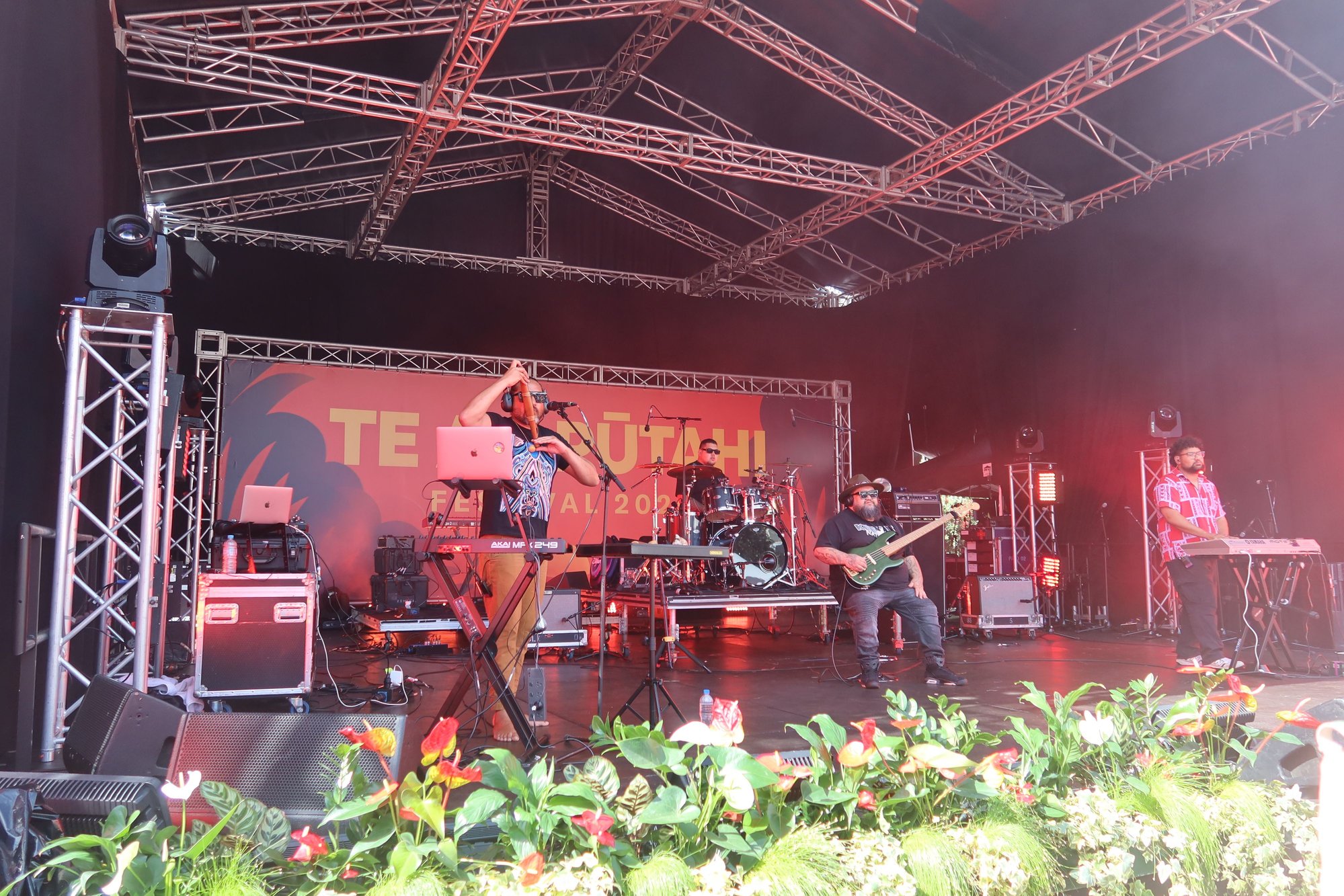
We made our way down to Aotea Square, where we happened upon an indigenous festival taking place. Today is the first day of the weeklong festival. There were tents selling Maori and other ware from neighboring Polynesian islands, Polynesian food, and best of all live Maori music. We spend some time listening to the music and enjoying the atmosphere overall.
From Aotea Square we strolled west, to Ponsonby, a street lined with nice shops, restaurants, and cafes. We weren’t looking for any particular store, but more interested in just enjoying the city and getting some additional steps in. We ate dinner at Azabu, a Japanese restaurant, on Ponsonby, where we dined on sashimi, rolls, tempura, and a couple other items. We capped our evening with gelatos from Island Gelato Company, a Waiheke Island favorite that we enjoyed from our last visit, before walking back to Viaduct Harbor and our hotel, the Sebel.
All in all, we spent about 12 hours out and about in this beautiful harborside city today. It's so good to be back, even though it took us 12 years.
Viaduct Harbor
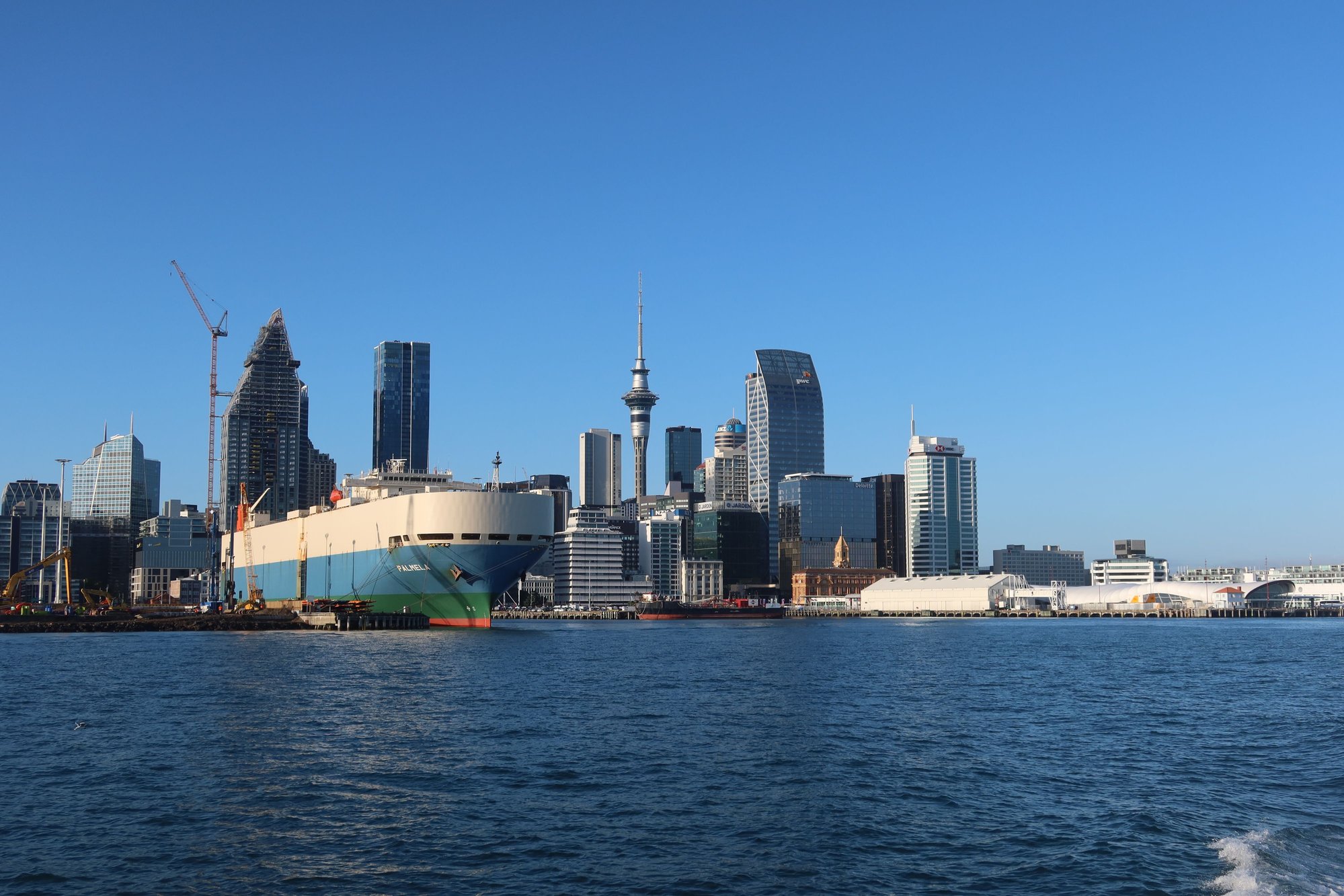
Auckland Skyline
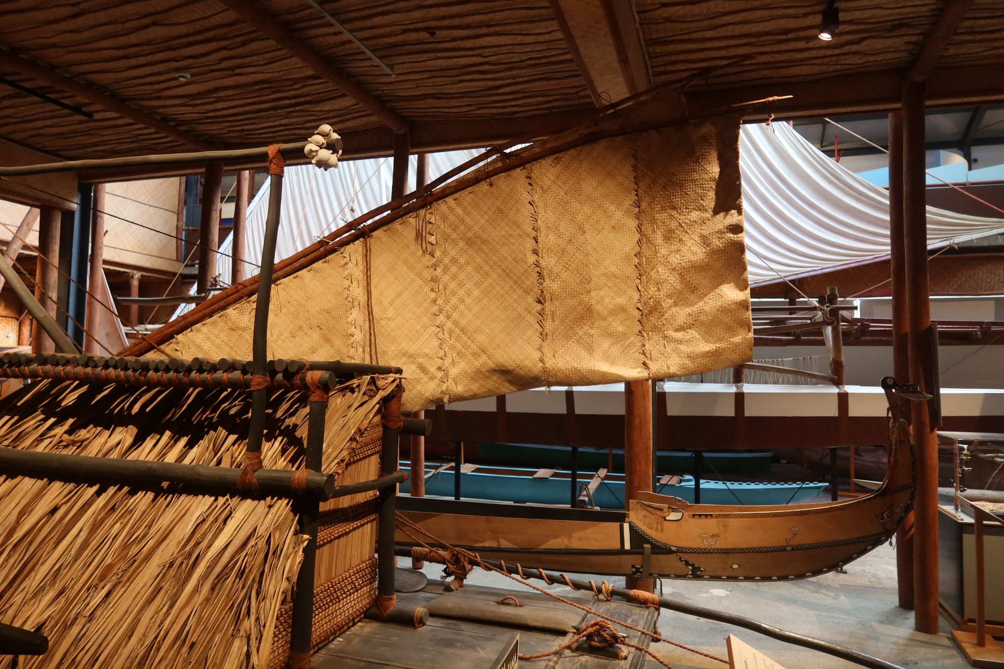
An Early Fijian Oceangoing Vessel
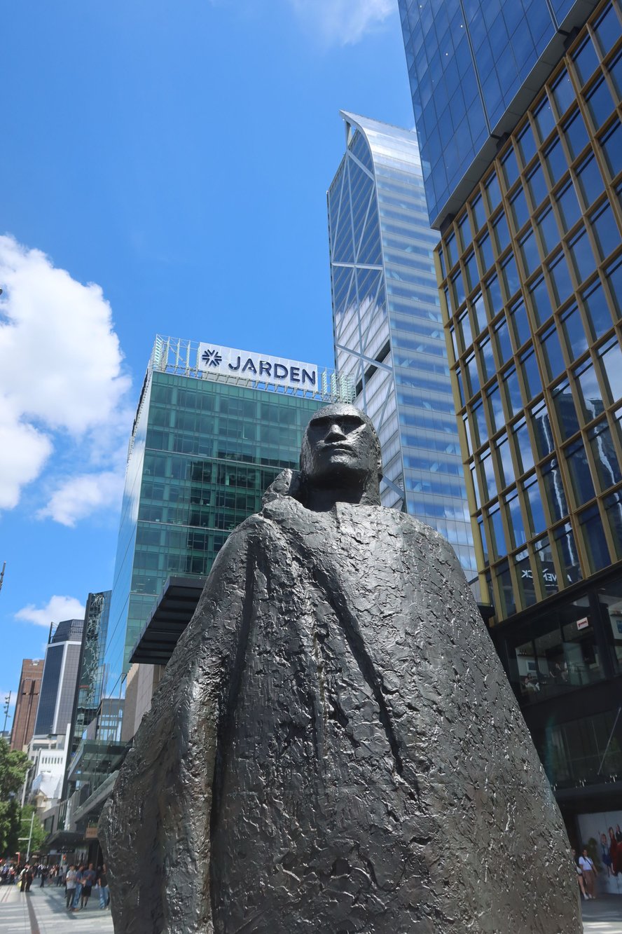
A Maori Chieftain across from Britomart Building

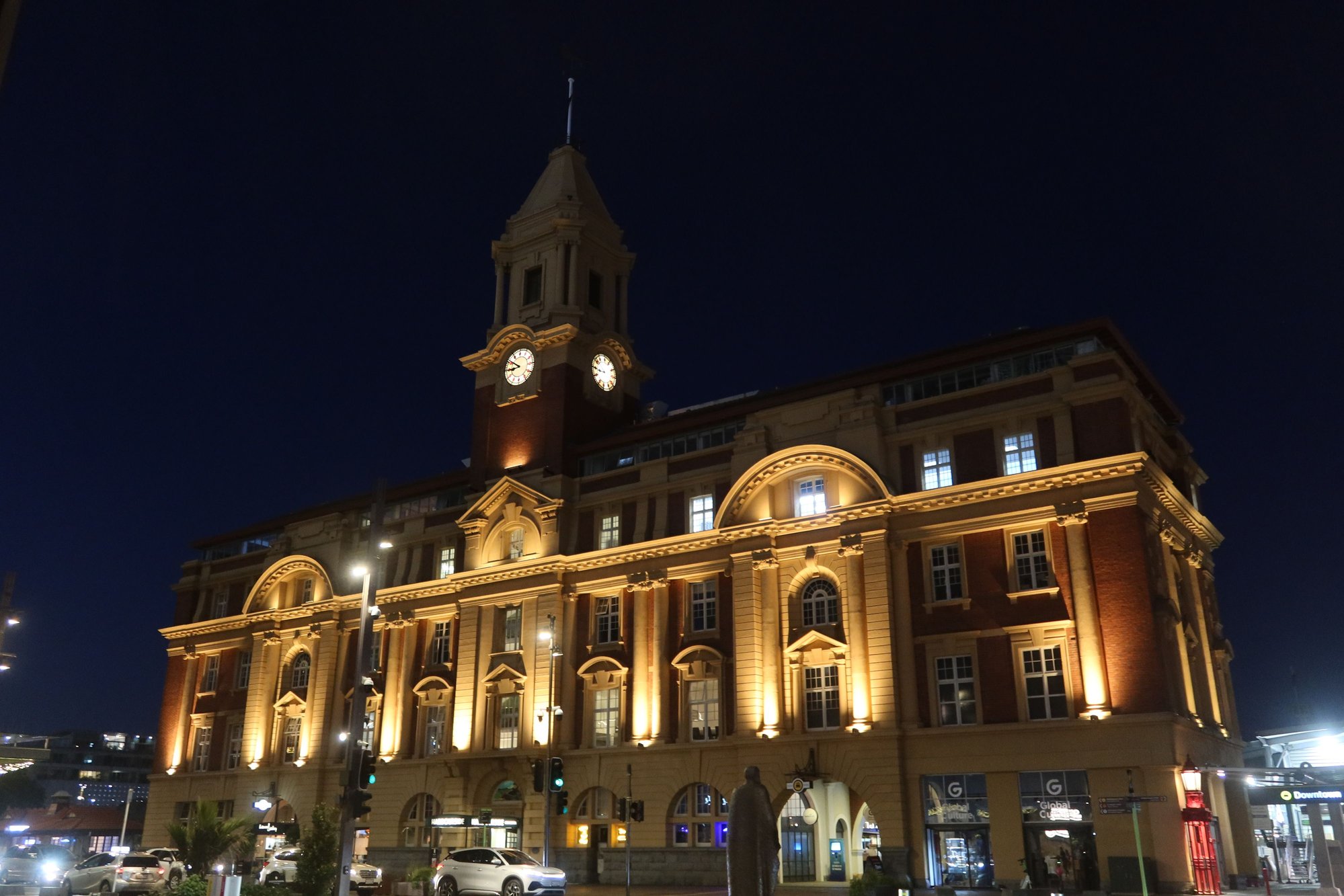
Auckland Town Hall
Maori Performers at Aotea Square
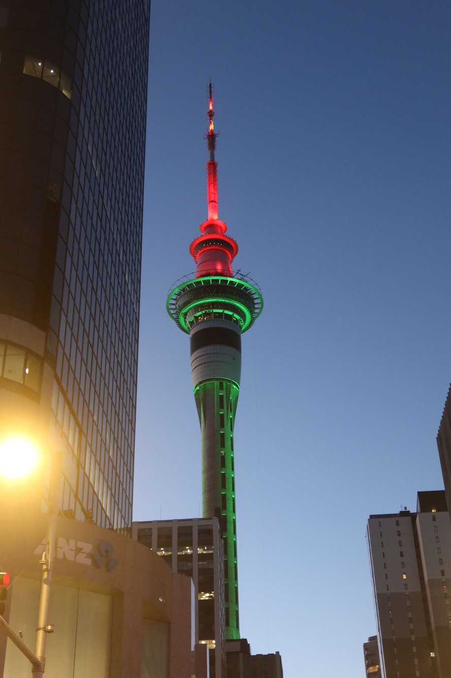
SkyCity in Christmas Lights
Britomart Building
We arrived in Auckland at 8:30 AM following a fairly easy but long 14.5-hour flight from Dallas. The airport was quiet in this early hour. Having already completed our customs declaration and with American passport holders welcome to use the e-gates at immigration, we were out of the airport in 10 minutes. We took a taxi from the airport to Viaduct Harbor, where our hotel is located, for NZ$99.
It was a glorious day today in New Zealand’s largest city – about 70 degrees Fahrenheit and the sun shining brightly. We spent the first couple hours of our second visit to Auckland strolling around Viaduct Harbor, home to shops, restaurants, and cafes. We walked along the promenade encircling the harbor with its sailboats bobbing in the glistening blue waters. It is so nice to be back!
At the harbor is the worthwhile New Zealand Maritime Museum. We spent about an hour and a half viewing its exhibits, which told the tales of the Polynesian migration across the Pacific and eventually to New Zealand, European exploration, and successive waves of immigration to this island nation. Also on display are yachts from New Zealand’s participation in successive America’s Cup races, showcasing the country’s prowess on the waters.
We then wandered over to the Britomart precinct, where we ate a light lunch of pizzas at The Brit Pub and Eatery (we recommend it for a quick and tasty bite, especially if you’re looking for something light as we were), did some shopping along Queen Street, and enjoyed some coffee while watching people go by. New Zealand sure has some excellent coffee.
We made our way down to Aotea Square, where we happened upon an indigenous festival taking place. Today is the first day of the weeklong festival. There were tents selling Maori and other ware from neighboring Polynesian islands, Polynesian food, and best of all live Maori music. We spend some time listening to the music and enjoying the atmosphere overall.
From Aotea Square we strolled west, to Ponsonby, a street lined with nice shops, restaurants, and cafes. We weren’t looking for any particular store, but more interested in just enjoying the city and getting some additional steps in. We ate dinner at Azabu, a Japanese restaurant, on Ponsonby, where we dined on sashimi, rolls, tempura, and a couple other items. We capped our evening with gelatos from Island Gelato Company, a Waiheke Island favorite that we enjoyed from our last visit, before walking back to Viaduct Harbor and our hotel, the Sebel.
All in all, we spent about 12 hours out and about in this beautiful harborside city today. It's so good to be back, even though it took us 12 years.
Viaduct Harbor
Auckland Skyline
An Early Fijian Oceangoing Vessel
A Maori Chieftain across from Britomart Building
Auckland Town Hall
Maori Performers at Aotea Square
SkyCity in Christmas Lights
Britomart Building
Nov 16th, 2025 | 11:43 PM
#5
Original Poster
Joined: Sep 2012
Posts: 3,567
Likes: 0
muntiga, I'm not sure I understand what you mean about a foot permit. We do not need permission for any of the hikes we're doing.
Heaven on Earth
If there is such a place as a heaven on earth, it could very well be Waiheke Island. Facing Auckland's central business district is a body of water called the Hauraki Gulf, which empties into the Pacific Ocean. Scattered among the Hauraki Gulf are multiple islands including Rangitoto Island with its rather symmetrical volcanic cone visible from parts of the city, Tiritiri Matangi Island with its unique birdlife, and Waiheke Island, one of the area's premier playgrounds.
Oh, Waiheke! Home to numerous hiking trails, inviting villages with all sorts of shops and cafes, wineries galore, and beautiful sandy beaches, our short but very memorable time on Waiheke Island stuck with us for the past twelve years. We knew that we had to go back to Waiheke as we would be in the Auckland area on this trip.
As rain is forecast for tomorrow, we made a last-minute decision to move up our day trip to Waiheke Island to today. This meant an early morning wakeup, with the goal of catching one of the first ferries to Waiheke Island. Ferries between Auckland and Waiheke Island run every 15-30 minutes. We chose an early departure so that we could do a half-day hike in the morning when it wasn't too hot and we could cap off our visit with a trip to one of the renown wineries on the island for tasting and lunch.
We caught the 7:15 AM ferry to Waiheke Island, arriving about 35-minutes later. We began our visit with what would be a 4-hour hike across the western part of the island. While there are many options to choose from, we stuck with part of the Te Ara Hura trail (aucklandcouncil.govt.nz/parks-recreation/get-outdoors/find-a-walk/Documents/te-ara-hura-map.pdf), which circles around the entire island in 5 days.
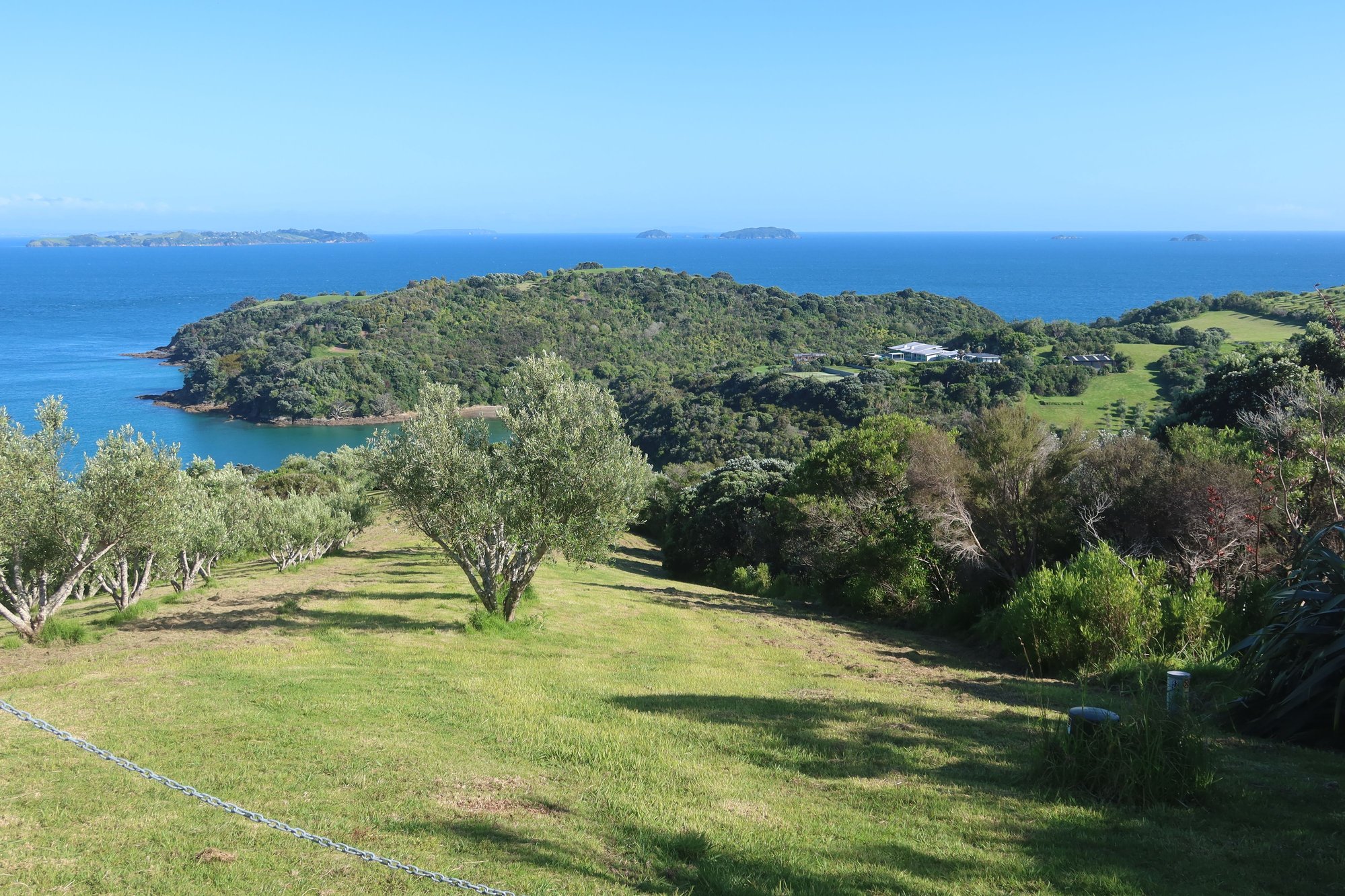
We chose the section from Matiatia Ferry Terminal to Palm Beach. Just down the road from the ferry terminal, we followed a path uphill. The ascent was an easy 15-minute walk of mostly steps and gravel paths. Towards the top we enjoyed gorgeous views of the hills across Waiheke Island, the blue waters beyond the island, and a Gulf that is dotted with numerous smaller islands and rock outcrops. As it was higher tide, we could not take the coastal path for large parts of the walk. There were also sections that were undergoing maintenance in advance of the summer crowds. Even though we were on pavement for large sections of the walk, we could not complain about the spectacular vistas. The signage was good, indicating where the paths are along with information about destinations and distances.
After a little more than an hour and a half, we reached Oneroa Beach (Matiatia to Oneroa – the Mokemoke Pā headland walk - Walk Waiheke), with the fine sand and the turquoise waters of the Gulf. We took a quick detour up to the village, where we enjoyed a coffee break and browsed some of the shops. There are not many places where you could break up your day hikes with refreshments, shopping, excellent food, and wines. Refreshed, we returned to the beach and continued onward, where we passed Little Oneroa Beach, nice homes, more secluded bays with sandy shores, and a forested valley. After about an hour and a half, we reached Palm Beach (Oneroa to Palm Beach - Walk Waiheke), yet another long stretch of fine sand. On the beach were interesting rock outcrops which seem left from past volcanic eruptions.
From Palm Beach, we took a taxi to Tantalus Estate, one of the many fine wineries on Waiheke Island. Tantalus is located in the central part of the island, on the southern side. Stonyridge is another fine winery within walking distance of Tantalus, but undergoing some renovations. Mudbrick and Cable Bay are two wineries closer to the ferry terminal that we enjoyed on our prior visit. Back to Tantalus, it is a small boutique winery that produces excellent red wines. We partook in a wine tasting of five different vintages before settling down for lunch in its restaurant patioverlooking the vines. If the wines were good, the food was even better. A couple of us ordered lamb while the other two ordered fish - it couldn't have been any better. We also enjoyed some snacks and cheeses, to go along with the oh-so-smooth wines.
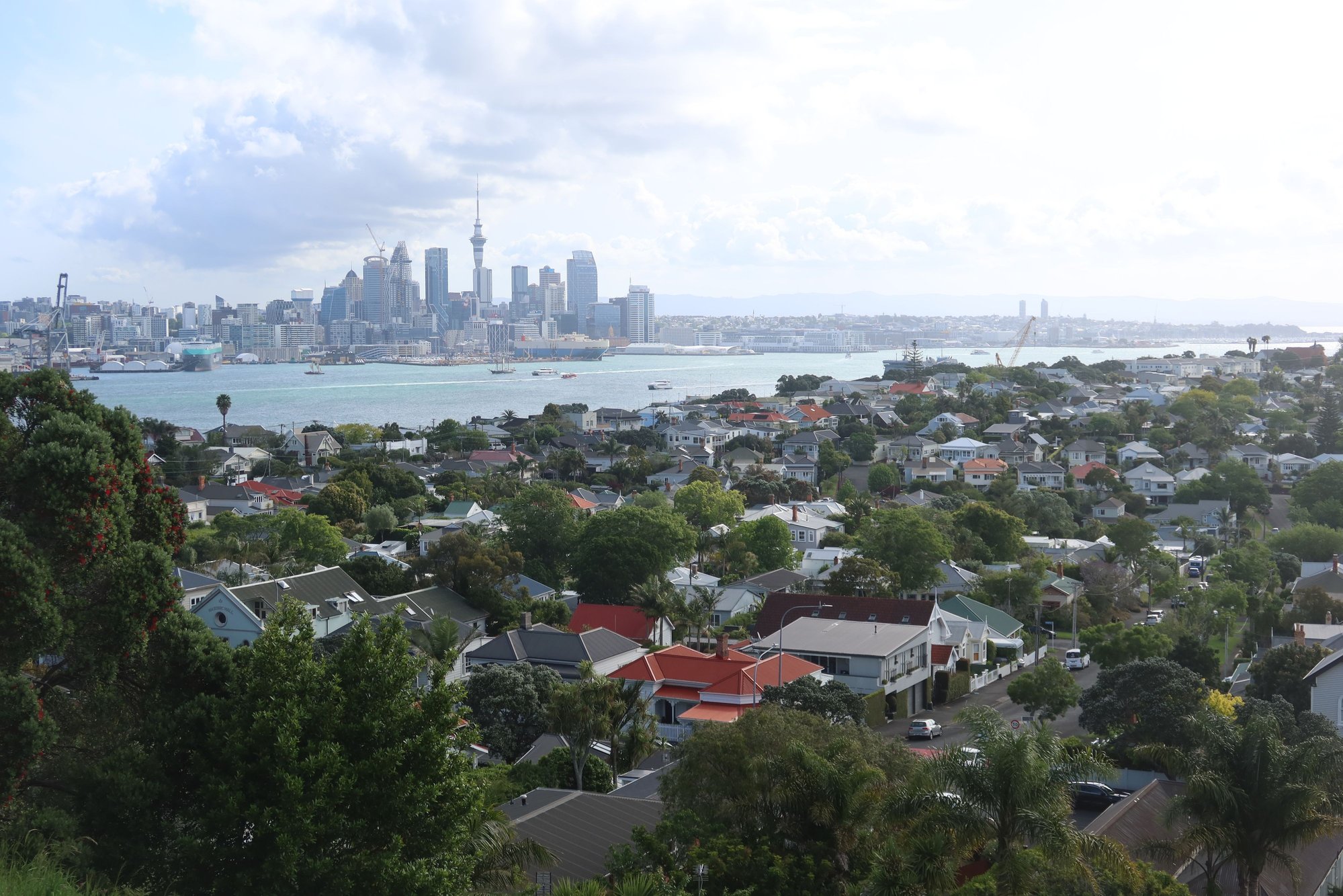
After 2.5 hours at Tantalus, we caught a public bus back to the ferry terminal. The bus runs every 20 or so minutes and takes credit and debit cards in addition to paying from a transit card or an app. We caught a 4:00 PM ferry back to Auckland. The ferry, however, made a stop in Devonport on the north shore of Waitemata Harbor on the way back to Auckland. As it was still early, we thought why not. Devonport was a neighborhood we very much enjoyed on our prior visit to Auckland, so we decided to hop off the ferry here. At Devonport, we hiked up to the summit of Mount Victoria with its blockbuster views of Auckland and some of the islands we sailed by earlier today. The waterfront promenade was also nice, with beautiful homes facing the water and ferries coming and going.
As we ate a later lunch, we chose to eat a light dinner, at Devon on the Wharf, right at the ferry terminal. We settled on some appetizers and a couple of pizzas, which did the trick. From Devonport, it's an easy 15-minute ferry ride back to downtown Auckland.
What an incredible day today was. All the great feelings we had about Waiheke Island were reconfirmed today. Perhaps one day we could camp down on Waiheke a little longer.
Auckland Skyline from the Ferry

Cranes at Auckland Port

Rangitoto Island
View from Beginning Section of Te Ara Hura Trail

Oneroa Beach

Hekerua Bay

Volcanic Rocks at Palm Beach

Vines at Tantalus Estate

Historic Devonport Hotel
Auckland from Mount Victoria
Heaven on Earth
If there is such a place as a heaven on earth, it could very well be Waiheke Island. Facing Auckland's central business district is a body of water called the Hauraki Gulf, which empties into the Pacific Ocean. Scattered among the Hauraki Gulf are multiple islands including Rangitoto Island with its rather symmetrical volcanic cone visible from parts of the city, Tiritiri Matangi Island with its unique birdlife, and Waiheke Island, one of the area's premier playgrounds.
Oh, Waiheke! Home to numerous hiking trails, inviting villages with all sorts of shops and cafes, wineries galore, and beautiful sandy beaches, our short but very memorable time on Waiheke Island stuck with us for the past twelve years. We knew that we had to go back to Waiheke as we would be in the Auckland area on this trip.
As rain is forecast for tomorrow, we made a last-minute decision to move up our day trip to Waiheke Island to today. This meant an early morning wakeup, with the goal of catching one of the first ferries to Waiheke Island. Ferries between Auckland and Waiheke Island run every 15-30 minutes. We chose an early departure so that we could do a half-day hike in the morning when it wasn't too hot and we could cap off our visit with a trip to one of the renown wineries on the island for tasting and lunch.
We caught the 7:15 AM ferry to Waiheke Island, arriving about 35-minutes later. We began our visit with what would be a 4-hour hike across the western part of the island. While there are many options to choose from, we stuck with part of the Te Ara Hura trail (aucklandcouncil.govt.nz/parks-recreation/get-outdoors/find-a-walk/Documents/te-ara-hura-map.pdf), which circles around the entire island in 5 days.
We chose the section from Matiatia Ferry Terminal to Palm Beach. Just down the road from the ferry terminal, we followed a path uphill. The ascent was an easy 15-minute walk of mostly steps and gravel paths. Towards the top we enjoyed gorgeous views of the hills across Waiheke Island, the blue waters beyond the island, and a Gulf that is dotted with numerous smaller islands and rock outcrops. As it was higher tide, we could not take the coastal path for large parts of the walk. There were also sections that were undergoing maintenance in advance of the summer crowds. Even though we were on pavement for large sections of the walk, we could not complain about the spectacular vistas. The signage was good, indicating where the paths are along with information about destinations and distances.
After a little more than an hour and a half, we reached Oneroa Beach (Matiatia to Oneroa – the Mokemoke Pā headland walk - Walk Waiheke), with the fine sand and the turquoise waters of the Gulf. We took a quick detour up to the village, where we enjoyed a coffee break and browsed some of the shops. There are not many places where you could break up your day hikes with refreshments, shopping, excellent food, and wines. Refreshed, we returned to the beach and continued onward, where we passed Little Oneroa Beach, nice homes, more secluded bays with sandy shores, and a forested valley. After about an hour and a half, we reached Palm Beach (Oneroa to Palm Beach - Walk Waiheke), yet another long stretch of fine sand. On the beach were interesting rock outcrops which seem left from past volcanic eruptions.
From Palm Beach, we took a taxi to Tantalus Estate, one of the many fine wineries on Waiheke Island. Tantalus is located in the central part of the island, on the southern side. Stonyridge is another fine winery within walking distance of Tantalus, but undergoing some renovations. Mudbrick and Cable Bay are two wineries closer to the ferry terminal that we enjoyed on our prior visit. Back to Tantalus, it is a small boutique winery that produces excellent red wines. We partook in a wine tasting of five different vintages before settling down for lunch in its restaurant patioverlooking the vines. If the wines were good, the food was even better. A couple of us ordered lamb while the other two ordered fish - it couldn't have been any better. We also enjoyed some snacks and cheeses, to go along with the oh-so-smooth wines.
After 2.5 hours at Tantalus, we caught a public bus back to the ferry terminal. The bus runs every 20 or so minutes and takes credit and debit cards in addition to paying from a transit card or an app. We caught a 4:00 PM ferry back to Auckland. The ferry, however, made a stop in Devonport on the north shore of Waitemata Harbor on the way back to Auckland. As it was still early, we thought why not. Devonport was a neighborhood we very much enjoyed on our prior visit to Auckland, so we decided to hop off the ferry here. At Devonport, we hiked up to the summit of Mount Victoria with its blockbuster views of Auckland and some of the islands we sailed by earlier today. The waterfront promenade was also nice, with beautiful homes facing the water and ferries coming and going.
As we ate a later lunch, we chose to eat a light dinner, at Devon on the Wharf, right at the ferry terminal. We settled on some appetizers and a couple of pizzas, which did the trick. From Devonport, it's an easy 15-minute ferry ride back to downtown Auckland.
What an incredible day today was. All the great feelings we had about Waiheke Island were reconfirmed today. Perhaps one day we could camp down on Waiheke a little longer.
Auckland Skyline from the Ferry
Cranes at Auckland Port
Rangitoto Island
View from Beginning Section of Te Ara Hura Trail
Oneroa Beach
Hekerua Bay
Volcanic Rocks at Palm Beach
Vines at Tantalus Estate
Historic Devonport Hotel
Auckland from Mount Victoria
Nov 18th, 2025 | 02:04 AM
#6
Original Poster
Joined: Sep 2012
Posts: 3,567
Likes: 0
Atop a Field of Volcanoes
The Auckland region, pretty much all of New Zealand as a whole, was formed by multiple undersea volcanoes that erupted tens of millions of years ago and rose to the surface. Within the Auckland area are somewhere between 48 and 52 volcanoes. One could easily spot about a dozen by doing a scan of the landscape from a high point.
Volcanoes were a feature of today's tramp (New Zealander term for hiking) across the City of Auckland. We traversed the length of Auckland, strung together by the Coast to Coast Walkway, 16 kilometer trail signposted throughout the way. The walk began in the southern community of Onehunga and the shores of Manukau Harbor, where we enjoyed views of a volcano across the water and mountains in the distance. To reach Onehunga, we took the train from Waitemata station downtown. The ride, including a transfer, took about an hour.
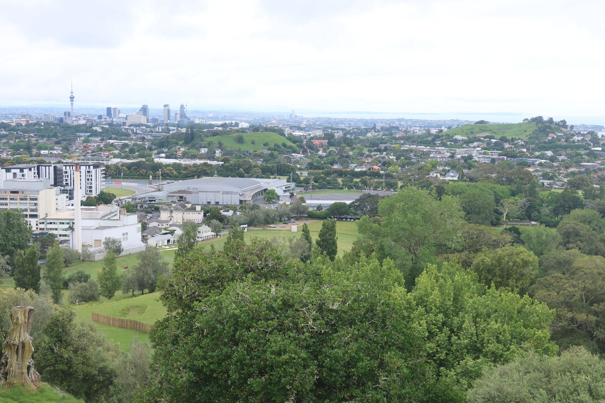
From here we passed numerous homes, including a large collection of Victorian residences, before we reached One Tree Hill, a volcano with a monument at the top honoring Maori who defended their homeland and carried on their traditions. The 360 degree views are stunning. We saw the city skyline, homes as far as the eyes can see, both Manukau and Waitemata Harbors, and numerous volcanoes.
From One Tree Hill, we continued on to Cornwall Park immediately to the north. Here we visited Acacia Cottage, believed to be the first European residence in the city, and sheep and cow grazing the tender shoots of grass. Speaking of grazing, we did some of our own af the excellent bistro inside the park. There were lots of great options, including breakfast all day. We aimed for a light meal of soups, salads, and pastas.
The intense humidity this morning gave way to showers in the afternoon. A gentle rain started to fall while we were eating lunch and followed us for the next part of our walk, again through a couple of neighborhoods. We soon reached Mt. Eden, the largest volcano in Auckland, along we spent about half an hour waiting out some heavier rain showers.
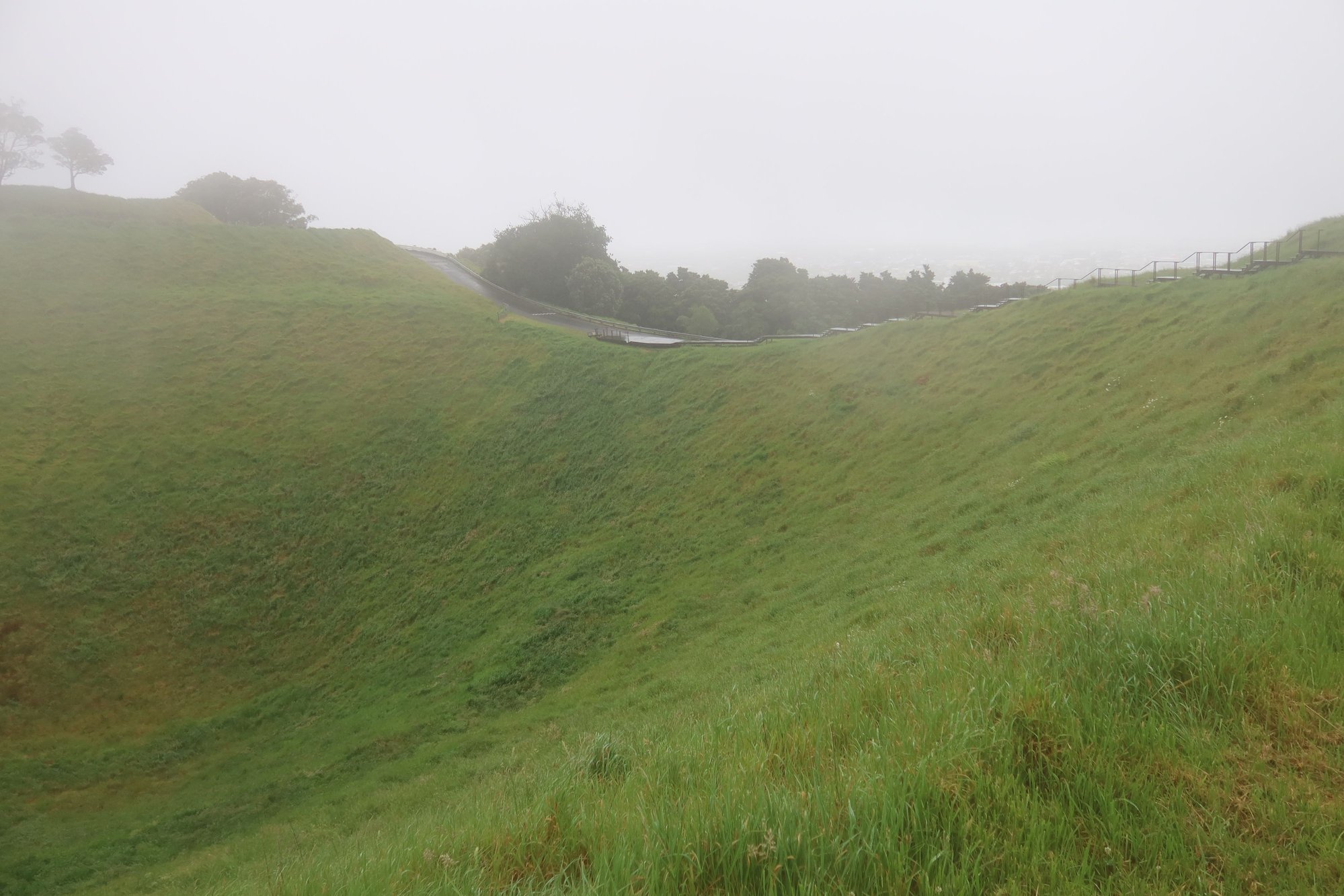
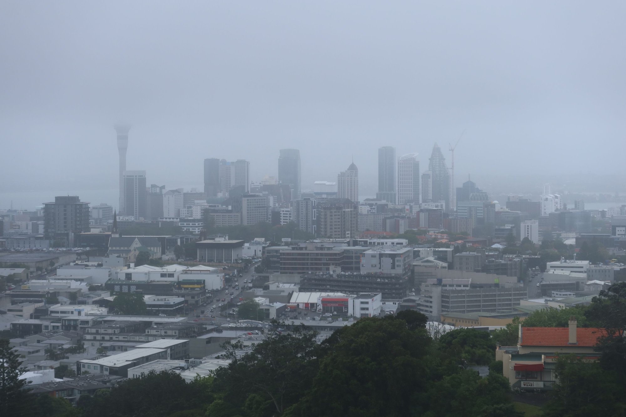
We ascended Mt. Eden as soon as the rain tapered although the more perfect views we enjoyed earlier this morning at One Tree Hill were not to be had. A fog hung over the city, obscuring what would have been excellent views. We were able to make out some of the volcanoes and buildings below us through the mist. At the top of the summit is a huge crater. We circumnavigated the Crater, although the views of the city below were impossible. We could see the taller buildings downtown through the fog. Sky City played peek-a-boo with us; we didn't mind seeing it through the fog.
We continued along the Coast to Coast Walkway to the Domain, one of the city's largest urban parks. Two major attractions at the Domain are the Wintergardens and the Auckland War Memorial Museum. We took a quick look at the gardens, which houses two greenhouses and a fernery (ferns are a symbol of New Zealand). We spent about two hours at the museum, although we were disappointed that our two favorites galleries - the one on Maori life and the one about Pacific island cultures - were closed for renovations. We didn't really care for the exhibits on war history but quite enjoyed the one dedicated to Maori mythology including of creation of the world. Also worthwhile were the ones about Auckland's volcanic landscape and life in the area.
Unfortunately the rain picked up again by the time we left. We waited for it to subside a bit and then continued our way along the Coast to Coast. By now we were fully in downtown Auckland. We walked through the main campus of the University of Auckland and along some of the major thoroughfares of the central business district. We completed our walk at the Britomart Ferry Building and Viaduct Harbor.
We were wet but felt accomplished. The route provided us with a good look at the city and its geological features that we may not have otherwise been able to appreciate. The foundation of Auckland is in reality a field of volcanoes; the city just sits on top of it.
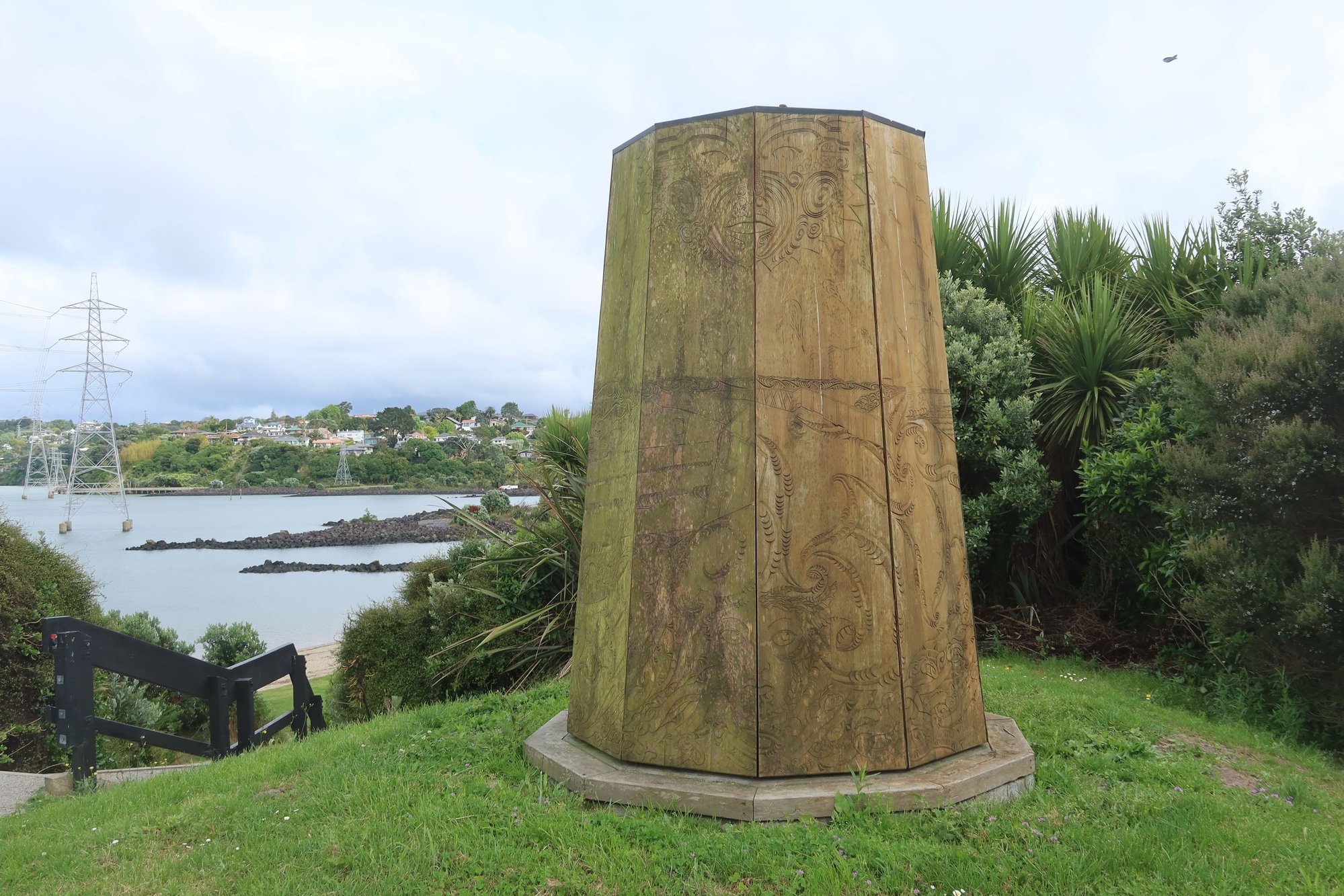
Maori Marker at Manuhau Harbor, Start of the Coast to Coast Walkway

View across Manuhau Harbor

Historic Home in Jellicoe Park
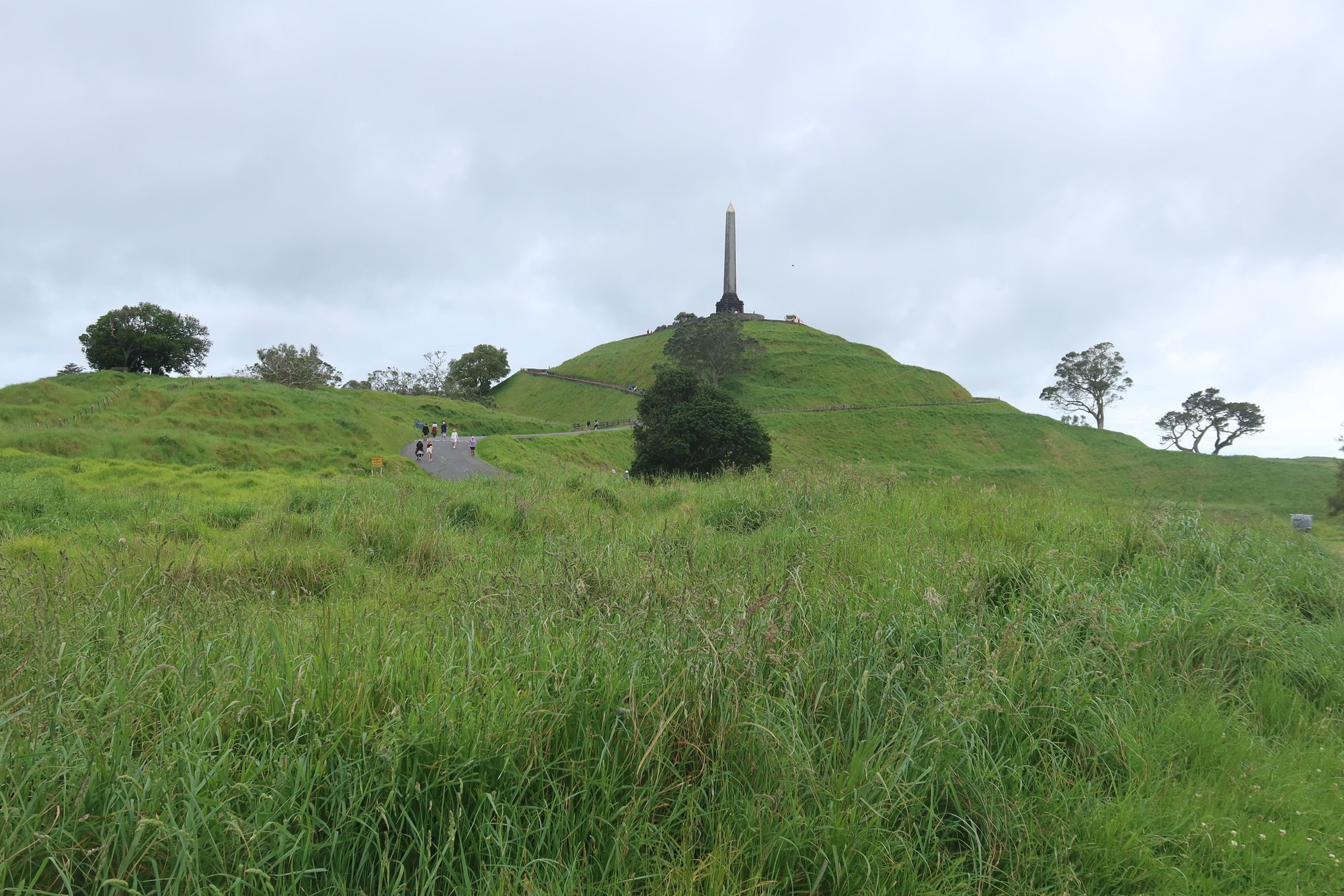
One Tree Hill
City from One Tree Hill

Rangitoto from One Tree Hill

Sheep in Cornwall Park
Crater atop Mt. Eden
City Skyline in the Fog from Mt. Eden

Wintergardens
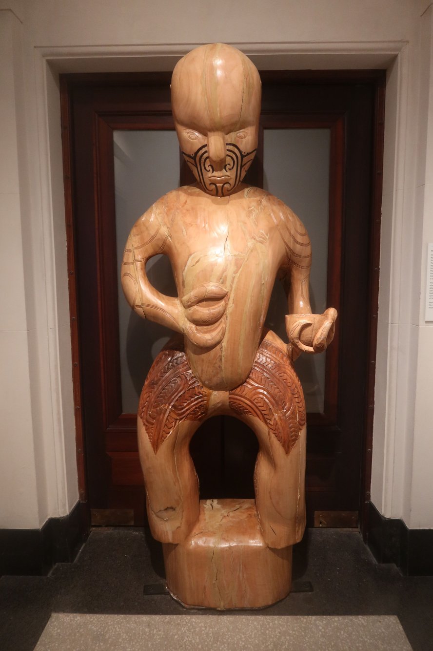
Maori Statue in Remembrance of Fallen Soldiers at Auckland War Memorial Museum

Christmas Tree being Assembled in Front of Britomart Ferry Building, End of Coast to Coast Walkway
The Auckland region, pretty much all of New Zealand as a whole, was formed by multiple undersea volcanoes that erupted tens of millions of years ago and rose to the surface. Within the Auckland area are somewhere between 48 and 52 volcanoes. One could easily spot about a dozen by doing a scan of the landscape from a high point.
Volcanoes were a feature of today's tramp (New Zealander term for hiking) across the City of Auckland. We traversed the length of Auckland, strung together by the Coast to Coast Walkway, 16 kilometer trail signposted throughout the way. The walk began in the southern community of Onehunga and the shores of Manukau Harbor, where we enjoyed views of a volcano across the water and mountains in the distance. To reach Onehunga, we took the train from Waitemata station downtown. The ride, including a transfer, took about an hour.
From here we passed numerous homes, including a large collection of Victorian residences, before we reached One Tree Hill, a volcano with a monument at the top honoring Maori who defended their homeland and carried on their traditions. The 360 degree views are stunning. We saw the city skyline, homes as far as the eyes can see, both Manukau and Waitemata Harbors, and numerous volcanoes.
From One Tree Hill, we continued on to Cornwall Park immediately to the north. Here we visited Acacia Cottage, believed to be the first European residence in the city, and sheep and cow grazing the tender shoots of grass. Speaking of grazing, we did some of our own af the excellent bistro inside the park. There were lots of great options, including breakfast all day. We aimed for a light meal of soups, salads, and pastas.
The intense humidity this morning gave way to showers in the afternoon. A gentle rain started to fall while we were eating lunch and followed us for the next part of our walk, again through a couple of neighborhoods. We soon reached Mt. Eden, the largest volcano in Auckland, along we spent about half an hour waiting out some heavier rain showers.
We ascended Mt. Eden as soon as the rain tapered although the more perfect views we enjoyed earlier this morning at One Tree Hill were not to be had. A fog hung over the city, obscuring what would have been excellent views. We were able to make out some of the volcanoes and buildings below us through the mist. At the top of the summit is a huge crater. We circumnavigated the Crater, although the views of the city below were impossible. We could see the taller buildings downtown through the fog. Sky City played peek-a-boo with us; we didn't mind seeing it through the fog.
We continued along the Coast to Coast Walkway to the Domain, one of the city's largest urban parks. Two major attractions at the Domain are the Wintergardens and the Auckland War Memorial Museum. We took a quick look at the gardens, which houses two greenhouses and a fernery (ferns are a symbol of New Zealand). We spent about two hours at the museum, although we were disappointed that our two favorites galleries - the one on Maori life and the one about Pacific island cultures - were closed for renovations. We didn't really care for the exhibits on war history but quite enjoyed the one dedicated to Maori mythology including of creation of the world. Also worthwhile were the ones about Auckland's volcanic landscape and life in the area.
Unfortunately the rain picked up again by the time we left. We waited for it to subside a bit and then continued our way along the Coast to Coast. By now we were fully in downtown Auckland. We walked through the main campus of the University of Auckland and along some of the major thoroughfares of the central business district. We completed our walk at the Britomart Ferry Building and Viaduct Harbor.
We were wet but felt accomplished. The route provided us with a good look at the city and its geological features that we may not have otherwise been able to appreciate. The foundation of Auckland is in reality a field of volcanoes; the city just sits on top of it.
Maori Marker at Manuhau Harbor, Start of the Coast to Coast Walkway
View across Manuhau Harbor
Historic Home in Jellicoe Park
One Tree Hill
City from One Tree Hill
Rangitoto from One Tree Hill
Sheep in Cornwall Park
Crater atop Mt. Eden
City Skyline in the Fog from Mt. Eden
Wintergardens
Maori Statue in Remembrance of Fallen Soldiers at Auckland War Memorial Museum
Christmas Tree being Assembled in Front of Britomart Ferry Building, End of Coast to Coast Walkway
Nov 18th, 2025 | 07:37 AM
#7
Joined: Mar 2025
Posts: 273
Likes: 0
Great trip report tripplanner. Looking forward to reading more.
Love the walking in NZ. The Kiwis , more than any other country in the world are so geared up for those tourists who want to explore on foot. The Department of Conservation make it very easy to explore on foot with all the well marked, well maintained trails.
We have taken several long trips exploring the country by campervan, but always in winter/spring when we often had most places to ourselves. Do you find it very crowded in summer time? A return trip may well be on the cards for early 2027 when we head down to see our Aussie family in Sydney.
Trending Topics
Nov 18th, 2025 | 09:13 PM
#8
Joined: Nov 2025
Posts: 4
Likes: 0
Hi there, I live in Auckland and have been reading your report with interest. It�s always nice to hear your homeland talked about glowingly.
my reason for writing is to make sure you�re aware of the recent devastating fire on the Tongariro Crossing. It was so shocking to see the damage all over the news. I tried to attach the latest update from the Department of Conservation but don�t have enough posts yet to add attachments.
Regards J
my reason for writing is to make sure you�re aware of the recent devastating fire on the Tongariro Crossing. It was so shocking to see the damage all over the news. I tried to attach the latest update from the Department of Conservation but don�t have enough posts yet to add attachments.
Regards J
Nov 18th, 2025 | 11:35 PM
#9
Original Poster
Joined: Sep 2012
Posts: 3,567
Likes: 0
Catch23, thank you. I haven't found places to be particularly crowded so far, at least in Auckland. There was a stream stream of visitors at Waitomo Caves and at Hobbiton today, including tour groups, but nothing like the crowds in Sydney in the summer. We're coming across a lot of independent travelers from Australia and tour groups from mainland China. I'm with you on the excellent information provided by the Department of Conservation.
Our Road Trip Begins
We awoke to a wet morning in Auckland. The rain from yesterday continued to come down, alternating between heavy and light. Even though we would happily enjoy more time, it was time to leave the City of Sails behind and start our journey travelling south the North Island - destination: Rotorua.
Our driver greeted us at our hotel lobby promptly at 7:30 AM, and into the van we went. We travelled south on State Highway 1, one of the main thoroughfares that connected the northern tip of the North Island to the southern tip of the South Island, spanning the entire length of the country. Exiting Auckland, we drove through Waikato, passing rolling green hills, homes, and industrial facilities. The Waikato is home to both industry and agriculture, and plays a significant role in New Zealand's economy. For this reason, it is one of the most densely populated parts of the country.
Our destination this morning was the Waitomo Caves, south of the city of Hamilton. The Waitomo Caves is a well-known underground cave system in New Zealand and firmly on the country's tourist circuit. In addition to limestone formations, the caves are home to a large colony of glowworms. There are four stages to the life of a glowworm - egg, larva, cocoon, and adult fly. The glowworms emit light in thr larva stage of their lives. The light, secreted from their bodies, attracts insects, their source of food. Situated on the banks of the Waitomo River, the glowworms cling to the ceiling of the caves and along the riverbanks. The 45-minute guided tour took us into the limestone caves on foot followed by a short ride along one of the waterways inside the cave where we saw hundreds if not thousands of glowworms overhead. The caves are not among the most interesting we've visited (Paradise and Phong Nha Caves in Vietnam take the cake on this score) and the boat ride was somewhat ho-hum. What makes the Waitomo Caves unique are the glowworms, if nothing else for its novelty. It's one of those once-is-enough attractions, especially given the distance to reach it (Waitomo is 2.5 hours from Auckland and 2 hours to Rotorua; it's about midway between Auckland and Tongariro National Park if you're travelling between the two points).
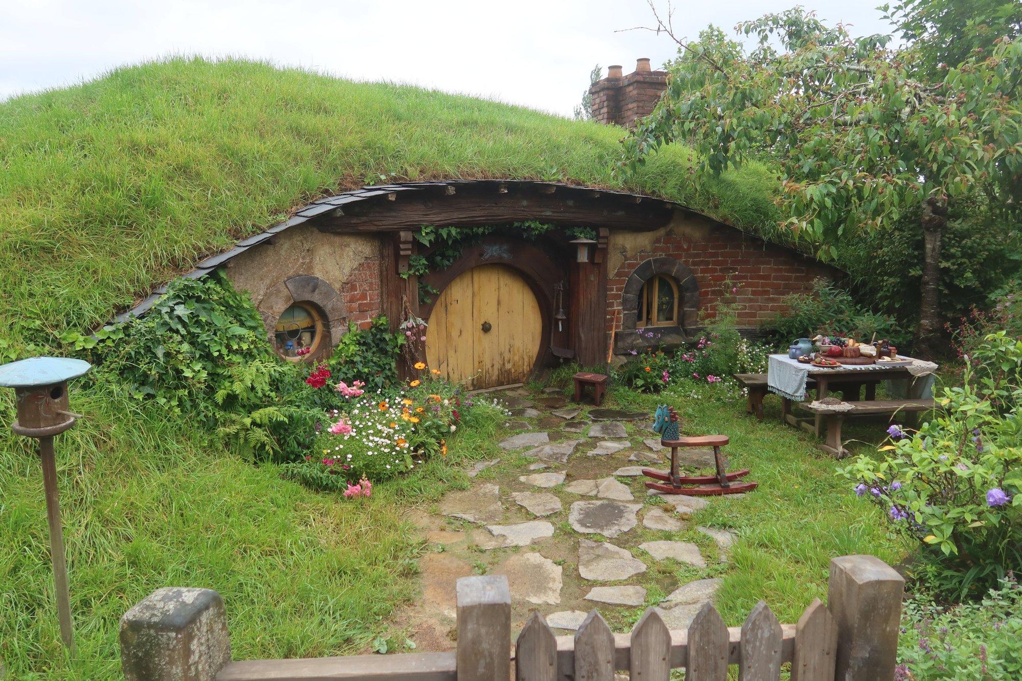
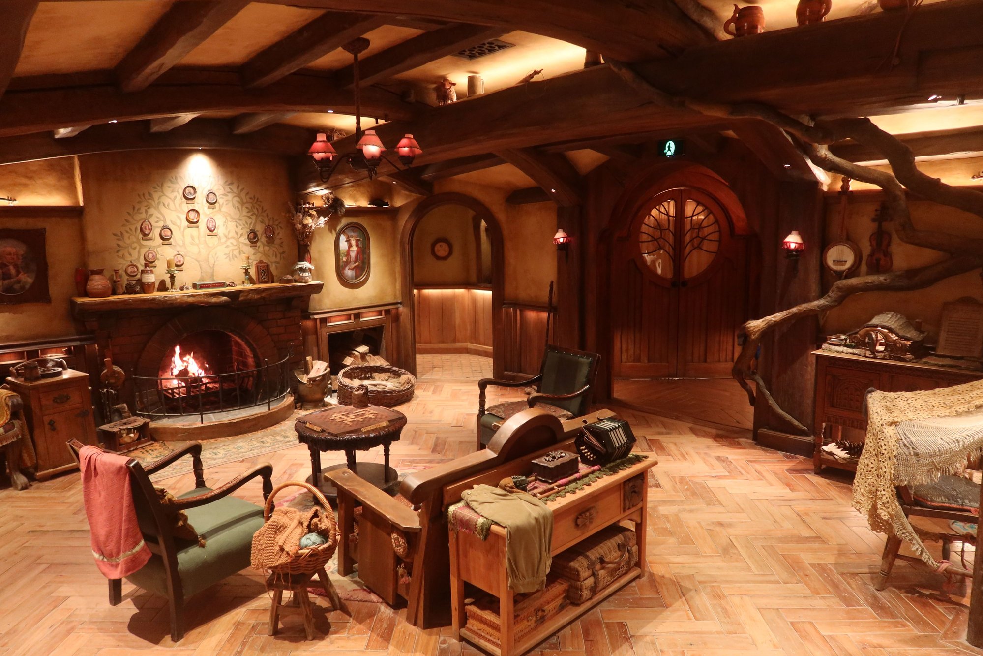
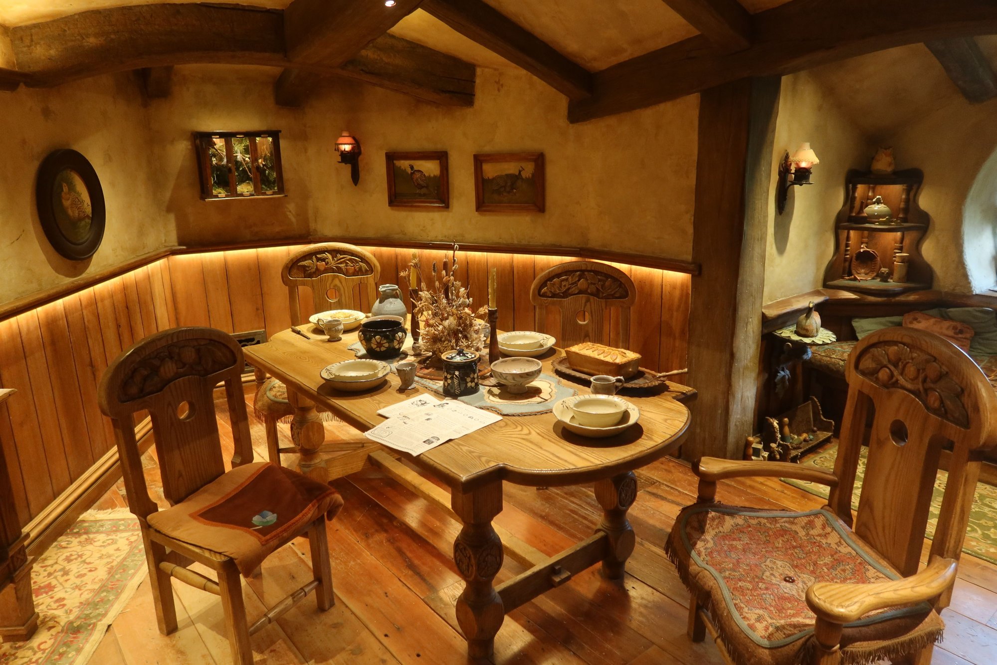
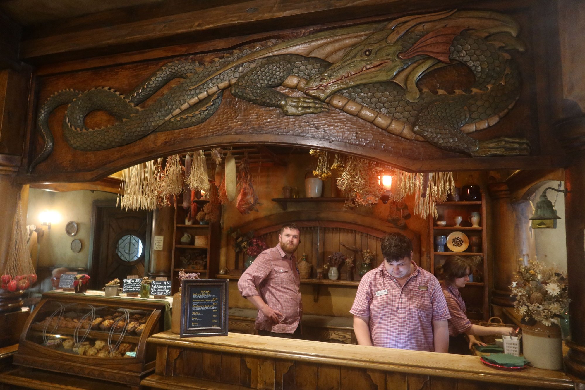
From Waitomo, we headed 1.5 hours east, to Matamata, home of Hobbiton, the movie set for The Shire of The Hobbit and Lord of the Rings fame. Hobbiton offers guided tours of The Shire every 10 minutes; even so, seats sell out well in advance. The 2.5-hour tour begins with a motorcoach ride to the movie set, passing the rolling pastures of the sheep and beef farm on which The Shire sits. The tour of the movie set is on foot. We walked around the Hobbit Holes including Bag End, visited a replica of the inside of one of the holes, and took lots of photographs. We had a very entertaining guide. At the end of the tour was a stop at the Green Dragon Inn for a complimentary pint of beer. The experience exceeded all of our expectations.
From Hobbiton it was a short one-hour trip to Rotorua, our home for the next three nights.

Waitomo Cave

Hobbit Holes, Hobbiton
Hobbit Hole, Hobbiton
Living Room Inside Hobbit Hole, Hobbiton
Dining Room Inside Hobbit Hole, Hobbiton
Bar at Green Dragon Inn, Hobbiton
Our Road Trip Begins
We awoke to a wet morning in Auckland. The rain from yesterday continued to come down, alternating between heavy and light. Even though we would happily enjoy more time, it was time to leave the City of Sails behind and start our journey travelling south the North Island - destination: Rotorua.
Our driver greeted us at our hotel lobby promptly at 7:30 AM, and into the van we went. We travelled south on State Highway 1, one of the main thoroughfares that connected the northern tip of the North Island to the southern tip of the South Island, spanning the entire length of the country. Exiting Auckland, we drove through Waikato, passing rolling green hills, homes, and industrial facilities. The Waikato is home to both industry and agriculture, and plays a significant role in New Zealand's economy. For this reason, it is one of the most densely populated parts of the country.
Our destination this morning was the Waitomo Caves, south of the city of Hamilton. The Waitomo Caves is a well-known underground cave system in New Zealand and firmly on the country's tourist circuit. In addition to limestone formations, the caves are home to a large colony of glowworms. There are four stages to the life of a glowworm - egg, larva, cocoon, and adult fly. The glowworms emit light in thr larva stage of their lives. The light, secreted from their bodies, attracts insects, their source of food. Situated on the banks of the Waitomo River, the glowworms cling to the ceiling of the caves and along the riverbanks. The 45-minute guided tour took us into the limestone caves on foot followed by a short ride along one of the waterways inside the cave where we saw hundreds if not thousands of glowworms overhead. The caves are not among the most interesting we've visited (Paradise and Phong Nha Caves in Vietnam take the cake on this score) and the boat ride was somewhat ho-hum. What makes the Waitomo Caves unique are the glowworms, if nothing else for its novelty. It's one of those once-is-enough attractions, especially given the distance to reach it (Waitomo is 2.5 hours from Auckland and 2 hours to Rotorua; it's about midway between Auckland and Tongariro National Park if you're travelling between the two points).
From Waitomo, we headed 1.5 hours east, to Matamata, home of Hobbiton, the movie set for The Shire of The Hobbit and Lord of the Rings fame. Hobbiton offers guided tours of The Shire every 10 minutes; even so, seats sell out well in advance. The 2.5-hour tour begins with a motorcoach ride to the movie set, passing the rolling pastures of the sheep and beef farm on which The Shire sits. The tour of the movie set is on foot. We walked around the Hobbit Holes including Bag End, visited a replica of the inside of one of the holes, and took lots of photographs. We had a very entertaining guide. At the end of the tour was a stop at the Green Dragon Inn for a complimentary pint of beer. The experience exceeded all of our expectations.
From Hobbiton it was a short one-hour trip to Rotorua, our home for the next three nights.
Waitomo Cave
Hobbit Holes, Hobbiton
Hobbit Hole, Hobbiton
Living Room Inside Hobbit Hole, Hobbiton
Dining Room Inside Hobbit Hole, Hobbiton
Bar at Green Dragon Inn, Hobbiton

 Nov 20th, 2025 | 10:57 AM
#11
Original Poster
Joined: Sep 2012
Posts: 3,567
Likes: 0
KarenWoo, the two islands are quite different but in our opinion equally worthwhile. We'll be visiting the Marlborough Sound area and Abel Tasman National Park, which I know you and Ed visited and enjoyed, later in this trip.
Crossroads of History, Culture, and Geology
Rotorua is a small city located in the north central part of the North Island of New Zealand. Located on the western shores of a lake by the same name, Rotorua sits on a hotbed of geological activity. The area is home to numerous geysers, steam vents, mud pools, and other geothermal features, sitting atop an active volcanic field. The smell of sulfur and steam coming out of the ground seemingly out of nowhere permeates Rotorua.
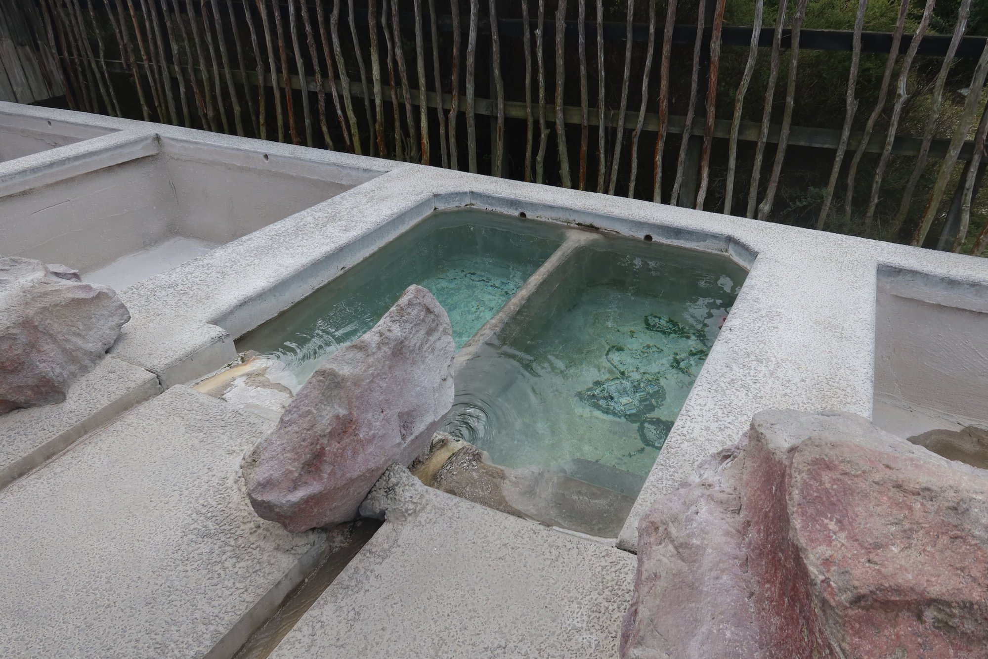
We spent the first morning walking around the city center, focused on outdoor attractions (the one major indoor attraction, the Rotorua Museum, is closed undergoing earthquake-proofing). We began across the street from our hotel, the Prince's Gate Hotel, at Government Gardens. A public park today, scattered throughout the Gardens are numerous former meeting places, bath houses, and spas.
We walked through the Gardens, past Rachel Spring (a hot spring), and skirted the Polynesian Spa for the access point to Rotorua's lakeside trail. Near this section of the trail is Sulphur Point, so named for the number of geothermal features such as bubbling rivers and streams, steam vents, and the like. From this section and throughout the walk are wonderful views of Lake Rotorua, the mountains to the east, and numerous birds as well as black swans, a city icon.The walk was not only scenic but incredibly peaceful, an almost perfect way to start the day.
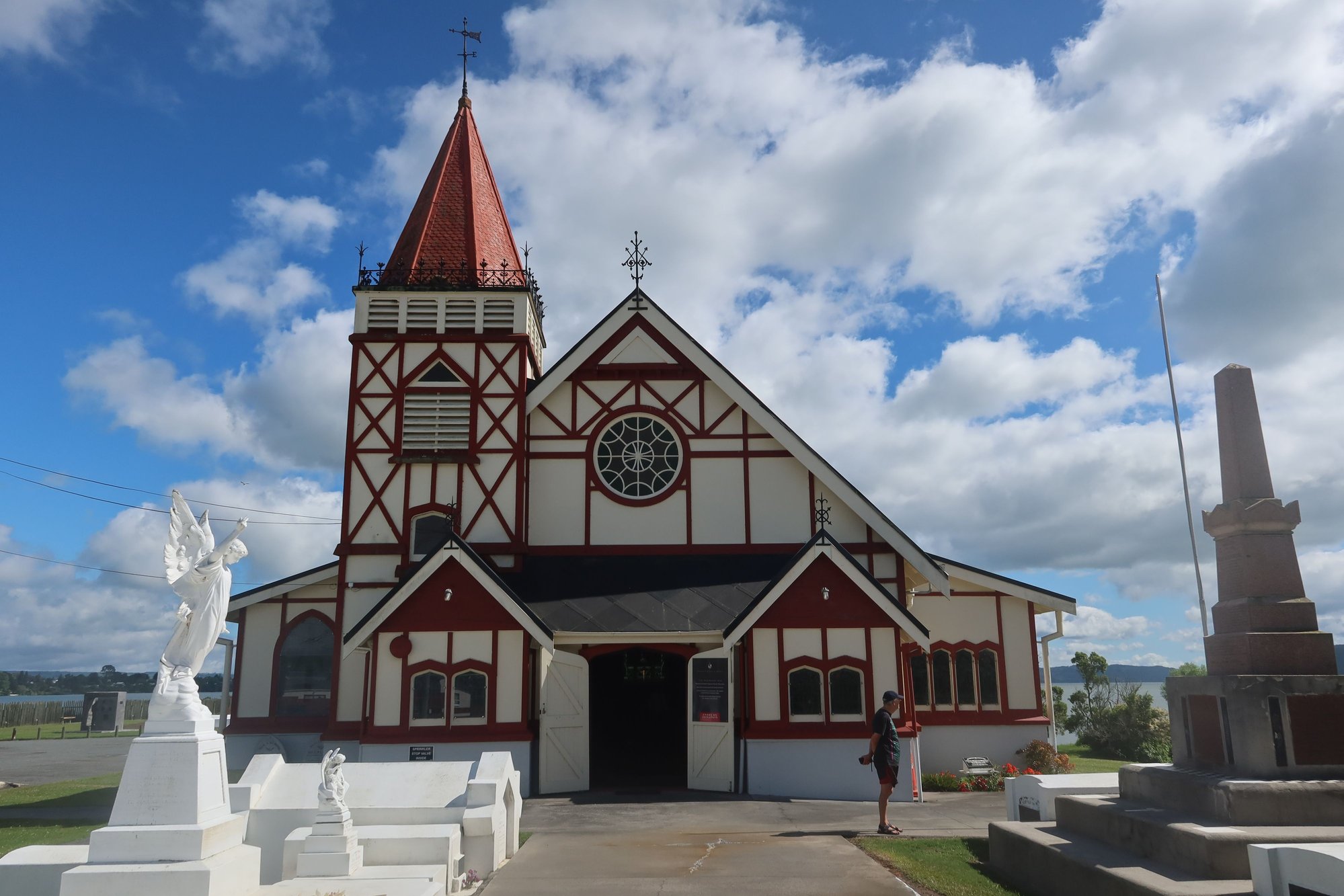
Near the end of the lakeside walkway is a Maori community, where we saw the outside of a Maori meeting house as well as St. Faith's Anglican Church with Maori carvings throughout. In each Maori community, village, or town is a meeting house that is used for residents to meet on matters as well as hold all of life's events and gatherings (weddings, graduation parties, funerals, birthdays, etc.). We also walked through Kuirau Park, with more boiling pools, streams, and other geothermal features. There are footbaths in the park as well.
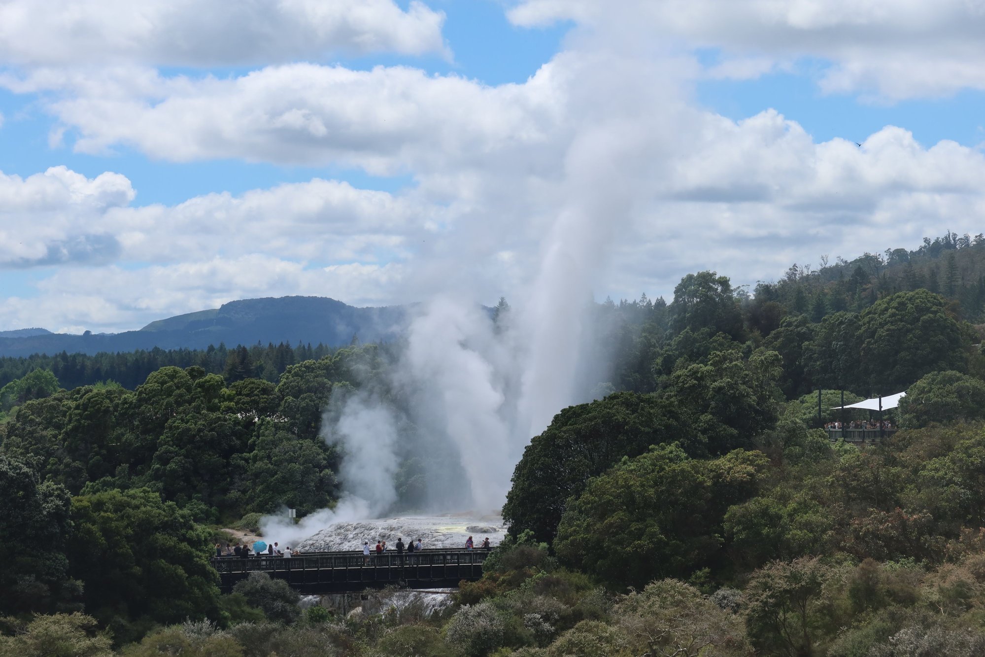
From here, we travelled by Uber to Te Puia. Visits to Te Puia are by guided tour although visitors are able to wander on their own afterwards. The tour focuses on the geology and natural history of the area. Highlights were three geysers including Pohotu, which shoots up about once an hour and can go up as high as 30 meters, and a kiwi enclosure where we saw an adult male kiwi and a baby kiwi. We also visited the Maori Arts Center, where we watched students work on wood carvings, jewelry, and weaving. We saw a 30-minute cultural performance of Maori song and dance. Te Puia is what I would call a Disneyland experience but we enjoyed getting to know more about the geology, flora, and fauna of the area that we may not have otherwise appreciated.
We also visited the Whakarewa village next door. Also a tourist attraction of sorts, the village remains inhabited. The 75-minute guided tour, led by a Maori resident, goes through the village,where we learned about the way of life of Maori in the area both past and present. The discussion about how Maori adapted to the environment was very interesting. We learned how locals used the thermal waters for cooking and for bathing. We learned how they are able to grow vegetables using imported soil on raised platforms. The guide also spoke about local customs and traditions. We also obtained a better understanding of the symbols used in Maori society. We didn't find visiting both Whakarewa and Te Puia redundant but complementary even though the three geysers could be viewed from both places (at Te Puia we got up close, whereas at Whakarewa we saw it from a distance). The last guided tour is at 3:00 PM.
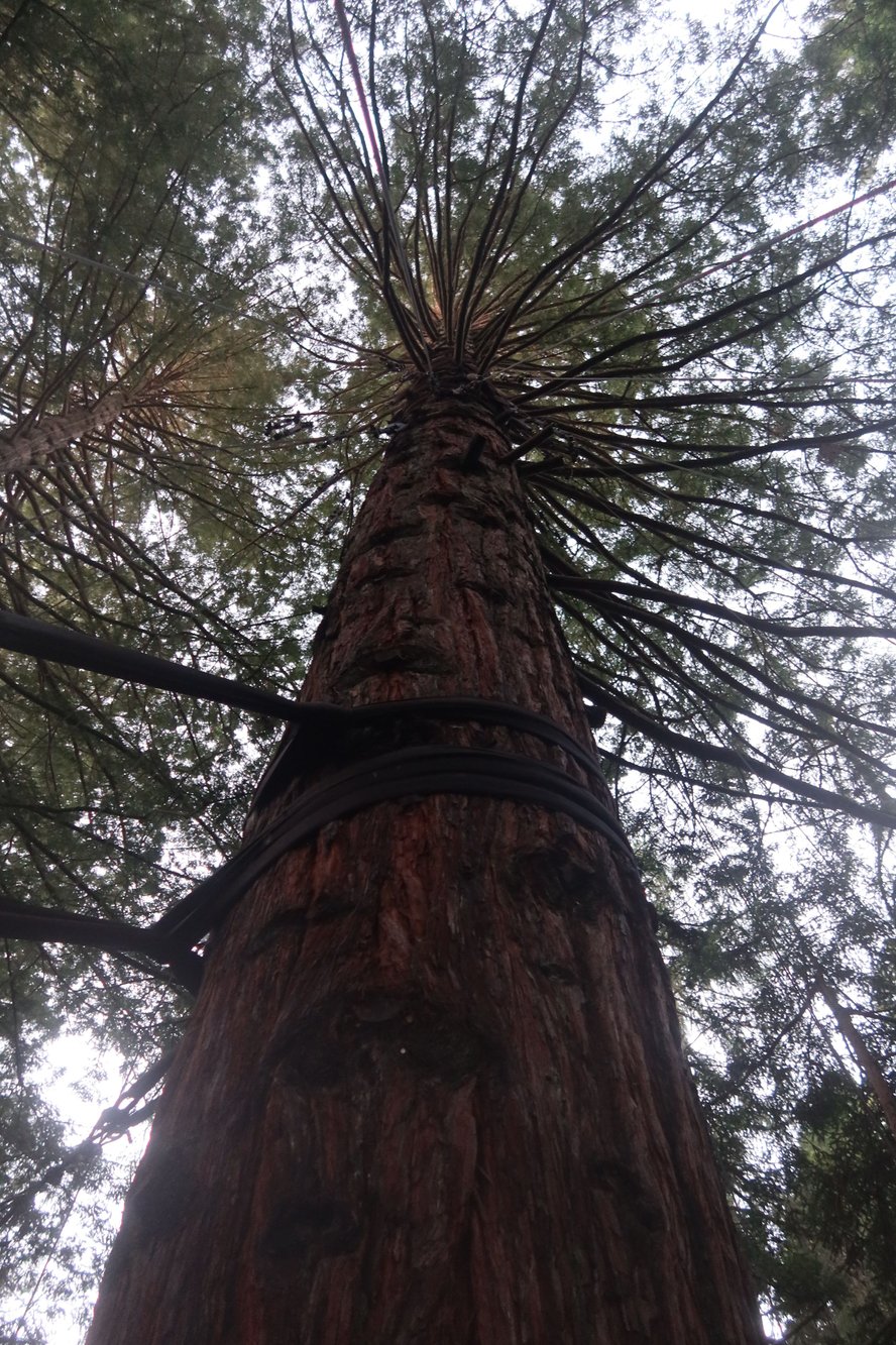
We returned to our hotel afterwards for a little bit of freshening up. We walked around the downtown area a bit before an early dinner at Leonardo's on Eat Streat, a strip of dining establishments. The atmosphere is good and the menu is Italian - pizzas, pastas, etc. After dinner, we visited the redwoods forest on the southern outskirts of the city. The tourist attention features a series of 23 connected swinging rope bridges going from tree to tree. The trees are as big and tall as we expect it to be. On the forest floor are different types of ferns that are native to New Zealand, as opposed to the redwoods, which were imported from California and planted in 1901. We felt like we were in a treehouse at times. And we get good exercise out of it to boot. We walked through the maze of bridges twice, once in the late evening again about 45 minutes later when it was fully dark and the man-made display of lanterns hanging from the trees all lit up. Another awesome, and very full, day.

Sulphur Point
Sulphur Point

Lake Rotorua

Meeting House by St. Faith
St. Faith's Anglican Church
Boiling Pool, Kuirau Park
Geysers at Te Puia
Mud Pool at Te Puia
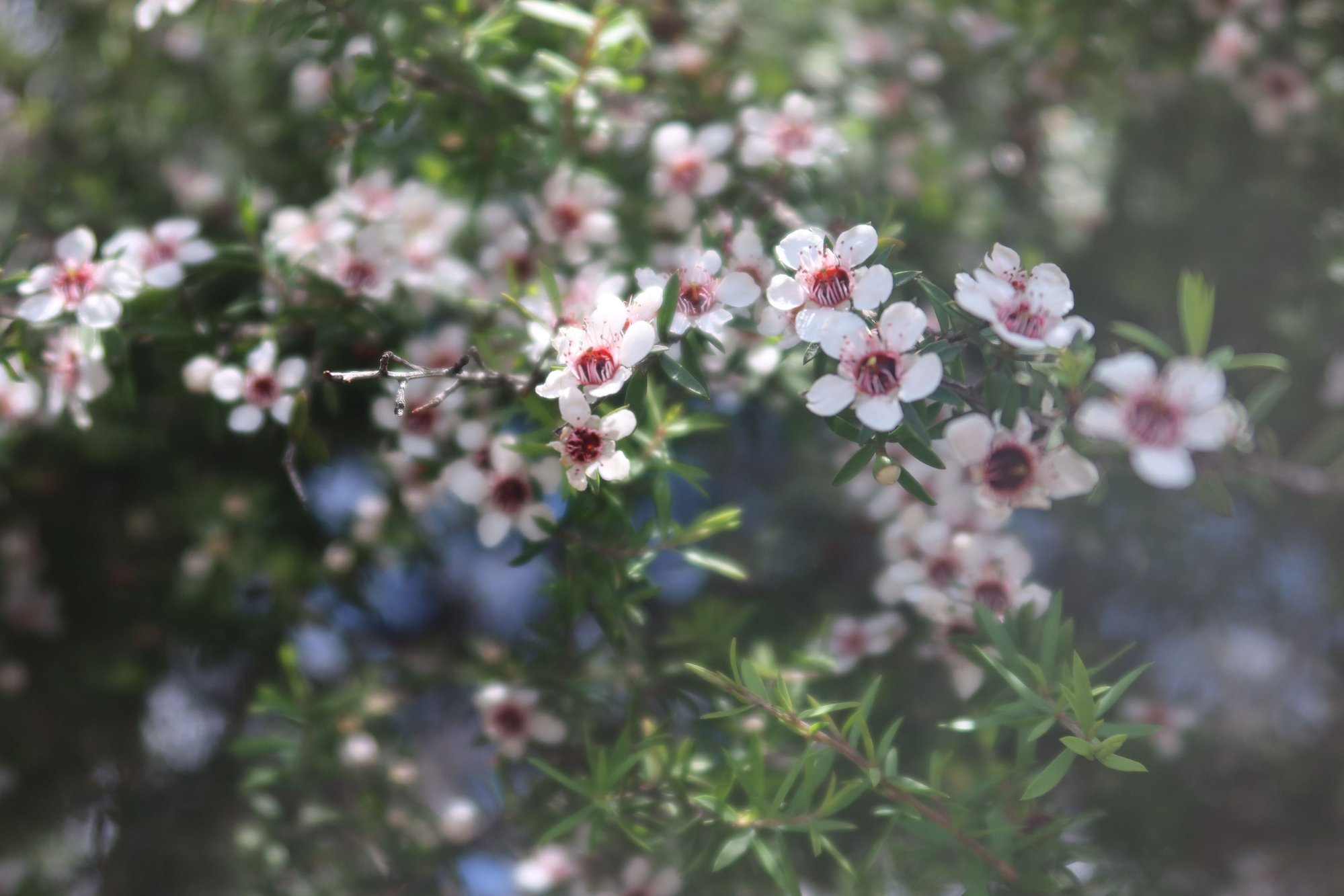
Manuka Flowers
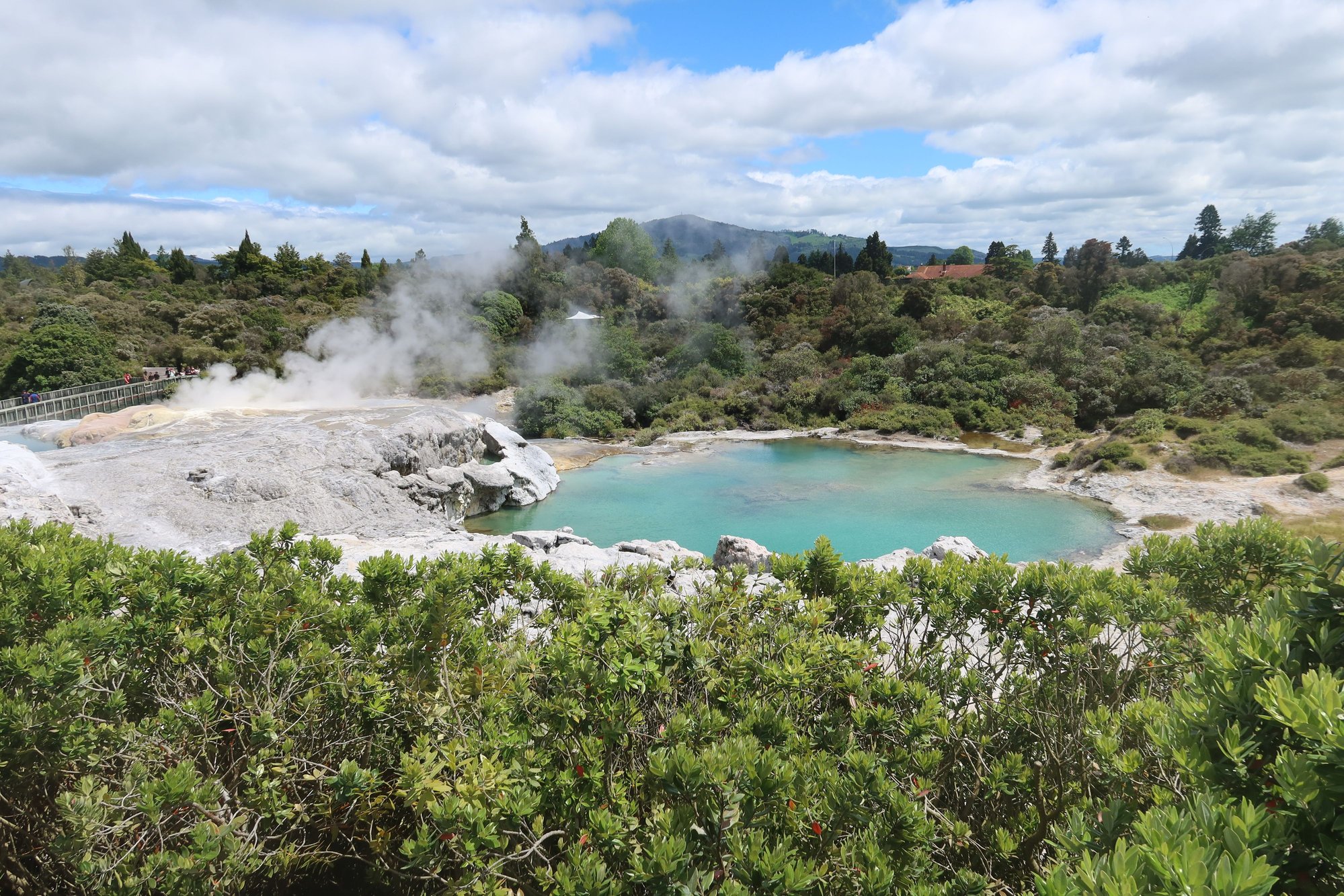
"Bluey" Pool at Te Puia
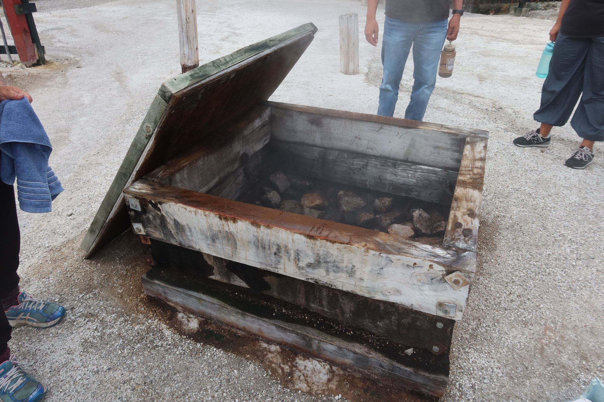
Cooking Oven at Whakarewa
Bathing Facility at Whakarewa
Redwood Tree

Ferns at the Redwood Forest

Lanterns at the Redwood Forest
Crossroads of History, Culture, and Geology
Rotorua is a small city located in the north central part of the North Island of New Zealand. Located on the western shores of a lake by the same name, Rotorua sits on a hotbed of geological activity. The area is home to numerous geysers, steam vents, mud pools, and other geothermal features, sitting atop an active volcanic field. The smell of sulfur and steam coming out of the ground seemingly out of nowhere permeates Rotorua.
We spent the first morning walking around the city center, focused on outdoor attractions (the one major indoor attraction, the Rotorua Museum, is closed undergoing earthquake-proofing). We began across the street from our hotel, the Prince's Gate Hotel, at Government Gardens. A public park today, scattered throughout the Gardens are numerous former meeting places, bath houses, and spas.
We walked through the Gardens, past Rachel Spring (a hot spring), and skirted the Polynesian Spa for the access point to Rotorua's lakeside trail. Near this section of the trail is Sulphur Point, so named for the number of geothermal features such as bubbling rivers and streams, steam vents, and the like. From this section and throughout the walk are wonderful views of Lake Rotorua, the mountains to the east, and numerous birds as well as black swans, a city icon.The walk was not only scenic but incredibly peaceful, an almost perfect way to start the day.
Near the end of the lakeside walkway is a Maori community, where we saw the outside of a Maori meeting house as well as St. Faith's Anglican Church with Maori carvings throughout. In each Maori community, village, or town is a meeting house that is used for residents to meet on matters as well as hold all of life's events and gatherings (weddings, graduation parties, funerals, birthdays, etc.). We also walked through Kuirau Park, with more boiling pools, streams, and other geothermal features. There are footbaths in the park as well.
From here, we travelled by Uber to Te Puia. Visits to Te Puia are by guided tour although visitors are able to wander on their own afterwards. The tour focuses on the geology and natural history of the area. Highlights were three geysers including Pohotu, which shoots up about once an hour and can go up as high as 30 meters, and a kiwi enclosure where we saw an adult male kiwi and a baby kiwi. We also visited the Maori Arts Center, where we watched students work on wood carvings, jewelry, and weaving. We saw a 30-minute cultural performance of Maori song and dance. Te Puia is what I would call a Disneyland experience but we enjoyed getting to know more about the geology, flora, and fauna of the area that we may not have otherwise appreciated.
We also visited the Whakarewa village next door. Also a tourist attraction of sorts, the village remains inhabited. The 75-minute guided tour, led by a Maori resident, goes through the village,where we learned about the way of life of Maori in the area both past and present. The discussion about how Maori adapted to the environment was very interesting. We learned how locals used the thermal waters for cooking and for bathing. We learned how they are able to grow vegetables using imported soil on raised platforms. The guide also spoke about local customs and traditions. We also obtained a better understanding of the symbols used in Maori society. We didn't find visiting both Whakarewa and Te Puia redundant but complementary even though the three geysers could be viewed from both places (at Te Puia we got up close, whereas at Whakarewa we saw it from a distance). The last guided tour is at 3:00 PM.
We returned to our hotel afterwards for a little bit of freshening up. We walked around the downtown area a bit before an early dinner at Leonardo's on Eat Streat, a strip of dining establishments. The atmosphere is good and the menu is Italian - pizzas, pastas, etc. After dinner, we visited the redwoods forest on the southern outskirts of the city. The tourist attention features a series of 23 connected swinging rope bridges going from tree to tree. The trees are as big and tall as we expect it to be. On the forest floor are different types of ferns that are native to New Zealand, as opposed to the redwoods, which were imported from California and planted in 1901. We felt like we were in a treehouse at times. And we get good exercise out of it to boot. We walked through the maze of bridges twice, once in the late evening again about 45 minutes later when it was fully dark and the man-made display of lanterns hanging from the trees all lit up. Another awesome, and very full, day.
Sulphur Point
Sulphur Point
Lake Rotorua
Meeting House by St. Faith
St. Faith's Anglican Church
Boiling Pool, Kuirau Park
Geysers at Te Puia
Mud Pool at Te Puia
Manuka Flowers
"Bluey" Pool at Te Puia
Cooking Oven at Whakarewa
Bathing Facility at Whakarewa
Redwood Tree
Ferns at the Redwood Forest
Lanterns at the Redwood Forest
Nov 21st, 2025 | 01:10 AM
#12
Original Poster
Joined: Sep 2012
Posts: 3,567
Likes: 0
Full of Hot Air AND In Hot Water
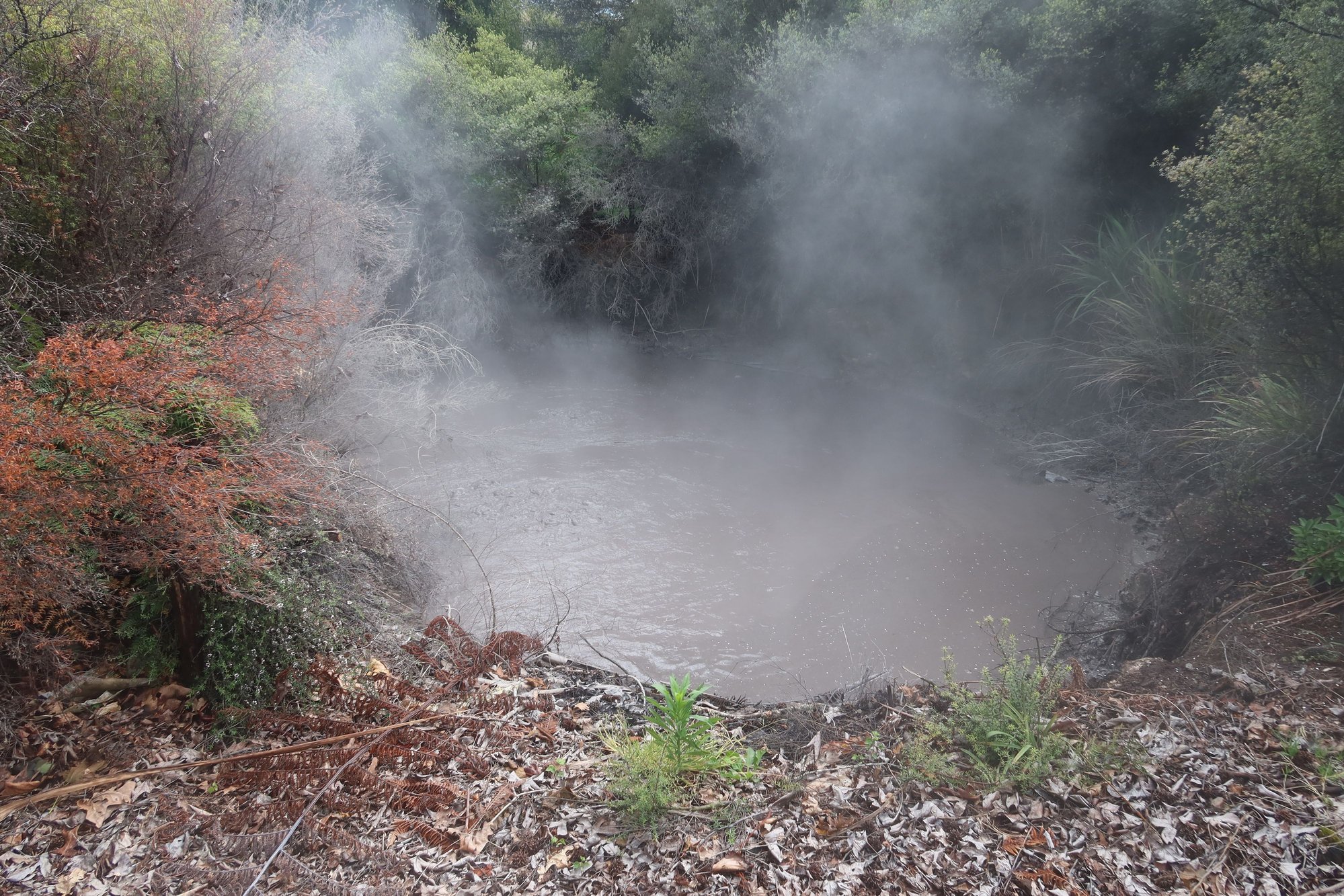
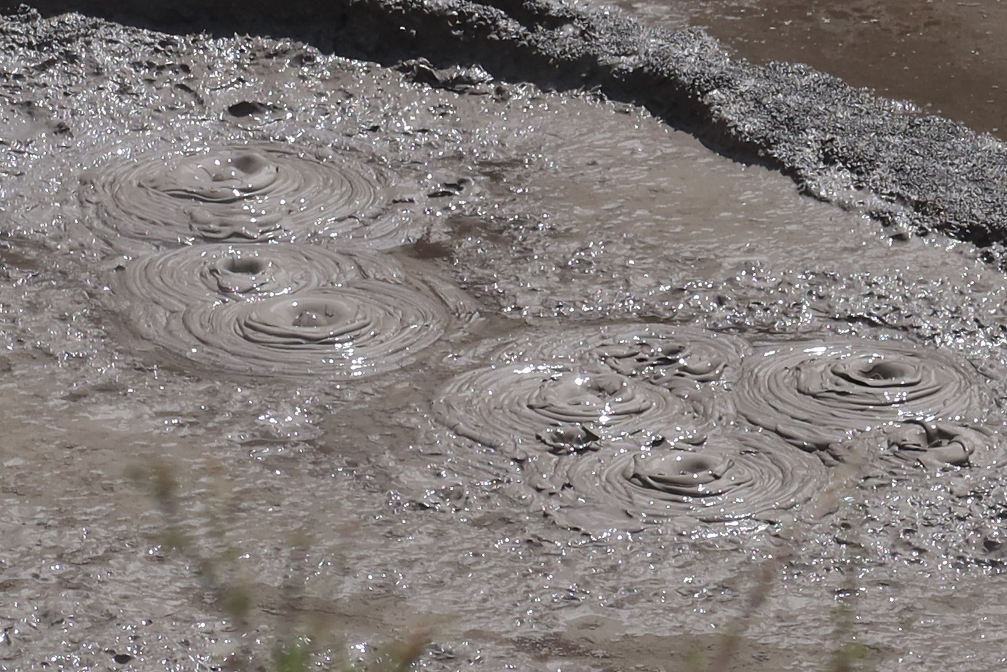
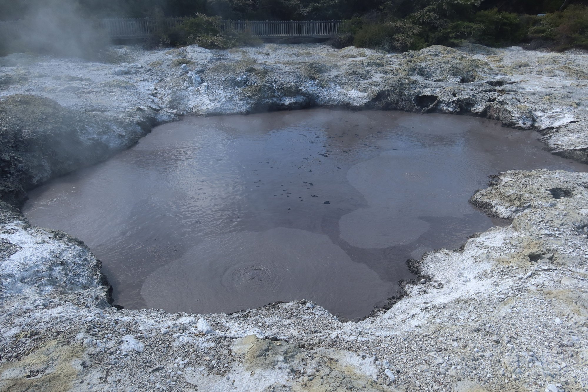
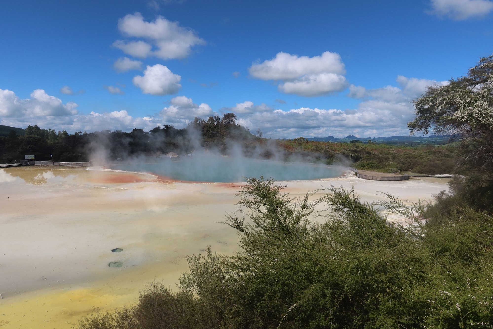
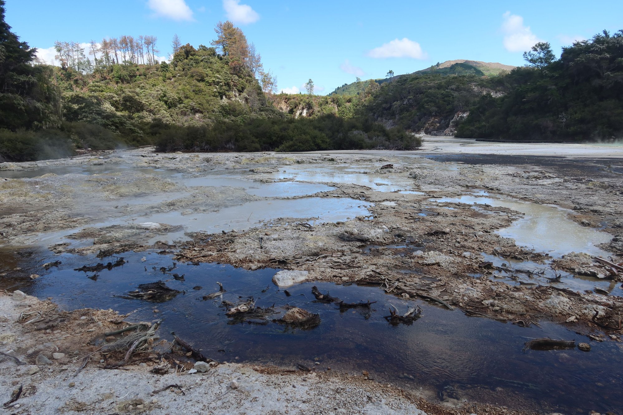
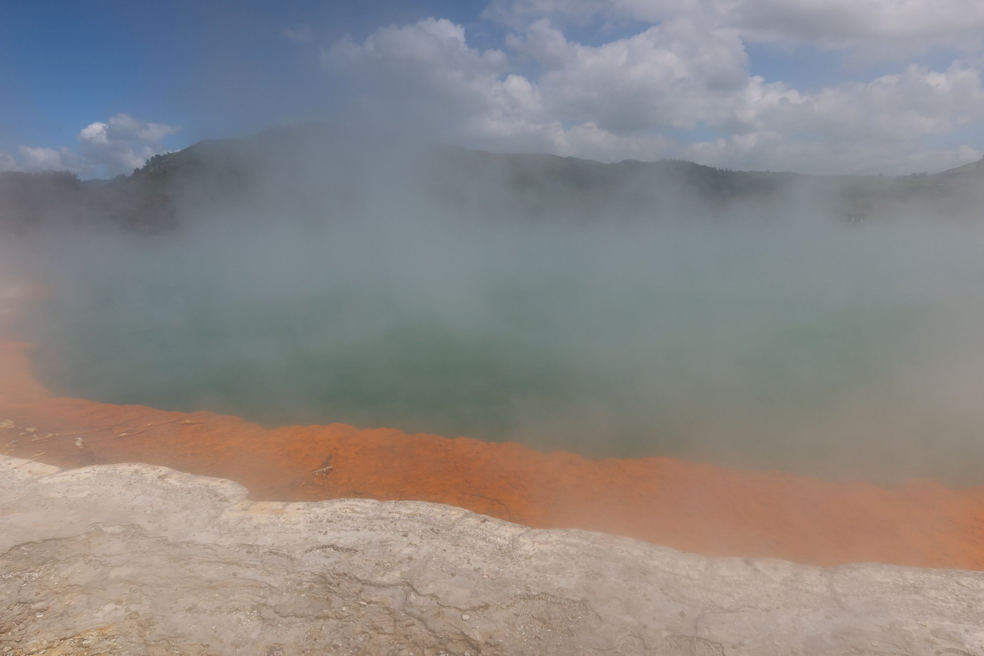
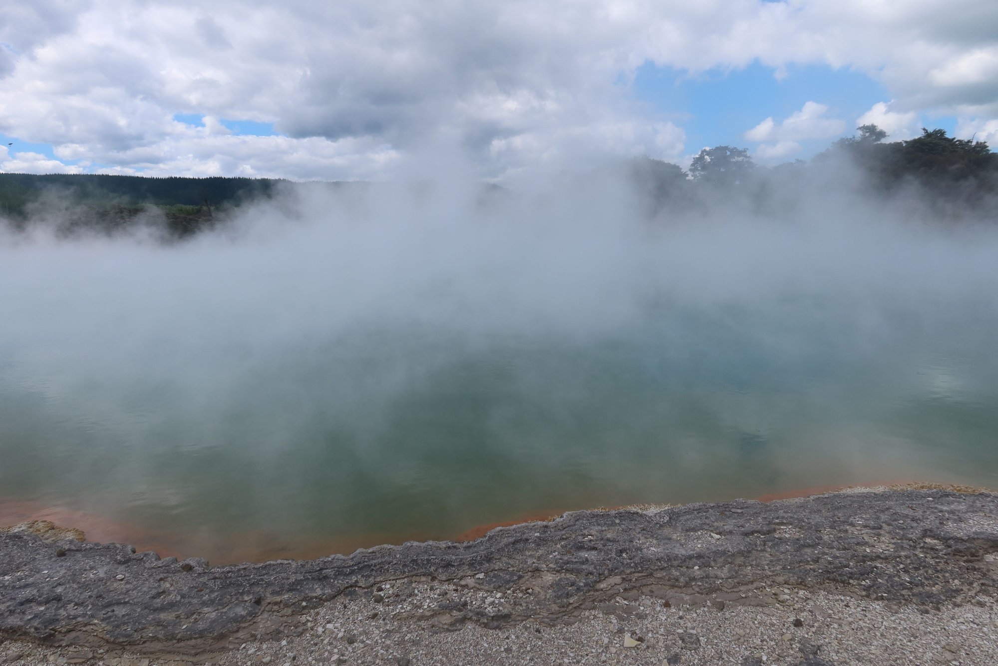
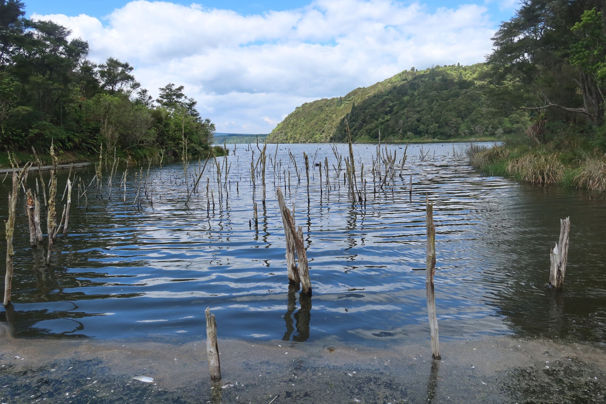
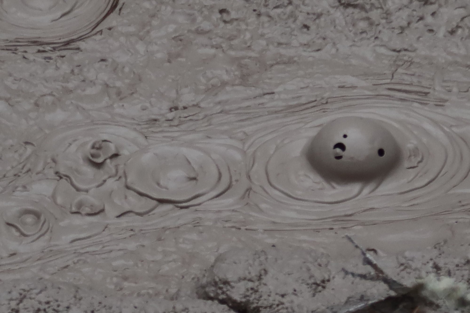
The geothermal theme permeates our second full day in Rotorua. We spent the majority of the day visiting two attractions south of Rotorua: Wai-O-Tapu Thermal Wonderland and Waimangu Volcanic Valley. Both Wai-O-Tapu and Waimangu are nature trails coursing through geothermal fields. Each featured boiling pools, mud pools, steam vents, and craters. A major highlight at Wai-O-Tapu is the Champaign Pool, a massive pool of booking water rimmed by brilliant orange and blue from the minerals left behind by the hot water. The highlights at Waimangu are a few crater lakes left behind by the eruption of Mount Tarawera in the late 19th century. Both attractions feature a stream of terraces created by the flowing hot water, although the ones at Waimangu were more impressive with its bright hues. Wai-O-Tapu has more barren geology whereas Waimangu sits in a fertile valley of fern trees and features a wetlands area with good birdlife. Mount Tarawera is visible from Waimangu. We were happy with our decision to visit both and would make the same choice again without hesitation. The geothermal landscape is unique and found in only a few parts of the world. It's hard for me to give justice to what we experienced through words but here is a collection of photos from today.
Food and Entertainment
The only meal for us to speak about are a couple of dinners and an evening cultural performance with food included. We ate breakfast at our hotel, the Prince's Gate, which consisted of a simple but adequate spread of hot items you would expect with an English breakfast. Lunch were at the cafes where we were touring, Te Puia yesterday and Waimangu today; both were typical of what you would find in such places.
Dinner on our first night in Rotorua was at The Fainting Goat, a pub a couple of blocks from our hotel. The gastropub offers what you would find in such an establishment but everything we ordered was well-prepared.
Dinner our second night was at Leonardo's, an Italian place along Eat Streat, with a collection of a dozen dining establishments along one city block. The pizzas and pastas were good and what you would find in a neighborhood Italian joint.
We spent our final night at Te Pa Tu, one of the Maori cultural performance shows in a nearby village. We were picked up by a motorcoach that went around the city's hotels collecting passengers, and were driven to the village about 15 minutes outside the city, actually on the main road leading to Wai-O-Tapu and Waimangu. We were greeted by a welcome ceremony, saw demonstrations of Maori games and fighting techniques, viewed a song and dance performance, and enjoyed a four-course meal. While touristy, it made for a good evening and the end of our time in Rotorua.
It's hard to believe that we already one-third of our way through our trip. Time has flown by.
Nov 21st, 2025 | 09:02 PM
#14
Original Poster
Joined: Sep 2012
Posts: 3,567
Likes: 0
KarenWoo, thank you. We all loved the Rotorua area for geothermal fields and Maori culture. We were very happy we visited.
On the Road Again
We left Rotorua this morning and continued our journey southward on the North Island, towards New Zealand's capital city, Wellington. Before we head to Wellington, we are spending a couple of days in Tongariro National Park where we will attempt the Alpine Crossing.
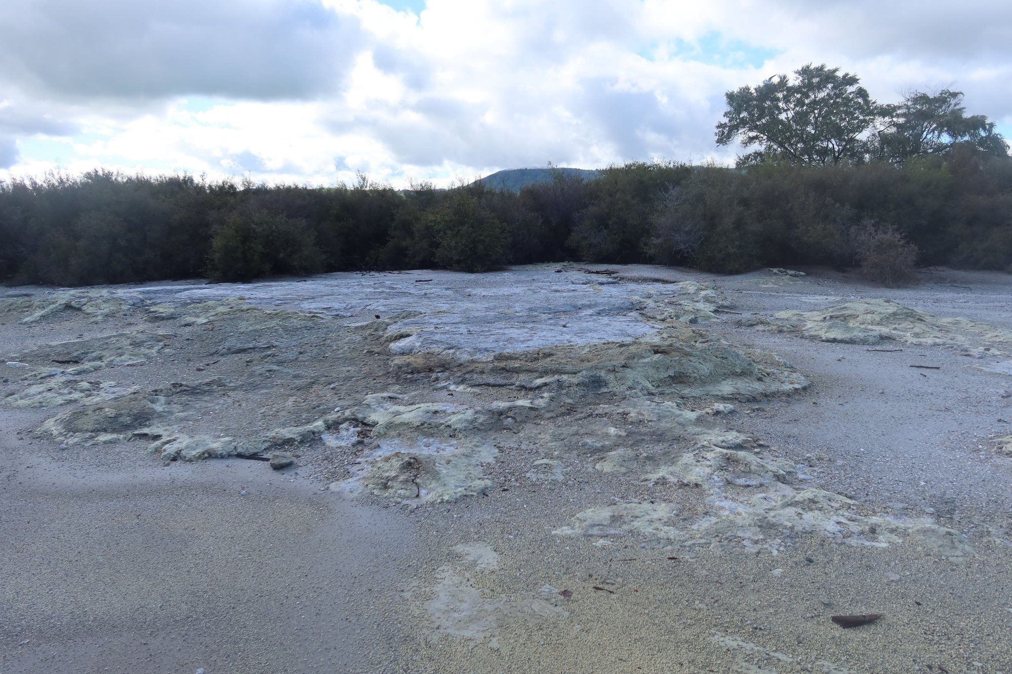
From Rotorua, we travel on State Highway 5, the same route to took yesterday to Wai-O-Tapu and Waimangu. Our first stop of the way was Orakei Korako, another geothermal park. The highlight of the park is a massive silica terrace that cascades down the side of a hill into a lake. The terrace is filled with various geysers and boiling pools of waters, in an explosion of color. It looked like someone took different colors of paint and threw it down on the terrace. We were able to get very close to the terrace for wonderful views. There are also mud pools, steam vents, and waterfalls.
We continued on south, to Huka Falls, just outside of the city of Taupo. Along the way we caught our first glimpses of the three volcanoes that lay within Tongariro National Park. I noticed a mountain to the south of us with snow on top and thought that this must be Mount Ruapehu; it was confirmed by our driver. Directly next to it on the right was Mount Ngauruhoe and to the right of it Mount Tongariro. Our anticipation built - we've been eager to hike the Tongariro Alpine Crossing and it's almost surreal that this is what we aim to do tomorrow.
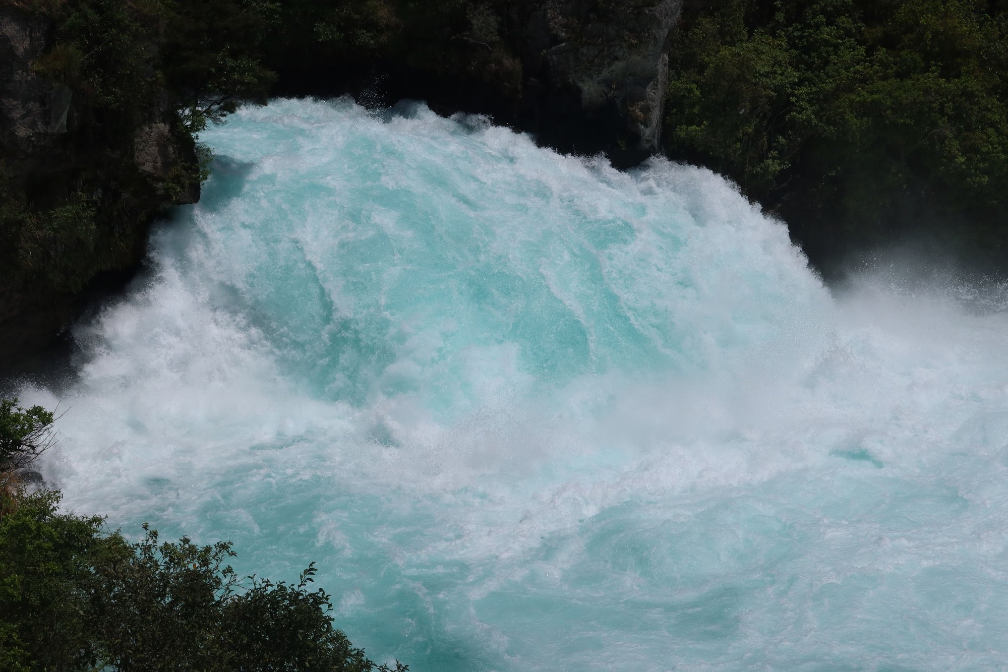
Back to today's business, we visited Huka Falls. Flowing down the Waikato River from Lake Taupo to the south, the waters are white and baby blue and cold. We could feel the cold breeze emanating from the fast-flowing Waikato River even from the walkway alongside it fairly high above. It was a beautiful day so a good number of people were out and about. We never get tired of waterfalls.
From there it was 15 minutes to Taupo city center, where we enjoyed a short walk along the lakefront and had a quick lunch before our cruise on Lake Taupo. It was a warm, sunny afternoon - perfect weather for sailing. The 90-minute cruise took us around the northern end of the lake. We saw the three volcanoes of Tongariro National Park, beautiful homes around Acacia Bay, and the crown jewel of the lake - a Maori rock carving at Mine Bay. We sailed very close to this awe-inspring monument. The captain made sure everyone had good views. Following the cruise, we drove along the eastern side of the lake, to Turangi and the Tongariro Lodge, our home for the next three nights.
Turangi is well-known in New Zealand for its trout and the Tongariro Lodge is considered a great fishing lodge. The 2-bedroom villa we rented is huge with a large open-concept living and dining area, kitchen, 2 bedrooms, and 2 bathrooms. It was a lodge cabin atmosphere, which is appropriate for the area.
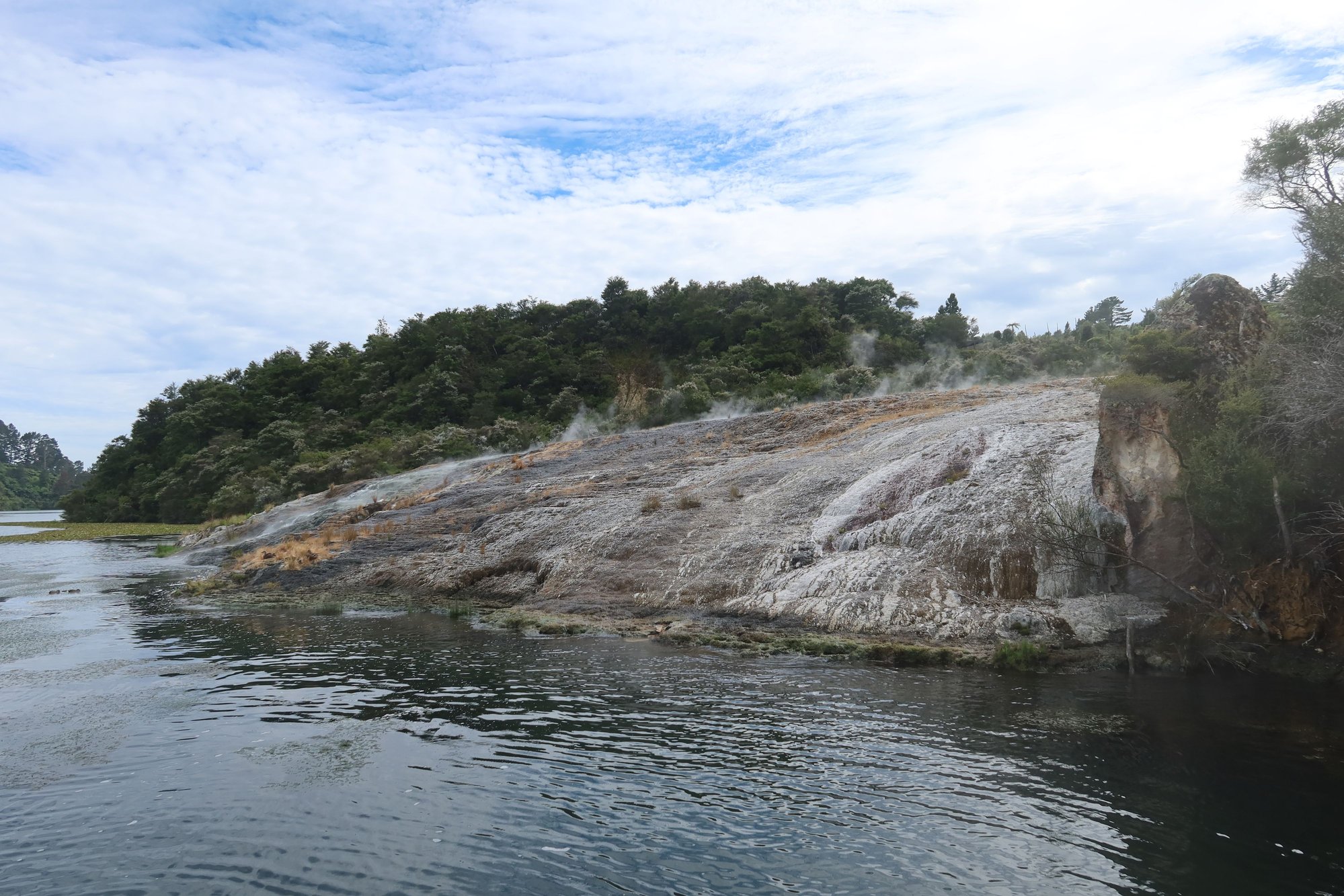
Silica Terrace, Orakei Korako

Boiling Pool, Orakei Korako
Mud Pool, Orakei Korako

Silica Terrace, Orakei Korako

Waikato River
Huka Falls
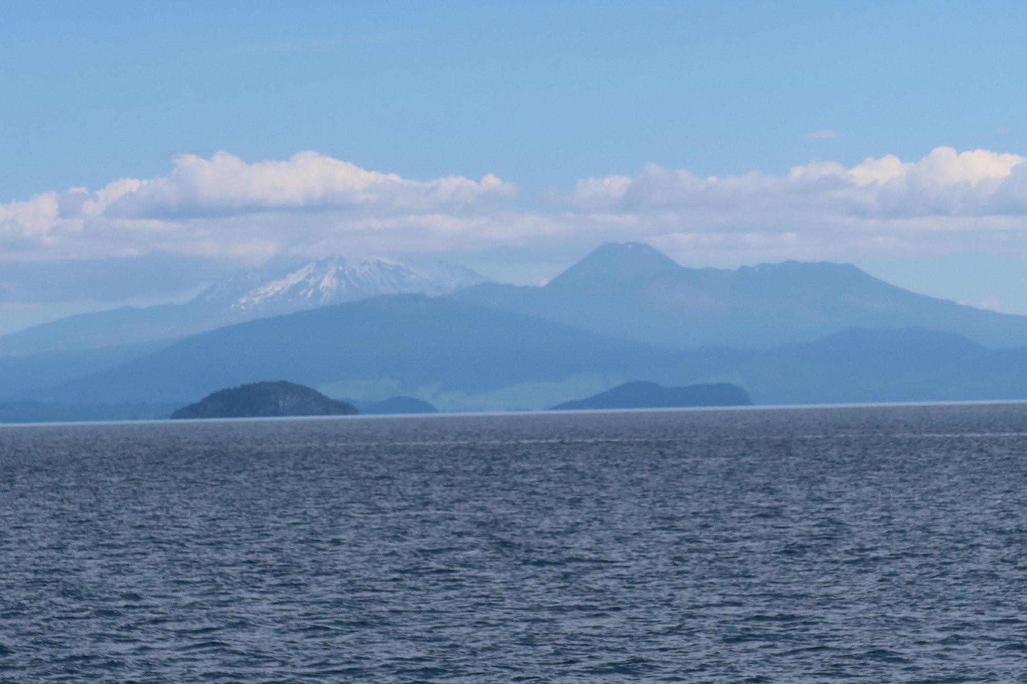
Tongariro Volcanoes and Lake Taupo

Maori Rock Carving at Mine Bay, Lake Taupo
On the Road Again
We left Rotorua this morning and continued our journey southward on the North Island, towards New Zealand's capital city, Wellington. Before we head to Wellington, we are spending a couple of days in Tongariro National Park where we will attempt the Alpine Crossing.
From Rotorua, we travel on State Highway 5, the same route to took yesterday to Wai-O-Tapu and Waimangu. Our first stop of the way was Orakei Korako, another geothermal park. The highlight of the park is a massive silica terrace that cascades down the side of a hill into a lake. The terrace is filled with various geysers and boiling pools of waters, in an explosion of color. It looked like someone took different colors of paint and threw it down on the terrace. We were able to get very close to the terrace for wonderful views. There are also mud pools, steam vents, and waterfalls.
We continued on south, to Huka Falls, just outside of the city of Taupo. Along the way we caught our first glimpses of the three volcanoes that lay within Tongariro National Park. I noticed a mountain to the south of us with snow on top and thought that this must be Mount Ruapehu; it was confirmed by our driver. Directly next to it on the right was Mount Ngauruhoe and to the right of it Mount Tongariro. Our anticipation built - we've been eager to hike the Tongariro Alpine Crossing and it's almost surreal that this is what we aim to do tomorrow.
Back to today's business, we visited Huka Falls. Flowing down the Waikato River from Lake Taupo to the south, the waters are white and baby blue and cold. We could feel the cold breeze emanating from the fast-flowing Waikato River even from the walkway alongside it fairly high above. It was a beautiful day so a good number of people were out and about. We never get tired of waterfalls.
From there it was 15 minutes to Taupo city center, where we enjoyed a short walk along the lakefront and had a quick lunch before our cruise on Lake Taupo. It was a warm, sunny afternoon - perfect weather for sailing. The 90-minute cruise took us around the northern end of the lake. We saw the three volcanoes of Tongariro National Park, beautiful homes around Acacia Bay, and the crown jewel of the lake - a Maori rock carving at Mine Bay. We sailed very close to this awe-inspring monument. The captain made sure everyone had good views. Following the cruise, we drove along the eastern side of the lake, to Turangi and the Tongariro Lodge, our home for the next three nights.
Turangi is well-known in New Zealand for its trout and the Tongariro Lodge is considered a great fishing lodge. The 2-bedroom villa we rented is huge with a large open-concept living and dining area, kitchen, 2 bedrooms, and 2 bathrooms. It was a lodge cabin atmosphere, which is appropriate for the area.
Silica Terrace, Orakei Korako
Boiling Pool, Orakei Korako
Mud Pool, Orakei Korako
Silica Terrace, Orakei Korako
Waikato River
Huka Falls
Tongariro Volcanoes and Lake Taupo
Maori Rock Carving at Mine Bay, Lake Taupo
Nov 22nd, 2025 | 05:48 AM
#15

Joined: Sep 2019
Posts: 500
Likes: 0
Along for the ride, as we plan a March -April visit.
Your Coast to Coast walk in Auckland goes on the list! And your lively descriptions of the Rotorua attractions really helps to focus our limited time there.
Looking forward to more.
Your Coast to Coast walk in Auckland goes on the list! And your lively descriptions of the Rotorua attractions really helps to focus our limited time there.
Looking forward to more.
Nov 22nd, 2025 | 08:07 PM
#16
Joined: Jan 2015
Posts: 4,298
Likes: 19
Happy to read your NI experiences, and especially looking forward to your northern part of SI which I hope to visit sometime.
I loved the Hobbiton photos, so charming and idyllic, with cute gardens. We lived underground in the outback and it would have been much more pleasant to live like the hobbits!
I loved the Hobbiton photos, so charming and idyllic, with cute gardens. We lived underground in the outback and it would have been much more pleasant to live like the hobbits!
Nov 23rd, 2025 | 01:27 AM
#17
Original Poster
Joined: Sep 2012
Posts: 3,567
Likes: 0
FTOttawa, feel free to ask questions as you plan. I would be more than happy to answer it. The challenge with New Zealand is that there is so much to see and do and limited time. You really have to make choices.
Adelaidean, thank you. I agree that living like hobbits could be nice; the village felt so peaceful being in nature with sheep running around.
Tongariro Alpine Crossing
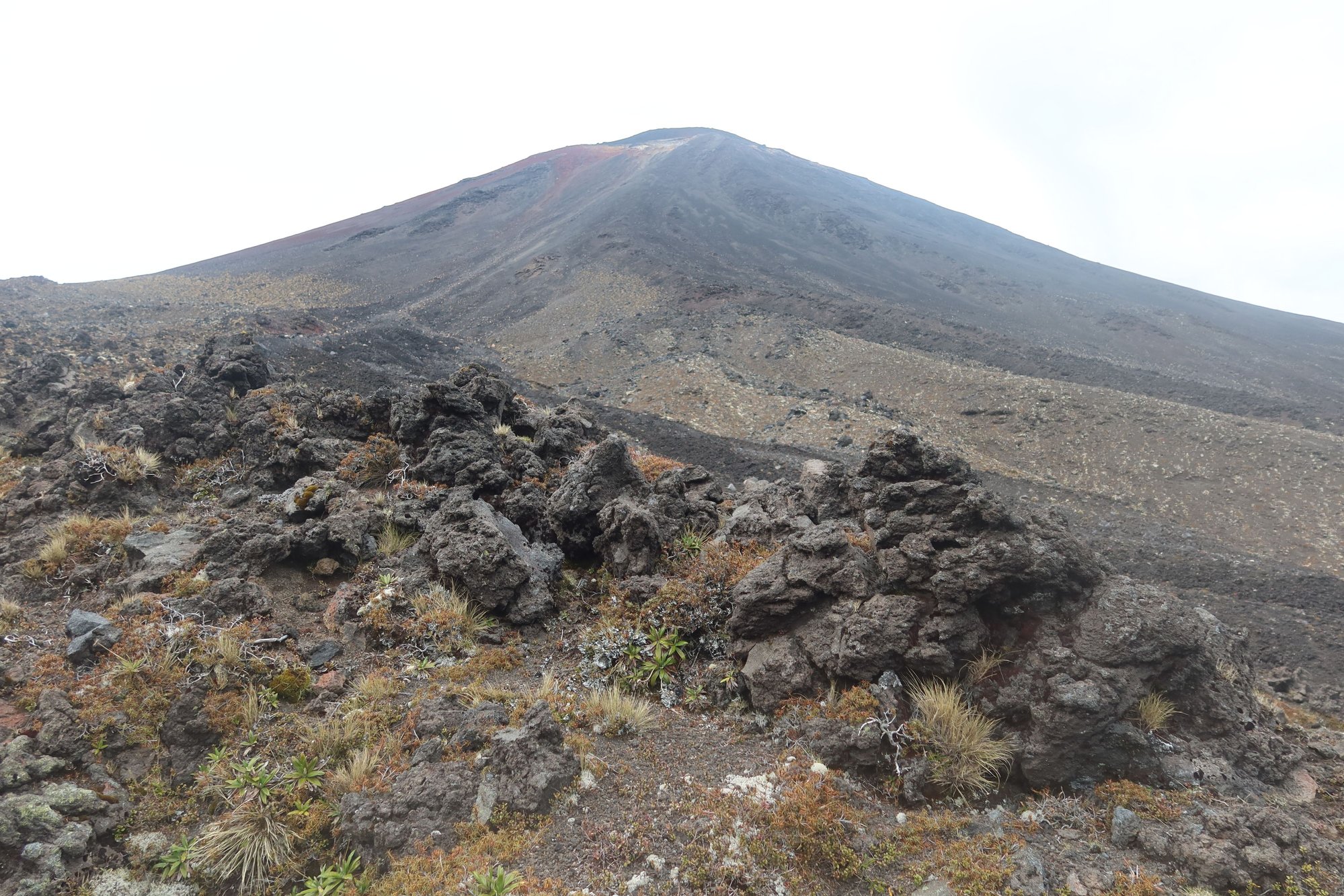
In the central part of the North Island of New Zealand south of Lake Taupo lies Tongariro National Park, the country's first national park. Founded in the late 19th century from lands donated by two local Maori tribes in the name of conservation, Tongariro is home to multiple volcanoes including Mount Tongariro, the namesake of the park; Mount Ruapehu; and Mount Ngauruhoe (aka Mount Doom of Lord of the Rings fame). Tongariro National Park is an UNESCO World Heritage Site, and the Tongariro Alpine Crossing is the most popular way to experience this park.
Just about two weeks again, a wildfire swept through the area including a portion of Tongariro National Park. While scientists are still assessing the damage, the park was reopened to the public just this past Monday. We were following the developments in the past couple of weeks, both because of what was lost but also because this was one of the major reasons for our return trip to New Zealand.
Did the Tongariro Alpine Crossing live up to its expectations? Yes and no.
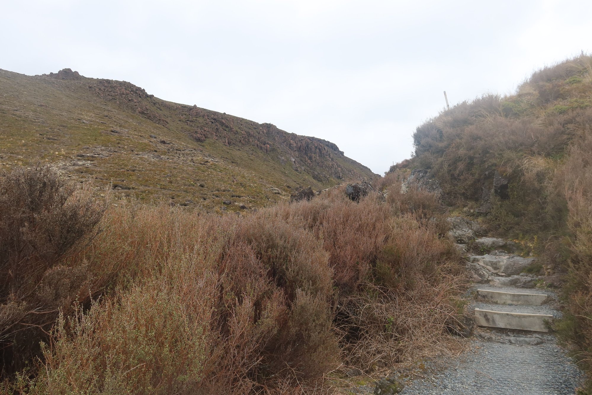
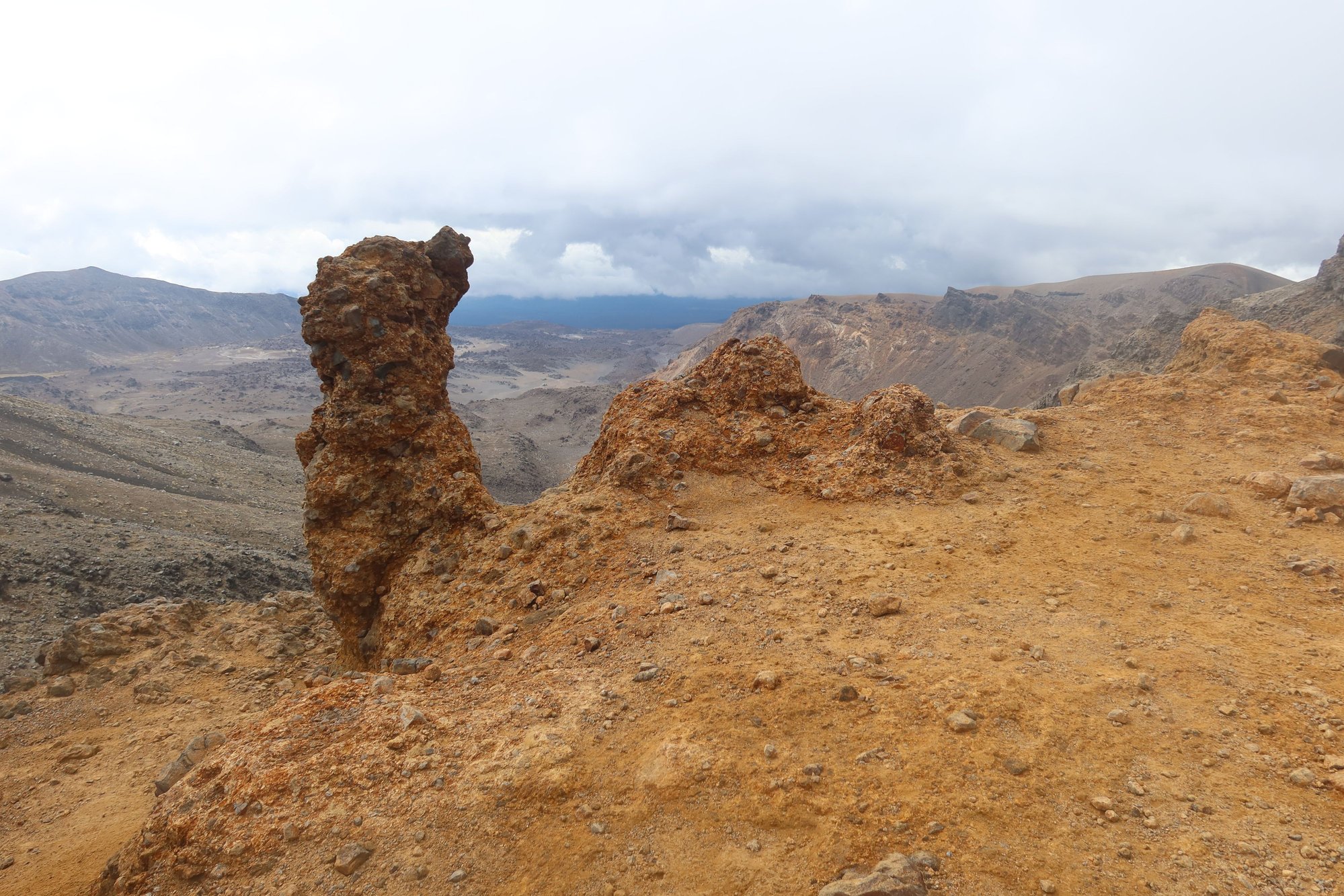
We travelled by taxi to Mangatepopo car park, the start of the 20.2-kilometer hike across varied terrain. The first section of the track is fairly straight forward. Most of the walk through the Mangatepopo Valley is on boardwalk, with mountains on both sides and volcanic landscape along much of the way. However, part of this section was burned by the wildlife last week, and along the first kilometer, we walked past a lot of the destruction. This was a very sad sight to see. The tussock began to appear again as we neared Mangatepopo Stream. What should have taken us an hour to an hour and a half took us two. I guess we took too many breaks along the way.
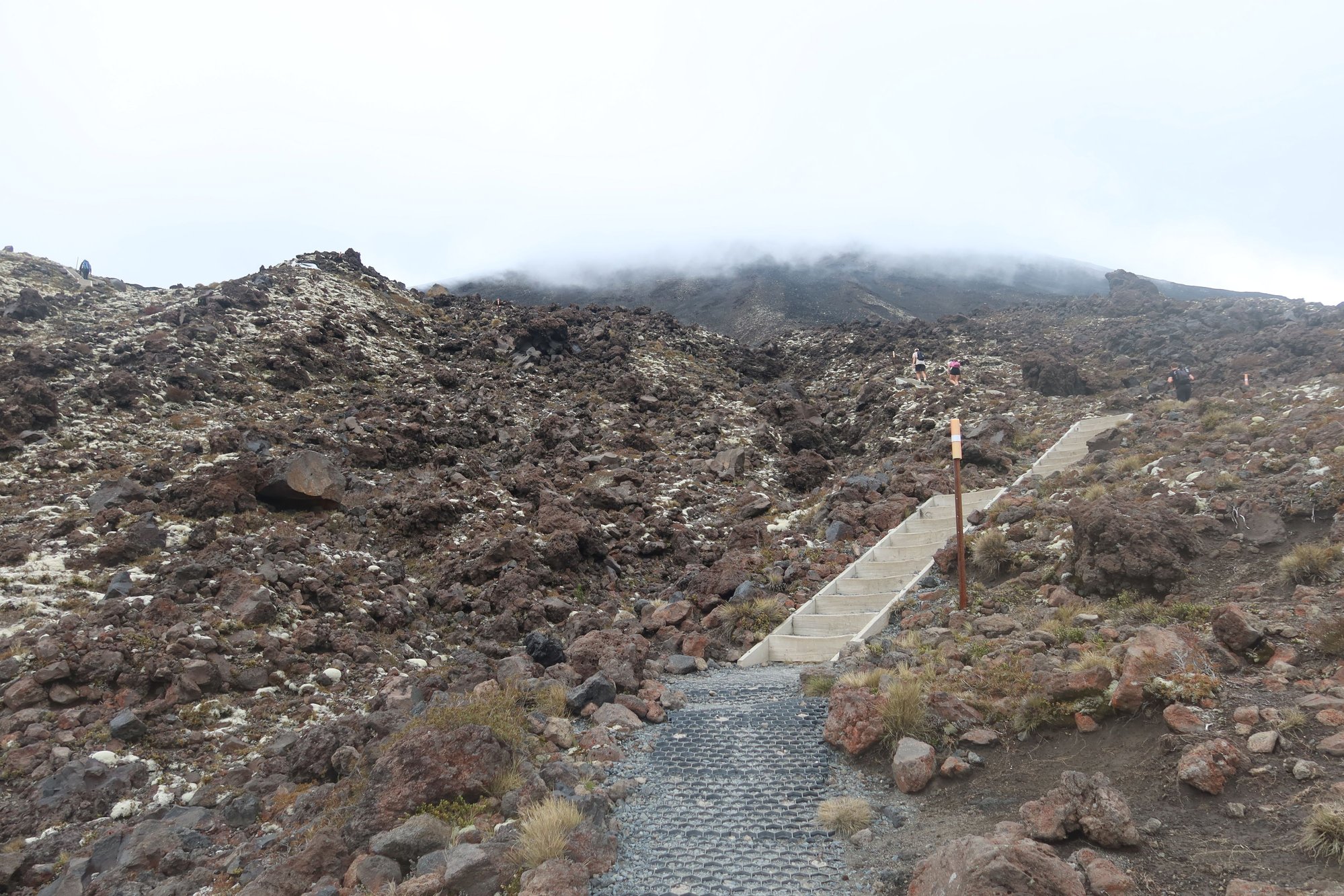
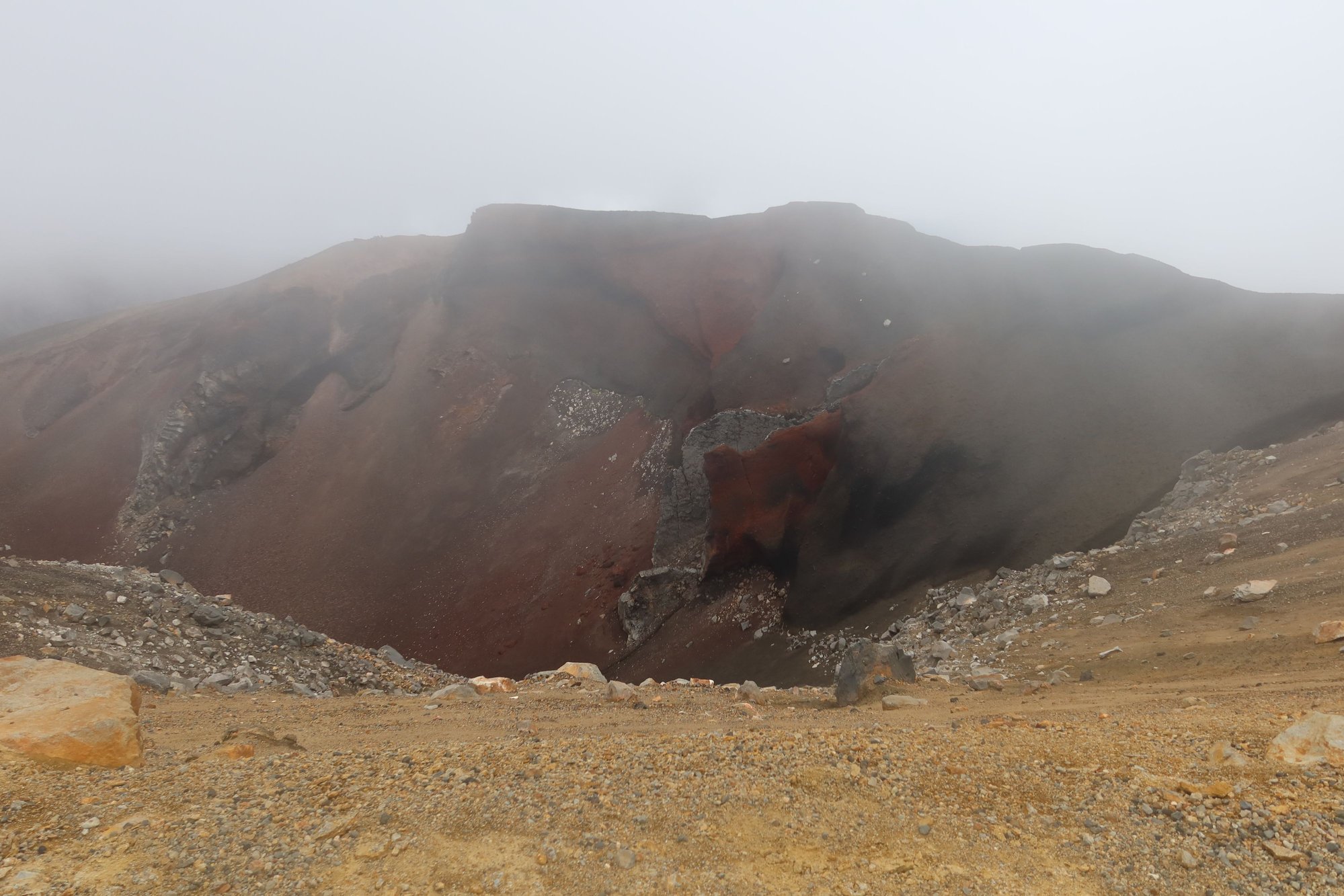
From here the trail winds up, along a series of staircases called the Devil's Staircase. This section of the hike was not difficult but long and there was about a 300-meter elevation gain. As soon as we ascended the Devil's Staircase, Mount Ngauruhoe came into view. The volcano only showed itself for a brief period as the fog soon rolled in and much of the landscape became enveloped in fog. We took an hour and a half, longer than what this section called for. The fog rolled out briefly again, allowing us glimpses of Mount Tongariro and the South Crater, but this was rather fleeting.
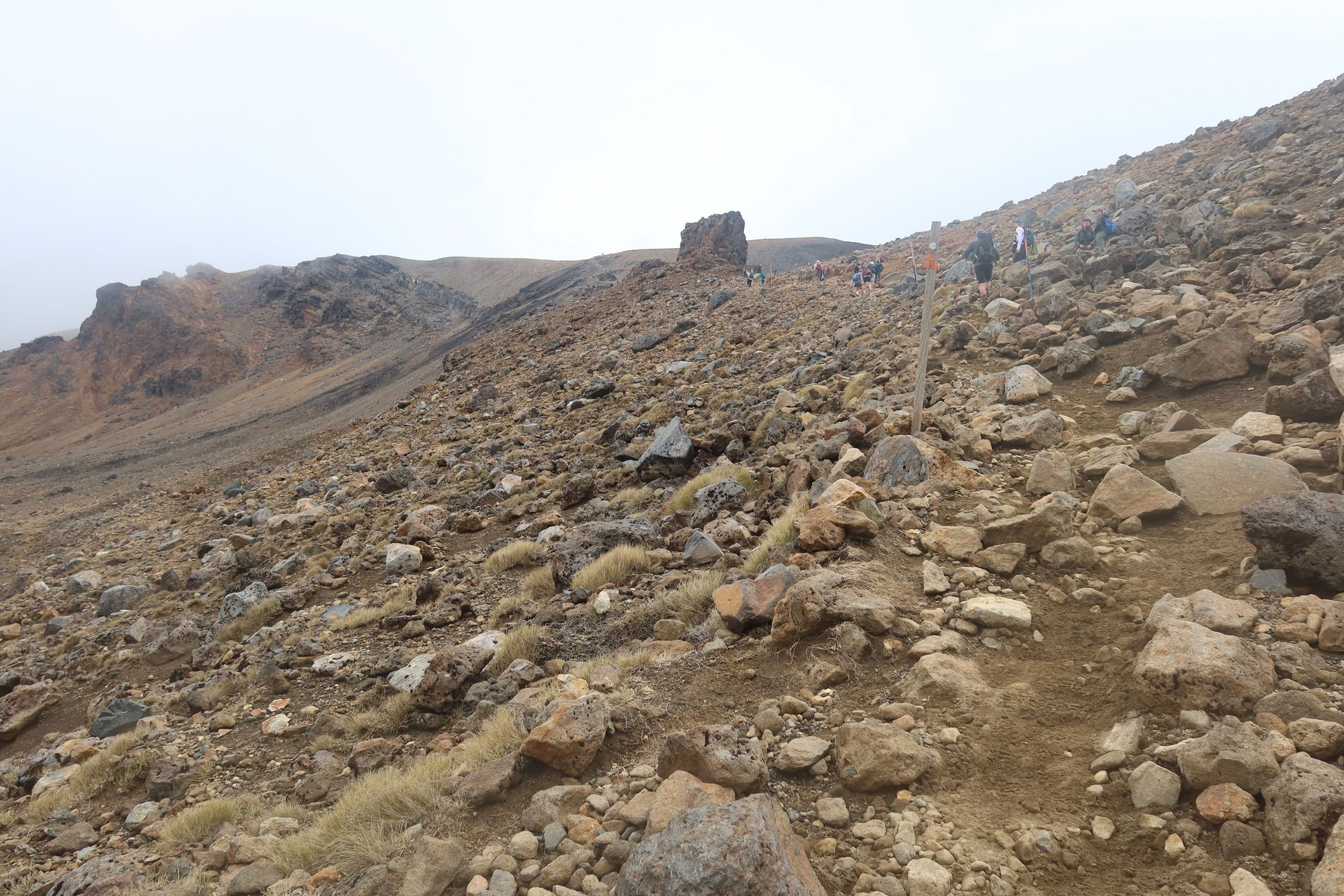
A few hours into the hike, we ascended Mount Tongariro, towards the Red Crater - a highlight of the Crossing. Unfortunately, the fog rolled back in and was intensively thick, making nothing visible. At this point, we were thinking - is the hike even worth it? We took another hour and a half to navigate loose rocks on our ascent of Mount Tongariro. We were yelled at by a mountain guide for being slow and holding up others at a couple of points. And to add salt to our wounds, there were no views to be had whatsoever.
The Red Crater came into view for a couple of minutes, and then nothing was visible again. Worse, it began to rain, a few hours earlier than forecasted. This meant we were unable to enjoy some of the classic views from the park that hikers are able to enjoy on a nice day. We were wet and unhappy. To add insult to injury, navigating down the other side of Tongariro was a bear - the entire way was covered with loose volcanic rock and sand. Yes, we felt on our bums not once but two and three times. What should have taken us 30 minutes took us three times as long.
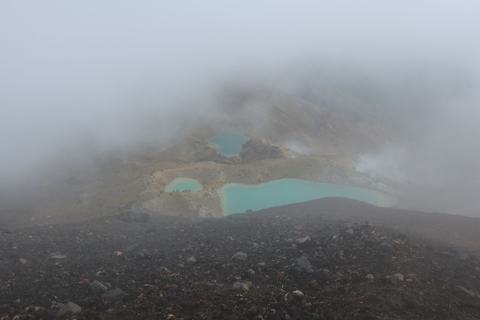
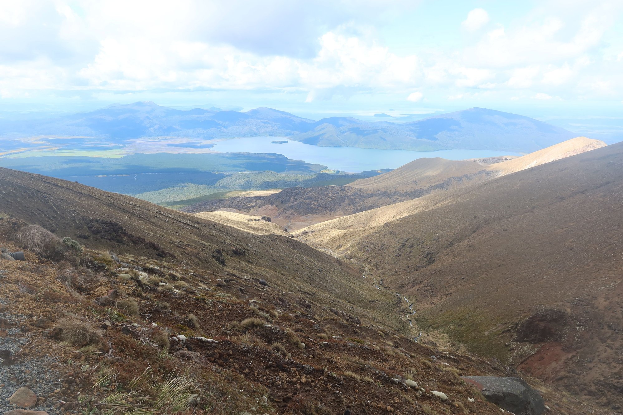
At the bottom of the Mount Tongariro were three emerald lakes, the color coming from the minerals from the volcano. After passing the emerald lakes and reaching Blue Lake, where we began our descent towards Ketetahi car park, the end of the hike. To our dismay, we still had 11 kilometers to go. The upshot was that the fog rolled out in part and the sun came out. We were able to enjoy some nice vistas - to the north to Lake Taupo and beyond. While the rest of the way was not technical, the long descent, complete with switchbacks, took a toll on us. The 4-plus hour trip seemed endless. At this point, we were tired and grumpy, and what we saw became repetitive - trees and fern, which we could appreciate from anywhere in New Zealand.
Most hikers take six to eight hours to complete the Tongariro Alpine Crossing. We took 12.5. We were the last ones to leave the trail this evening. While we enjoyed some nice scenery, we were bummed that we weren't able to enjoy some of the views we came to enjoy. Heck. Nature is nature. We get it. But it really made us question our decision to do this hike, even though it's one that we've dreamed about for a long time. The hike is not for the fainthearted as well as those who may be less sure on their feet given the number of sections with loose rock and gravel, and the sheer drops down the mountainside.
Would we attempt the Crossing again? Absolutely not. Once was enough, especially on a not-so-fine weather day.
Here are a selection of photos from Tongariro.


Adelaidean, thank you. I agree that living like hobbits could be nice; the village felt so peaceful being in nature with sheep running around.
Tongariro Alpine Crossing
In the central part of the North Island of New Zealand south of Lake Taupo lies Tongariro National Park, the country's first national park. Founded in the late 19th century from lands donated by two local Maori tribes in the name of conservation, Tongariro is home to multiple volcanoes including Mount Tongariro, the namesake of the park; Mount Ruapehu; and Mount Ngauruhoe (aka Mount Doom of Lord of the Rings fame). Tongariro National Park is an UNESCO World Heritage Site, and the Tongariro Alpine Crossing is the most popular way to experience this park.
Just about two weeks again, a wildfire swept through the area including a portion of Tongariro National Park. While scientists are still assessing the damage, the park was reopened to the public just this past Monday. We were following the developments in the past couple of weeks, both because of what was lost but also because this was one of the major reasons for our return trip to New Zealand.
Did the Tongariro Alpine Crossing live up to its expectations? Yes and no.
We travelled by taxi to Mangatepopo car park, the start of the 20.2-kilometer hike across varied terrain. The first section of the track is fairly straight forward. Most of the walk through the Mangatepopo Valley is on boardwalk, with mountains on both sides and volcanic landscape along much of the way. However, part of this section was burned by the wildlife last week, and along the first kilometer, we walked past a lot of the destruction. This was a very sad sight to see. The tussock began to appear again as we neared Mangatepopo Stream. What should have taken us an hour to an hour and a half took us two. I guess we took too many breaks along the way.
From here the trail winds up, along a series of staircases called the Devil's Staircase. This section of the hike was not difficult but long and there was about a 300-meter elevation gain. As soon as we ascended the Devil's Staircase, Mount Ngauruhoe came into view. The volcano only showed itself for a brief period as the fog soon rolled in and much of the landscape became enveloped in fog. We took an hour and a half, longer than what this section called for. The fog rolled out briefly again, allowing us glimpses of Mount Tongariro and the South Crater, but this was rather fleeting.
A few hours into the hike, we ascended Mount Tongariro, towards the Red Crater - a highlight of the Crossing. Unfortunately, the fog rolled back in and was intensively thick, making nothing visible. At this point, we were thinking - is the hike even worth it? We took another hour and a half to navigate loose rocks on our ascent of Mount Tongariro. We were yelled at by a mountain guide for being slow and holding up others at a couple of points. And to add salt to our wounds, there were no views to be had whatsoever.
The Red Crater came into view for a couple of minutes, and then nothing was visible again. Worse, it began to rain, a few hours earlier than forecasted. This meant we were unable to enjoy some of the classic views from the park that hikers are able to enjoy on a nice day. We were wet and unhappy. To add insult to injury, navigating down the other side of Tongariro was a bear - the entire way was covered with loose volcanic rock and sand. Yes, we felt on our bums not once but two and three times. What should have taken us 30 minutes took us three times as long.
At the bottom of the Mount Tongariro were three emerald lakes, the color coming from the minerals from the volcano. After passing the emerald lakes and reaching Blue Lake, where we began our descent towards Ketetahi car park, the end of the hike. To our dismay, we still had 11 kilometers to go. The upshot was that the fog rolled out in part and the sun came out. We were able to enjoy some nice vistas - to the north to Lake Taupo and beyond. While the rest of the way was not technical, the long descent, complete with switchbacks, took a toll on us. The 4-plus hour trip seemed endless. At this point, we were tired and grumpy, and what we saw became repetitive - trees and fern, which we could appreciate from anywhere in New Zealand.
Most hikers take six to eight hours to complete the Tongariro Alpine Crossing. We took 12.5. We were the last ones to leave the trail this evening. While we enjoyed some nice scenery, we were bummed that we weren't able to enjoy some of the views we came to enjoy. Heck. Nature is nature. We get it. But it really made us question our decision to do this hike, even though it's one that we've dreamed about for a long time. The hike is not for the fainthearted as well as those who may be less sure on their feet given the number of sections with loose rock and gravel, and the sheer drops down the mountainside.
Would we attempt the Crossing again? Absolutely not. Once was enough, especially on a not-so-fine weather day.
Here are a selection of photos from Tongariro.
Nov 24th, 2025 | 12:10 AM
#20
Original Poster
Joined: Sep 2012
Posts: 3,567
Likes: 0
FTOttawa and KarenWoo, thank you for your words. We're usually slower than what the suggested times say. We prepared for 10-12 hours so were only off by 30 minutes or so.
A Lazy Day by the River
We intentionally booked an extra night than we really need at Tongariro Lodge, to give us an extra day in case the weather yesterday was bad enough for us to push the Tongariro Alpine Crossing to today. However, with the weather today similar to yesterday, we decided to proceed as planned. As such, what was a backup day became our recouperation day – from yesterday’s hike.
Today was a lazy day for us. We slept in, ate breakfast, and then took a stroll along the Tongariro River by our lodge. From there, we accessed the Tongariro River Trail on foot. The Tongariro River Trail is just shy of 14 kilometers, hugging the banks of the trout-filled Tongariro River. On one side the river runs close to local homes, and on the other it abuts dairy farms. Most of the walk was in the forest, with river views in certain sections. We saw people flyfishing for trout on the fast-flowing river as well as a few rare whio or blue ducks.
Along the way is the Tongariro National Trout Center, a museum, aquarium, and hatchery.
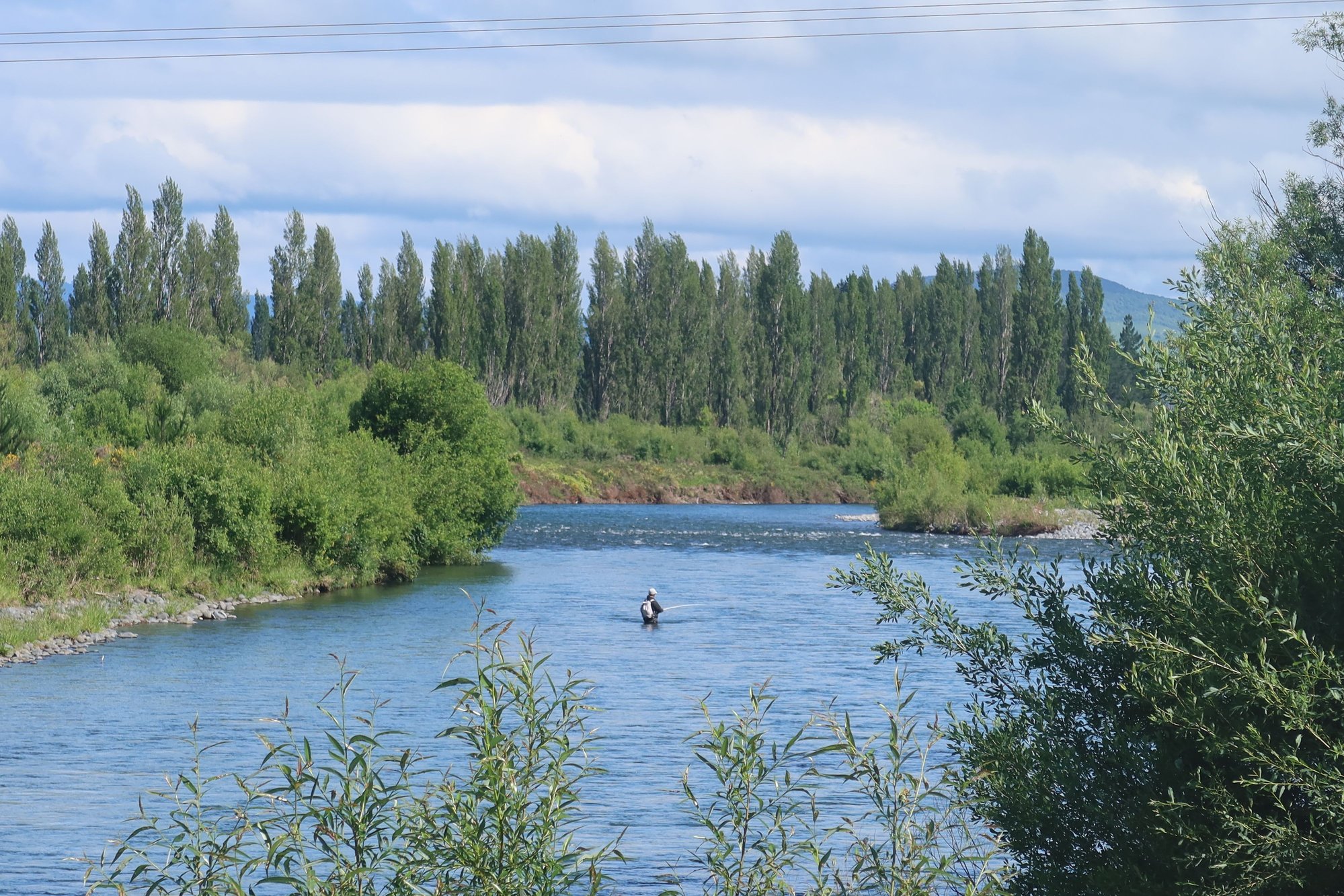
Tongariro River
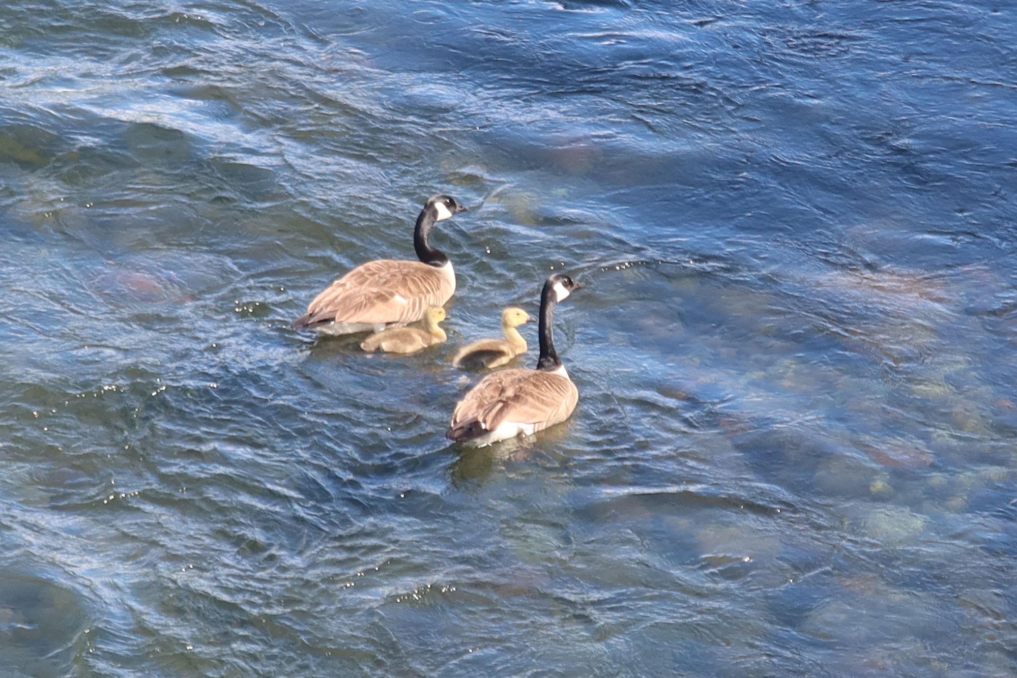
Whio or Blue Ducks
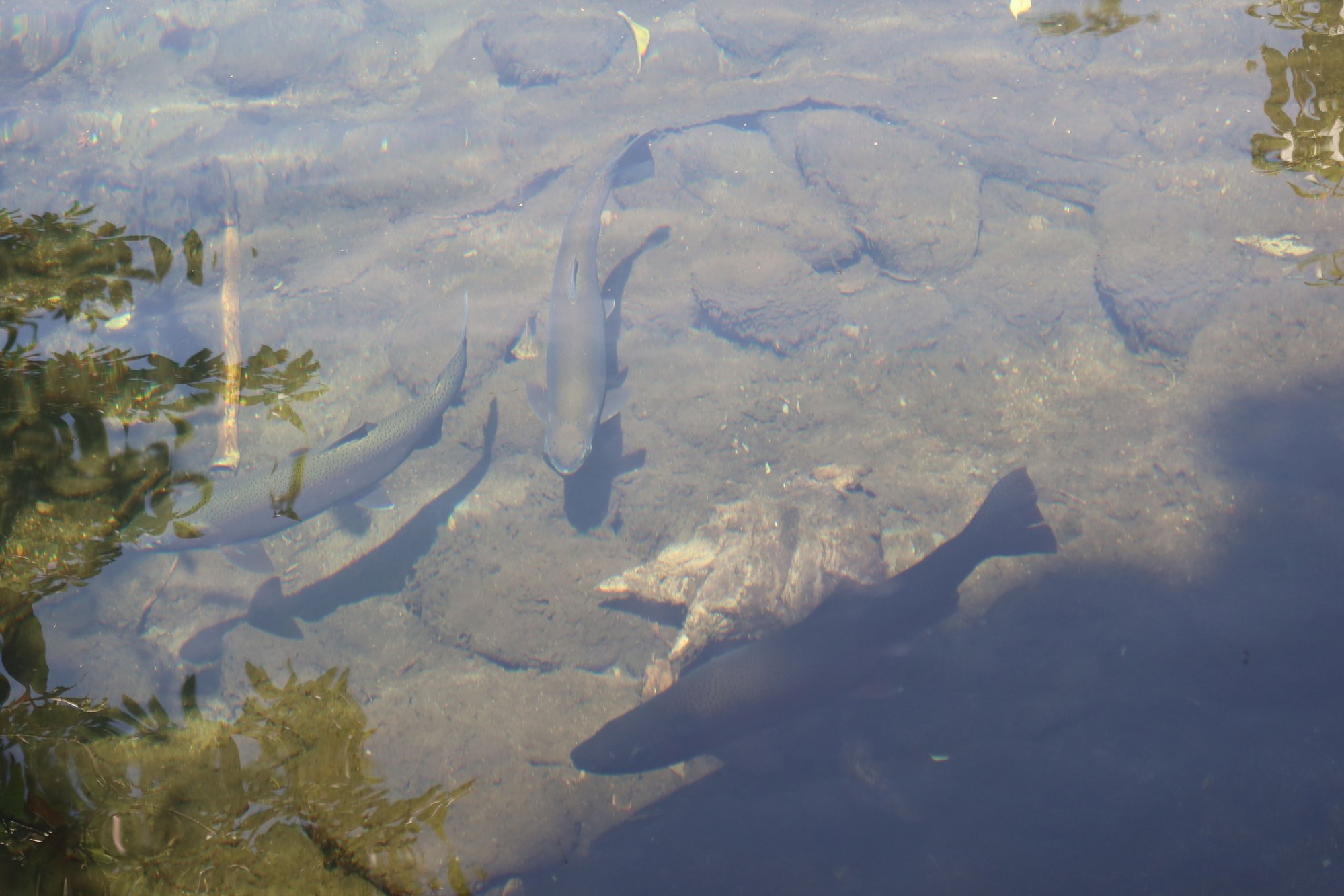
Trout

Dairy Farm
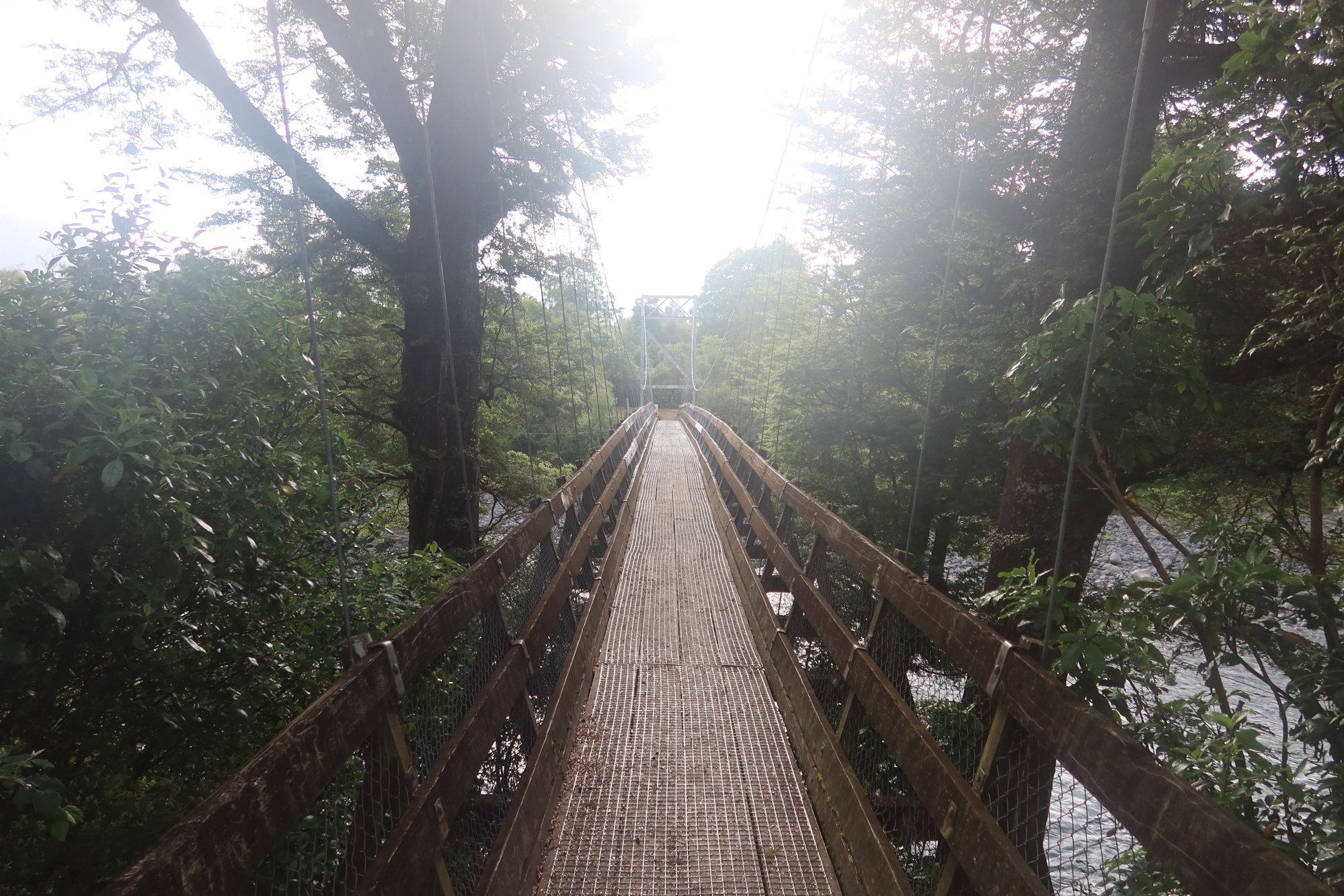
One of Two Swing Bridges over Tongariro River
A Lazy Day by the River
We intentionally booked an extra night than we really need at Tongariro Lodge, to give us an extra day in case the weather yesterday was bad enough for us to push the Tongariro Alpine Crossing to today. However, with the weather today similar to yesterday, we decided to proceed as planned. As such, what was a backup day became our recouperation day – from yesterday’s hike.
Today was a lazy day for us. We slept in, ate breakfast, and then took a stroll along the Tongariro River by our lodge. From there, we accessed the Tongariro River Trail on foot. The Tongariro River Trail is just shy of 14 kilometers, hugging the banks of the trout-filled Tongariro River. On one side the river runs close to local homes, and on the other it abuts dairy farms. Most of the walk was in the forest, with river views in certain sections. We saw people flyfishing for trout on the fast-flowing river as well as a few rare whio or blue ducks.
Along the way is the Tongariro National Trout Center, a museum, aquarium, and hatchery.
Tongariro River
Whio or Blue Ducks
Trout
Dairy Farm
One of Two Swing Bridges over Tongariro River

