264 Best Sights in Alberta, Canada

Background Illustration for Sights

We've compiled the best of the best in Alberta - browse our top choices for the top things to see or do during your stay.

Athabasca Glacier

Fodor's choice
ATHABASCA GLACIER, ALBERTA - AUGUST 1 - Ice Explorer Ride at Athabasca Glacier in Alberta, Canada on August 01, 2014. Thousands of people come every year to do Ice Explorer Ride at the Glacier
Lissandra Melo / Shutterstock

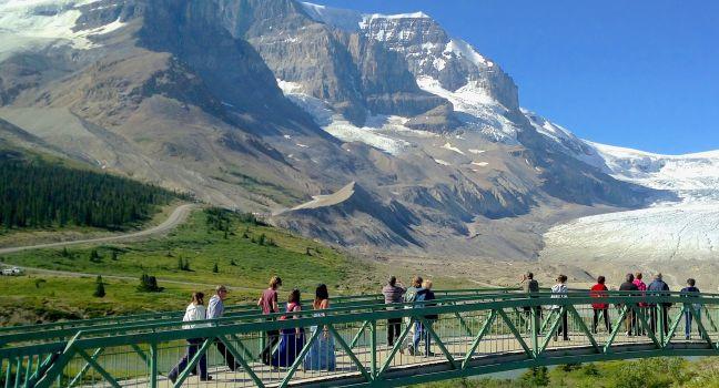
The glacier is a 7-km (4½-mile) tongue of ice flowing from the immense Columbia Icefield almost to the Icefields Parkway. A century ago, the ice flowed over the current location of the highway; signposts depict the gradual retreat of the ice since that time. Several other glaciers are visible from here; they all originate from the Columbia Icefield, a giant alpine lake of ice covering 325 square km (125 square miles). Its edge is visible from the highway. You can hike up to the toe of the glacier, but venturing farther without a trained guide is extremely dangerous because of hidden crevasses.

Athabasca Glacier Ice Walks ( 800/565–7547  www.icewalks.com) conducts three-, five-, and six-hour guided walks costing from C$130. Reserve a space at the Columbia Icefield Glacier Discovery Centre ( 866/506–0515  www.banffjaspercollection.com) or through Jasper Adventure Centre ( 780/852–5595 or 800/565–7547  www.jasperadventurecentre.com) in Jasper. You can also explore the glacier in an all-terrain Ice Explorer ( columbiaicefield.com) or a SHERP vehicle. The Glacier Skywalk is a glass-floored lookout with incredible views. Tickets for these experiences are also available at the Discovery Centre, as well as online.

Cave and Basin National Historic Site

Fodor's choice
BANFF, CANADA - JULY 29, 2014: Cave and Basin National Historical Site of Canada in the Town of Banff. It is the site of natural thermal mineral springs in Banff National Park.
Leonard Zhukovsky / Shuttestock

This site commemorates the birthplace of Canada's national parks system, which began with the protection of the Banff hot springs in 1885. You'll find restored historic buildings, a plaza, and splendid interpretive displays about Banff and the country's other national parks. An interpretive trail explains the area's geology, plant life, wildlife, and history. While walking past the cave's pools, keep an eye out for the park's most endangered species: the Banff Springs snail, which makes its home in the warm mineral waters, cannot be found anywhere else in the world. Children under age 17 enter the site for free, and combo tickets that include admission to Banff Upper Hot Springs are available.

Peyto Lake Lookout

Fodor's choice
Peyto Lake and Bow Summit in Banff National Park
oneword / Shutterstock

Named after Bill Peyto, a mountain guide, and early park warden of Banff National Park, Peyto Lake is one of the most beautiful lakes in the Canadian Rockies. The viewpoint for this brilliant turquoise glacier-fed lake is a short 20-minute stroll from the parking area just off the Icefields Parkway. At the lookout, you'll get a view of Peyto Lake, Peyto Glacier, and the Mistaya Valley. Interpretive signage along the trail explains its history and provides information about flora and fauna in the area. The lookout is accessed at Bow Pass, the highest point on the Icefields Parkway; it's wheelchair accessible from the upper parking lot that tour buses use.

Icefields Pkwy. (Hwy. 93), Banff National Park, AB, Canada

Something incorrect in this review?

Recommended Fodor's Video

Icefields Parkway

Fodor's choice
Scenic Views of the Icefields Parkway in winter, Banff National Park Alberta Canada
BGSmith / Shutterstock

Powerfully rugged mountain scenery, glaciers, waterfalls and icefalls, and wildlife: the Icefields Parkway reveals all of these and more as it snakes its way along the 230 km (143 miles) connecting Banff National Park with Jasper National Park. It is an absolute highlight of the Canadian Rockies.

You could drive this winding road in three to four hours, but your trip will more likely take a full day when you add in stops. The road rises to near the tree line at several points, and the weather can be chilly and unsettled at these high elevations, even in midsummer, so it's a good idea to bring warm clothing along. Only one gas station, open seasonally, operates on the parkway, so check your car's gas gauge before setting out.

Elk, moose, deer, and bighorn sheep are fairly common, and occasionally bears and mountain goats come into view. In summer, alpine wildflowers carpet Bow Pass and Sunwapta Pass. The most dramatic scenery is in the northern end of Banff National Park and the southern end of Jasper National Park, where ice fields and glaciers become common on the high mountains flanking the parkway. (Ice fields are massive reservoirs of ice; glaciers are the slow-moving rivers of ice that flow from the ice fields.) Scenic overlooks and signposted hiking trails abound along the route.

Cavell Meadows Loop

Fodor's choice

This moderately steep 8-km (5-mile) trail will take four to six hours. Into early summer the upper section is still covered in snow and not recommended, but from mid-July to mid-August you can enjoy the carpet of wildflowers. There's also an excellent view of the Angel Glacier. Moderate.

Cavell Rd., Jasper National Park, AB, Canada

Something incorrect in this review?

Crypt Lake Trail

Fodor's choice

Awe-inspiring and strenuous, this 17.2-km (11-mile) round-trip trail is one of the most stunning hikes in the Canadian Rockies. Conquering the trail involves taking a boat taxi across Waterton Lake, climbing 700 meters (2,300 feet), crawling through a tunnel nearly 30 meters (100 feet) long, and scrambling across a sheer rock face. The reward, and well worth it: views of a 183-meter (600-foot) cascading waterfall and the turquoise waters of Crypt Lake. This hike was completely untouched by the wildfires of recent years. Difficult.

Crypt Lake Trailhead, Waterton Lakes National Park, AB, Canada

Something incorrect in this review?

Dinosaur Provincial Park

Fodor's choice

Dinosaur Provincial Park encompasses 73 square km (28 square mi) of Canada's greatest badlands, as well as prairie and riverside habitats. A United Nations World Heritage Site, the park contains some of the world's richest fossil beds—dating as far back as 75 million years—including many kinds of dinosaurs. Much of the area is a nature preserve with restricted public access. Self-guided trails weave through different habitats, and a public loop road leads to two outdoor fossil displays. The Royal Tyrrell Museum Field Station has ongoing fossil excavations. Interpretive programs run daily from mid-May to early September and weekends until mid-October, but many require tickets; call for reservations. You should allow at least two full days for an in-depth experience. The campground has a food-service center.

Frank Slide Interpretive Centre

Fodor's choice

Overlooking the devastation of one of Canada's deadliest rockslides, the Frank Slide Interpretive Centre tells the tale of the night Turtle Mountain crumbled and 110-million metric tons of limestone crushed the town below. You can wander through interpretive displays and listen to the stories of survivors. Outside the museum is an overlook and an interpretive hiking trail that winds through the rubble.

2325 153 St., AB T0K 0E0, Canada
403-562–7388
Sight Details
C$15
Closed Mon. early Sept.–mid-May

Something incorrect in this review?

Highwood Pass

Fodor's choice

At 2,227 meters (7,310 feet), this high mountain pass along Highway 40 is the highest paved road pass in Canada. It's a beautiful driving route with stunning mountain scenery and superlative hiking trails and other sites just off the top of the pass. Since the pass is located right at the tree line, this is one of the most accessible high alpine areas in the Rockies. Near the summit, you'll find the Highwood Meadows Trail, a 0.6-km (0.4-mile) accessible interpretive trail that will take you through a fragile alpine meadow. This road over Highwood Pass is closed to motor vehicles from December through mid-June. Early June is a great time for cyclists to enjoy the route without the worry of encountering motor vehicles. Watch for elk, deer, moose, bighorn sheep, and grizzly and black bears as you traverse this pass.

Johnston Canyon Trail

Fodor's choice

Rushing water has carved a path through this must-see limestone canyon. The first 1.1 km (0.7 mile) is a paved walkway that leads to the 10-meter (33-foot) Lower Falls. From here, a slightly more rugged 2.7-km (1¾-mile) trail leads to the nearly 30-meter (100-foot) Upper Falls and a 5-km (3-mile) trail runs to the Ink Pots—six green pools filled with spring water. It takes four to five hours round-trip to complete. Moderate.

Banff National Park, AB, Canada

Something incorrect in this review?

Maligne Lake Road

Fodor's choice

Scenic Maligne Lake Road was built along the glacier valley that runs between the Maligne and Elizabeth mountain ranges. Along the 44-km (27-mile) drive to Maligne Lake, you'll see spectacular mountain scenery, other blue lakes, and the fast-flowing Maligne River. Highlights along the way also include Maligne Canyon and Medicine Lake. This drive takes you through one of the best places to spot wildlife, especially at dusk and dawn. Look for elk, moose, bighorn sheep, white-tail deer, and grizzly and black bears.

Maligne Lake Rd., Jasper, AB, Canada

Something incorrect in this review?

Mount Edith Cavell

Fodor's choice

The Jasper area's highest mountain stands 3,363 meters (11,033 feet) tall. Showing its permanently snow-clad north face to the town, the peak was named for a World War I British nurse who stayed in Belgium to treat wounded Allied soldiers after Brussels fell to the Germans and was subsequently executed for helping prisoners of war escape. The mountain is arguably the most spectacular site in the park reachable by car. From Highway 93A, a narrow, winding 14½-km (9-mile) road (often closed mid-October to late June) leads to a parking lot at the mountain's base. Trailers aren't permitted on this road, but they can be left at a separate parking lot near the junction with 93A. Several scenic lookouts along the route offer access to trails leading up the Tonquin Valley, one of the premier backpacking areas.

Off Hwy. 93A, Jasper National Park, AB, Canada

Something incorrect in this review?

Path of the Glacier Trail

Fodor's choice

This must-do 1.6-km (1-mile) trail only takes about an hour. The kid-friendly path, paved at the start, runs across a rocky landscape once covered in glacial ice. Eventually you come to a viewpoint overlooking Cavell Pond, which is fed by Cavell Glacier. Small icebergs often float in the water. The view across the valley takes in Angel Glacier, resting her wings between Mount Edith Cavell and Sorrow Peak. Easy.

Cavell Rd., Jasper National Park, AB, Canada

Something incorrect in this review?

Ptarmigan Cirque

Fodor's choice

Explore the Highwood Meadows Interpretive Trail before you cross Highway 40 to begin the Ptarmigan Cirque trail. The trail leads to a high alpine meadow with incredible views of the surrounding mountains. This hike is popular with wildflower enthusiasts, especially in early to mid-July when glacier lilies blossom shortly after the snow melts. In late July to early August, more than 80 different species of wildflowers might be seen in the meadows. The hike is also popular in autumn when the larch trees turn golden before dropping their needles. The 4.5-km (2.8-mile) trail has 225 meters (700 feet) of elevation gain. Moderate.

Highwood Meadows Day Use Area, AB, Canada

Something incorrect in this review?

Remington Carriage Museum

Fodor's choice

This unique museum houses the largest collection of horse-drawn vehicles in North America with more than 330 carriages, buggies, wagons, and sleighs. The nucleus of the collection, some 48 carriages, was donated by Don Remington, a local Cardston resident who restored and collected horse-drawn vehicles. Carriage rides are offered during the summer months for an extra charge.

Studio Bell/National Music Centre

Downtown Fodor's choice

This 160,000-square-foot building resonates with the sounds of music and activity, drawing visitors up through five floors of acoustically and visually distinct exhibition, performance, and gallery spaces. You can unleash your inner rock star by jamming out on the tools of the trade, and build and test instruments made from everyday objects. It’s also home to a number of attractions, including the Canadian Music Hall of Fame, the Canadian Songwriters Hall of Fame, and the Canadian Country Music Hall of Fame Collection.

Xplorer Program

Fodor's choice

Year-round, the park offers the Xplorer Program for kids age 6 to 11. Pick up an Xplorer Booklet at one of the park's visitor centers. Kids who complete at least six of the booklet's 22 activities receive a souvenir.

Lake Minnewanka Scenic Drive

Lake Minnewanka in Banff
Ray Yang / Shutterstock

It's easy to spend the day along this 25-km (15-mile) loop. Traveling clockwise, you can explore Lower Bankhead and Upper Bankhead, an abandoned coal mine and mining community. Just 3 km (2 miles) farther you come to Lake Minnewanka, the park's largest lake. Boat and fishing rentals are available. Still farther along are more lakes and picnic areas.

Lake Minnewanka Scenic Dr., Banff National Park, AB, Canada

Something incorrect in this review?

100 Street Funicular

Downtown

A fun and funky way to get from Downtown to the North Saskatchewan River Valley, this 48-second ride in a glass-walled elevator will transport you to a promenade where you can have a picnic or read a book. Carry on to the Frederick G. Todd Lookout if you want unobstructed views of the river valley. There’s also a cool set of stairs with built-in benches if you prefer to descend under your own power.

Abraham Lake

Alberta's largest reservoir is beautiful in every season, but it has become Instagram-famous in winter when bubbles freeze in the ice---pockets of methane gas freeze in layers that coat the lake. Methane gas bubbles are formed when bacteria breaks down organic matter at the bottom of the lake. It’s a phenomenon that's found in other Rocky Mountain lakes, but it’s more visible in Abraham Lake because high winds tend to keep the ice clear of snow; January and February are peak months to view the bubbles. The man-made lake was created in 1972 with the construction of the Bighorn Dam. The lake has a surface area of 53.7 square km (20.7 square miles). Although the lake is man-made, it still has the turquoise blue color of other Rocky Mountain Lakes. Watch for bighorn sheep, black bears, and other wildlife nearby.

Abraham Lake, Bighorn Backcountry, AB, Canada

Something incorrect in this review?

Adams Creek Fire Lookout

The steep 36.7-km (22.8-mile) round-trip hike to Adams Creek Fire Lookout from the Big Berland River staging area makes a nice overnight expedition in Willmore Wilderness Park. The trail has 1,369 meters (4,491 feet) of elevation gain. Difficult.

Big Berland River Staging Area, AB, Canada

Something incorrect in this review?

Akamina Parkway

Take this winding, 16-km (10-mile) road up to Cameron Lake, but drive slowly and watch for wildlife: it's common to see bears along the way. At the lake you will find a relatively flat, paved, 1.6-km (1-mile) trail that hugs the western shore and makes a nice walk. Bring your binoculars. Grizzly bears are often spotted on the lower slopes of the mountains at the far end of the lake.

Cameron Lake, Waterton Lakes National Park, AB, Canada

Something incorrect in this review?

Alberta Provincial Police Barracks

This unique museum is housed in the original Alberta Provincial Police (APP) barracks building. The APP was created during prohibition (1916–1924) to deal with "rumrunners" who were illegally importing alcohol from the United States and British Columbia. The museum tells the story of this police force, a murder, and the trial of the only woman who was ever executed in Alberta.

7809 18 Ave., Coleman, T0K 0M0, Canada
403-563–5434
Sight Details
C$10
Closed Sept.–mid-May

Something incorrect in this review?

Allstones Lake

This moderately strenuous 13-km (8.1-mile) round-trip hike leads to a lovely alpine lake with beautiful views along the way. If you climb to the top of the peak near the lake you'll have a stunning view of Abraham Lake and the surrounding mountains. Moderate.

Abraham Lake, Bighorn Backcountry, AB, Canada

Something incorrect in this review?

Angel Glacier

Stretching along the north face of Mount Edith Cavell, this glacier was named because it looks like an angel with wings. The best views of the glacier can be seen on the Cavell Meadows Hike.

Angel Glacier, Jasper National Park, AB, Canada

Something incorrect in this review?

Arethusa Cirque

Just south of Ptarmigan Cirque, this 5-km (3.1-mile) loop trail actually has more larches than its better-known neighbor. The trail begins by passing through a forested area and then opens up into a wide meadow. There's 274 meters (899 feet) of elevation gain, but it's a relatively easy hike. Easy.

Arethusa Cirque, AB, Canada

Something incorrect in this review?

Art Gallery of Alberta

Downtown

Located across from City Hall, this exquisite building is wrapped with silver ribbons to reflect the importance of the northern lights and the North Saskatchewan River to Edmonton’s identity and culture. With several galleries spread across three floors, AGA has welcomed exhibits of some of the greats including Degas, the Dutch masters, and an Andy Warhol retrospective. The in-house collection primarily focuses on Canadian abstract painting and sculpture since the 1950s, and the Children’s Gallery on the main floor provides an interactive experience for families to immerse themselves in art. Don't miss the great city views from the rooftop patio.

2 Sir Winston Churchill Sq., Edmonton, AB, Canada
780-422--6223
Sight Details
C$14
Closed Mon. and Tues.

Something incorrect in this review?

Astoria Valley Viewpoint

This pull-off along Cavell Road offers views of the Astoria Valley and the glaciers at its head.

Cavell Rd., Jasper National Park, AB, Canada

Something incorrect in this review?

Athabasca Day Use Site

This large area has a shelter and is ideal for family reunions because it can be reserved ahead for a fee of C$149.25. It has beautiful views of the river and mountains.

Athabasca Day Use Site, Jasper National Park, AB, Canada
780-852–6176

Something incorrect in this review?

Athabasca Falls

At 23 meters (75 feet), these falls are not the highest in the Canadian Rockies, but they are the most powerful. The Athabasca River carries more water than any other in the Rocky Mountains, and all of it is funneled over this cascade and into a narrow gorge, creating a powerful surge. The falls are especially dramatic in late spring and early summer when the river is at its highest. Trails and overlooks provide good viewpoints. Do not climb past the guardrails: the rocks and vegetation are very slippery, and people have died trying to get a photo of themselves standing closer to the falls.

Athabasca Falls, Jasper National Park, AB, Canada

Something incorrect in this review?