68 Best Sights in Banff National Park, Alberta

Cory Pass Loop Trail

Although those who hike this 13-km (8-mile) trail are rewarded with awesome views, it's one of the park's most strenuous treks, requiring about six hours to complete, and so it's recommended only for experienced hikers who can trace a difficult route. The return trip loops around Mount Edith Clavell and descends the Edith Pass Trail. Difficult.

Banff National Park, Alberta, Canada

Crescent Falls

Crescent Falls is a 27-meter (89-foot) two-tiered waterfall that is beautiful in every season. The turnoff for Crescent Falls Provincial Recreation Area is 22 km (13.7 miles) west of Nordegg on Highway 11. The gravel access road is 6 km (3.7 miles) long and there's a lookout point partway along the road where you get great views of the Bighorn Gorge. There's also a 29-site campground near the falls.

Crescent Falls, Bighorn Backcountry, Alberta, Canada

Crowfoot Glacier and Crowfoot Mountain

About 34 km (21 miles) northwest of Lake Louise, the Crowfoot Glacier is one of the first glaciers you see on the Icefields Parkway. Situated on the northeastern side of Crowfoot Mountain, the glacier overlooks Bow Lake---if you stop at the Bow Lake pullout, you can see the glacier and mountain on the other side of the lake. Runoff from the glacier flows into the Bow River, which runs from Banff National Park to the City of Calgary and beyond to the prairies.

Crowfoot Glacier, Banff National Park, Alberta, Canada

Recommended Fodor's Video

Discovery Trail and Marsh Trail

On a hillside above the Cave and Basin National Historic Site, this 0.8-km (½-mile) boardwalk takes you past the vent of the cave to a spring flowing out of the hillside. Interpretive signage explains the geology and history of the cave and basin. Follow the Marsh Trail to observe the birdlife and the lush vegetation fed by the mineral water. Along the boardwalk are telescopes, benches, and interpretive signage as well as a bird blind on the marsh itself. Wheelchairs have limited access to the boardwalk. Easy.

Fairmont Banff Springs

Banff's architectural showpiece and a National Historic Site, this hotel south of downtown is easily recognized by its castlelike exterior. Heritage Hall, a small museum above the Grand Lobby, has exhibits describing the hotel's history. On guided tours you can learn additional details about the local area, the hotel's grand opening in 1888, the 1920s fire that destroyed the original structure, subsequent construction, and the many illustrious guests who have stayed here.

405 Spray Ave., Banff National Park, Alberta, T1L 1J4, Canada
403-762–2211
sights Details
Rate Includes: Hotel and museum free; tours free for hotel guests, C$15 for nonguests

Fenland Trail

It will take about an hour round-trip to walk the 2-km (1-mile) trail that slowly changes from marsh to dense forest. Watch for beavers, muskrat, and waterfowl. The trail is popular with joggers and cyclists. Easy.

Fireside

This area has picnic tables and toilets nearby.

Hoodoos Viewpoint

A scenic view of the rocky spires known as hoodoos can be seen from this viewpoint 3.2 km (2 miles) up Tunnel Mountain Road. If you want to get closer to the hoodoos, you can hike along the trail that leaves from the viewpoint. 

Hoodoos Viewpoint, Banff, Alberta, T1L 1K2, Canada

Johnson Lake

A family-friendly 3.1 km (1.9 mile) loop trail circles this lake passing some of the oldest Douglas fir trees in Alberta. The lake is in the montane zone of the park and is a good place to spot wildlife. There are lovely views of Mount Rundle and Cascade Mountain and picnic tables if you want to linger. Because the lake is smaller and somewhat sheltered, it tends to have smoother water for paddling. 

Johnson Lake, Banff National Park, Alberta, Canada

Kananaskis Country

Three provincial parks make up the 4,200-square-km (1,600-square-mile) recreational region known as Kananaskis Country, whose northern entrance is 26 km (16 miles) southeast of Canmore. The area includes grand mountain scenery, and though it's not quite a match for that in the adjacent national parks, Kananaskis allows some activities the parks prohibit, including snowmobiling, motorized boating, and off-road driving. There are also spectacular cross-country and mountain-biking trails.

The main route through Kananaskis Country is Highway 40, also known as the Kananaskis Trail. It runs north–south through the front ranges of the Rockies. Only the northern 40 km (25 miles) of the road remain open from December to mid-June, in part because of the extreme conditions of Highwood Pass (at 7,280 feet, the highest drivable pass in Canada), and in part to protect winter wildlife habitats in Peter Lougheed Provincial Park. Highway 40 continues south to join Highway 541 west of Longview. Access to East Kananaskis Country, a popular area for horseback trips, is on Highway 66, which heads west from the town of Priddis.
Lake Agnes Trail

Winding north of Lake Louise, this 7-km (4½-mile) trail has stunning views of Lake Agnes and Mirror Lake. The trail passes through an old-growth forest and comes up the right side of a waterfall before ending at a teahouse where you can stop for dessert. It will take at least four hours to complete this trail. Moderate.

Lake Louise, Alberta, Canada

Lake Louise

This is one of the most photographed spots in the park. In summer, you can walk beside the lake and enjoy the nearby hiking trails. Winter offers skating on the ice and sleigh rides. The lakeside Fairmont Château Lake Louise hotel is a departure point for several short, moderately strenuous, well-traveled hiking routes, including the popular 3-km (2-mile) trail to Lake Agnes. The tiny lake hangs on a mountain-surrounded shelf that opens to the east with a bird's-eye view of the Beehives and Mount Whitehorn. The teahouse (cash only) by Lake Agnes serves soups, sandwiches, and snacks. In 2021, Parks Canada implemented a mandatory parking fee for the Lake Louise parking lot mid-May to mid-October. Parks Canada also operates a shuttle bus service during peak season. Bus tickets must be booked in advance. 

Buy Tickets Now
111 Lake Louise Dr., Lake Louise, Alberta, T0L 1E0, Canada
403-522–3511
sights Details
Rate Includes: parking C$11.70, shuttle C$8

Lake Louise Sightseeing Gondola

Hop on the gondola to an alpine plateau for a stunning view that includes more than a dozen glaciers. The deck of the viewing platform is a good place to enjoy an ice-cream cone, a cold drink, or a picnic lunch, or you can buy a ticket that includes breakfast or lunch at the lodge near the gondola's base. Several easy hikes are accessible from the top of the lift and guided interpretive walks (45 minutes) take place several times daily. The Wildlife Interpretive Centre is a 5–10 minute walk from the top of the gondola and it has programming, life-size animal displays, and information about local wildlife. It's common to see grizzly bears from the safety of the gondola.

1 Whitehorn Rd., Banff National Park, Alberta, T0L 1E0, Canada
403-522–3555
sights Details
Rate Includes: C$49.99 ride only, C$54.99 with breakfast, C$59.99 with lunch, C$74.99 with gourmet dinner, C$16.95 for guided hiking tour

Lake Louise Visitor Centre

Stop here to get maps and information about area attractions and trails. Parks Canada staff can assist with up-to-date park information. Banff and Lake Louise Tourism staff can provide information on area accommodations and amenities, and you can purchase educational books and other materials.

Lake Magog

Beautiful glacier-fed Lake Magog sits in front of Mt. Assiniboine and it is the site of most of the park's facilities and trailheads. The two main hiking routes into the park lead to this lake. An easy 3.2-km (2-mile) trail around the west shore of the lake offers wonderful views of Mt. Assiniboine reflecting off the lake surface.

Mt. Assiniboine Provincial Park, British Columbia, Canada

Lake Minnewanka Picnic Area

A popular spot, this area has picnic shelters, tables, flush toilets, fire rings, and fireplaces. Hike, rent a boat, or try your luck at fishing.

Lake Minnewanka Scenic Drive

Lake Minnewanka Scenic Drive
Ray Yang / Shutterstock

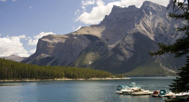
It's easy to spend the day along this 25-km (15-mile) loop. Traveling clockwise, you can explore Lower Bankhead and Upper Bankhead, an abandoned coal mine and mining community. Just 3 km (2 miles) farther you come to Lake Minnewanka, the park's largest lake. Boat and fishing rentals are available. Still farther along are more lakes and picnic areas.

Lake Minnewanka Scenic Dr., Banff National Park, Alberta, Canada

Mistaya Canyon

A 1.8-km (1.1-mile) loop trail leads from a well marked highway pullout to a footbridge over a deep winding slot canyon where you can view the Mistaya River swirling far below. The highway pullout is 74 km (46 miles) northwest of Lake Louise. 

Icefields Pkwy. (Hwy. 93), Banff National Park, Alberta, Canada

Moraine Lake

One of the most beautiful lakes in the Canadian Rockies is the setting for this picnic area near the village of Lake Louise. The site has two kitchen shelters, a few tables, and toilets.

Moraine Lake

Set in the Valley of the Ten Peaks, 11 km (7 miles) south of Lake Louise, this beauty is a photographic highlight of the park thanks to reflections of the snow-clad mountaintops that rise abruptly around it. It's also a major stop for tour buses and is popular with hikers and canoeists, too, so visit early or late in the day to avoid crowds. Moderate hiking trails lead from the lodge at Moraine Lake into some spectacular alpine country. During peak times (larch season), Parks Canada operates a shuttle service from the hamlet of Lake Louise to Moraine Lake.

Mt Norquay Scenic Drive

The highlight of this 6½-km (4-mile) route is the viewpoint over Banff from near the top. Bighorn sheep and mule deer are often sighted along the twisting road. Trailheads at the top lead to Stoney Squaw Summit and Cascade Amphitheatre.

Niblet and Nublet

This moderately difficult 3-km (1.9-mile) hike offers stunning views of Sunburst, Elizabeth, Cerulean, Magog, and Wedgewood Lakes as well as Sunburst Peak and Mount Assiniboine. The hike begins at the lodge and climbs up to a ridge known as the Niblet and then continues on to the summit of the Nublet. The total elevation gain is 350 meters (1,148 feet). Moderate. 

Assiniboine Lodge, Mt. Assiniboine Provincial Park, British Columbia, Canada

Norquay Sightseeing Chairlift

Great views of the Bow Valley, Banff Townsite, and surrounding mountain peaks can be enjoyed from the top of the Norquay chairlift. The ride up takes 10 minutes. An interpretive path, a viewpoint, and the historic Cliffhouse Bistro, where you can have lunch, dinner, or drinks, are at the top. 

Quarry Lake Park

One of Canmore's most popular recreational areas, the lake has a small sandy beach and a swimming area fed by an underground mountain spring. There are picnic tables and washrooms, and about 5 km (3 miles) of trails are nearby. The picnic area is adjacent to an off-leash dog park.
Canmore, Alberta, Canada
sights Details
Rate Includes: Free, Daily 7 am–11 pm

Rockpile Trail - Moraine Lake Viewpoint

This short 0.8 km (0.5 mile) trail leads up stairs that have been built into rocks and takes you to the top of a rock pile to enjoy an incredible view of Moraine Lake. There are a variety of lookout points from the top of the rock pile, but it's important to stay on the trail, as walking over rocks and logs off-trail can be dangerous. Easy.

Moraine Lake, Banff National Park, Alberta, Canada

Saskatchewan River Crossing

Located at the junction of the Icefields Parkway (Highway 93) and Highway 11, this is the only place that offers basic services (gas, convenience store, restaurant, and lodgings) between the hamlet of Lake Louise and the town of Jasper.
Icefields Pkwy. (Hwy. 93), Banff National Park, Alberta, Canada

Siffleur Falls

Siffleur Falls is one of the most popular trails in Bighorn Country. The relatively easy 8-km (5-mile) round-trip hike will take you across a suspension bridge, a boardwalk, and along a deep gorge with several viewing points before you reach beautiful Siffleur Falls. The trail is wide and relatively easy with only about 100 meters (328 feet) of elevation gain. It's a good hike for families, but it cannot accommodate strollers or wheelchairs. Ambitious hikers can continue on past the first falls to see two more waterfalls at 6.2 km (3.9 miles) and 6.9 km (4.3 miles) one-way. This trail can be busy in summer. Easy. 

Siffleur Falls, Bighorn Backcountry, Alberta, Canada

Sulphur Mountain Trail

This well-maintained trail crisscrosses underneath the gondola on Sulphur Mountain and climbs from the parking lot to the summit. You can hike up and take the gondola down, but you should check schedules first. A restaurant and cafeteria are located at the summit along with a viewing platform and interpretive signage. Allow four hours to hike the trail round trip. Difficult.

Banff National Park, Alberta, Canada

Sulphur Mountain Weather Station & Cosmic Ray Station

The small, stone weather station, a recognized heritage building, sits on top of an exposed ridge at the peak of Sulphur Mountain. It was built in 1902 and Norman Sanson was in charge of the weather station from 1902--1945. He summited the peak more than a thousand times in all seasons and his weather reports were published in the Banff newspaper under the pseudonym "Seer Altitudinous." He was 84 years old when he retired from the job and the peak was renamed Sanson's Peak in his honor in 1948. Nearby is a concrete foundation and a bronze plaque recognizing Sulphur Mountain Cosmic Ray Station National Historic Site. Between 1957 and 1978, geophysicists studied cosmic rays and space particles entering the atmosphere from the station on top of Sulphur Mountain. Today you can hike up as Sanson did, or ride the gondola.

Sulphur Mountain Weather Station, Banff National Park, Alberta, Canada

Sunburst, Cerulean and Elizabeth Lakes

It's a beautiful and relatively easy hike along the Sunburst Trail from Assiniboine Lodge to Elizabeth Lake. The Sunburst Trail branches off the Lake Magog Trail just before the campground. The trail goes along the shore of Sunburst Lake past Lizzie Rummel's log cabin to Cerulean Lake and then climbs a ridge where you have the option of turning east to hike 1 km (0.6 mile) up to the Niblet or continuing straight to Elizabeth Lake. The hike is 4.4 km (2.7 miles) one-way to Elizabeth Lake without adding the Niblet and Nublet. You can do it in a loop by continuing on from Elizabeth Lake and turning east along the shore of Cerulean Lake. Easy.

Assiniboine Lodge, Mt. Assiniboine Provincial Park, British Columbia, Canada