Biking
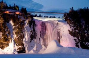
There are over 100 km (60 miles) of fairly flat, well-maintained bike paths on Québec City's side of the St. Lawrence River and a similar amount on the south shore. Detailed route maps are available through tourism offices. The best and most scenic of the bike paths are the one that follows the old railway bed in Lévis, accessible near the Québec-Lévis ferry terminal, and the one that follows the Saint-Lawrence River on the north shore, all the way to Montmorency Falls. Many parts of the regional network are now part of the province-wide Route Verte, a government-funded, 4,000-km-long (2,500-mile-long) circuit of long-distance bicycle paths and road routes.
Corridor des Cheminots. Ambitious cyclists can embark on the 22-km-long (14-mile-long) trail that runs from Québec City near Old Québec to the town of Shannon. It's a slow uphill on the way out—with the reward of an easier ride back. Québec City, Québec.
Côte-de-Beaupré. Paths along the beginning of the Beaupré coast, at the confluence of the St. Charles and St. Lawrence rivers, are especially scenic. They begin northeast of the city, at rue de la Vérendrye and boulevard Montmorency or rue Abraham-Martin and Pont Samson (Samson Bridge), and continue 10 km (6 miles) along the coast to Montmorency Falls. Québec City, Québec.
Mont-Ste-Anne. The site of the 1998 world mountain-biking championship and races for the annual World Cup has around 150 km (93 miles) of mountain-bike trails and an extreme-mountain-biking park. Québec City, Québec. 800/463--1568; www.mont-sainte-anne.com. C$15 trails only; C$43 unlimited access to ski lift and trails.