- ⁄
- Travel News
- ⁄
- National Parks •
- News
From hikes across ancient glaciers to lush rainforest treks, these are the 25 most beautiful U.S. national park hikes.
Sure, with 60 National Parks across the U.S. and U.S. territories, it’s no problem to find plenty of hikes with views that are sure to score likes on your Instagram. But with the popularity of national parks–more than 331 million visits were tracked last year–you’ll sometimes need to go off the beaten path to find the views you’ll remember for the rest of your life. While hiking aficionados will recognize some of the trails on this list, others are located in the least traveled, most remote areas of U.S national parks. But if you’ve got the desire, the stamina, and, most of all, a good pair of hiking shoes, we encourage you to consider adding these 25 trails to your National Park bucket list.
INSIDER TIPTrail difficulty is relative to other trails at the park; an easy trail in one park may be rated as moderate in another. Research the trail, terrain, and elevation before beginning any hikes.
Top Picks for You
Iceberg Lake Trail
This trail through alpine valleys ends at the stunning, sky blue Iceberg Lake, surrounded by 2,000-foot cliffs. Though this trail is popular, you should be able to find a quiet space to yourself if you start walking along the lake’s furthest edges. While the water may look refreshing, it’s extremely cold–after all, there are pieces of icebergs floating on it. Swimming is discouraged, though no one will stop you from dipping your toes in after this long but rewarding hike.
Expert level: 5/10 – Long but with very gradual climbs
Distance and Elevation Gain: 9.7 miles/1,200 feet
INSIDER TIPThanks to huckleberry bushes along the trails, this route is very popular for spotting grizzly bears. Make sure to carry bear mace and make noise around tight corners.
Tower Arch Trail
WHERE: Arches National Park, Utah
Utah’s Arches National Park is known for its stunning rock formations that lend the park its name, but it be can hard to find space to yourself with everyone scrambling (pun intended) to take photos of this Instagram-worthy park. So take the nine-mile drive out to the park’s more-remote northwest area and hike the short trail to Tower Arch. With a natural rock arch spanning 92 feet and views through it looking out onto the rest of the park, this less-popular trail offers all the beauty of this unique park’s most crowded trails–with a much smaller chance of a random hiker ruining your photos.
Expert level: 4/10 – Short but with a lot of up and down climbs
Distance and Elevation Gain: 3.4 miles/600 feet
INSIDER TIPThe road to the trailhead can get a bit washed out in rainy conditions; check with a ranger for current conditions before beginning the drive.
Recommended Fodor’s Video
The Boardwalk Loop
WHERE: Congaree National Park, South Carolina
This hike, though it’s really more of a walk, features an elevated boardwalk through old-growth swampland. Though the lush, green trees are beautiful in their own right, the trail really shines at night (literally!) when thousands of fireflies come out and fill the area. For photographers, the trail is exceptionally beautiful at sunrise, when both the boardwalk and cyprus trees take on golden early-morning hues. Wildlife like deer and wild pigs can also be seen in the area for those willing to sit silently for a few minutes You’ll definitely want mosquito repellant, especially in the summer months.
Expert level: 1/10 – Short and flat on a well-maintained boardwalk.
Distance and Elevation Gain: 2.4 miles/negligible gains
INSIDER TIPThis trail has numbered posts along the way that correspond to an informative guide. Download the guide in advance or pick one up at a visitor’s center before starting your walk.
The Hoh River Trail to Blue Glacier
If a rainforest hike is on your bucket list but you don’t have time to head to South America, head to the Hoh River Trail in Washington’s Olympic National Park. This backpacking trail runs through one of the U.S.’s few legitimate rainforests, and the views along the way are exactly what you’d imagine: massive, moss-covered trees; giant ferns, and flowing streams. Time seems to stand still in this abundantly green forest, which may make you think you’re in Jurassic Park, not Washington state. The Hoh Rainforest has also been described as the quietest place in the U.S., ideal for backpackers seeking solitude.
Expert level: 6.5/10 – Easy multi-day hiking for first-time backpackers
Distance and Elevation Gain: 32.8 miles/3,700 ft.
The Wonderland Trail
The Wonderland Trail’s sweeping valley and snow-capped mountain views may make hikers think they’ve stepped out of the U.S. and into the Alps. Though this hike can take up to 14 days, every day offers a different vista, as this trail passes through everything from glaciers to waterfalls to rocky canyons. Given the variety of this trail’s terrain, it requires savvy packing, as conditions may be wet and warm one day and dry and cold as you ascend two days later. It’s hard to pick one highlight of this stunning trail, though the wildflower viewing near the Indian Bar campsite is not to be missed.
Expert level: 9.5/10 – Extended hiking with constant elevation change
Distance and Elevation Gain: 93 miles/23,000 feet
Slaughter Canyon Cave
For hikers who prefer stalagmites to summits, this underground hike deep inside the Guadalupe Mountains goes past some of the largest cave rock formations in the world. Though New Mexico has no end of places to explore, the massive underground system at Carlsbad is certainly a must-do. Pictographs–evidence of Native American use–dot the walls of the cave, which is home to the Monarch, the tallest column in the entire cave system and one of the largest in the world. The Slaughter Canyon Cave can be visited by tour only, with advanced reservations recommended.
Expert level: 4.5/10 – A steep climb to the entrance and hot temperatures may turn off novice hikers
Distance and Elevation Gain: 2 miles/800 feet (approx)
INSIDER TIPIf you don’t feel up to the difficulty of the Slaughter Canyon Cave but are still feeling adventurous, the Lower Cave tour includes a descent by ladder into the cave system.
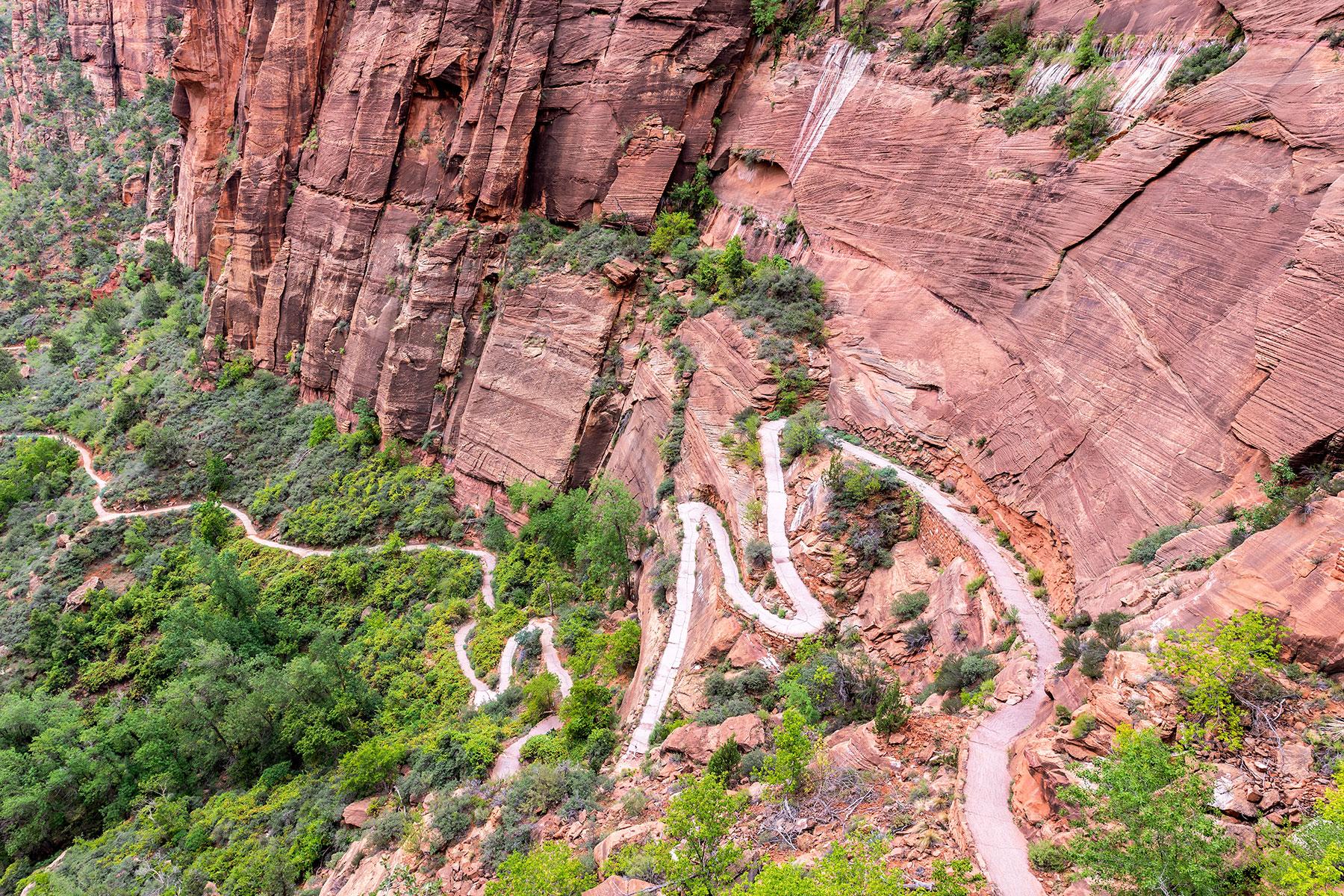
Angel’s Landing
WHERE: Zion National Park, Utah
Words like “stunning” don’t do this Utah hike justice, which leads to a pillar of rocks so high and steep that “only angels could land on it.” It’s one of the most famous hikes in the state, thanks to its 360-degree views of the entirety of Zion National Park’s red, orange, and yellow-tinted canyons. This hike should probably be skipped by hikers with a fear of heights, as the last 600 feet or so cross a thin ridgeline with steep drops in parts. Chains and guardrails are mounted along the way to make the hike a little less frightening.
Expert level: 6/10 – This short but steep hike is definitely a leg burner
Distance and Elevation Gain: 5 miles/1,488 feet
Tall Trees Trail
This trail takes hikers past the tallest redwood trees in the world, the scale of which can only be understood in person. Though the current tallest tree in the world isn’t viewable from his hike, it is in the same forest, where it’s protected from human impact. This hike exemplifies the best of California’s Lost Coast, with overgrown forests, winding paths, and almost no human development, aside from the occasional trail marker. With some trees topping out at close to 400 feet, “tall trees” may be an understatement.
Expert level: 3/10 – Short distance and even elevation changes
Distance and Elevation Gain: 3.5 miles/777 feet
INSIDER TIPTo hike this trail, you’ll need to get a permit in advance at a park visitor’s center; a gate blocks the road for non-permit holders.
Cadillac Mountain
WHERE: Acadia National Park, Maine
If you fancy the idea of being the first person in the country to view the sunrise, aim to summit Cadillac Mountain in October in Acadia National Park. This hike takes guests to the highest point on the North Atlantic seaboard and passes pink granite boulders, remnants of the last ice age. Taking the South Ridge Trail Loop towards the summit will take you past wildflower fields and small ponds, perfect for relaxing along the way. This trail can also be hiked (carefully) at night, for photographers seeking clear and bright shots of the milky way.
Expert level: 6.5/10 – May be too long and steep for non-experienced hikers
Distance and Elevation Gain: 7.5 miles/2,247 ft.
INSIDER TIPYou can also drive to the summit of Cadillac Mountain, though limited parking means you’ll need to get there very early to snag a spot.
Lost Mine Trail
As one of the highest trails in the park, the Lost Mine Trail is often several degrees cooler than other places in Big Bend, one of the country’s most remote national parks. Because of the Lost Mine Trail’s elevation, it also features fantastic views across not one but two countries, looking down into Mexico’s ecologically-rich Sierra del Carmen. Several rock outcroppings along the way provide space to rest while taking in the views, and since Big Bend is one of America’s least visited parks, you’ll probably have them to yourself.
Expert level: 5/10 – Appropriate for hikers prepared and in average shape
Distance and Elevation: 4.8 miles/1,000 feet
Sierra Point
Yosemite may be famous for well-known hikes like Half Dome or the waterfall-laden Mist Trail, but when it comes to beauty, it’s hard to beat the short-but-steep Sierra Point Lookout Trail. This trail–ecologist John Muir’s favorite, according to records from the early 1900’s–leads hikers to the only spot in the park where four of the Yosemite Valley’s five waterfalls can be seen at once. Photography aficionados might recognize these vistas, as many of the Ansel Adams photos that spurred international interest in Yosemite were taken from this partially hidden summit.
Expert level: 6/10 – Short but steep with difficulty wayfinding at times
Distance and Elevation: .7 miles/1,000 feet
INSIDER TIPThis trail is no longer maintained or marked on park maps due to a rockslide in the 1970s, but a quick scramble over the fallen rocks will lead hikers to the former trail.
Mt. Katmai Caldera
WHERE: Katmai National Park, Alaska
For expert hikers and alpinists only, the trek to the snow-covered Katmai Caldera involves glacier crossing over crevasses–significant ice-climbing experience is required. However, if you’ve got repelling gear and crampons just waiting to be used, this hike will make all others pale in comparison. Non-maintained backcountry camping huts along the way are open to the public (first-come, first-served) though it’s recommended that you not attempt this hike without a guide. Deep ash still remains from the massive 1912 volcanic explosion that formed the caldera. You’ll need to fly into Brooks Camp to begin the hike, though if water levels are high enough, you can occasionally arrive by boat from nearby King Salmon Village. The easiest way into The Valley of Ten Thousand Smokes, where this hike starts, is via bus through the park’s official tour concessioner, Katmailand, Inc.
Expert level: 10/10 – Hikers wishing to hike to the caldera need ice climbing gear and experience on glaciers and crevasses
Distance and Elevation: Various/4,000+ feet
Kalapana Lava Viewing Hike
The full fury of Mother Nature is always on display on this hike, where red-hot lava can be seen seeping into Hawaii’s blue ocean. Towards the end of the hike you’ll be able to trek across lava flows, so thick hiking shoes are a must. However, lava can be seen seeping out of the earth at various points throughout this hike, so there’s no need to push yourself across uneven terrain if you’d rather play it safe. Boat tours are also available for visitors wishing to see the lava without doing any hiking.
Expert level: 3/10 – Mostly flat, but a little long and bumpy for anyone with walking issues
Distance and Elevation: 8 miles/230 feet
INSIDER TIPAdventurous types who want a sight to remember can bike this trail at night to fully appreciate the orange and yellows of the flowing lava. Bring a headlamp.
The Narrows
WHERE: Zion National Park, Utah
Yes, Zion gets a second mention. This time, it’s for this hike through a stream, with massive canyon walls so tight on each side that hikers can touch both at the same time. Water levels vary throughout the year in this hike, but regardless of when you’re there, you should plan to get wet at least up to your knees. Though anyone can do this hike, shoes with good grip and a drybag are recommended, as it’s easy to slip on rocks, especially when crowded. Photographers will want to get here early in the morning when the light is softest. Though the Narrows is a relatively easy, flat hike, flash floods can turn this area very deadly, very quickly. Even if the weather looks clear, always check the forecast and postpone this hike if there’s any chance of rain.
Expert level: 3/10 – Flat, though the river that can be slippery in spots.
Distance and Elevation Gain: 1.8 miles/150 feet
INSIDER TIPIn the spring, when water temperatures are at their coldest, wetsuits can be rented at several outfitters outside the park.
Fairyland Loop
If you don’t know what a hoodoo is, you’ll know after crossing this spectacular hike’s eight miles of hoodoo-covered trails. These unique rock columns can be found throughout the trail, eventually culminating in “Fairyland Canyon,” a valley of staggeringly large and vast formations as tall as 150 feet. The colorful hoodoos are some of the brightest and most unusual in the park, giving the whole area an otherworldly feel. Because of this trail’s length and constant up and downs, it’s one of the least crowded hikes in the park.
Expert level: 7/10 – Constant ups and downs with some difficulty wayfinding
Distance and Elevation Gain: 7.5 miles/1,550 feet
North Kaibab Trail
Since only about 10 percent of Grand Canyon National Park’s visitor’s venture to the north rim, trails here are significantly less crowded. And as the least visited and most difficult trail on the north rim, the North Kaibab Trail offers a rare chance for solitude in one of the country’s most popular parks. Head out from the trailhead for not just scenic canyon views, but also waterfalls, caves, and plenty of impressive photo ops. Parts of this trail are blasted directly out of the surrounding limestone for a tunnel-esque feeling as you literally walk through the walls. “The Box”–a narrow section of the route that runs parallel to Bright Angel Creek–is an especially beautiful section of this route into the Grand Canyon.
Expert level: 8/10 – For experienced backpackers only
Distance and Elevation Gain: 28 miles/ 5,850 feet
INSIDER TIPLook for trail signs for Roaring Springs and Ribbon Falls along the way, two short side trips that offer a refreshing break from the heat of the North Kaibab’s mostly exposed route.
Exit Glacier
If you like the idea of up close and personal glacier viewing but are a novice hiker at best, the Exit Glacier Trail should check off all the boxes. This park has no shortage of great hikes, but this short one brings hikers face to face with a massive blue and white glacier. Educational signs along the way tell the history of the region and glacier, while sombering markers along the way show it’s recession over the last 100 years. In the glacier walls, you’ll see deep blue holes and cracking ice, a beautiful sight to see in close proximity. The road to exit glacier is closed in the winter, so add this to your summer itinerary.
Difficulty: 1/10 – Easy and flat with wheelchair accessible viewing areas
Distance and Elevation Gain: 1.9 miles /Negligible
INSIDER TIPFrom Memorial Day to Labor Day, free ranger-led guided hikes run multiple times a day. Stop by a visitor’s center at the park to see the schedule.
Moraine Lake
WHERE: Denali National Park, Alaska
To explore this stunningly beautiful alpine lake, start in the town of Talkeetna, the gateway to Denali National Park. From here, only the adventurous can proceed, as you’ll need to take a seaplane ride to the Ruth Glacier, only 17 miles from the summit of North America’s highest Peak, Denali (formerly Mt. McKinley.) Once here, options range from shorter day hikes to multi-day, high altitude alpine treks. Because of changing weather and wintery conditions year-round, long hikes here should be attempted only by expert hikers. Views of Denali aren’t guaranteed thanks to always-changing weather conditions, so have your camera ready if the clouds start to clear.
Expert level: 4+ /10 – Anyone can walk around this area, but steep hikes and ice climbing are for experienced athletes only
Distance and Elevation Gain: 2+ miles/ 100+ feet
Lower Bear Gulch Cave Trail
America’s newest national park is also one of the smallest at just over 26,000 acres, but that doesn’t mean there isn’t space to get lost in its stunning terrain. The easy Lower Bear Gulch Cave trail takes hikers under moss-covered boulders and across alpine springs, often at the same time. This short trail passes through strikingly angular rock formations before dipping down through Bear Gulch Cave – be sure to bring a flashlight. After you’ve hiked through Lower Bear Gulch, you can double back and take a higher route past the 300 ft. Monolith rock pinnacle, one of the largest in the park.
Expert level: 2.5/10 – Short, but with rocky areas and cave passages
Distance and Elevation Gain: 1.5+ miles/ 275 feet
Cascades Pass Trail
The Cascades Pass Trail is really more of a series of trails, with routes ranging from mid-level day trips to extended, difficult overnight treks. However, all hikers on this trail are rewarded with the best of the Pacific northwest–wildflowers, glacial valleys, alpine lakes, and the chance for black bear and mountain goat sightings. A variety of distances and routes are available, most of which encounter at least some of the views that make this trail one of the most popular in the state. Hikers looking for a multi-day experience will want to check out the Cascades Pass to High Bridge Route at a distance of 23 miles, with shuttle service back to the trailhead available at High Bridge.
Expert level: 6/10 – Moderate elevation gain and distance, with longer and steeper routes available.
Distance and Elevation Gain: 7.4+ miles/1,700+ feet
Greenstone Ridge Trail
WHERE: Isle Royale National Park, Michigan
As the lower 48’s least visited National Park, visitors to Isle Royale are treated to views of remote, rugged wilderness, not to mention the occasional wolf. This trail is a wildlife photographer’s dream, with rare birds, wolves, and moose on the island. Even if you don’t catch views of the park’s megafauna, the unspoiled, remote wilderness offers an experience unmatched at other national parks. Cold-water scuba divers can explore the waters off Isle Royale’s shores, offering dives on some of the most well-preserved shipwrecks in Lake Superior. This park closes in the winter and is accessible only by boat in the summer months.
Expert level: 6.5/10 – A good introduction to backpacking for those in average shape
Distance and Elevation Gain: 40+ miles/3,973 feet
INSIDER TIPIsle Royale’s dwindling wolf population has led to an overpopulation of moose. Make noise when coming around blind corners and try to give moose as much space as possible when encountered.
Darwin Falls
Darwin Falls doesn’t seem like it should be part of Death Valley’s dry and arid 5,200 square miles, yet there it is. This hidden waterfall is made all the more beautiful by its contrast with it’s dry and rocky trailhead, which gives no hints of the oasis you’ll find just one mile in. Though there’s no official trail to this unexpected spot, it’s a short and easy hike to go from desert to falls. Hikers can climb above the falls with a bit of rock scrambling, but you’re not missing out if you stay at the bottom and enjoy the lower vantage point instead.
Expert level: 1.5/10 – Short and easy to follow with a few small stream crossings
Distance and Elevation Gain: 2 miles/20 feet
Grinnell Glacier Trail
This trail could probably be accomplished in about four hours for a speedy hiker, but you’ll want to give yourself double that amount of time to stop for photos. There’s literally no bad view anywhere on this cliffside trail, which starts at Swiftcurrent Lake. This trail showcases one of only a few glaciers left in the park, but the real highlight is the view of waterfalls flowing over mountain cliffs for most of the length of the trail. Unfortunately, though it’s been around for 7,000 years, naturalists estimate that the entire glacier could be entirely melted as soon as 2020–so we recommending bumping this one up on your list and visiting as soon as possible.
Expert level: 7/10 – Long with steep sections, but nothing too strenuous for frequent hikers
Distance and Elevation Gain: 10.6 miles/1,600 feet
INSIDER TIPYou can shave approximately two miles off this hike by taking a boat across the first two lakes. Reservations are strongly recommended in the summer.
Mammoth Hot Springs Trail
Closest to Yellowstone’s north entrance, the Mammoth Hot Springs area is actually a series of hot springs, all of which can be viewed from an easy 3.6-mile path through the park. While the travertine-covered rock and blue waters of Pallette Spring easily make it the star attraction, the terraced, multilevel formations are unlike the rest of Yellowstone’s famous hot spots and geysers and are well worth the drive across the park. Come at the right time of day, and you’ll catch the sun reflecting off the mineral deposits, resulting in a shimmering, diamond-like effect.
Expert level: 2/10 – Easy and well maintained, only difficult for guests with mobility issues. Some areas of the viewing deck are wheelchair accessible.
Distance and Elevation Gain: 3.6 miles/400 feet
Cloud’s Rest
Half Dome may be Yosemite’s most famous trail, but 9,931’ feet, nearby Cloud’s Rest is so high that the clouds seem to be resting on summits below – hence the name. This hike is long and challenging, but it doesn’t have the white-knuckle fear factor of Half Dome’s exposed cables near the top. That said, the top of Cloud’s Rest is narrow and steep, so make sure you’ve got good weather in the forecast before summiting. Those with a fear of heights can still enjoy amazing views without getting near any drop-offs, as the summit features 360 degrees of Yosemite’s most famous peaks, including Sentinel Dome, El Capitan, Half Dome, and Cathedral Rocks. And even if you don’t make it to the top, never fear: photo-worthy spots like Tenaya Lake start at approximately one mile in.
Expert level: 9/10 – Long with significant ups and downs
Distance and Elevation Gain: 14.5 miles/1,775 fee
INSIDER TIPUnlike Half Dome, no permits are required to hike Cloud’s Rest. However, if you want to camp nearby, you’ll need a wilderness permit for the Sunrise Lakes trailhead.