Get FREE email communications from Fodor's Travel, covering must-see travel destinations, expert trip planning advice, and travel inspiration to fuel your passion.
99 Best Sights in Juneau, the Inside Passage, and Southeast Alaska, Alaska
Sorry! We don't have any recommendations for Juneau, the Inside Passage, and Southeast Alaska right now.
We’ve compiled the best of the best in Juneau, the Inside Passage, and Southeast Alaska - browse our top choices for the top things to see or do during your stay.
Sights
Alaska State Libraries, Archives, and Museums
Fodor's choice
The Father Andrew P. Kashevaroff Building, which houses the State Libraries, Archives, and Museums (LAM), opened in 2016 on the site of the old state museum and is among the most impressive cultural attractions in Alaska. In the permanent gallery, visitors weave through interconnected spaces that present Alaska's unique stories through carefully selected objects and culturally diverse narratives. Three temporary galleries host an ever-changing selection of solo shows and exhibits, offering in-depth views of notable contemporary Alaskan artists and art forms. Kids will love the pirate ship (built for them to climb on) and the eagle tree in the lobby, viewable from multiple levels. The new state-of-the-art building also houses Alaska's most important books, photographs, and documents, offering increased opportunities for researchers as well as more casual visitors.
Anan Wildlife Observatory
Fodor's choice
A prime spot to view brown and black bears, Anan lies within the Tongass National Forest. Each summer as many as 30 or 40 bears gather at Anan Creek to feed on huge runs of pink salmon. On an average visit of about three hours you might spot bears while strolling the half-mile viewing boardwalk. Once on the platform, you will likely see many. For 30-minute intervals, five people at a time can slip into a photo blind, accessible from the platform, that provides opportunities to shoot close-up, stream-level images of bears catching salmon. Anan is accessible only by boat or floatplane. Passes are required from July 5 to August 25 for the limited number of visits the Forest Service permits each day. Unless you have experience navigating the Stikine by boat and walking through bear country, it's best to visit Anan with a local guide. Most guide companies provide passes.
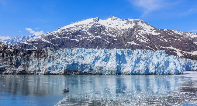
Glacier Bay National Park and Preserve
Fodor's choice
Sorincolac | Dreamstime.com
Tidewater glaciers in Glacier Bay National Park calve icebergs into the sea with loud blasts. Humpback whales breach, spout, and slap their tails against the water. Coastal brown bears feed on sedge, salmon, and berries. Bald eagles soar overhead, and mountains in the Fairweather Range come in and out of view. This magical place rewards those who get out on the water—whether it be in a cruise, a day boat, or a kayak. Glacier Bay is a marvelous laboratory for naturalists of all persuasions. Glaciologists, of course, can have a field day. Animal lovers can hope to see the rare glacial "blue" bears of the area, a variation of the black bear, which is here along with the brown bear; mountain goats in late spring and early summer; and seals on floating icebergs. Humpback whales are also abundant in these waters; the best time to see them is June through early August. Birders can look for the more than 200 species that have already been spotted in the park, and you are assured bald eagle sightings. The bay is a still-forming body of water fed by the runoff of the icefields, glaciers, and mountains that surround it. Today many glaciers in the park, including the namesake glacier of naturalist John Muir, who was one of the region's earliest proponents, continue to retreat: the Muir Glacier's terminus is now scores of miles farther up the bay from the small cabin he built there. However, some of the glaciers are still healthy, such as the Johns Hopkins Glacier and the Marjorie Glacier, which receive enough snow to maintain their size or even grow. Bartlett Cove, an area that's been ice-free for more than 200 years, has a lush spruce-and-hemlock rain forest as well as the 2,500-square-foot Huna Tribal House (Xunaa Shuká Hít), a space for tribal members and for visitors to learn about Tlingit history and culture.
Recommended Fodor's Video
Haines Highway
Fodor's choice
The breathtaking Haines Highway, a National Scenic Byway, starts at Mile 0 in Haines and continues 152 miles to Haines Junction. You don't have to drive the entire length to experience its beauty, as worthwhile stops are all along the route. At about Mile 6 a delightful picnic spot is near the Chilkat River. At Mile 9.5 the view of Cathedral Peaks, part of the Chilkat Range, is magnificent. At Mile 9 begins the Alaska Chilkat Bald Eagle Preserve. In winter the stretch between Mile 19 and Mile 21 harbors the largest concentration of bald eagles in the world. At Mile 33 is a roadside restaurant called, aptly, 33-Mile Roadhouse ( www.33mileroadhouse.com), where you can fill your tank and coffee mug. Grab a burger and, most important, a piece of pie—do not leave without trying the pie. The United States–Canada border lies at Mile 42; stop at Canadian customs and set your clock ahead one hour.
LeConte Glacier
Fodor's choice
Petersburg's biggest draw lies at the foot of the Stikine Ice Cap. Accessible only by air or water, LeConte Glacier is the continent's southernmost tidewater glacier and one of its most active, often calving off so many icebergs that the tidewater bay at its face is carpeted shore to shore with them.
Mendenhall Glacier
Fodor's choice
Glaciers are abundant in Southeast Alaska, but only a very few are as accessible as Mendenhall Glacier. Alaska's most-visited drive-up glacier spans 12 miles and is fed by the massive Juneau Icefield. Like many other Alaska glaciers, it is retreating, losing more than 100 feet a year as huge chunks of ice calve into the small lake separating the glacier from the Mendenhall Visitor Center. The center has interactive and traditional exhibits, a theater and bookstore, and panoramic views. Nature trails lead along Mendenhall Lake, to Nugget Falls, and into the mountains overlooking Mendenhall Glacier; the trails are marked by posts and paint stripes delineating the historic location of the glacier, providing a sharp reminder of Mendenhall's hasty retreat. An elevated viewing platform allows visitors to look for spawning sockeye and coho salmon—and the bears that eat them—at Steep Creek, a half mile south of the visitor center along the Moraine Ecology Trail.
Several companies lead bus tours to the glacier; ask at the visitor information center. You can also get within a mile and a half of the glacier on the city bus, which is $2 one-way. For a different perspective, you can travel by helicopter to the surface of the glacier, or hire a guide to take you to one of the amazing, electric blue ice caves. Note that because the caves are inherently unstable, the Forest Service doesn't recommend self-guided tours.
Misty Fjords National Monument
Fodor's choice
Cliff-faced fjords, tall mountains, waterfalls, and islands with spectacular coastal scenery draw visitors to this wilderness area just east of Ketchikan. Most arrive on day trips via floatplane or aboard a catamaran. Both methods have their advantages: air travel reveals Misty Fjord's enormous scope, while trips by sea afford more intimate vistas. You can also kayak here, but it’s a long paddle from Ketchikan. For a more manageable trip, consider having a boat drop you off within the monument. Traveling on these waters can be an almost mystical experience, with the green forests reflected in the many fjords' waters. You may find yourself in the company of a whale, see a bear along the shore fishing for salmon, or even pull in your own salmon. The 15 cabins the Forest Service manages here can be booked through the federal Recreation.gov website ( www.recreation.gov).
Mt. Roberts Tramway
Fodor's choice
One of Southeast's most popular tourist attractions whisks you from the cruise-ship docks 1,800 feet up the side of Mt. Roberts. After the six-minute ride, you can take in a film on the history and culture of the Tlingits, visit the nature center, go for an alpine walk on hiking trails (including the 5-mile round-trip hike to Mt. Roberts's 3,819-foot summit), purchase Native art and peruse the on-site gallery, or enjoy a meal while savoring mountain views. You can also get an up-close view of an "education" eagle in her mew. A local company leads guided wilderness hikes from the summit, and the bar serves locally brewed beers. Plan to spend one to two hours at the top. For a workout, hike up the mountain from town or hike to Father Brown's Cross from the top; each takes about an hour.
Pack Creek
Fodor's choice
More than 90% of Admiralty Island is preserved within the Kootznoowoo Wilderness. Its chief attraction is Pack Creek, where you can watch brown bears feeding on salmon. One of Alaska's premier bear-viewing sites, Pack Creek is comanaged by the U.S. Forest Service and the Alaska Department of Fish and Game. Permits are required during the main viewing season, from June 1 through September 10. If you're headed to Pack Creek without a guide or an experienced visitor, be sure to cover the basics of bear safety before your trip. Permits for Pack Creek can be processed through www.recreation.gov.
Salmon Glacier
Fodor's choice
A spectacular unpaved road from Hyder into Canada winds 17 miles to remote Salmon Glacier, one of the few glaciers accessible by road in Southeast Alaska and the fifth biggest glacier in North America. In summer, take Granduc Mine Road (also referred to as Salmon Glacier Road), which climbs several thousand feet to a viewing area. Be prepared for potholes, steep drop-offs, and incredible vistas along the way. The District of Stewart BC website provides a helpful downloadable Auto Tour Brochure of the route.
Sealaska Heritage's Walter Soboleff Building
Fodor's choice
This center devoted to Alaska Native art, culture, and language is operated by Sealaska Heritage Institute and named for a local Tlingit elder who died at age 102 in 2011. It includes an exhibits gallery, a traditional clan house, research areas, and a shop selling work by Northwest Coast artists. The building's three major public art pieces—exterior red metal panels, a carved cedar house front in the lobby, and a modern glass screen in the clan house—were created by three of the top Northwest Coast artists in the world (Robert Davidson, David A. Boxley, and Preston Singletary), and represent the three Indigenous tribes of Southeast Alaska—Haida, Tsimshian, and Tlingit, respectively. The art pieces also highlight the center's dual role in honoring tradition while remaining forward-facing and contemporary. Among the goals of this facility are promoting Juneau's role as a hub of Northwest Coast art and fostering cross-cultural understanding. Across the street from the building, an arts campus devoted to both goals is set to open in early 2022.
Sitka National Historical Park
Fodor's choice
The main building at this 113-acre park houses a small museum with fascinating historical exhibits and photos of Tlingit Native culture. Highlights include a brass peace hat given to the Sitka Kiks.ádi by Russian traders in the early 1800s and Chilkat robes. Head to the theater to watch a 12-minute video about Russian–Tlingit conflict in the 19th century. Ask a ranger to point you toward the Centennial Totem Pole, installed in 2011 to honor the park's 100th anniversary. Also here is where Native artisans demonstrate silversmithing, weaving, wood carving, and basketry. Make an effort to strike up a conversation with the artists; they're on-site to showcase and discuss their work and Tlingit cultural traditions. At the far end of the building are seven totems (some more than a century old) that have been brought indoors to protect them from decay. Behind the center a wide, 2-mile path winds through the forest and along the shore of Sitka Sound. Scattered along the way are some of the most skillfully carved Native totem poles in Alaska. Keep going on the trail to see spawning salmon from the footbridge over Indian River. In summer, Park Service rangers lead themed walks that focus on the Russian–Tlingit conflict, the area's natural history, and the park's totem poles.
About a quarter of the Ketchikan bus tours include this park that contains many totem poles and has a hand-hewn Native clan house. Totem Bight sits on a scenic spit of land facing the waters of Tongass Narrows. Master Native carvers crafted the first replica poles here as part of a U.S. Forest Service program that began in the late 1930s. The tools the carvers used were handmade in the Native style, and modern paints were employed to re-create colors originally made using natural substances from clamshells to lichen. The clan house, open daily in summer, was built to resemble a type that might have held several related families. Note the raven painting on the front: each eye contains a small face. Try to save time for a stop at nearby Potlatch Totem Park as well.
The island is famous for its lush old-growth rain forest and abundant wildlife, including one of the largest concentrations of brown bears anywhere on the planet. The Tlingit name for the island is Kootznoowoo (Xootsnoowú), meaning "Fortress of the Bears." Ninety miles long, with 678 miles of coastline, Admiralty—the second-largest island in Southeast Alaska—is home to an estimated 1,600 bears, almost one per square mile.
Admiralty Island National Monument
The Forest Service's Admiralty Island National Monument has a canoe route that crosses the island via a chain of lakes and trails, and some of the region's best sea kayaking and sportfishing happens here. The area is said to have the world's highest density of nesting bald eagles, and there are large concentrations of humpback whales. Fourteen public-use cabins are available for overnight stays.
Alaska Chilkat Bald Eagle Preserve
In winter, the section of the preserve between Mile 19 and Mile 21 of the Haines Highway harbors the largest concentration of bald eagles in the world. In November and December, more eagles gather outside Haines than live in the continental United States. Thousands come to feast on the late run of salmon in the clear, ice-free waters of the Chilkat River, which is heated by underground warm springs.
Alaska Indian Arts
Dedicated to the preservation and continuation of Alaska Native art, this nonprofit organization occupies what was Ft. Seward's hospital. You can watch artisans doing everything from carving totem poles to creating delicate silver jewelry.
Alaska Rainforest Sanctuary
The word "rainforest" may not immediately spring to mind when you picture Southeast Alaska, but as you walk amidst the giant cedars, hemlocks, and spruces at the Alaska Rainforest Sanctuary, the term will come into vivid focus, encompassing not just the trees but the interconnected web of plants and animals that live with them. The only way to experience the sanctuary is via a short, easy hike led by a naturalist guide; while on the trail, you'll keep an eye out for wildflowers, berries, bears, eagles, deer, and Herring Creek salmon. Located 8 miles outside Ketchikan, the tour is offered in all weather; sturdy shoes and a waterproof jacket are highly recommended.
Alaska Raptor Center
Above Indian Creek, a 20-minute walk from downtown, Alaska's only full-service avian hospital rehabilitates from 100 to 200 birds each year. Well-versed guides provide an introduction to the center (there's also a short video), and guests can visit with one of these majestic birds. The primary attraction is an enclosed 20,000-square-foot flight-training center, built to replicate the rain forest, where injured eagles relearn survival skills, including flying and catching salmon. Visitors watch through one-way glass windows. A large deck out back faces an open-air enclosure for eagles and other raptors whose injuries prevent them from returning to the wild. Additional mews with hawks, owls, and other birds lie along a rain forest path. The gift shop sells all sorts of eagle paraphernalia, the proceeds from which fund the center's programs.
Completed in 1931, this unassuming building houses the governor's office and hosts state legislature meetings in winter, placing it at the epicenter of Alaska's animated political discourse. Historical photos line the upstairs walls. You can pick up a self-guided tour brochure as you enter.
American Bald Eagle Foundation
The main focuses at this natural history museum are bald eagles and associated fauna of the Chilkat Preserve. Lectures, displays, videos, and a taxidermy-heavy diorama help tell their stories, and there's a raptor center that has live presentations and an aviary displaying live eagles.
Arctic Brotherhood Hall
The local members of the Arctic Brotherhood, a fraternal organization of Alaska and Yukon pioneers, built their hall's (now renovated) false front out of 8,833 pieces of driftwood and flotsam from local beaches. The result: one of the most unusual buildings in all of Alaska. The AB Hall now houses the Skagway Convention & Visitors Bureau, along with public restrooms.
Bartlett Lake Trail
The longest of the Bartlett Cove trails is an offshoot of the Bartlett River Trail. Look for the trailhead about a mile down the river trail on your right. After climbing a moraine, you weave through the woods for approximately 4 miles before reaching the lake. The serenity and the views make the total 12-mile journey—a seven- to eight-hour, out-and-back endeavor—worth the effort. Moderate–difficult.
Bartlett River Trail
This 5-mile, round-trip route borders an intertidal lagoon, runs alongside an old glacial moraine, zigzags through the woods, and spits you out in a designated wilderness area at the Bartlett River estuary. From the trailhead, located a short walk from Glacier Bay Lodge, it's about 2 miles to the river, and although this portion can be muddy and slippery, the park service does maintain it. The stretch that continues along the riverbank for a couple more miles isn't maintained, and segments of it can be difficult to navigate, depending on the tide or recent rainfall. Bear sightings are common here, especially when the salmon are running. Moderate–difficult.
Blind Slough Recreation Area
This recreation area includes a number of sites scattered along the Mitkof Highway from 15 to 20 miles south of Petersburg. Blind River Rapids Trail is a wheelchair-accessible 1-mile boardwalk that leads to a three-sided shelter overlooking the river—one of Southeast's most popular fishing spots—before looping back through the muskeg. Not far away is a bird-viewing area where several dozen trumpeter swans spend the winter. In summer you're likely to see many ducks and other waterfowl. At Mile 18 the state-run hatchery releases thousands of king and coho salmon each year. The kings return in June and July, the coho in August and September. Nearby is a popular picnic area. Four miles south of the hatchery is a Forest Service campground.
Castle Hill
On this hill, Alaska was formally handed over to the United States on October 18, 1867, and the first 49-star U.S. flag was flown on January 3, 1959, signifying Alaska's statehood. To reach the hill, take the first right off Harbor Drive just before O'Connell Bridge; then enter the paved path switchbacks to the top, where you can read the interpretive signs on the area's Tlingit and Russian history and take in the views of Crescent Harbor and downtown Sitka. On a clear day, look for the volcanic flanks of Mt. Edgecumbe on the horizon.
Chief Shakes Island and Tribal House
A footbridge from the bottom of Shakes Street provides access to this small island in the center of Wrangell's protected harbor. The Tribal House, constructed in 1940 as a replica of the original 19th-century structure, was completely restored by local carvers in 2012 and 2013, as were the surrounding totem poles. The interior of the building can be viewed for a fee; arrangements should be made through the Wrangell Cooperative Association (www.wca-t.com).
Chief Shakes's Grave Site
Buried here is Shakes V, who led the local Tlingit during the first half of the 19th century. A white picket fence surrounds the grave, and two killer-whale totem poles mark his resting spot, which overlooks the harbor.
Chilkat State Park
This park on Chilkat Inlet has beautiful and accessible viewing of both the Davidson and Rainbow glaciers. The Seduction Point Trail, about 7 miles one way, takes hikers to the very tip of the peninsula upon which Haines sits.
Clausen Memorial Museum
The exhibits here explore commercial fishing and the cannery industry, the era of fish traps, the social life of Petersburg, and Tlingit culture. Don't miss the 126½-pound king salmon—the largest ever caught commercially—as well as the Tlingit dugout canoe; the Cape Decision lighthouse station lens; and Earth, Sea and Sky, a 3-D wall mural outside.
Subscribe to Newsletter
Sign up for Travel Tips & News
I want emails from Fodor's Travel with travel information and promotions. I can unsubscribe any time using the unsubscribe link at the end of all emails.
Thank you for your interest!
Look out for our newsletters with travel tips and special offers.
Sign up for Travel Tips & News
By signing up for the newsletter, I agree to the Privacy Policy. You must check the box to subscribe
Thank you for your interest!
Look out for our newsletters with travel tips and special offers.