West Coast National Parks
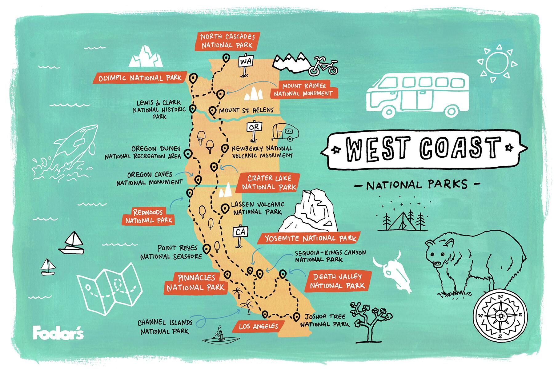
West Coast National Parks
From the otherworldly desertscapes, soaring redwoods, and eye-popping canyons of California to the volcanic peaks, lush rainforests, and pristine beaches of the Pacific Northwest, the West Coast contains some of the country's most celebrated national parks.
At A Glance
TRAVELED3,900SUGGESTED
DURATION19 nightsstates
VISITEDCalifornia, Oregon, Washington
You probably already know about the “bucket list” destinations like Yosemite, Crater Lake, and Mt. Rainier, and on this tour you’ll enjoy the opportunity to see what makes these iconic parks so special. ...Read More
But on this journey north through inland California, Oregon, and Washington and then back down along these three states’ rugged coastlines, you’ll also discover some of the park system’s hidden treasures—underrated yet dazzling landscapes like Lassen Volcanic, North Cascades, Oregon Caves, Pinnacles, and Channel Islands.
This itinerary covers a lot of ground, and you’ll need about three weeks to spend even a day at every park highlighted. If you’re able to set aside four-to-six weeks for this adventure, you’ll be able explore and appreciate the landscape more thoroughly. Keep in mind, access to parts of some parks is limited in winter, especially those in higher elevations, such as Yosemite’s East Entrance, Crater Lake’s North Entrance, and North Cascades main park highway. The best strategy for timing this trip is to set out in April or May, when the temperatures in the desert are mild and then work your way north to time your arrival in the mountainous parks of the Northwest with warmer weather. Then make your way south down the coast, which is lovely all summer long. Read Less
At A Glance
TRAVELED3,900SUGGESTED
DURATION19 nightsstates
VISITEDCalifornia, Oregon, Washington
Explore All Road Trips


West Coast National Parks
19 nights | 3900 miles
Los Angeles to Joshua Tree National Park
Joshua Tree National Park to Death Valley
Death Valley to Kings Canyon National Parks

Kings Canyon National Parks to Yosemite National Park

Yosemite National Park to Lassen Volcanic National Park
Lassen Volcanic National Park to Crater Lake National Park
Crater Lake National Park to Newberry National Volcanic Monument

Newberry National Volcanic Monument to Mt. St. Helens

Mt. St. Helens to Mt. Rainier
Mt. Rainier to North Cascades National Park

North Cascades National Park to Olympic National Park
Olympic National Park to Lewis and Clark National Historical Park
Lewis and Clark National Historical Park to Oregon Dunes National Recreation Area
Oregon Dunes National Recreation Area to Oregon Caves National Monument
Oregon Caves National Monument to Redwood National Park
Redwood National Park to Point Reyes National Seashore

Point Reyes National Seashore to Pinnacles National Park

Pinnacles National Park to Channel Islands National Park
Channel Islands National Park to Los Angeles
The Itinerary
STOP 1 Los Angeles to Joshua Tree National Park
STOP 2 Joshua Tree National Park to Death Valley
STOP 3 Death Valley to Kings Canyon National Parks
STOP 4 Kings Canyon National Parks to Yosemite National Park
STOP 5 Yosemite National Park to Lassen Volcanic National Park
STOP 6 Lassen Volcanic National Park to Crater Lake National Park
STOP 7 Crater Lake National Park to Newberry National Volcanic Monument
STOP 8 Newberry National Volcanic Monument to Mt. St. Helens
STOP 9 Mt. St. Helens to Mt. Rainier
STOP 10 Mt. Rainier to North Cascades National Park
STOP 11 North Cascades National Park to Olympic National Park
STOP 12 Olympic National Park to Lewis and Clark National Historical Park
STOP 13 Lewis and Clark National Historical Park to Oregon Dunes National Recreation Area
STOP 14 Oregon Dunes National Recreation Area to Oregon Caves National Monument
STOP 15 Oregon Caves National Monument to Redwood National Park
STOP 16 Redwood National Park to Point Reyes National Seashore
STOP 17 Point Reyes National Seashore to Pinnacles National Park
STOP 18 Pinnacles National Park to Channel Islands National Park
STOP 19 Channel Islands National Park to Los AngelesLos Angeles to Joshua Tree National Park, California
Town: Palm Springs. The Coachella Valley’s classic desert resort community—long famous with Hollywood folks and as one of the country’s top LGBTQ destinations—the small desert city of Palm Springs (population 48,000) is a popular gateway to Joshua Tree National Park, worth at least a short stop to stroll among downtown’s distinctive design shops, galleries, and eateries and maybe even to ride the thrilling Palm Springs Aerial Tramway, which carries passengers through Chino Canyon to an elevation of 8,516 feet, near the summit of Mt. San Jacinto. Here you can hop out for a view east that takes in Joshua Tree, and even set out on an alpine hike. Alternately, you can make Palm Springs your base for visiting Joshua Tree, keeping in mind that it’s a little under an hour’s drive to entrances at on either side of the park.
Eat & Drink: Downtown Palm Springs pulses with inviting restaurants, many with sprawling patios cooled off on hot days by misting machines. One favorite is Cheeky’s for daily brunch and lunch, where you can order chilaquiles, buttermilk corn pancakes, and a “flight” of five types of bacon. Or for a memorable dinner, sample the inspired global cuisine at 4 Saints, which occupies the seventh floor of the trendy Kimpton Rowan Hotel.
Shops: The Uptown Design District along North Palm Canyon Drive is a stretch of cool shops—including colorful Trina Turk for swimwear and fashion and ’50s-chic Shag for art and housewares—specializing in the mid-century modern aesthetic for which Palm Springs is internationally famous.
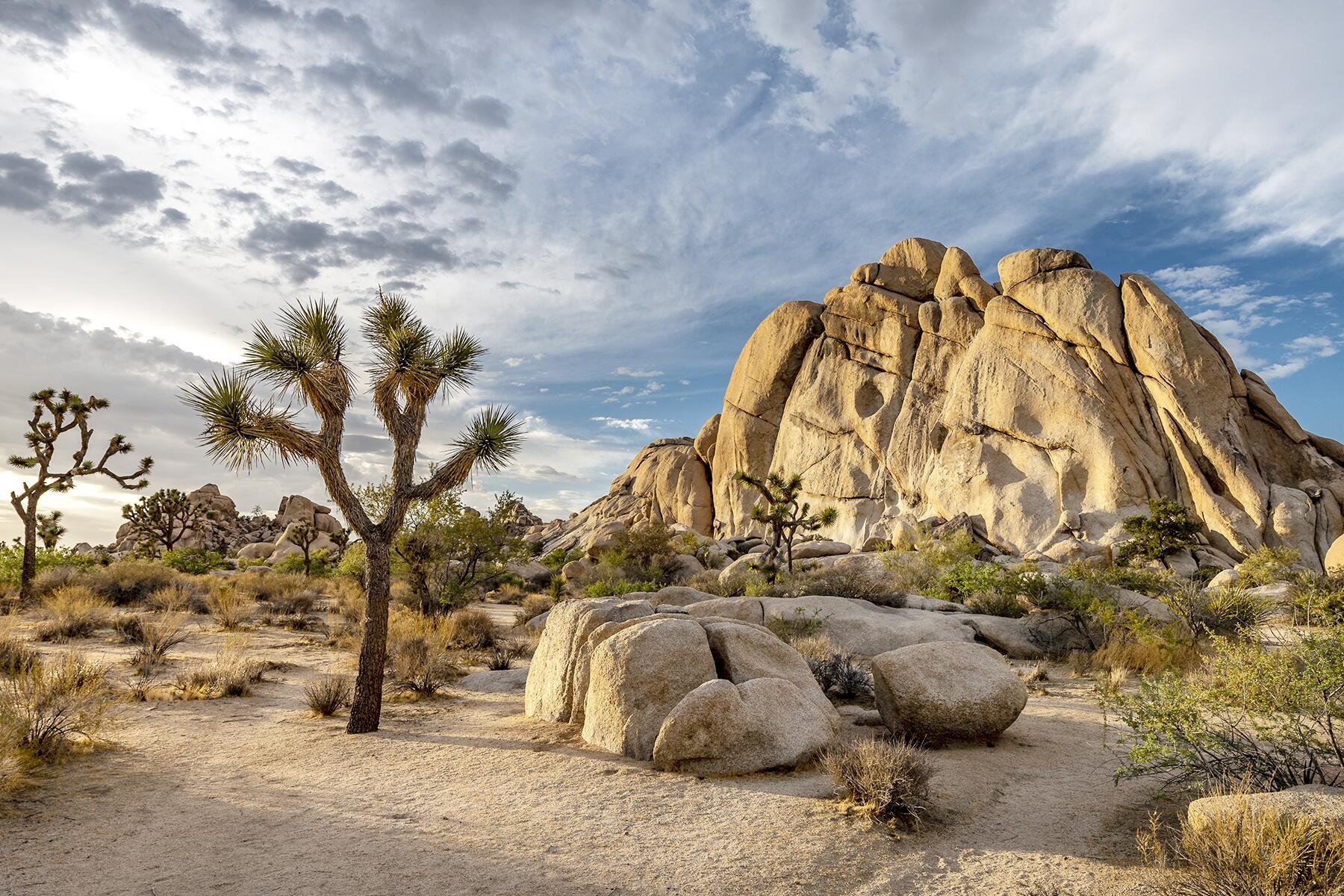
Do: This 800,000-acre expanse of the Mojave and Sonoran deserts contains hundreds of the distinctive Joshua trees for which the park is named. It can be appreciated in a day, but allowing two will give you the chance to explore some of the scenery a bit farther afield, such as making the somewhat challenging 2-mile hike to Lost Horse Mine. Joshua Tree’s Park Boulevard extends for more than 50 miles through the park, and especially if you’re staying in Palm Springs one or both nights, it’s worth either starting or ending on this drive via the park’s southeastern entrance off I-10. Must-sees that are easy to access from the main park road include the boulder-strewn paths around Skull Rock and the Jumbo Rocks Campground, and Hidden Valley and Cap Rock, which you can tour via easy loop trails dotted in places with Joshua trees. Be sure to make the 6-mile side drive to Keys View overlook, from which you can see the San Andreas Fault and the Salton Sea, and on clear days, the craggy mountain peaks of northern Mexico.
Eat & Drink: The region’s greatest wealth of dining and nightlife options is in Palm Springs, but there are some notable eateries near to the park’s Western Entrance. Near Yucca Valley, Pappy & Harriett’s Pioneertown Palace is located on an old Hollywood set that figured in dozens of movies in the ’40s and ’50s and is now an offbeat venue for watching live bands while eating stick-to-your-ribs burgers, steaks, and Tex-Mex fare. After dinner, stop to people-watch at the retro-cool Virginian cocktail bar.
Stay: If you stay in Palm Springs, which has dozens of chain properties in every price range, consider one of the lodgings near the north end of town—which puts you a little closer to the park—such as stylish Arrive Palm Springs, with its chic vibe and an on-site artisanal ice cream shop. Closer to the park, the funky, moderately-priced 29 Palms Inn comprises about two-dozen rooms and cottages set amid 70 acres of palm trees, desert gardens, an art gallery, and colorful restaurant.
Breakfast: Fuel up for a day of park touring or before heading north toward Death Valley at JT Country Kitchen, a down-home diner where biscuits and gravy, breakfast burritos, French toast, and other breakfast treats are served all day.
Joshua Tree National Park to Death Valley, California
Town: Badwater Basin. There’s not a lot to see or do—beyond soaking up the sweeping Mojave Desert vistas—along this remote route, but once you reach the town of Shoshone, about three hours into your drive, you have the option of accessing the park via the southeastern route along Hwy. 178 through stark yet desolately beautiful Badwater Basin. At 282 feet below sea level, this is the lowest point in the Western Hemisphere. As you continue north toward Furnace Creek, check out the dramatic rock formations at Natural Bridge and Devil’s Golf Course. Traveling this route adds about an hour to the drive without stops.
Eat & Drink: In tiny Shoshone, the Crowbar Cafe & Saloon is filled with old mining paraphernalia and photos of the region, and is a colorful stop for enjoying flame-grilled rainbow trout, fish tacos, and other hearty Western dishes.
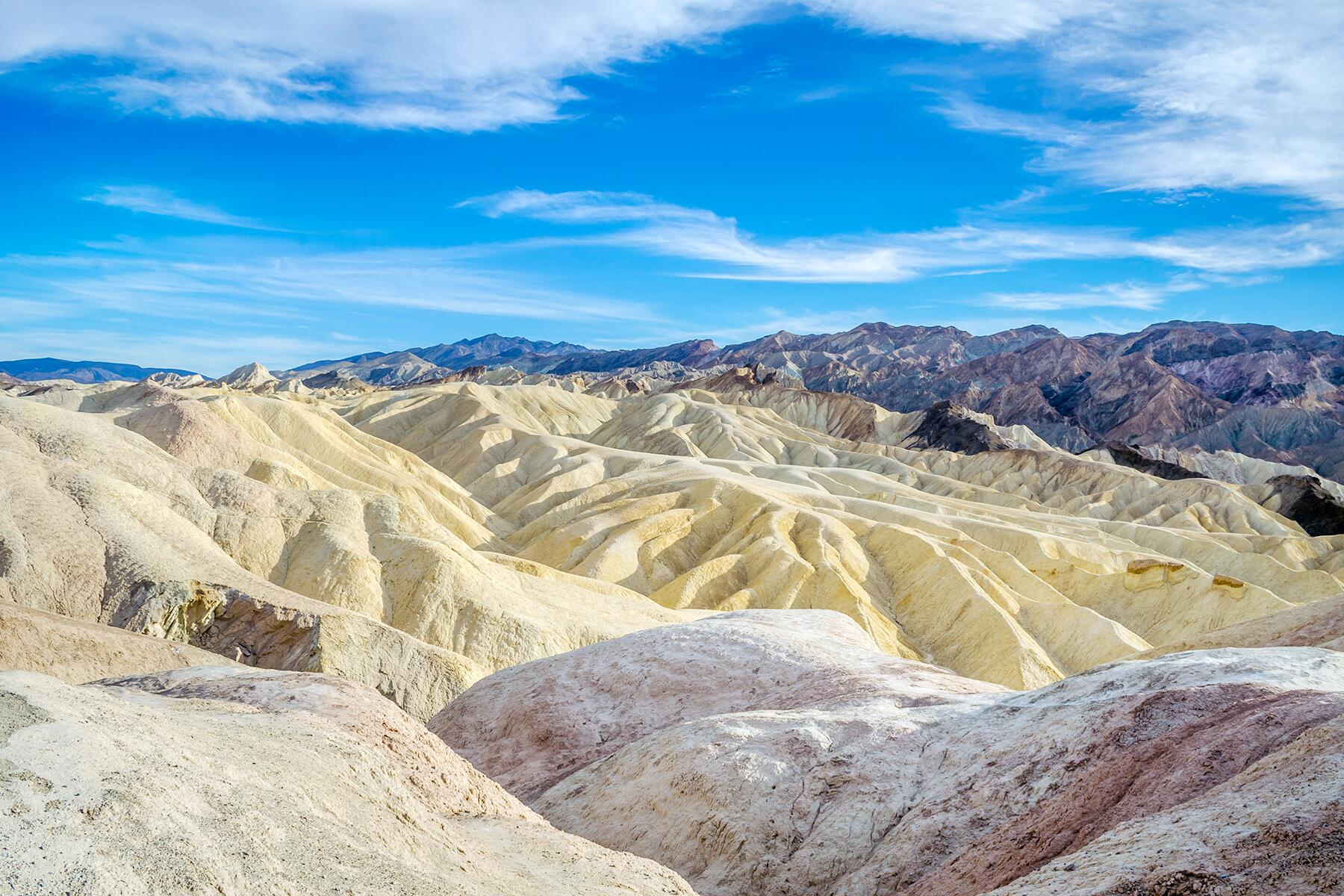
Do: At 3.4 million square miles, Death Valley is the largest U.S. national park outside Alaska, and although its name hints at some of the hottest temperatures and most unforgiving terrain in the world, it’s also a land of considerable diversity, with multicolored canyons, 11,000-foot peaks, undulating sand dunes, and fragrant wildflower meadows. Start the day with a drive along 9-mile Artist’s Drive, admiring the brilliantly-hued landscape, then continuing on a short distance north to the rewarding 2-mile Golden Canyon Interpretive Trail. Later in the day, check out Zabriskie Point, which takes in the park’s dramatic, multihued hills, and Dante’s View, a mile-high lookout in the Black Mountains from which you can see many of Death Valley’s most remarkable features. If you’re able to spend an extra night or two in the park, spend time at some of the park’s fascinating historic sites, such as Harmony Borax Works, and definitely make the worthwhile detour 60 miles from Furnace Creek to see Scotty’s Castle Museum, an ornately furnished 1920s Moorish-style mansion at the northern end of the park.
Eat & Drink: With its astounding valley views and a dramatic interior with fireplaces and beamed ceilings, the Inn at Furnace Creek Dining Room is the park’s signature restaurant, serving innovatively prepared seasonal cuisine as well as refreshing prickly-pear margaritas.
Stay: Given how far Death Valley is from other cities, it’s advisable to stay inside the park, which has a handful of options. It tends to book up early during busy periods, but the beautifully restored 1927 Inn at Furnace Creek is the most treasured of these. Offering simpler motel-style accommodations, Stovepipe Wells Village is a more economical option with a peaceful location near striking Mesquite Flat Sand Dunes.
Breakfast: Located in Stovepipe Wells Village, Panamint Springs Resort Restaurant turns out a popular Continental breakfast buffet and has an attractive patio with grand vistas of Panamint Valley.
Death Valley to Kings Canyon National Parks, California
Town: Bakersfield. This city of about 385,000 in California’s Central Valley is a good place to break up your journey. Highlights include an emerging Downtown Arts District, and the California Living Museum, which is northeast of the city and encompasses an exceptional zoo, botanical garden, and natural history museum.
Eat & Drink: An Italian grocery and restaurant that’s been a fixture in Bakersfield since 1910, Luigi’s remains a favorite place for big portions of hot pastrami sandwiches, pasta Bolognese, and house-made cheesecake.
Do: These spectacular alpine parks each offer a different kind of landscape, with Sequoia all about the towering, ancient conifers—the world’s largest trees—for which it’s named, and Kings Canyon renowned for its sweeping alpine peaks and valleys. If you can, set aside a day to explore each park. You can gain a real sense of Sequoia’s awe-inspiring landscape by arriving on Hwy. 198 through the Ash Mountain Entrance, and then climbing some 3,500 feet along Generals Highway where you can visit the engaging Giant Forest Museum, and strolling amid the sequoia trees in Round Meadow and along the Big Trees Trail. Other highlights include the famed 274.9-foot General Sherman Tree, which ranks among the world’s oldest and highest trees, and climbing the stone steps to the scenic overlook from Moro Rock. To explore Kings Canyon, spend a day in and around Grant Grove Village with a short trek to Panoramic Point, a look at Grizzly Falls, and a stroll through magnificent Zumwalt Meadow, with its grand views of the Kings River and the Grand Sentinel and North Dome rock formations.
Eat & Drink: In Sequoia, The Peaks restaurant inside Wuksachi Lodge is famous for its giant fireplace and locavore-minded seasonal cuisine—the most storied restaurant in either park, it tends to book up well in advance, so reservations are essential. The top dining option in Kings Canyon, Grant Grove Restaurant was handsomely redesigned in 2019 and has a large dining room overlooking expanses of sequoia trees and a lovely deck overlooking the wildflowers of Bradley meadow; the kitchen turns out creative American cuisine with a focus on sustainable ingredients.
Stay: The lodging options in these parks are amazing for their jaw-dropping settings, especially the grand, cedar-and-stone Wuksachi Lodge in Sequoia, a contemporary structure with stylish rooms set in neighboring buildings. The timber-frame John Muir Lodge in Kings Canyon has relatively simple rooms but offers a quiet setting a bit away from the crowds of nearby Grant Grove village. If unable to book a park lodging, you’ll find a wide range of options in the small (population 135,000) city of Visalia, about 45 minutes to an hour west of the parks.
Breakfast: Convenient options in the park include the aforementioned Grant Grove Restaurant in Kings Canyon, and the casual Lodgepole Market, Deli, and Cafe in Sequoia. Both are conveniently located and will have you out exploring the landscape in no time.
Kings Canyon to Yosemite National Park, California
Town: Fresno. This city of 530,000 in the heart of California’s San Joaquin Valley offers some standout attractions that make it worth a stop during your drive to Yosemite. Highlights include the fanciful grottoes and tunnels of Forestiere Underground Gardens and the considerable pre-Columbian Mesoamerican and Andean holdings of the impressive Fresno Art Museum. The lively Tower District abounds with inviting restaurants and cafés.
Eat & Drink: Set along Hwy. 180 midway between Kings Canyon and Fresno, the stylish School House Restaurant & Tavern occupies a 1920s red-brick schoolhouse and turns out locally-sourced lunch and dinner fare, such as steak Cobb salads, spiced-lamb-and-beef burgers, and a house favorite, pear bread pudding with vanilla ice cream, candied walnuts, and fresh basil.
Photo Op: Inside the park, Wawona Road (Hwy. 41) continues north from the South Entrance up into Yosemite Valley. As you approach the valley, you’ll pass through a tunnel, and the view as you emerge is mesmerizing.
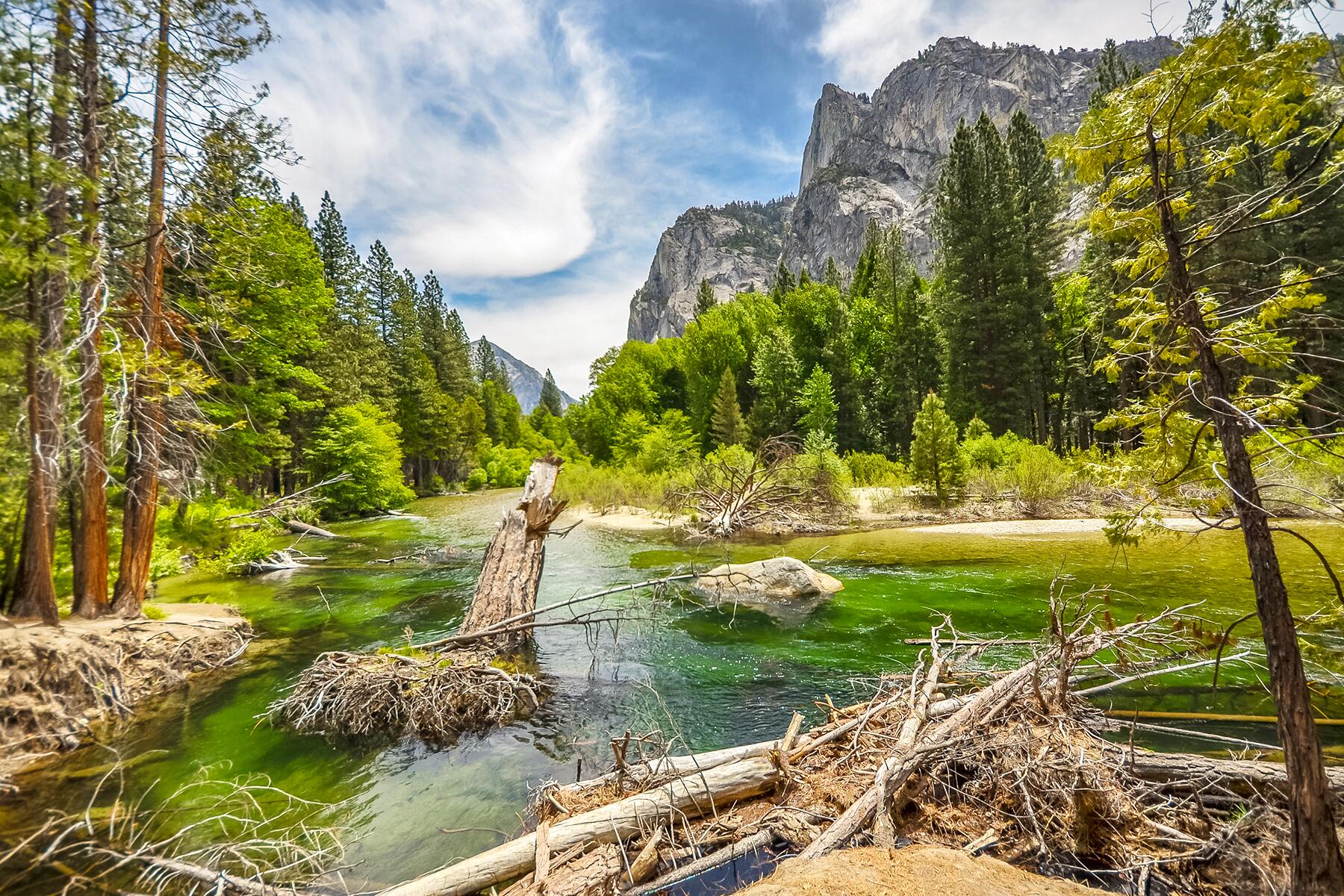
Do: One of the most celebrated landscapes in America, Yosemite ranges across nearly 1,200 square miles and could really be described as several parks in one—consider spending a few days here if you can. During a shorter stay, you can view the stands of imposing sequoia trees in Mariposa Grove in Wawona, which is the easiest area to access if coming from Fresno. And you can focus the rest of your time on the iconic sites of Yosemite Valley—admiring legendary El Capitan (the largest exposed-granite monolith on the planet), checking out the roaring triple cascades of 2,425-foot-tall Yosemite Falls, driving (or taking a free park shuttle) to the overlook atop Glacier Point for an astounding view of the valley, and embarking on one or two shorter or even half-day hikes, such as the 3-mile Mist Trail to Vernal Fall or the 8.5-mile Panorama Trail from Glacier Point, which provides you terrific views of Half Dome. With more time, you could potentially hike Half Dome (allow about 12 hours for this arduous trek via the John Muir Trail, and note that hiking permits are required and are awarded in advance by lottery). In summer, as you exit the park through the Eastern Entrance, you can drive the breathtaking 59-mile Tioga Road to Tuolumne Meadows and on to Lee Vining.
Eat & Drink: You’ll find fewer more eye-popping dinner settings than a table inside the vaunted Ahwahnee Dining Room, where rarefied modern American cuisine is served beneath ornate chandeliers and a 34-foot ceiling. The brunch here is legendary. Panoramic views of Yosemite Falls frame your meal at the Yosemite Valley Lodge’s Mountain Room, which serves sustainably-sourced steaks and seafood and is another of the park’s most memorable dining venues.
Stay: Designed by Gilbert Stanley Underwood in the late 1920s, the grand stone-and-timber Ahwahnee is one of the country’s singular national parks lodges, with its Native American design motifs, art deco accents, and even a heated outdoor pool. It’s expensive, and always booked well in advance, but it’s absolutely worth a splurge. Less pricey but still exuding character, the 1879 Wawona Hotel is surrounded by the sequoias and alpine scenery of Yosemite southern’s reaches and is decked with wraparound verandas. Outside the park, the town of Oakhurst has plenty of options, and you’ll find some nifty lodgings in Groveland, Fish Camp, Mariposa, and other towns to the west as well.
Breakfast: Especially convenient if you’re headed toward Tuolumne Meadows, the White Wolf Lodge is a pleasingly rustic spot 30 miles northwest of Yosemite Valley, offering all-you-can-eat home-style breakfasts. It’s a great deal for pre-hiking sustenance.
Yosemite National Park to Lassen Volcanic National Park, California
Town: Mono Lake and Lee Vining. Along U.S. 395 not far from Yosemite’s eastern entrance, Lee Vining is a cute, friendly village that’s home to remote, enormous Mono Lake, with its eerie calcium-carbonate tufas (hoodoo-like rock formations), which you can get a better look at on free nature walks offered in summer through the Mono Basin Scenic Area Visitor Center. If you have an extra couple of hours, consider making the side trip just north of Mono Lake along Hwy. 270 to Bodie Ghost Town, an abandoned late Victorian mining village with a fascinating museum and tours available of the old stamp mill.
Eat & Drink. Many who pass through Reno give it no more than a quick look, perhaps taking in its glitzy skyline of neon-streaked casino towers, but “the biggest little city in the world” has a revitalized downtown with attractive promenades along the Truckee River and a number of excellent restaurants. Old World Coffee Lab is a hip stop for well-crafted espresso drinks and fresh-baked bagels. Beside the river, Sierra Street Kitchen and Cocktails offers tasty internationally-inspired tapas, creative sips, and live music some evenings.
Detour: Upon reaching Lee Vining, a right turn south onto U.S. 395 leads 30 miles south to the beautiful mountain town of Mammoth Lakes, an upscale ski town that’s become increasingly popular for hiking and outdoor recreation in summer. Another 15 miles along windy and scenic Hwy. 203 will get you to Devils Postpile National Monument. Here you can view the walls of volcanic basalt columns that give this park its name, and also admire Rainbow Falls, where a tributary of the San Joaquin River cascades over a lava-rock cliff. Driving all the way to Devils Postpile will add about three hours round-trip to your journey, not including stops, so you might consider spending the night in Mammoth Lakes if you make this side trip.
Do: Although named for the now dormant plug volcano at its heart, which erupted dramatically in 1915, this 165-square-mile national park is more diverse than its name suggests, offering miles of trails through dense alpine forests and wildflower meadows. The drive north along Lassen Park Highway (Hwy. 89 as it passes through the park) is a gem, passing by the Devastated Area, which still shows evidence of the 1915 eruption, and leading to the gorgeous scenery around Manzanita Lake, where you can visit the excellent Loomis Museum and enjoy a stroll along the 1-mile Lily Pond Nature Trail. Other draws include the 3-mile round-trip Bumpass Hell Trail, which reveals some of the park’s most exciting geothermal features, including steam vents, mud pots, and boiling lakes, and assuming you’re fit for a 2,000-foot climb, undertaking the 2.5-mile hike to the 10,457-foot summit of Lassen Peak.
Eat & Drink: Dining options in the park are limited, but the Restaurant at Highlands Ranch Resort, just outside the park’s southern entrance, doles out sophisticated fare from a high-ceilinged dining room with huge windows and a spacious deck overlooking a pastoral meadow. You’ll find a smattering of cafés and bars a bit east in the small town of Chester and larger community of Susanville, which is home to Lassen Ale Works, a lively spot for gourmet pizza and distinctive craft beers.
Stay: About 10 miles from the park’s southern entrance, the upscale Highlands Ranch Resort is a standout for its plush bungalows, many with outdoor hot tubs. Inside the park, near the northern entrance, Manzanita Lake Camping Cabins is a great, reasonably priced option comprising 20 rustic but handsome modern cabins that can sleep from two to eight people. The famed Drakesbad Guest Ranch is also an absolute stunner, but it’s in a remote part of the park, a 90-minute drive from the Kohm Yah-mah-nee Visitor Center, and only recommended if you’re staying in the area for at least a couple of nights.
Breakfast: In the small town of Chester, Cravings Cafe is a bright and cheerful place set in a historic building and serving up flavorful breakfast burritos and Belgian waffles.
Lassen Volcanic National Park to Crater Lake National Park, Oregon
Town: Klamath Falls. Just over the California border, this rural gateway to several nearby wildlife refuges as well as the southern entrance to Crater Lake has a historic downtown with some small but worthy attractions, including the Klamath County Museum, which provides a thorough overview of the region’s natural and human history. Bird-lovers should make a point of visiting the Lower Klamath National Wildlife Refuge, which receives visits from more than 400 types of birds throughout the migratory seasons, including about 30 types of raptors.
Eat & Drink: Specializing in single-origin coffees, grilled panini sandwiches (the asparagus-prosciutto version is a favorite), fresh-made soups, and grab-and-go prepared foods, cozy art-filled Gathering Grounds Cafe is in the heart of downtown Klamath Falls.
Nature: About midway between Lassen and Crater Lake, at the 47,000-acre Lava Beds National Monument, you can explore miles of lava tubes created when Mammoth Crater erupted some 32,000 years ago. Hiking trails also traverse the above-ground volcanic landscape, with its cinder cones and lava flows.
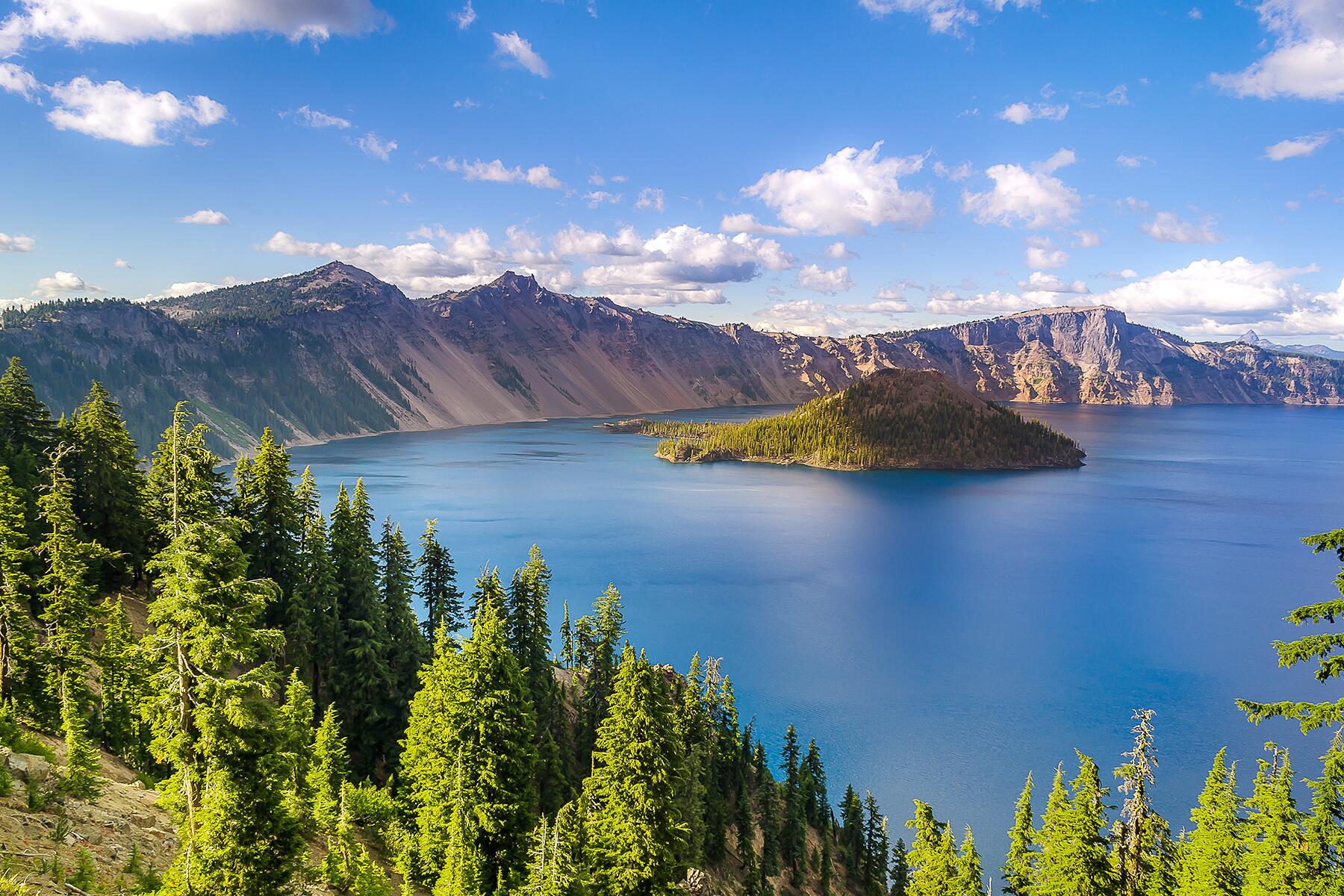
Do: The 33-mile Rim Drive loop around America’s clearest and deepest lake offers dazzling views at numerous vista points, especially Sun Notch, Discovery Point, and Cloudcap Overlook, which also affords views of the park’s highest point, Mt. Scott, an 8,934-foot volcano. If you have a full day to visit the park, take a boat cruise to Wizard Island and hike to the top of this cinder cone, which rises 763 feet above the lake’s surface, for a distinctive view of the rim and the lake. This is also a good place to hike part of the Pacific Crest Trail, which extends 33 miles through the park, including an easily accessed 6-mile portion that runs from just east of the park’s North Entrance, eventually winding down around the lake’s western rim.
Eat & Drink: Built in 1915 on a bluff on the South Rim, the Crater Lake Lodge is a magnificent setting to feast on steaks and wild game—try to get a seat near the massive fireplace in the Dining Room. Or simply enjoy drinks and light appetizers in the lobby or out on the terrace, overlooking the lake. Bear in mind that although Crater Lake is a bit remote and lacks nearby dining, the small southern Oregon cities of Ashland and—increasingly—Medford abound with seriously good eats as well as excellent breweries, wineries, and distilleries. They’re 1.5-to-2 hours away, but some park visitors stay in these areas because they’re conveniently off I–5 and are rife with things to see and do as well as hotels and inns.
Stay: A stately timber-and-stone building with soaring green gables, the historic Crater Lake Lodge is the classic accommodation in the park, an enchanting experience even despite its smallish, bare-bones (no a/c, basic furnishings) rooms. The sterling lake views from many rooms, and the common spaces replete with gleaming wood floors, vintage photos, and sturdy fireplaces invite guests to linger. Often booked months in advance, the lodge isn’t the only option in the park: the modest Cabins at Mazama Village offer reasonably-priced, clean rooms and are just a short drive from the lake’s rim.
Breakfast: Just 15 miles outside the park, Beckie’s Cafe serves satisfying portions of breakfast fare but is best known for homemade pies featuring seasonal Oregon fruit, like huckleberries and peaches. What better way to start off the morning than with a slice of one of these heavenly confections?
Crater Lake National Park to Newberry National Volcanic Monument, Oregon
Town: Diamond Lake. Although the drive from Crater Lake to Bend is scenic and peaceful, passing through unspoiled Deschutes National Forest and along the eastern edge of the Cascade Range, there aren’t a lot of towns or formal attractions to see along the way. However, this forest lake just 6 miles from Crater Lake’s North Entrance Station (a few minutes’ detour off of Hwy. 138) is a lovely spot for a picnic or a relaxing shoreline stroll, jog, or bike ride. An 11-mile paved trail circumnavigates the lake, which is popular for fishing, boating, swimming, and wildlife viewing.
Eat & Drink: Located in La Pine, the only somewhat sizable town along this route, Huntington Headquarters is a friendly spot filled with firefighting memorabilia and serving up tasty burgers, nachos, meatloaf, and local beers.
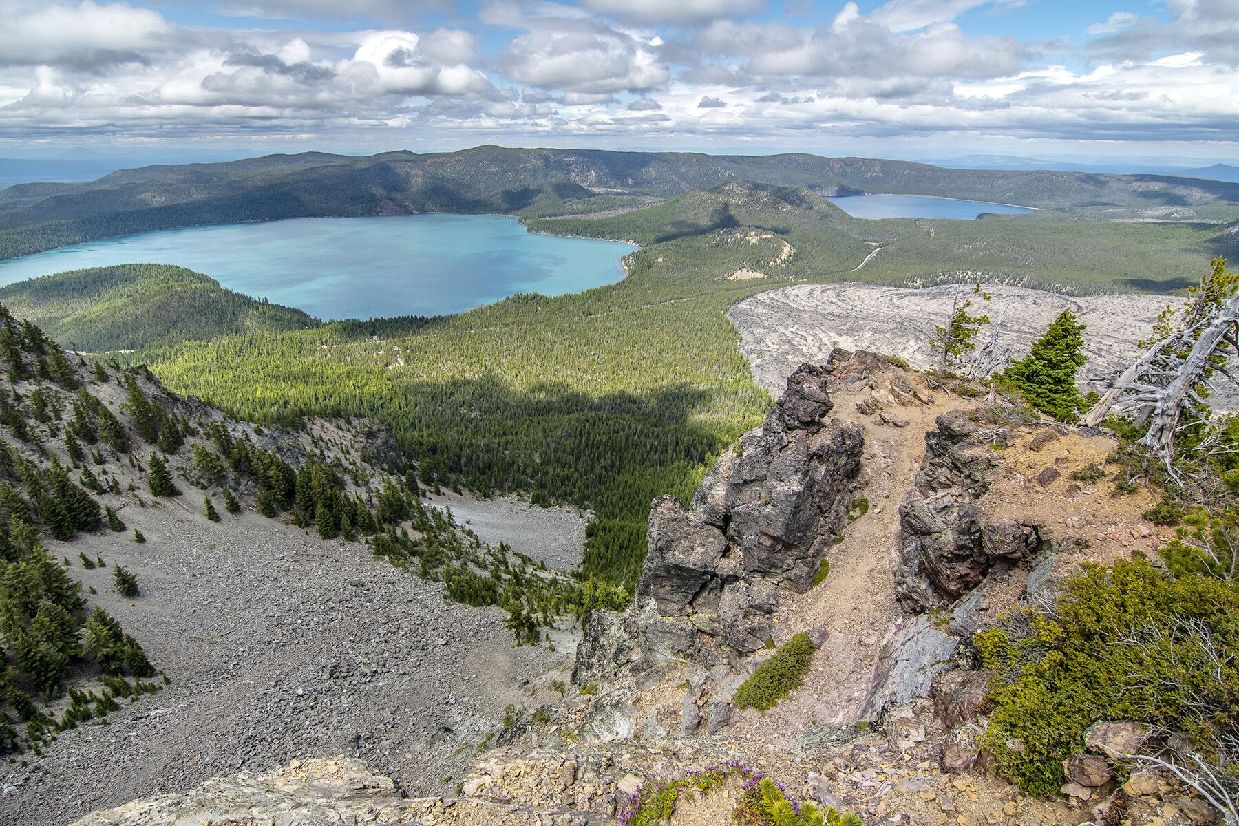
Do: Designated in 1990, this 83-square-mile tract managed by the U.S. Forest Service is a font of colorful, dramatic rock formations, parts of which—like Lava Lands Visitor Center with its excellent exhibits on the region’s tumultuous geological history and drive-up Lava Butte Cinder Cone—are easily reached right from U.S. 97, as is the excellent High Desert Museum, which contains art, natural history exhibits, and outdoor areas that allow up-close viewing of native wildlife. Also nearby, you can walk through the 1-mile-long Lava River Cave. And a little farther afield, Newberry Caldera and Paulina Lake—an azure body of water formed within an ancient volcanic crater—are beautiful places to explore, offering views of 7,985-foot Paulina Peak and ample opportunities for hiking and waterfall viewing.
Eat & Drink: The sunny, outdoorsy city of Bend, just 15 miles north of Lava Lands Visitor Center, has an impressive bounty of hip, world-beat eateries and coffeehouses, and one of the best craft breweries in the country. Top dining spots in the city’s lively and walkable downtown include Wild Rose, for some of the best northern Thai cuisine in Oregon, and Joolz, which turns out delicious, creative Middle Eastern fare with locally-sourced ingredients. Beer lovers shouldn’t miss long-renowned Deschutes Brewery & Public House and the edgier and experimental Crux Fermentation Project.
Stay: Bend has dozens of lodging options, including the attractive and centrally located Oxford Hotel, which is steps from downtown eateries, shops, and the Bend Farmers Market. If you’d rather be closer to nature, consider booking a room at Sunriver Resort, a scenic, pastoral retreat with exceptional golfing, tennis, and spa facilities—it’s just 6 miles from Lava Lands Visitor Center.
Breakfast: As you depart Bend, drop by the convivial Sparrow Bakery for a well-crafted espresso drink and one of the heavenly breakfast sandwiches. The pastries and cookies here are worth stocking up on, too.
National Volcanic Monument to Mt. St Helens, Washington
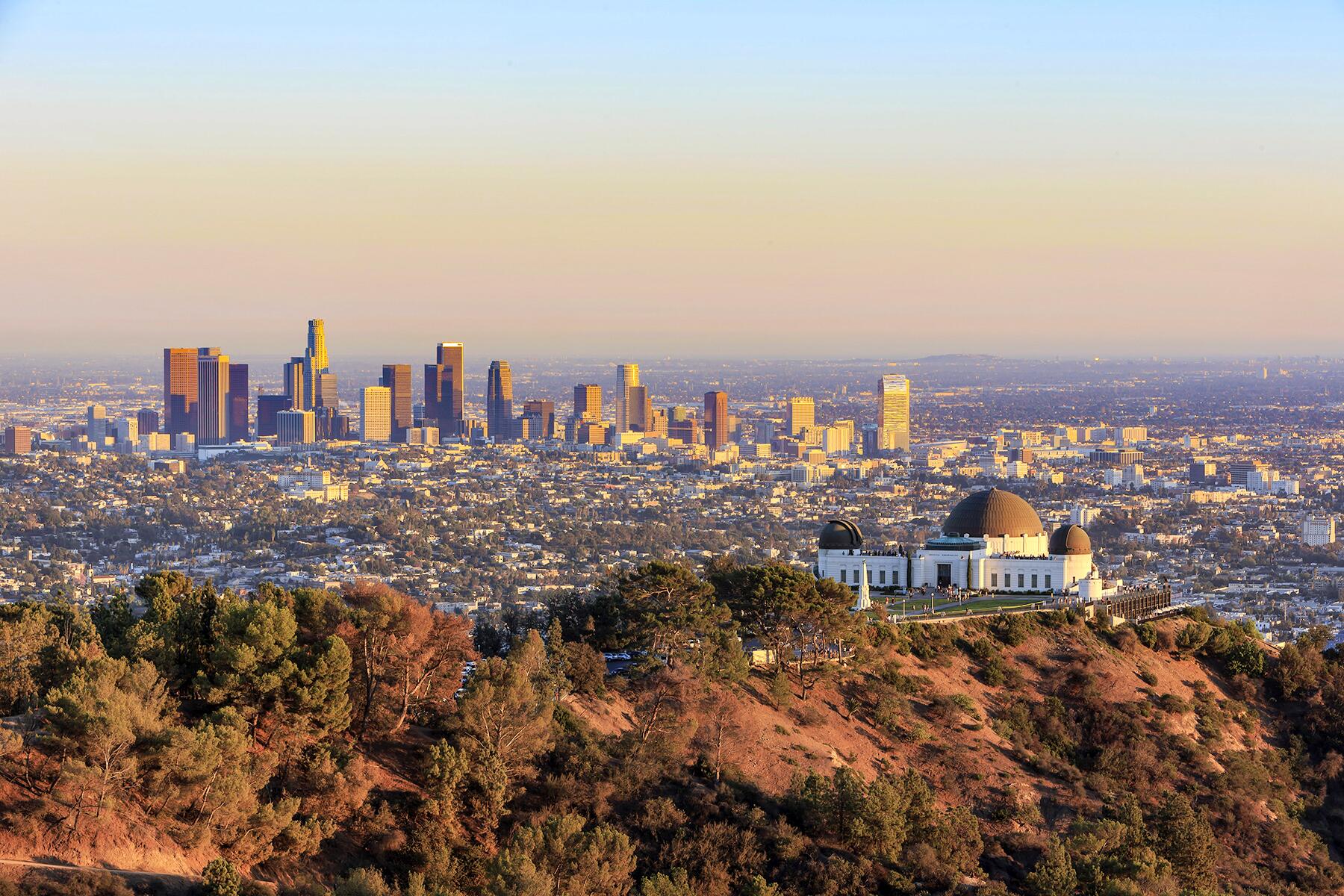
Town: Mt. Hood. Oregon’s highest peak, 11,250-foot Mt. Hood soars dramatically above the eastern edge of the Willamette Valley and the storied Columbia Gorge. Just off U.S. 26, follow Timberline Highway about 6 miles up to historic Timberline Lodge, which was built by the CCC (Civilian Conservation Corps) in 1937 and offers majestic views of several other peaks in the Cascades. Optionally, for an even more scenic trip, detour from U.S. 26 after visiting the lodge, following Hwy. 35 north to the free-spirited, scenic river town of Hood River. From here, via either I–84 on the Oregon side of the Columbia River, or Hwy. 14 on the Washington side, you can drive through the spectacular Columbia Gorge—an 80-mile expanse of 4,000-foot-high cliffs with some great hikes and state parks along the way—eventually joining I–5 north to Mt. St. Helens. It’s worth noting that Portland is an attractive, manageable city that you’ll also skirt along this route, and those with a bit of extra time might consider spending a night or two enjoying that city’s lively restaurant, shopping, and bar scenes.
Eat & Drink: The Ram’s Head Bar inside the Timberline Lodge, on the slopes of Mt. Hood, is an atmospheric spot for lunch or dinner, either in the bar area which overlooks a massive 90-foot-tall stone fireplace or the Cascade Dining Room, with its forever mountain views.
Nature: If you travel by way of I-84 through the Columbia Gorge, do stop to view the staggeringly high Multnomah Falls, which drop 620 feet from a sheer cliff. You can hike to the top, and reward yourself with a slice of blackberry cobbler in the 1925 lodge at the base. There are also dozens of fantastic hikes in the Gorge on both sides of the Columbia River, including Mitchell Point and Angel’s Rest on the Oregon side, and Beacon Rock State Park‘s Mt. Hamilton on the Washington side.
Do: On the fateful morning of May 18, 1980, 9,667-foot Mt. St. Helens erupted laterally in a northerly direction, emitting 4 million cubic yards of debris over a 230-square-mile area and killing 57 people. Today, you can learn about this volcano, which now stands a bit shorter, at 8,365 feet, and its fascinating and frightening history through outstanding exhibits—which include a scale model of the mountain that you can actually walk through—at Mt. St. Helens Visitor Center at Silver Lake, along Hwy. 504, a few miles east of exit 49 of I–5. You can drop by year-round, but the most exciting place to learn about the mountain is Johnston Ridge Observatory, which is open mid-May through late October and is reached via a dramatic, winding 52-mile drive along Hwy. 504 (aka Spirit Lake Memorial Highway). At the observatory, which is named for a scientist who lost his life in the blast, you can watch a stunning film that recounts the eruption and enjoy a relatively close view of this still awe-inspiring mountain. If you’re an experienced adventurer, you might even consider hiking the 8-mile round-trip Harry’s Ridge Trail from the observatory to the crater (plan to depart at dawn and allow 10 hours round-trip, and before you set out, obtain a permit from the Gifford Pinchot National Forest office).
Eat & Drink: In this remote land, food options are limited, but in summer, Fire Mountain Grill at mile marker 19 of Hwy. 504 is a good bet for burgers and other short-order fare.
Stay: Although you’ll find some reliable if predictable chain options relatively nearby in Kelso and Longview, at the start of Hwy. 504, the most interesting lodging in the vicinity is McMenamins Kalama Harbor Lodge, a 25-minute drive south of Castle Rock along a picturesque stretch of the Columbia River. An added bonus is that there are several lively bars and eateries on the property.
Breakfast: In Castle Rock, Vault Books & Brew is a charming bookstore and cafe that offers an array of lattes, teas, breakfast sandwiches, and pastries, along with a great selection of books for sale.
Mt. St. Helens to Mt. Rainier, Washington
Town: Mossyrock. About midway along your drive to Mt. Rainier from Mt. St. Helens, you’ll drive over Mayfield Lake near the quiet town of Mossyrock. This pretty woodland community makes for a pleasant stop, perhaps to enjoy a picnic lunch on the water at Mayfield Lake Park, or even a quick swim.
Eat & Drink: Owned by a celebrated mountaineer who holds the record for climbing Mt. Everest the fastest, Wild Berry Restaurant in Ashford is popular with Mt. Rainier hikers and climbers as well as just about anybody with a hankering for filling Nepalese food. The menu also features a number of American dishes, including the namesake dessert, homemade wildberry pie.
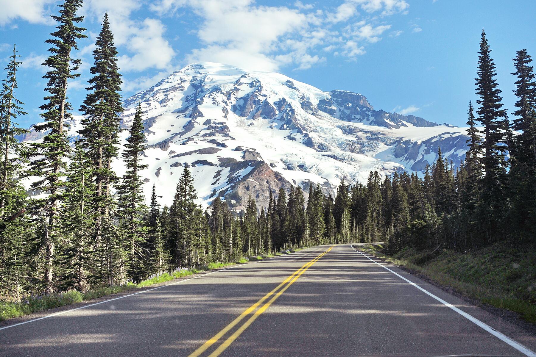
Do: Easily visible from Seattle and Tacoma on clear days, forever snowcapped Mt. Rainer soars to an elevation of 14,411 feet, its summit a favorite destination of serious climbers. For most, a visit to the park begins with a look at the natural history exhibits inside the beautifully contemporary Henry M. Jackson Memorial Visitor Center followed by a stroll amid the wildflower-carpeted meadows around the park’s lofty Paradise section, on the mountain’s southern slope. One slightly ambitious but highly rewarding hike from this area is the 5-mile round-trip Skyline Trail, which leads over sheer alpine ridges to an astounding overlook, Panorama Point. The drive through the park offers a number of impressive stops through myriad terrains, including two-tiered Christine Falls and the Longmire Museum, from which you can enjoy a quick but enjoyable trek along the half-mile Trail of the Shadows nature trail.
Eat & Drink: The window-lined restaurant inside the historic Paradise Inn is a favorite for Sunday brunch and to soak up grand views of the mountain, while the National Park Inn Dining Room down in the Longmire section of the park offers up traditional American comfort fare and tasty blackberry cobbler à la mode.
Stay: Spending the night inside the park at historic 1917 Paradise Inn is a much-sought-after experience, as the view of the mountain, when it’s visible, is tremendous from the grounds and even some rooms. Just west of the park, the reasonably priced Nisqually Lodge in Ashford has nicely updated rooms and a common area with a big fireplace.
Breakfast: The homey, roadhouse-style restaurant at the Copper Creek Inn in Ashford is long beloved for its biscuits and gravy, fluffy pancakes, and other comfort classics.
Mt. Rainier to North Cascades National Park, Washington
Town: Leavenworth. A few minutes’ drive up U.S. 2 from U.S. 97 near Cashmere, this quirky alpine village reinvented itself in the 1960s to resemble a colorful Bavarian village. There are dozens of offbeat shops and galleries, a growing crop of wine-tasting rooms, and some excellent restaurants and craft-beer bars.
Eat & Drink: You’ll find several opportunities for noteworthy dining along this route. For a brunch or lunch with a storybook view, stop at the legendary Salish Lodge, whose dining room overlooks Snoqualmie Falls (both the building and the falls appeared famously in David Lynch’s Twin Peaks). Among the several terrific restaurants in downtown Leavenworth, Yodelin Broth Company stands out for its savory bone broths and burgers, and for a spacious beer garden overlooking the Wenatchee River. Finally, closer to the park in tiny Twisp, Tappi serves fantastic wood-fired pizzas and hearty Italian food.
Nature: A stunning 50.5-mile-long fjord, Lake Chelan stretches north from the town of Chelan into a remote but beloved section of North Cascades National Park that’s accessible only by a scenic boat excursion and is home to the secluded hamlet of Stehekin. Relatively few visitors make it to this part of the park, but if time allows, consider a day-long trip here by boat or even an overnight in one of the rustic but inviting cabins at the Silver Bay Inn. If you can’t make it all the way to Stehekin, stop by Lake Chelan State Park and Twenty-Five Mile Creek State Park, which are just off the main route from Mt. Rainier to North Cascades, and perhaps drop by one of the many wineries set around the south end of the lake, here in one of Washington’s most rapidly emerging wine regions.
Do: This somewhat underrated and remote park that’s home to many of the last surviving glaciers in the lower 48 as well as nearly 800 square miles of stunning wilderness and glacial lakes has few facilities. Apart from above-mentioned but remote Stehekin, the park’s most popular draws are the 95-mile stretch of Hwy. 20 (aka the North Cascades Highway) that traverses the park and offers a slew of hiking trailheads—some of them through coniferous old-growth forest—and memorable vistas, the most famous of which is 5,477-foot Washington Pass. If you’re driving through the park in just one day, stop and soak up the views of intensely turquoise-blue Diablo Lake from the vista point at mile marker 132, and check out Gorge Creek Falls, where you can admire a radiant 242-foot cataract. For a more immersive park experience, visit the North Cascades Environmental Learning Center at Diablo Lake, which leads guided tours, hikes, and canoe excursions.
Eat & Drink: Within a 45-minute drive of the park’s eastern entrance, the Wild West-inspired village of Winthrop has a few esteemed restaurants. Arrowleaf Bistro is a top pick for creative farm-to-table cuisine, and you’ll find a handful of colorful bars, including the groovy Copper Glance cocktail lounge and the Old Schoolhouse Brewery, overlooking the Chewuch River.
Stay: Other than the famously remote Silver Bay Inn in Stehekin, there aren’t any lodgings in the park. But you’ll find some great options nearby to the east. Surrounded by coniferous forest and set high on a bluff above Winthrop, Sun Mountain Lodge offers attractive, woodland-inspired rooms, many with wood-burning fireplaces and mountain views. And the secluded Mazama Country Inn offers reasonably-priced rooms in a handsome main lodge building as well as family-friendly cabins and is close to the eastern side of the park.
Breakfast: Just outside the park’s east entrance, the Mazama Store is a beloved general store stocked with everything from outdoor gear to quirky gifts. Here you’ll also find fresh-baked artisanal breads, fine coffees, and plenty of tasty breakfast items.
North Cascades to Olympic National Park, Washington
Town: Edmonds. This attractive, bustling waterfront community is a relaxing place to while away some time during your wait for the ferry to Kingston. There’s a scenic park, Olympic Beach, which overlooks the water and Whidbey Island in the distance, as well as exhibits at the excellent Cascadia Art Museum, and just a few blocks up the hill, downtown abounds with lively boutiques and eateries.
Eat & Drink: Epulo Bistro in downtown Edmonds serves up tasty Mediterranean-inspired tapas and has a great wine list. On the Kitsap Peninsula, consider stopping for a grilled pork banh mi, a bowl of local clams with garlic butter and white wine, or the decadent butterscotch pudding at Butcher & Baker Provisions, a gourmet deli, cafe, and specialty-food market in historic Port Gamble.
Detour: Keep in mind that Edmonds is just 15 miles north of Seattle, so this would be a good point in this trip for a detour to this cosmopolitan, picturesque city on Puget Sound. If you’re just breezing through for the day, focus your efforts around the waterfront and famously colorful Pike Place Market, but there’s enough to keep you busy in this buzzing metropolis for days and days.
Do: One of the most geographically-diverse parks in the country, this 1,442-square-mile expanse of jagged, snowcapped mountain peaks, peaceful rainforests, rippling alpine lakes, and stunning, boulder-strewn beaches is best enjoyed over a few days, ideally overnighting in a couple of different areas. If you’re short on time and have just one night, plan to stay in Port Angeles and drive to mile-high Hurricane Ridge for the rugged 3-mile Hurricane Hill loop hike. Then as you make your way around the Olympic Peninsula, spend an hour or two traipsing through Hoh River Rain Forest—sometimes dubbed the quietest place in the United States—and time your visit to explore the coast at Ruby Beach and La Push late in the day to enjoy the sunset. If you’re able to spend a bit more time in the park, explore the shores and nearby woodlands of Lake Quinault and its gorgeous Lake Quinault Lodge.
Eat & Drink: The convivial Next Door Gastropub in Port Angeles is a great option for lunch or dinner, serving elevated tavern fare like local Dungeness crab cakes with house-made tomato chutney and lightly spicy seafood green curry, and offering a great selection of craft beers. Overlooking a magnificent stretch of ocean inside the park, Creekside Restaurant at the beautifully situated Kalaloch Lodge hotel serves tasty smoked-bacon clam chowder and ale-battered Pacific cod fish and chips.
Stay: There are a few beautiful lodges inside Olympic National Park, with the peaceful 1916 Lake Crescent Lodge being the closest to Port Angeles and the Hurricane Ridge section of the park as well as offering easy access to Sol Duc Springs area (which has its own park lodging, the Sol Doc Hot Springs Resort, a 1910 property deep in a lush rainforest and offering hot mineral-bath soaks). The lodge has both simple rooms with shared baths and one- and two-bedroom cottages and cabins overlooking the lake. There are lots of options in every price range in the small city of Port Angeles, but as a popular place to catch the ferry to Victoria, BC, the it often books up quickly in summer.
Breakfast: In downtown Port Angeles, charming Chestnut Cottage has earned a well-deserved reputation for some of the best morning fare on the Olympic Peninsula—try the bacon-and-Brie scramble or the rich crème brûlée French toast.
Olympic National Park to Lewis and Clark National Historical Park, Oregon
Town. Aberdeen. A dignified logging and port city with a pretty location at the east end of Grays Harbor and the mouth of the Chehalis River, Aberdeen is the Olympic Peninsula’s southern gateway. It’s filled with fine late-19th-century mansions and downtown commercial buildings. You’ll find some storied saloons from the city’s rough-and-tumble seafaring days, like Billy’s, a former brothel that dishes up some of the heftiest burgers in Washington. Fans of Nirvana should stop briefly at the Kurt Cobain Memorial, a small, peaceful park that hugs the banks of the Wishkah River on the east side of downtown.
Eat & Drink: A lively, sophisticated spot for a late-afternoon happy hour or dinner of seasonally sourced farm-to-table fare, downtown Aberdeen’s Redviva occupies a pretty space decorated with reclaimed wood and glass.
Do: Established in 2004 to commemorate the 1804–1806 Lewis and Clark Expedition, this engaging historical park has units on both the Washington and Oregon sides of the mouth of the mighty Columbia River. Spend the morning in Oregon, visiting the interpretive center and re-creation of Fort Clatsop, and set out on the 1½-mile Netul Landing Trail. Later in the day, cross back into Washington to explore Cape Disappointment State Park, with its rugged sea cliffs and beach hikes, two lighthouses that you can reach by short and easy trails, and the Lewis & Clark Interpretive Center, which is perched high on a bluff and presents interesting exhibits about the Corps of Discovery expedition as well as the region’s natural and human history. This part of the park is beautiful at sunset.
Eat & Drink: On the Washington side, the courtly 42nd Street Cafe and Bistro serves exceptional Pacific Northwestern fare with both Southern and Italian influences and is located in the charming village of Seaview, at the foot of the Long Beach Peninsula. Across the striking U.S. 101 Astoria–Megler Bridge in Oregon, bustling and historic Astoria abounds with excellent restaurants, bakeries, bars, and brewpubs. Producing world-class IPAs and with a restaurant whose plexiglass floor panels allow you to view barking sea lions on the rocks below, Buoy Beer Co. overlooks the Columbia and serves creative comfort fare, with an emphasis on seafood.
Stay: Facing the ocean in the town of Long Beach, Washington, the adjoining Inn at Discovery Coast and Adrift hotels have smartly designed rooms, beach access, and a terrific rooftop restaurant, Pickled Fish, with sweeping ocean views and live music many evenings. Among the several appealing lodgings in Astoria, the Cannery Pier Hotel stands out for its dramatic setting on a dock beneath the Astoria–Megler Bridge—many rooms have claw-foot or jetted tubs and fireplaces.
Breakfast: Street 14 Cafe, inside downtown Astoria’s quirky Commodore Hotel serves superb fried egg sandwiches with cheddar and salsa verde, and satisfyingly crumbly chocolate-orange scones.
Lewis and Clark National Historical Park to Oregon Dunes National Recreation Area, Oregon
Town: Yachats. Among the many enchanting little towns along this drive, Yachats (pronounced yah-hots) stands out for its dramatic setting, nestled against evergreen-shrouded hills at the mouth of the river for which it’s named. The small downtown has a clutch of excellent restaurants, and nearby Cape Perpetua Scenic Area is a great place for a short hike to an 800-foot-high ocean bluff or tidepooling along the rocky beach.
Eat & Drink: Just off the airy lobby of the chic Headlands Coastal Lodge & Spa in the beach town of Pacific City, Meridian Restaurant & Bar is a snazzy yet unpretentious space where you can sup on well-curated cheese, meat, and pickled-vegetable boards, sip Oregon wines, and soak up beautiful views of the ocean.
Photo Op. On U.S. 101, just a quarter-mile before you reach Sea Lion Caves (which is itself a touristy but fun stop), pull into the small cliffside parking area and aim your camera north up the coast. The view takes in Heceta Head, a rocky, grassy promontory with a dramatic red-roofed 1894 lighthouse and several outbuildings, including the old lightkeeper’s residence, which is now the distinctive Heceta Head Lighthouse B&B.
Do: Encompassing a 40-mile swath of shoreline that’s home to the largest expanse of natural sand dunes in North America, this popular spot for beachcombing and dune buggy rides is a fun place to kick off your shoes and cavort in the wind and sun. Some dunes reach as high as 500 feet. At Honeyman Memorial State Park, in Florence, you can book dune buggy tours. For a quieter ramble, pull off at the Oregon Dunes Day Use Area, just off U.S. 101 across from Lost Lake (near mile marker 201), and scamper among these giant mounds of sand.
Eat & Drink: At the north end of Oregon Dunes, historic downtown Florence, set along the Siuslaw River, has a handful of excellent restaurants, notably Waterfront Depot, which is set in a vintage rail depot and serves innovative seafood and Pacific Northwestern fare.
Stay: Florence has a number of attractive hotels and motels. The River House Inn, in the charming Old Town area, stands out for its spotless rooms, many with patios overlooking the Siuslaw River.
Breakfast: In Reedsport, family-friendly Harbor Light Restaurant doles out big portions of seafood omelets and French toast for breakfast.
Oregon Dunes National Recreation Area to Oregon Caves National Monument, Oregon
Town: Grants Pass. A friendly community with a bustling downtown along the scenic Rogue River, Grants Pass is famous for fishing, white-water rafting tours, and jet-boat excursions on the Rogue River, and it’s also one of the gateways to the Rogue Valley Wine Country, which you can access by detouring a bit off this route toward the quaint Old West-style town of Jacksonville (via Hwy. 238). The downtown area is pretty to walk through and has a number of inviting cafés and shops, and if you have some extra time, Orange Torpedo offers float and rafting trips along the Rogue, and just outside town, Wildlife Images Rehabilitation and Education Center is a wonderful place to view and learn about rescued native animals, from mountain lions to owls.
Eat & Drink: A historic—and allegedly haunted—stagecoach stop that completed a full renovation in 2019, Wolf Creek Inn has a lively tavern offering up Texas-style barbecue, cold beer, and live music. Located on a lofty mountain pass just off the interstate between Roseburg and Grants Pass, it’s a great stopover for lunch or an early dinner. The inn also offers reasonably priced accommodations, if you’re looking to break up the trip with an overnight.
Do: Comprising a labyrinthine network of passageways and marble caverns filled with fascinating calcite formations, this slightly off-the-beaten-path national monument enjoys a dramatic setting not far from the Oregon–California border. The caves are open spring through fall, and the half-mile underground tours, which can be a bit challenging and involve climbing and descending some 500 stairs, last about 90 minutes. If you’re a bit claustrophobic or otherwise not up for a cave tour, you can also hike above ground through miles of picturesque old-growth forest that features some of the tallest and most impressive Douglas fir trees in Oregon.
Eat & Drink: Dining options are limited in these parts, and the one restaurant in the park is closed through at least 2020 as it’s located inside the Oregon Caves Chateau, which is undergoing renovations. In the nearest town to the park, Cave Junction, there’s reliably good pub fare—including the restaurant’s signature broasted chicken—at lively Wild River Brewing & Pizza Company. About an hour north in Grants Pass, you’ll find a much greater selection of dining options, including the excellent Twisted Cork Wine Bar, which carries an extensive list of Southern Oregon wines as well as shareable fruit, cheese, and meat platters and heartier dishes, like ginger-glazed salmon.
Stay: Inside the park, Oregon Caves Chateau is a fascinating old property but is closed for renovation through at least 2020. The nearby Out ‘n’ About resort is another option, and a distinctive one at that, offering uniquely designed treehouses with stained-glass windows, cozy sleeping lofts, swing bridges, and all sorts of other offbeat features—kids love this place. There are some basic motels in Cave Junction, but an hour north in Grants Pass you’ll find the area’s best selection of lodgings, including the Weasku Inn, a refined, historic compound of cabins, A-frame bungalows, and lodge rooms set along a pretty stretch of the Rogue River.
Breakfast: In Grants Pass, the hip and friendly cafe Ma Mosa’s dispenses creative, sustainably sourced breakfast fare like beer-battered fried chicken and waffles and sausage-manchego egg sandwiches. If you’re staying closer to the park, consider Taylor’s Sausage Country Store in Cave Junction for delicious breakfast sandwiches.
Oregon Caves National Monument to Redwood National Park, California
Town: Crescent City. The northernmost town on California’s coastline is one of the bases for visiting Redwoods National Park and an interesting community in its own right, home to Battery Point Lighthouse and Museum, which was built in 1856 and can be visited only at low tide, when it’s possible to walk here from downtown’s pier and jetty. Nearby, learn about local marine mammals, such as seals, dolphins, and sea lions, at the nonprofit Northcoast Marine Mammal Center. You can also view some impressive stands of redwoods near Hiouchi in Jedediah Smith Redwoods National Park, and also learn about these amazing trees at the park’s Hiouchi Information Center, which screens a short film about the park.
Eat & Drink: In downtown Crescent City, SeaQuake Brewing is a must for craft beer lovers, but even if you’re not a fan of hops, the outstanding food makes this airy space with a modern-industrial look worth visiting—try one of the excellent thin-crust pizzas, and save room for a caramel stout ice cream sundae.
Roadside Attraction: Both a retro-kitschy must for photo ops and fun souvenirs, and an opportunity to explore the area’s Redwoods via a six-passenger gondola, Trees of Mystery sits right along U.S. 101, 18 miles south of Crescent City. Upon pulling into this goofy place, you’ll be greeted by a talking 49-foot-tall Paul Bunyan statue—and yes, Babe the Blue Ox stands dutifully beside him.
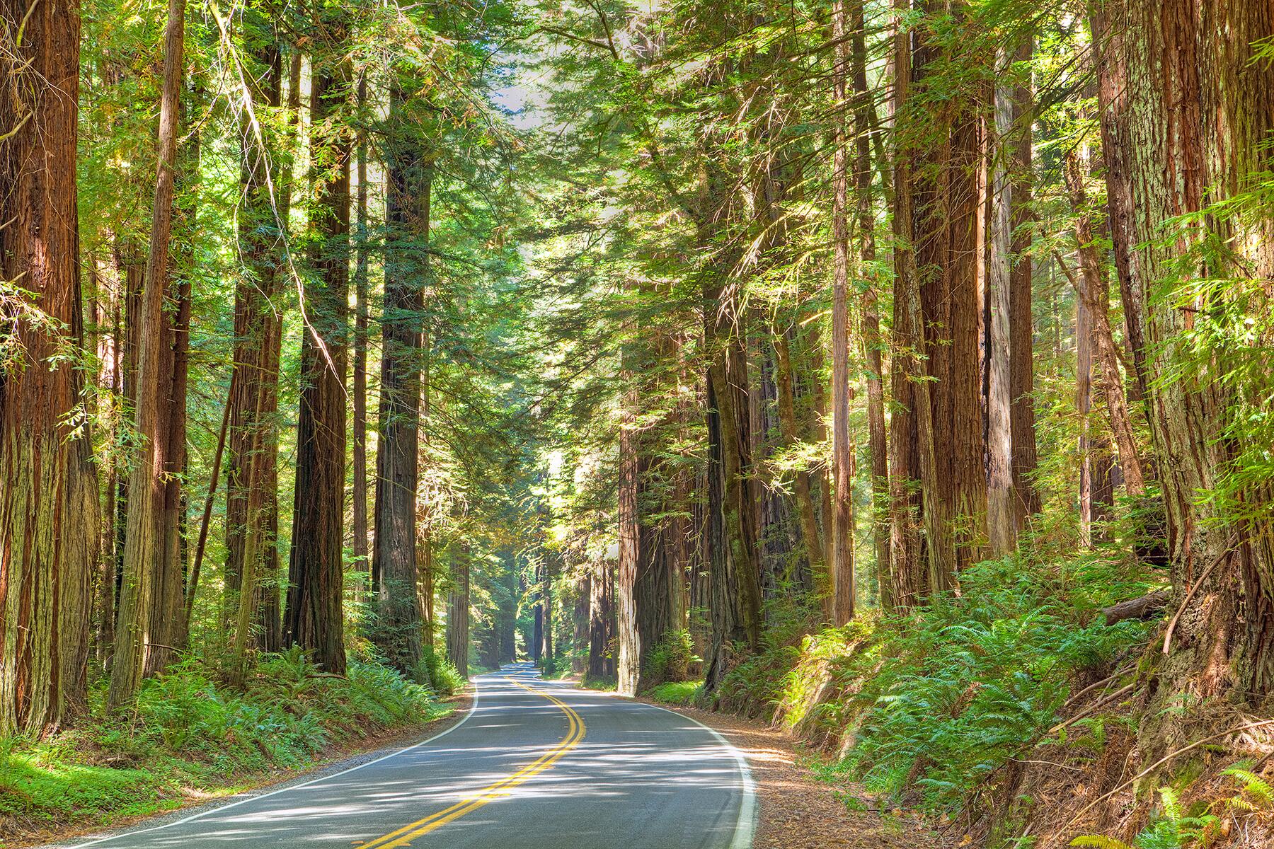
Do: Made up of both federal lands administered by the national park service and several state parks, the officially named Redwood National Park and State Parks is the definitive place to walk amid these towering giants, which can rise to more than 350 feet and differ from the sequoias in that they grow near the coast, and are taller but generally don’t attain the same girth as their inland counterparts. Beyond the aforementioned sites in Crescent City, the park offers several notable places to get out and observe nature as you continue south, starting with Del Norte Coast Redwoods State Park, where you can saunter along the pristine sands of Wilson Beach and False Klamath Cove and explore several large groves of redwoods. The best place to spend the bulk of your time is the Prairie Creek Redwoods State Park section, which is just off U.S. 101. Here you can drive 10-mile Newton B. Drury Scenic Parkway, admiring trees along the way, stopping at several points—notably the Big Tree Wayside—for short hikes. Another highlight in this area is driving to Gold Bluffs Beach and making the short quarter-mile hike into Fern Canyon, a magical 50-foot-canyon carpeted with deer, sword, and five-finger ferns—the dizzyingly lush landscape appeared famously in Jurassic Park 2.
Eat & Drink: Other than in Crescent City, the top restaurants in the area are a bit south of the park in the funky college town of Arcata and the North Coast’s largest city, historic and scenic Eureka. Cafe Brio overlooks Arcata’s town plaza, bakes its own artisanal breads, and serves superb focaccia sandwiches, leafy salads, and creative dinner fare. In Eureka’s Old Town, where you’ll also find quite a few bars and coffeehouses, Cafe Waterfront occupies a rollicking old former brothel and is well-regarded for its oyster burgers, chowders, steamed clams, and other locally caught seafood.
Stay: Both Crescent City to the north and Eureka and Arcata in the south have a wealth of accommodations, from chain properties to painted lady Victorian B&Bs, including the Carter House Inns, which stands out for its central Old Town Eureka location, elegantly appointed rooms, and acclaimed Restaurant 301. You’ll also find some distinctive options near the park’s core attractions, such as Elk Meadow Cabins, a cluster of spacious, restored former millworkers’ cabins with kitchens and a communal fire pit.
Breakfast: In Trinidad, the cheerful Beachcomber Cafe is a great place to pick up bagels topped with chevre, poached eggs, lox, and other delicious toppings, along with organic espresso drinks.
Redwood National Park to Point Reyes National Seashore, California
Town: Healdsburg: One of several picturesque communities in the heart of Sonoma’s Wine Country, Healdsburg has an attractive downtown anchored by a tree-shaded square. Here you’ll find dozens of winery tasting rooms, fashionable boutiques, and fine restaurants. If you have a little extra time, venture west from town via Westside Road, where you can enjoy tastings at some of California’s most esteemed wineries, such Gary Farrell and Arista.
Eat & Drink: You won’t lack for notable dining options along this route, especially once you get to Sonoma County. Even before you hit Healdsburg, Catelli’s Italian restaurant in Geyserville beckons hungry diners with exceptional house-made pastas.
Detour: Although U.S. 101 is perfectly lovely, the far more spectacular alternate route to Point Reyes entails cutting toward the coast in the town of Legget (90 miles south of Eureka) along famously stunning Hwy. 1 and driving down through bustling Fort Bragg, beautiful Mendocino, and the spectacular coastal Sonoma County communities of Jenner and Bodega Bay (famous as the setting and film location of Alfred Hitchcock’s 1962 thriller, The Birds). Going this route adds two hours to your trip, but it affords you the chance to stop and stroll around Mendocino’s gorgeous little downtown perched on soaring sea cliffs, and perhaps to stop for a Dungeness crab roll in Jenner at Cafe Aquatica, which overlooks the mouth of the Russian River, or homemade crab cakes in Bodega Bay at Spud Point Crab Company. Fresh-caught crabs are a beloved delicacy in these parts.
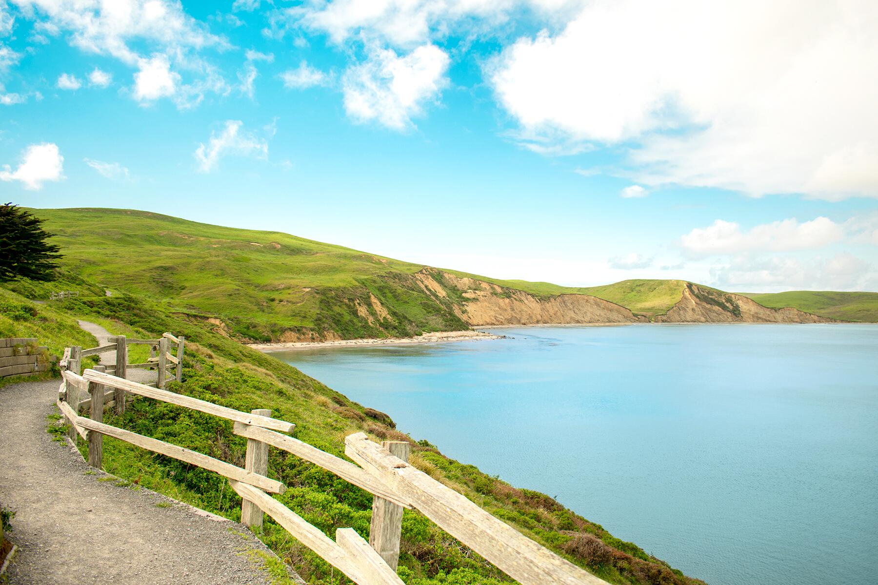
Do: This 71,000-acre national seashore set on a lush, windswept peninsula in the Pacific lies just 30 miles north of San Francisco but feels as though it could be galaxies away. It’s a pristine patchwork of drives and hikes atop 100-foot sea cliffs, along pristine beaches, and past wildlife-rich estuaries. It’s worth driving to the farthest point in the park, Lighthouse Visitor Center, for a trek over a dramatic headland where you can often spy gray whales just off the coast during the winter and spring migratory periods. Among the seashore’s most scenic beaches, Limantour Spit is a gorgeous spot to watch the waves crash dramatically against the shore. Keep an eye out for harbor seals and all kinds of migratory birds, too.
Eat & Drink: Just north of the park with a magnificent setting overlooking Tomales Bay, Hog Island Oyster Co. Marshall Oyster Farm & the Boat Oyster Bar is a delightful spot for locally harvested raw and barbecued oysters—you can even shuck and barbecue them yourself if you’re feeling adventurous. Not far from the park entrance, the village of Point Reyes Station has several inviting restaurants, including Tomales Bay Foods, a smartly retrofitted old barn that’s now a gourmet market. It houses the famed Cowgirl Creamery artisanal dairy as well as shops and counters selling creative sandwiches, luscious gelato, and other treats and picnic goods.
Stay: Just south of Point Reyes Station, the 25-room Olema House is a smartly restored 1860s stagecoach stopover that’s close to the park and has beautiful gardens for strolling and an excellent restaurant, Due West. Another good nearby option that’s a little easier on the wallet, the Cottages at Point Reyes Station offer well-maintained one- and two-bedroom cabins with fireplaces, and a gorgeous setting that encompasses a private 8-acre wildlife preserve. Petaluma and San Rafael, within 30 to 40 minutes of the park, also have plenty of hotels and motels.
Breakfast: In Point Reyes Station, don’t miss the delectable blueberry-buttermilk scones, blackberry-lemon-pear muffins, and ham-and-cheese croissants at Bovine Bakery, where you can also fuel up on espresso and chai lattes.
Point Reyes National Seashore to Pinnacles National Park, California
Town: San Francisco. One of the world’s iconic cities needs no introduction, and sure enough, it’s right on the way between these two parks (you could bypass it through the East Bay if there’s horrendous traffic or you simply don’t wish to drive through a big city, but you won’t likely save any time). If you’re not planning to spend the night in San Francisco and are just looking for a short but enjoyable stop, here’s a good plan: once you cross the Golden Gate Bridge, hop onto Hwy. 1 and head south through the Richmond District, with its wealth of excellent ethnic restaurants, and pause for anywhere from an hour to a few hours in Golden Gate Park, which is home to exceptional cultural treasures like the de Young Museum and California Academy of Sciences, as well as—plant lovers shouldn’t miss these—the San Francisco Botanical Garden at Strybing Arboretum and the Conservatory of Flowers.
Eat & Drink: Near San Francisco’s Golden Gate Park, you’ll find a wealth of great restaurants, especially in the Richmond District (just north) and the Sunset District (just south). Asian eateries are particularly good in these parts, and a couple of standouts are trendy Burma Superstar in the Richmond, and bare-bones San Tung in the Sunset, which is revered for its dry-fried chicken wings and steamed dumplings. Be prepared to wait for a table at either of these places.
Detour: As with the drive to Point Reyes from the north, there’s also a scenic but longer alternative coastal route from Point Reyes south to Pinnacles. It’ll add about 90 minutes to your drive, but the views are gorgeous and there’s little traffic between San Francisco and Santa Cruz. To take this scenic route, when you reach Hwy. 1 after crossing the Golden Gate Bridge in San Francisco, stay on this famous coastal highway and follow it down through the lovely seaside town of Half Moon Bay, and then continue all the way along the ocean to lively Santa Cruz, with its bustling municipal wharf, old-fashioned boardwalk and seaside amusements, and lively downtown. Continue east on Hwy. 1 to Castroville, and turn onto Hwy. 183 to Salinas to once again pick up U.S. 101.
Do: Upgraded in 2013 from a national monument to a national park, Pinnacles is nonetheless somewhat underrated, despite being barely more than two hours away from San Francisco. This remarkable volcanic landscape is bisected by a ridge of jagged mountains. In the eastern section of the park, you can view the excellent exhibits at the Bear Gulch Nature Center, before embarking on the Bear Gulch Trail to the famed Bear Gulch Caves. On the western side, drive to the Chaparral Trailhead area for a grand view of the park’s High Peak, and take the 2½-mile Balconies Cliffs-Cave Loop. For any of these hikes to the park’s caves, make sure you pack a flashlight before setting out. With more time, you could consider hiking from one side of the park to the other and back again via the High Peaks Trail.
Eat & Drink: Dining options are quite limited near the park, but you’ll find a handful of inexpensive, informal options in Soledad, including some excellent Mexican restaurants, like Taqueria Pacheco, a no-frills spot with mouthwatering al pastor, carne asada, and other tacos. North of the park, you’ll find lots of casual options and chains in Salinas and Hollister, but keep in mind that if you’re craving a serious culinary adventure, you could also make the one-hour to 90-minute drive (depending on which side of Pinnacles you’re driving from) to the Monterey Peninsula, with its cornucopia of fine restaurants, bakeries, and wineries.
Stay: The top lodging option near the park, the Inn at Pinnacles is just outside Soledad, along the narrow and scenic road leading to the park’s entrance, and is a stunning Mediterranean-inspired home set on 160 acres of vineyards. In Soledad, you’ll also find a couple of budget motels, and Salinas has several mid-range chain options.
Breakfast: There’s not much near the park, but up in Salinas, you can count on the friendly folks at First Awakenings to fill you up with delicious ways to start the day, including green chile and carnitas scrambles and several varieties of eggs Benedict.
Pinnacles National Park to Channel Islands National Park, California
Town: San Luis Obispo. This attractive town along the central coast, home to prestigious California Polytechnic State University, has an attractive downtown anchored by the 18th-century Mission San Luis Obispo de Tolosa and enjoys close proximity to the ocean, which is just a 15-minute drive west or south, depending on where you access the shoreline. It anchors an ever-growing wine region, and you’ll find numerous wineries and tasting rooms nearby and in other communities along the U.S. 101 to the north, particularly Paso Robles. If you visit on a Thursday evening (from 6 until 9 pm), be sure to check out the city’s famous downtown farmers market along Higuera Street.
Eat & Drink: Famous in the 19th century for its hot springs resorts, Paso Robles is today a font of superb wine country restaurants and tasting rooms and well worth a stop for a memorable lunch or dinner (and maybe some tastings at one of the area’s more than 250 wineries). Among the many superb eateries in town, upscale Thomas Hill Organics is one of the Central Coast’s most vaunted destinations for fine locavore-driven cuisine. For a simpler and less expensive meal, duck into the Hatch Rotisserie & Bar, a casual spot with elevated comfort fare and a first-rate drinks program.
Do: Visiting this nautical park that comprises five islands off the coast of Santa Barbara, Ventura, and Oxnard takes a little extra effort, as the only way to visit any of them is via a boat excursion (or your own private boat). A few different companies offer a variety of cruises to the archipelago, some specializing in scuba diving, kayaking, and other activities. There are no lodging or dining options in the park, other than camping and picnicking, but there are few prettier coastal locales in California for these activities. If you have just a day, the best plan is to stop by the park visitor center in Ventura (there’s also a small secondary visitor center in Santa Barbara Harbor), which features exhibits and shows a film about the islands, which range in size from 1-square-mile Santa Barbara to the quite extensive 96-square-mile Santa Cruz Island (it’s slightly larger than Martha’s Vineyard). You could then take an hour-long excursion on one of Island Packers high-speed catamarans to Santa Cruz Island from either Ventura or Oxnard. Once on the island, you can hike amid the unspoiled landscape of 2,500-foot mountains and dramatic canyons, viewing the many kinds of flora and fauna that thrive here, and learn about the indigenous Chumash communities that once live here. Note that if you’re going beyond these areas and visiting the 76% of the island managed by the Nature Conservancy, you must obtain a permit in advance. Alternatively, in addition to several dive operators, Truth Aquatics offers hiking, sea kayaking, paddleboarding, and snorkeling tours out to the islands that depart from Santa Barbara, and Island Packers offers three-hour whale-watching cruises—spotting these creatures is pretty much a sure thing during the winter migratory season.
Eat & Drink: There are no facilities on the islands, but Andria’s Seafood restaurant in Ventura is near the visitor center, overlooks the harbor and marina, and offers up delicious clam chowder and fish-and-chips. In Santa Barbara, you’ll encounter a dazzling landscape of fantastic restaurants, urban wineries, and craft breweries and distilleries, many of the best of these clustered in the Funk Zone, just off the U.S. 101. Of particular note, The Lark is an artful space that’s highly regarded for seasonally sourced contemporary California cuisine.
Stay: For convenience to the park visitor center and cruises to the islands, the Ventura Beach Marriott in Ventura is an excellent choice. If you don’t mind a slightly longer drive, you’ll find many more interesting options in Santa Barbara, from the ritzy Rosewood Miramar Beach in tony Montecito to the stylish yet economical Hotel Indigo, right in the Funk Zone.
Breakfast: In Santa Barbara’s Funk Zone, hip Helena Avenue Bakery is an excellent spot to start the day with whipped-honey ricotta on sourdough toast or house-made granola. Ventura’s Harbor Cove Cafe is next to the park visitor center and is a great option for picking up a breakfast burrito and coffee, as well as box lunches for the rest of your day, before setting sail for Santa Cruz Island.
Talk to us!
Login or register to comment on this itinerary below or join the conversation with other members on our Road Trips Forum. You can also email a road trip suggestion you’d like us to cover at [email protected].